Typhoon Tip
-
Posts
43,594 -
Joined
-
Last visited
Content Type
Profiles
Blogs
Forums
American Weather
Media Demo
Store
Gallery
Everything posted by Typhoon Tip
-
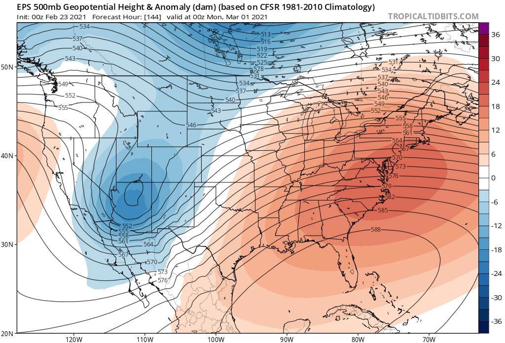
I dunno... hard to ignore the EPS' trending that mid range SE height menace... It's not hugely incremental... sneaking up, maybe like 2 or 3 dm per 12 hour cycle... but should this get much more anomalous we're likely to just see that D5 through D7.5 or 8 end up SE of a wavy stationary freak frontal zone, se of which reside securely inside a dry continental spring conveyor of that deserty 70 F thing - relax ! It's not there yet ..but there's no part of the hemispheric present footprint of La Nina spring and teleconnectors on top that screams that won't happen just the same. I'd like to see the 576 get closer to NYC ... if/when that happens, that's when the operational run has 82 at Albanty lol
-
wow..this 12z Euro run on the 28th - last day of the month.... That is deep spring folks! ... +4 to +5 C at 850 mb with COL pressure pattern, < 50% RH at 700 mb at sun up... sun would bust MOS easily prior to clouding over mid afternoon - and it's possible the ceiling ends up evaporating on that front edge because it's running into weak DVM associated with that little-bubble-no-trouble surface high there. I love that stuff when the new season lays down the law type afternoon. Obviously it's not the defining anything else but that 12z D5 look is a pretty exceptional blue-bird day appeal. That goes right passed nape stage and into legit balm appeal there.
-
Heh... if it's windy no bueno tho - 'nape' only works if it's calm-ish and more sun than cloud. If it's so much at 51% instead of 50% sky coverage ...and the wind is at all noticeable ... the nape appeal is ruined. It really has to be that light wind and sear sun ...where a lazy stroll down ones street lies about the temperature. 49 is "63" ... so forth. Very fragile... I don't frankly like any wind unless it is associated with a Nor'easter, a tornado, a thunderstorm outflow... or the p-wave off a comet impact - otherwise, I find the bluster to be annoying and chilly right up the dial until ... ~ 85 F, then you steadily want more wind because ventilation is needed... But if 67 sunny day with wind bumping you around is a piece of shit day to me
-
you'd be surprised how many of intellects out there read that and its obviousness does not occur to them
-
Symbolically ... yesterday's minoring event appealed to me like a March thing. Today, sun is fighting through a milk sky and it's still managed 44 here. It's like with open blue it woulda torched MOS for 4 or 5 I bet... I thought tomorrow would be nape day #1 but I think that's today. Tomorrow gets to be #2 ...
-
Yeah agreed - ...mused snarkly a while ago about the GFS's propensity to lower cold tropospheric features too far as it is. I don't have a problem with a deep trough intrusion and a 'snappy' cold face smack ... but I don't know if we need Antarctic depths to do it
-
Haha ...yeah, a little voice in there when I typed that sounded something like, "...he's gon' jump on this statement I fear" ...I thought so? but wasn't sure. I figured it for less relevant either way. right
-
That's the thing about this year as we enter this spring and so would be the "lag" counter-part to this facet - I wonder if the combined ( so constructive interference ...) that "might" ( emphasize might - ) exist between the La Nina and the HC, could offset offset that, which has become almost dependable as a weird mid spring blocking plague ... You now, 2018 was this phenomenon incarnate. That was an ENSO neutral year...so even though modestly cool and warm ENSO variance ( I believe ) are almost muted out of contention anyway, that pretty much removes much doubt of whether it was irrelevant leading that spring, yet...we had the screaming hemisphere - probably almost entirely owing to the Boreal perennial winter compressed against this HC shit... What happens? Flow relaxes in March, atmosphere sloshes into a blocking for 3 weeks... boom. As far as the built in... I see that all the time in nature. Unrelated, but it reminds me of a sci fi novel idea I have about Gaia's "war on Humanity" ... Fight the enemy where they are not from Sun Tzu - basically ..the idea is, assess where the enemy is weak, before the war begins, and you play that 'virtual' or null space like it's actual chess piece in the conflict. What happens...or emerges to fill the space, invariable "becomes" a detriment to the enemy. I may not have that exactly right by concept but it seems like that's what the strategy is about... Anyway, I have noticed that the two most guilty civilities in the total anthropomorphic Carbon footprint are, China and the United States ( the latter trailing by some percentage - but percentages are missleading because... American has 350 million Carbon pigs ... but Chine has 1.7 billion...so, per capita - we are by and large the loudest snorters in the hog trough ). What is ironic - as a kind of transcendental protagonism specter more than a descrete form, if you will... - is that these two societies are being placated by NOT sensibly "feeling" the impacts of GW as readily and horrifically as it is being felt among cultures that are less guilty - that's fair... While of course, we squabble across geodetic boundaries of right's to usage and percentage culpability. There's an interesting catch-22 there - human culpability and morality/ethics/virtues ... those purely centric distinctions. Nature? they don't matter to nature. You either are or are not C02'ing the f* out of the future, for everyone. No further doctrine bears any relevancy beyond the fact.. The read would spend a goodly number of pages with character development, and some wit and a lot of boring sociology climatology mash up ... But all the while, this hiding the direct "feel" aspect? there are two metaphors that come to mind: The first is the toad in the boiling water.. If toss a frog in a boiling pot it immediately leaps out. If put the frog in the pot when the water is cold and slowly heat it to boiling, you end up cooked frog. The other metaphor is like GW in this way is turning the oven up to the clean cycle - basically ... burning the gunk out of the system. Gaia is protecting our right to eliminate us as a primary infectious agent by use turning up that dial for her. I'm sorry - it's a slow work day ...I know these are long folks. just musing
-
Like the way you put that ... but, that 'compensating' IS the velocity from increased gradient between the Ferril latitudes and the HC...etc..etc... I have to be honest about something... I remember making an early risk assessing post/series therein about snow at the end of October this last autumn. It was in part telecon timing wrt to the timing of the operational "cadence" - or rhythmic oscillations ... you sort of get a feel for that if you're an Aspergery loner like myself ...lol... joking - ..least I think. But in all honestly, it was also utilizing that booked premmy and lag aspect as a "working theory" due to it's recent many seasons of reduxing.
-
Mm, I'd suggest that it's more "prevalent" in those 3 of 4 years... But since the year 2000, there have witnessed a huge jump in May and October snow and or snow supporting synoptics compared to pretty much the previous 200 year -based suggestion. Just sayn' ... I have Mets outside this engagement ...they're all noting a greater than decadal "seasonal lag/tainting" aspect... It's not just snow per se..either.. But weird pattern orientations in August that are straight out of January - just happens to be 30 dm up in thickness... ... Same May.. It seems to happen just before, and just after ..the steeper gradient of mid winter proper is laid into the hemisphere. So it's real... it's driving cold into mid latitudes over the continent, both prematurely and belated, during respective transition seasons. I wonder if this phenomenon is happening in Europe and across Asia - that's an interesting question..
-
Just keep in mind: ...fearing contributing to 'fake news, 'fake science,' which when it comes right down to it is essentially, 'fake but because it was cleverly sounding it is thus highly convincing' - I don't want to be a part of that. Heh, the Scientific Method, in rough assessment, goes like: observation, hypothesis, data gathering, computation to support or refute hypothesis, conclusion .. where by the hypothesis is compared to the conclusion for go, no-go on. In this modernity ...where is apparently ever overwhelmed by a need for speed and rush to glory... subsuming sagacity, we seemed to have developed a new scientific method. Yeah! So much easier if we can just go from observation, skip all that "unimportant other shit" right to awesome conclusion. Science fictional hypothesis - plausibility replaces the possible, where stimulating knee-jerk specter perpetuates the cinema. It's so bad, that truth has become like trying to come down off a Opiode addiction - it can't be done with clinical intervention. Kidding, I realize you are not taking those ideas to the bank. What is known to be true is HC expansion... It's effect on modulating? hypothesis, only. Having said that... it's pretty damn awesome sounding Unless there have been recent validation constrained publications to the contrary, as far as I am away that's where this is at this time. So hypothetically, it does rather nicely offer an entry into the science method, of formulation of reasonable hypothesis to explain the following observations: teleconnectors have been less dependable as the historic, linear statistic inference use to be... prior to ~ 20 years ago, as a slowly increasingly more coherence. This is true in both atmospheric ones, but also suggestive in longer term ones like ENSO.
-
The 06z operational GFS is the first run of that particular model that has offered any demonstration at all that spatially fits it's own CPC telecon spread - particularly beyond D7..8. Firstly, that weird synoptic "tucking" event at 500 mb up there over eastern Ontario. It was dumped by the 00z Euro .. the previous cycle, 12z yesterday had it, 00z she gone. Meanwhile, the GFS and most GEF members at 00z really are absurdly deep with that feature (March 2nd). We are still deep enough inside 1790 through 1980 winter climatology and so deeper anomalies in general are okay ... Not sure that requires 500 mb heights at 468 dm over the GOM... height depths seldom found in Antarctica - Pretty solid likeliness that is the GFS not having any limitations at all in its ability to lower heights as an ongoing attempt by NCEP to offset global warming utilizing fake modeling. Kidding...but jesus Christ. It does that everywhere ..all scales, dimensions, intents and purpose, in the ongoing maelstrom of atmospheric fluidity. It's egregious... I don't want any V16 ... in fact, I don't want GFS, anymore ... I'm sick of it. For those of us of summer enthusiasm ..it will ruin summer if one spends any time using it during the warm season. Last year, it started about 10 days after the Solstice, driving 300 hour range autumn patterns in July.. It's cold bias is so bad ... just don't f'ing run the model beyond 48 hours until you've figured this shit out... please - Here's another aspect about the GFS based upon multiple seasons of persistence and thus, easy prediction. As we work our way into spring ... there are going to be times when the flow relaxes more and ridging becomes apparent across mid and lower latitudes of the continent in all guidance ... These period "should" be evocative of joy and nape dreams of euphoria for ah, more "normal" seasonal -seeking/guided individuals ( to which, ... NO ONE in this social media represents, of course hahaha )... But nope ... schmuck actually chooses to look at the GFS's surface synoptic... Ooh, and their day was going so good up until that point... when their eyes get a big load of that big pasty ass of a surface high pressure hanging over the log the 50th parallel across S Canada Canada. Sorry just having fun.. .but, that flow out there beyond 8 ... shows that buttocks high pressure tendency - built it, but it shows a lot of relaxed milder thickness and crumbled homogeneous baroclinic tendencies to the layout. The latter is at least encouraging. That seems to also agree a bit with the Euros post D8 ... Normally one would be two tokes into a crack pipe blowjob to ever infer much from either guidance' D8 ..entering spring migraine no less, but both seems to nod to the highly concertted/continuity of the +AO/+NAO/-PNA ... I almost wonder if that period may emerge - given time - with more of a warm push... we'll see -
-
mm yeah, it's modest though. Also, a passage not supported in the present hemispheric mode- destructive interference. It would be interesting to see if that succeeds / .. or even if so, if there's a very noticeable hemispheric response - it could struggle to maintain coherency on that left side of the RMM...but that struggle is equatable to not influencing the pattern just as well. The MJO wave phenomenon has always been a conditional additive. NCEP routinely uses language like, 'constructively interfering' in context of both negative and positive when describing it's presence, when in circumstance ..it is either asynchronous or synchronous against the on-going back-drop hemisphere. When it is constructively interfering (in the positive ) its really like almost what are called 'non-linear' or "synergistic" responses. You know ... sometimes in nature ... 2+2 = 5? Atmospheric 'rogue wave' as a metaphor. Anyway, the resulting pattern can be rather extreme. Phase 8 MJO + recurving typhoon + Asian eddy forcing the WPO negative ... look out! Likely to send the Pacific into a tall meridian structured flow probably presaging a severing into ridge nodes ( blocking) near Alaska given time...etc.. In the other direction, nada... Not only can the resulting pattern not represent the MJO is even there, the wave its self seems to 'bounce off' or routinely decay along the Phase space boundaries within those RMM diagrams without actually progressing through. This season? These late Phase 7 into 8, thru 1 .. 2... that entire left side is in negative interference. I'm not sure I see why that is different suddenly, and why the Euro necessarily will be correct in that. It's own EPS mean is less emphatic about actually getting a coherent wave power outside that inner oblivion. I almost wonder if the very earliest detection of seasonal change is sweeping through the guidance cores...and that neutralization of the compression is allowing the wave to squeak through ... spit ballin'
-
Heh ... sounds like April’s from when we were young. btw .. I figure for Kevin speaking hyperbole but I never “promised” a torchy March. I merely wanted to open to discussion citing clad statistical/ .. scientific reason to suggest that may evolve - pertain to the spring as a total character specifically being unlike the last several But he is right - it would help to actually see it on the charts LOL. Frankly I’m interested in that sneaky northern stream trying to carve back against the flow … And actually the GFS also has a bowling ball out there after that too heh cept I don’t trust the GFS in this scenario though at all. It’s native bias is intrinsically going to fight seasonal change let alone the things discussed just because of its northern domination
-
That'll really glare on Wednesday ... least down here. Looks like light wind and 48 2pm ... that's the first real nape day right there. Fake warm incarnate - with gutter rivulets
-
Timing ... seems so- It comes in at dawn there ...after it was clear and radiated out pretty proficiently earlier overnight, then clouds over right then - cold "capping" ... and then system arrives and works it over a bit... But, by the time advection shift up here it's coming from a warm source with ocean S ..blah blah.. and feeble diurnal adds -
-
Yeah it's research required .. big time. Going forward, out of box presumptive approach to ENSO application needs more than a modicum of caveat emptor ... This year, frankly ...did not really look very La Nina anyway... It looks rather -AO forcing the hemispheric hand, while simultaneously a maintained velocity sensitivity took place below 38 or so N latitude. So it was very split ... ding ding ding! right along the fade latitudes where the Hadley Cell circulation kisses/meets the E along the lower latitudes of the Ferril Cell ( 60 or so N) Mind you, these are not concrete curbs in free space..these are all amorphous atmospheric mass tendency -defined. Anyway, the easterly trades of the Ferril and the westerlies around the HC...that is the cylone band at mid latitudes ( in the means...) and since the hemisphere is so split and gradient soaked in that region, it sheared - it's too much. It almost seems that if we didn't have the -AO dominate above 55 N ... we wouldn't have had a winter.
-
Firstly ...I'd like the attitude to shift away from "yours" haha ... yeah, it's not me, or mine. But I know what you mean - anyway, it is changing over time. The impetus there is/was ...we cannot use the institutional model of ENSO - necessarily ... The building is presently closed down for restoration lol
-
Mm... I'm not sure the El Nino was left to operate on the atmosphere in a vacuum - i.e., lesser unimpeded and allowed fuller proxy. The HC shit off sets the warm ENSO phase as canvas destructive interference ... just sayn' Although it is necessary to point out, these are not absolutes. The thing is ... we can have a huge mega-gongo bomb in any regime. It's just a matter of time... And 40 years isn't much in geological means and consequences.
-
Already over-achieving for me, personally .. I figured this for a shreddy mess on radar with light cat paws failing to completely go over to snow whenever it lights up, But alas! rad looks surprisingly opaque in that level 1 .. 2 green, and that may keep it wet snow at steady clips above Willamantic to Boston despite the NAMs intrusion of 925 mb warming
-
May be a situation that is unstable ... Accepting that... as of 00z operational versions ( and cross-guidance ...) none that I have seen, to date for that matter ..., have really shined on with much appeal that represents just how the warm hemisphere could be given the GEF's -based telecon layout. Right now... readers are, "meh, don't use them anyway..." and defer reading any further, either for that reason, or because I can't write small amounts.. Lol. But, I know what I'm doing. It has been a great tool for advanced prognostic risk assessment in the past. just this season, October, December and January events were all, in part, visualized utilizing implicit signaling and 'synergistic' awareness triggered by observing nuances in the cluster. I'm sure for hardened EPS users...they get the same inference there. They are not useless If the EPS were perhaps twice as 'warm' with its color/anomaly distribution Scott provided ...it would be supported by the GEFs. I suppose seeing the EPS modulating this far is akin to a grudging acknowledgement. It is at least partial, cross -guidance mean support. Even if the operational runs are not interested as mentioned above - which they really ... frustrating are not to an egregious appeal. Failing giving us the early 70 degree ridge bomb that the GEFs EOFs are allowing .. their putting snow threats to the 10th of the month. Not climate unheard of per se - duh. But, climate for dummies, climate is not a prognostic tool. Meanwhile, the operational Euro tries to engineer a D10 NJ model snow event as though the A.I. has become self aware and is doing it on purpose to be annoying. heh. I will mention, ..the extended part of that CPC, PNA prognostic curve has sloped back toward neutral ...Its possible that heralds positive PNA onset... that's not really climate supported with the La Nina ( which by the way... I feel like I'm violating my own doctrine by mentioning that damn ENSO state as much as I have been lately, because I believe still that the total forcing from that factor is being augmented by the HC shit..it's a new frontier in CC ...and though the latter is being researched in the ambit, I personally wonder if the present La Nina is not the hemispheric footing as much as it is La Nina and HC working as positive constructors ) Whatever it is parse-able and in truth contribution ... -ENSOs of these numeral likeness, and recent 12 month back grounds, presaged notably warm springs of lore... 2012 ... 1976. I'm sure there are others.
-
Looks like it's trying to be a 'little critter' ... not cold enough but rad looks solid
-
"age well" hahaha ...wtf. The woman's pushin' 80, Jerry - how well is she supposed to age - jeez
-
thank you very much ... wonderin' when someone might hit on that - It's not a 'blocking vs no blocking' question. Of course not. There are multi-variate circumstantial/conditional influences there ... You could have a PF to Phinn axis of evil, 30" juggernaut in any SD of blocking depending on what's going on to offset destructive interference, or adding to constructive ones. It may be that -3 west based NAOs are harder to do it.. .vice versa the other way or whatever, but there's no on or off about it -
-
I get the hyperbole ..it's all good. But, my thing is about the spring season as a whole, as not being like the last several - that's really it in a nut shell. I never actually put a price tag on March, per se.. although, I think that's the flip month. Yeah, I've had to use some demonstrative rhetoric, but .. when one is going against the tide, they have to employ more momentum to get a current of different point of view across ...you know what I mean. I'm not saying March will roast - Lol... though, like you - I wouldn't hate it. Admittedly... I think the EPS "coming around" - to early to tell, and the GEFs over night as also getting even more indicative of a complete and utter hemispheric pattern change... when then adding these to the climate modes of La Nina and HC expansion stuff... The three of those do not really connote -NAO and 2018 walking through the door. Nor do they connote packing pellet CAA days into May, either. Whether that torches March or April or May remains to be seen. It's like what Scott was joking about earlier ...how you just sort of prime your canvas with 'AN' and go from there? Well, we are add emphasis to the positive direction... So it's actually four layers to the warm spring idea: present telecon spread + La Nina climo + HC expansion + CC... Probably in that order, too. It should be pointed out that in terms of order of magnitude, the telecon spread comes first...etc...