Typhoon Tip
-
Posts
44,568 -
Joined
-
Last visited
Content Type
Profiles
Blogs
Forums
American Weather
Media Demo
Store
Gallery
Everything posted by Typhoon Tip
-
Christmas Eve
-
Was wonderin' about this ... Look at sat and obs, it seems the cold front never really convincingly made it through the area despite WPC's analyzing it through LI As the days gotten on ... the strata/fog bank vanished and/or begun moving back NE and the CU field in CT/RI and western MA has begin moving N. If anything there's maybe some frontal-related SRH in the area too with light by veered llv winds. So...vis shows the skies opening up with ample sun intervals, and KFIT bounces to 81/69 ? Not very convincing as a cool side of any boundary and now we have a mid level mechanic entrance/right jet region. So I go to SPC and CT is about to be Watch boxed..I suspect they may need that up as far as ORH or even Rt 2, but we'll see.
-
the other thing is that the amount of the carbon footprint due to cars by Humanity et al I don't think is really the bigger problem. It's power generation - maybe that has changed
-
That could be misleading. That QPF is taking place in a PWAT saturated warm atmosphere. Doesn't strike me as a Mem or 4th of July weekend, cold misty ordeals. I'm late to the mise-en-scene for this weekend ... so may be missing something, but that has more of elevated DP, thunder in the distance look. Wet times... not all the time. With flood warning when it trains somewhere in BAF area. The QPF charts, Euro and NAM etc, swell and decay along the diurnal modulation - that probably means some solar is getting through. I know - it is going to be hard to see through any other presumptive lens after those summer milestone weekends were so dark-artfully targeted-for-destruction. LOL. Need to a double-session Librium to go with access to weather charts to keep it real. Actually, it will be strata rain at 58 now just because I'm mentioning it - but that requires something more like a exorcism.
-
Tomorrow looks brutal. 93 may do it but zip wind while 72 DP ozone bake
-
Heh.... but it's not the installation of an A/C unit - duh ...wtf - Can't damage the windows and so it's not just at matter of jamming one in and kludging the insall - I was having trouble finding the right kind of brackets - the device needs to 'float' and takes the weight of the A/C unit - so that there isn't damage or physical alterations done to it structurally. Don't wanna lose the warranty
-
I dunno... CO2 released back to the atmosphere above the background geologic processes to absorb it, results in heating the atmosphere of the planet. Inevitably, warm air WILL intrude the polar inner domain, including melting the ice caps. I'm not talking in 10 minutes... Over time - that said, that time ...is speeding up. It is the more culpable longer term system forcing mechanism at this sort of planetary scope and scale. I just think it risky to and borderline evasive to rely upon sub-physical causality to explain melting when these/those sub- scale forcing mechanism have been their through the geological epoch, and only now they matter, for a changed reason.
-
Yeah no kidding ...that went quickly thru, too - swoosh. Also, you can make out an interesting low level cyclonic circulation over the open waters E of PSM, too - that may have helped delay those coastal regions
-
do you have a picture of that unit, the new one ... part of this bracket shit is because I don't want to get a new A.C. and not have a way to install it. I am now nearing the solution for the bracket - I need the unit. I calculated the volume/ BTU and it came out to 9,XXX so 10 is probably just about right. I could just go buy a lot version at Home Depot for 150 - but it'll be a piece of shit and won't last.
-
Cool! Thanks for the idea/advice.
-
I think I know what you mean - no need to post pics ...yeah, it's why I posted a picture of my own - to show the vinyl jam/casing edge. But, the brackets ( "Ivation" ) also appears to achieve what you are suggesting with the your own pine-and-cut DIY suggestion. I guess it can't hear to show, no - Basically, either method: the apparatus 'suspends' the AC unit through the window aperture, without physically impacting/marring the window's physical components. Definitely these are the recourse' for this issue. This is my first foray as a home owner into dealing with AC and replacement windows. I don't have central air, and the previous windows were casings installed circa mid last Century - literally...not merely figuratively. They were that old. Sme were the earliest replacement technology, like 1978. Yet others appeared original; the casings upstairs from somewhere between 1909 ( the home construction ), and the 1970s - wood and single pane, with glazing. I mean, that's like neolithic at this point. So screwing A.C. units in and stuffing insulation foam around the edges was okay for the previous window sets... But, now that I have replaced with these new ones, those/that is no longer soluble. Seems like a simple thing ...but it is and isn't just the same. I was imagining these solutions, but wasn't actually finding them on the web - possibly because I don't have patients for the Internet anymore since it become impractically weighted down in a morass of people trying to sell shit. The better days of the Internet ... roughly 1997 to 2002, are gone - everything after that takes a team of Google engineers to find what you want. Almost as though it's by design too - get the money through the electronic sale, negotiate return or keep after. To avoid that it takes as long to parse through the ambitions of greed and/or special interest groups, as it did doing research back in the 1980s before using the god-damn thing. Jesus .. Going on line now is an endless siege miss-direction to diverge your attention from the linear line of site targeted search - what? in the off chance that you'll put down finding socks to become a gov hating Republican that thinks the hurricane frequency is caused by human rights for lesbians ? It's just a morass now! But that's a digression ... I tried searching for a while and my patience for it all is so thin to begin with I just figured I'd ask and sure enough ... within 10 replies, one trickles in that is a better start. Thanks all!
-
Yes! Now we're getting "warm" - well, hopefully cooler.. But yeah. This is what I had in mind when I first asked about the "AC brackets" - I'll start my solution research here - thx! Course, I have a fuzzy caveman feeling that as soon as I finally complete my state of the art a new AC install that is both secure and insulated, that is when summer will affectedly end - one way or the other.
-
Yeah there’s a warranty on the windows - can’t screw into them. Probably should have mentioned that heh - sorry. that’s why I was researching online with these brackets I’m not sure those are right either. it might be could be a simple solution where the bracket creates a flat surface and the AC on top of that. I got to do lotta insulating around it though-I don’t know. I think most of these modern updated advanced hyper tech windows are intended to go into houses with central air. In any case the AC has to sort of be suspended through the window without actually damaging the window itself or marring like physically screwing screws into the sashing - that’s really at the core of the issue
-
Steve’s solution might still work - if I put a two by four along the outside sill that might make it flat enough. It would maybe be more secure too - I mean the one in there now that needs replacing you can just push that right in from the outside. I mean the inside edge is held up by the top window being closed over but the bottom is just teetering on the bottom edge of the window the whole thing is just fn stupidly sitting there. Probably should call her window company back and start complaining man because I was very clear about this oh you’ll be able to get an AC in there-how. It’s not obvious.
-
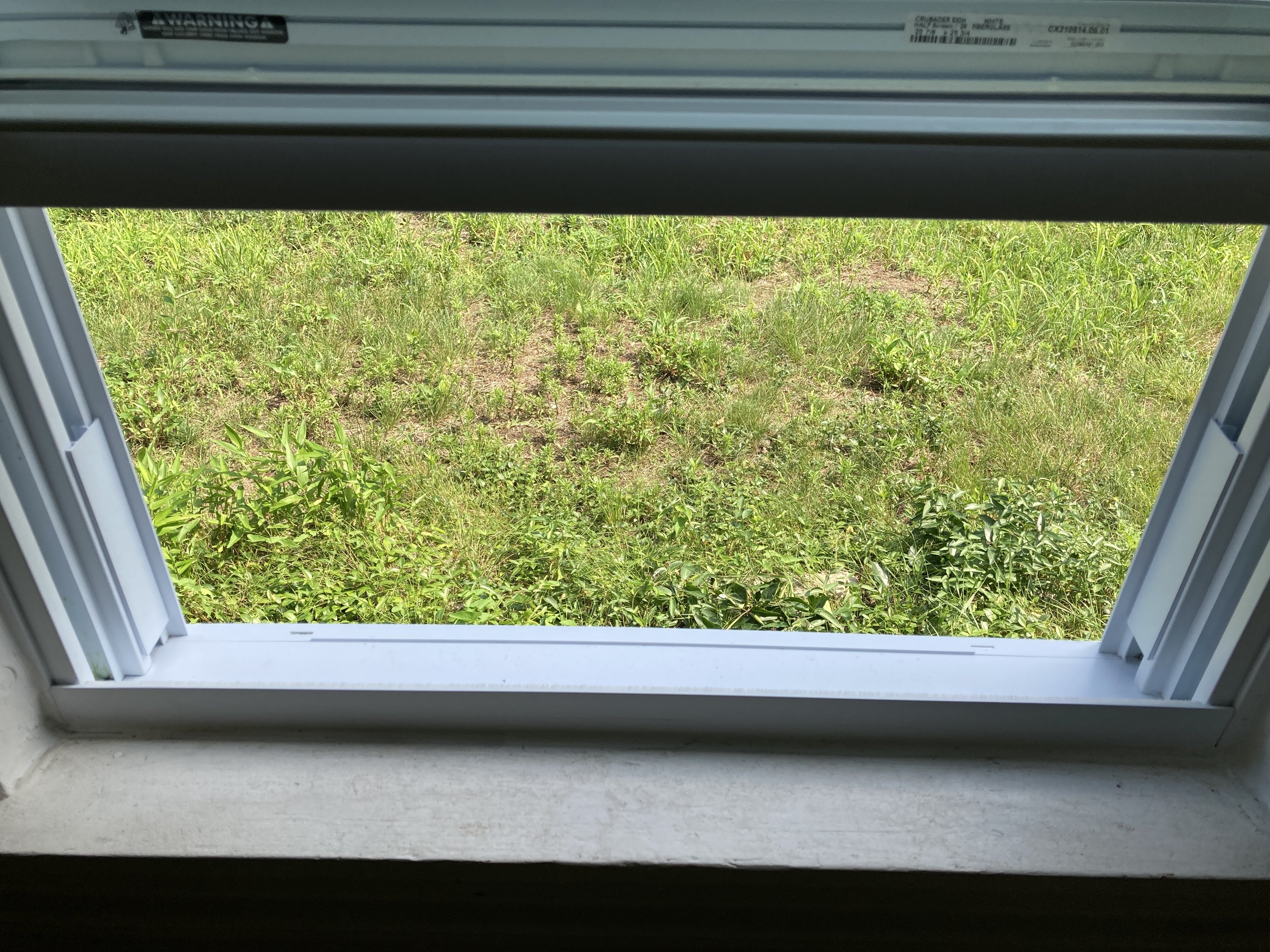
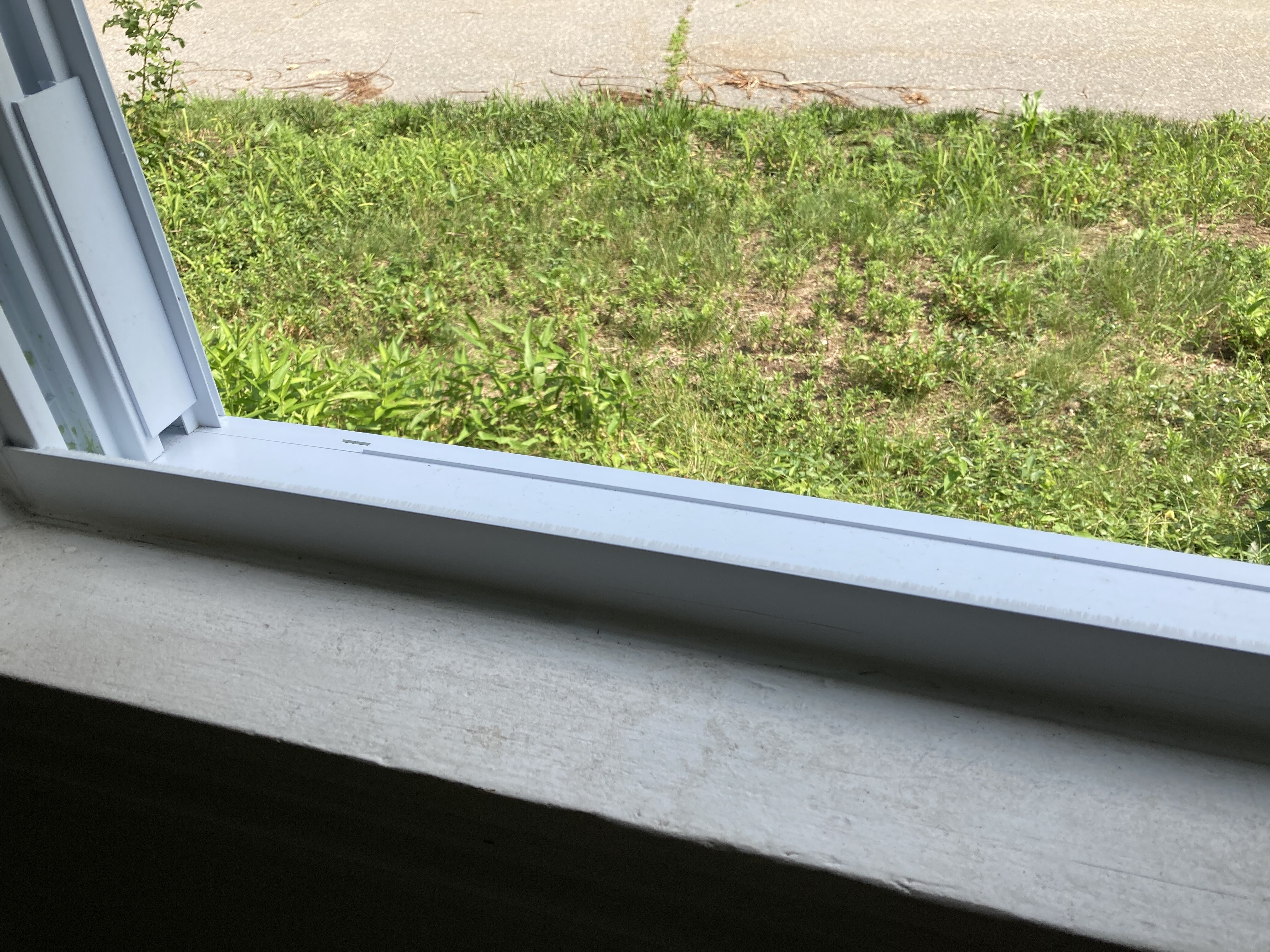
All window AC units that I know of are flat on the bottom and teeter on that edge
-
Yeah I saw that but I don’t think that’ll work. The mid part of the horseshoe structure needs a flat surface in their install diagram and that’s the problem these windows all have a bottom edge sticking up.

-
As you can see there is no flat surface there to house or set the carriage of the AC unit. Thats an edge along the bottom of that window. So whatever gets installed it has to be some other kind of threaded through the aperture of the window without actually really contacting the window or something. Somehow.
-
Man … Does anyone know anything about window AC brackets or these ace braces ? My main living area AC failed and need to get a new one but I also happen to get new upgraded modern vinyl window replacements that unfortunately are not AC- ready Kind of pissed off actually. I was clear that I needed them to be and then I got all these installed and they’re not f*n assholes. I’m just sick of being conned into buying shit that’s white-washed as what I need but it’s not quite right. Need a solution that is right for AC install into replacement windows what is used for this:

-
In any case looks like three days of hot steamy weather probably 89/76 type shit anything to get us snuggling with a heat index of 104 without actually earning us the morbid badge of a heat wave honor
-
Heh. It’s a CC rain event. all acts of anything falling from the sky since 1855 have gotten bigger. Lol But yeah that’s why snow has been prodigious too. They said it’s all built in to the f* climate change/models - so weak kinematics get us too flooding. Nice ! flooding is cool ha
-
The mechanics of that appear too weak to produce that much QPF … perhaps owing to comparatively weaker synoptic forcing but in higher PWAT air mass, thus sensitive to triggering. It’s probably related why everything at that range ends up amplified in the EPS/operational version.
-
nothing like grapple down to Lake Superior - totally normal at the absolute apex of summer
-
Yeah... I used to get into it the life. The clip-in shoes, and the helmet and garb. I turned right down an intersecting street and some teen age nitwit wasn't paying attention and hit me from behind on her bicycle - wasn't even a car... I heard her shriek out in horror just then, and then I as on the ground having just spent 1.24 seconds air born over the handlebars. It takes just that much to ruin a day ..week, month year or in that poor bloke's case, life. I just lost my nerve. I'm mid age and no ambition to be sleek. Fuggit. work out is a work out. I'm perfectly contented now on my high tech Specialized Rockhopper. 'Sides, my road bike was forced retired back in April because it had developed a micro-fracture in the frame some where. Can't be fixed... But, libel to fold up on me going around some tight corner at 33 at some bad point or the other. I'm like ...okay, that's it - I don't care about this hobby that much. So, I outfitted just the back wheel of the Rockhop' with a slick middle hybrid tire tread option, so that it spins okay on roads, and I just hit the bike trails. We have a lot of them around down here now. They can be 12 or even 16 miles long in one direction, so if you can make a good enough distance work out going to the end and back.
-
But aren't those just the same as the stationary bike at the gym ? I mean, I realize with Pel. you get that internet group thing and classes and shit ... But that means nothing to one's physiology. The stationary tech at the gym allows one to set resistance, keep track of calories, MPH and distance traveled ..etc. So you are either turning the peddles at resistance-cadence, or not, right. I'm not sure what the advantage is -
-
I have been wondering that… It seems like the models try to edge towards it finally tipping over and flopping big heights in the east and then it goes right back into some kind of raging early autumn mode driving hgts down thru the great lakes/eastern Canada. and bottling up heights in the west. It’s been oscillating back-and-forth across every two or three days worth of cycles. Could be a major heatwave out there ; could be nothing but blasé for the rest of the way -on the fence as it were