

Typhoon Tip
-
Posts
41,600 -
Joined
-
Last visited
Content Type
Profiles
Blogs
Forums
American Weather
Media Demo
Store
Gallery
Everything posted by Typhoon Tip
-
anyway... the only take away is that a +PNA is arriving and as is typical and proving so again ... it's leading modality heralds with storminess - nothing else ... for now.
-
I'm thinking part of the issue with that 'swirling' non-committed center ... it's very spring-like - Sometimes the mid and extended early April chart will have a deep mid level gyre that looks quite menacing, but has a comparatively weak surface reflection rattling around underneath. Basically in both scenarios such as that ...and probably this? - there's no cold air at low levels to force the frontal structures. It's complex fluid/thermodynamic stuff ... but sharper fronts do things like make upward vertical motion be more "up" ...and not diffusely spread out over broader, shallower frontal surface areas, where by the restoring up under the lifting air regions are also thus spread out - that 'spread out' opens up the low ... with that sort of busted ravioli mess -
-
un-related note... ... can the next person that brings up drought in this social-media's sphere be chastised and ridiculed beyond the very endurance of man please - every f'n June with this gig ya know - ugh
-
yeah... i posted about it over in the Novie thread ... fwi not w ... not a very believable solution due to continuity break -
-
12z GFS with substantial continuity break ... Less multi-stream involvement and really not an altogether trustworthy solution by look in general, but then adding two factors: ( said continuity disruption + PNA in the midst of mode change)/2 = good luck... Tho I still suspect the Euro has an overly smoothed/hyper correction that results in an overly deeply wound up unlikely Lakes solution ( seeing as it is D6/7 when that model bias' toward curvaceous flows anyway..)... I still think it's "smoothing" 4-D variable m.o. might be interesting here in a hour... The GFS is clawing and scraping to get a solution closer to the E/C though -
-
This smacks as a bit of an 'indirect evince' ... evidence of a cultural bias to operate on initial plausibility impulses without constraint ... lacking quantitative/qualitative empirical derived intelligence. I was just reading this article on NPR this morning ... ( National Public Radio, and perhaps one of the last bastions/depots where can be found non-manipulated informatics available for commoner...), https://www.npr.org/sections/coronavirus-live-updates/2020/11/24/938593233/a-case-for-focusing-pandemic-restrictions-on-small-social-gatherings ... nested in those turns of phrase and sentences is penned direct statements where is implicit that a haplessly spied upon hiker with no mask ... represents nominal factor in enhancing spread... Perspective: A hundred -fifty years ago, 'folk' would hunker down with their rifles and shot guns poised, cocked and ready ... Not saying that is 'better', but ...there is a virtuosity in in just waiting ... you know? If by metaphor alone - meaning don't react until you got the facts! ...pending information to act - they didn't know what to do, and they knew that doing the wrong thing could prove far worse - But in modernity? ..we've gone and evolved a sort of 'pathos response' at a cultural level - people are brazen at taking matters into their own hands, hands guided by false information and lack of respect for the process of finding truth... and just assuming the plausibility is veracious. When we bathe lower objective reasoners with information that is intrinsically aggrandized for affect, you 'effect' actions ...and they pull their triggers. ... So, is any 'trail non-compliance' even sufficient enough to be a Pandemic threat? Doesn't appear to be the case as purported by those that actually DO possess said intelligence. Lol, "unconfirmed" ... it's not hard to imagine in this nosy "tattle-tail" society we have these days where high-tech hides douche operator identity ... of course that happened! But maybe I'm just being plausible ... Drone comedy of rural nimrod, line-toeing sycophants to the Covid-19 Reich.
-
Changes on the 00Z guidance ..
-
ha ha... no kidding. wow - we stated our case/logic yesterday ...summarily, the ensuing run cycles actually supported those hypothesis rather nicely ... But then what happens at 12z ? - It's like your family member or friend is in the 12th step of rehab and not hearing from them so you go to their house to find them passed out on the floor in a bender - right back there. i don't know what to make of that... it really doesn't fit that well with the persistence, but ... you know - anomalies relative to anomalies, that's usually where the devil lurks in this business. it's like a Russian nesting doll of anomaly ... The progressive anomaly doll cracks open and out pops an backward anomaly hiccup, just long enough for that thing to happen... then, jumps back inside the other doll after everyone's fun's been ruined lol i dunno ... fwiw, all players are over the Pacific. The intermediate/polar stream wave mechanics won't even relay over land until 4 days from 12z this morning... the vestigial southern stream low doesn't come in until tomorrow.... Meanwhile, the whole ordeal from D6 -10 is during a mode change of the PNA...? There's enough objective uncertainty there not to be sold on this solution -
-
maybe we oughta call these "rhino" patterns ... when the Nina is like the ass-end of a dead rhino .. .it looks like a Nino
-
Don't get me started ... lol - ...
-
K, manual relo of this post - lol: "..At that range (360) ? (EPS mean) mm I'd say that's pretty amped frankly - usually by then entropy has taken over and we end up in the annular look, such that even smaller 'formulaic' structures should be of interest if they are capable of cutting through the morass of a spaghetti layout and still have that signal - In any case, I bet there are a handful of members that are pretty tall in the west... even if there are those that are flatter, too Edit, sure if this is Dec in nature move it -
-
heh... you know guys - we may never get a idealized pattern construct out of the next 45 days anyway - we may have to deal with working out chicken salad out of chicken shit - but I'd take the EPS look and run with it if I were a winter enthusiast faced with the previous - That looks like home grown marginal cold sufficiency to me to be honest - or within range...and those waves could easily morph into a repeat storm scenario... Have to remember, these correction periods are always a problem in the guidance ...at the thresholds of mode changes. you know this ...for the general consumer -
-
Best wishes and hopes for marine interests ... Fwiw, this cycle of the oper. Euro taking steps toward expected correction... Still ends up odd-ball looking at the end of the run, but it's sequencing through a more progressive N/stream now, and I suspect that full stalled Lakes look is in trouble... We're likely to see an r-wave signal pass through the east with this +PNA ...but that's different than the previous Euro/GGEM attempting to conserve it into a singular gyre like previous runs. Not that anyone's paying attention - lol... just sayn'
-
There was an almost identical scenario down there in spring/...or early summer? That one verified... Regardless of ground truth, wtf - to do this twice in the same year, opposing seasons is a curiosity -
-
That's interesting, Scott- yeah... It certainly does not fit the CPC derivatives - LOL... omg, it's actually diametrically out of phase with this - repost of my earlier: ...head scratcher - ... well... okay, if this graphic shit is more accurate than the CPC curve here, than no problem... Late golf light sweaters and shorts with forsythia bud swelling ... Having said that, I usually do pretty well to take the EOF version immediately above and go with that... The anomaly product could be a different metric feed-in/and layout - hell...maybe we're looking at apples and oranges in some sense .. Nah, actually the CPC uses the geopotential anomaly in their EOFs so that only begs the question - wtf!?

-
I am not sure what exactly you are referring to to make that 'distinction' ...and you may be right ...oh, cool - thunder just now... wow but, if the GEFs tele's are right in that which I posted above... I suggest any off-set distinction is correctable ...that would be my guess.. That was implicit in my post - bigger one .. - up there...that I'm not too worried about any daily-scaled bad pattern. I mean I seriously hope you are not using the operational Euro for anything beyond D5.5 in that mess - ew... I like times like these ( lol ) ..it brings meaning to my otherwise pointless existence as a tortured love lorn victim of the gods ... I can hide in high- claims based on my special ( as in helmet and drool cup) aspergery vision, and than challenge to see if they come to realization. Mind you ...said competition is only against myself... Even when I'm more right about these sort of ideas ... I can honestly see vestiges of the other notion were still sort of there?
-
mm .. .the thing is, I personally only see one real factor that objectively limits Dec 2-8 realization/events, over Dec 9 -17 ..etc...so on, outside of noise in data sets that is: The Earth's seasonal/hemispheric lag ... means that it is colder later on... Otherwise? to the natural order of the planetary system that seems like noise ...Problem is perception -
-
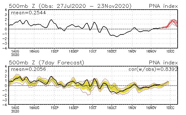
You know... as an afterthought/observation .. the verification curve of the PNA has if anything parted company with the prognostic ranges and is currently more positive already ... You know ...this could 'break' toward more - What else is interesting is the MJO seems destined to decay toward oblivion...after having passe demonstratively enough through Phase 8-1-2 candy district(s)... yet, the GEFs choose some week to 10 days past that termination of existence to blossom it's PNA curve to that appeal - ... hm... Ah hell..could be coincidence ...the MJO's time spent there anyway... I am suspicious that the MJO wave is less capable - similar to the ENSO predicament - of transmitting it's wave signaling into the mid latitudes given the ... uh - yeah
-
Hmm... significant storm tho ? I'd have to say we are above the normal% for a D7-14 ... Whether that is snow ...rain...mix - too soon to tell. ... While not exactly 'calling for' anything, I wouldn't be surprised at all if prior to Dec 10 there is winter complexion event(s) that manage above trivial.. maybe Dec 1 ..and again 4-7th as a non-committal guess. Anyone lucid/cogent objective observer wrt to global events would have to admit to a velocity soaked hemisphere. Why is that going to suddenly change - heh.. fat chance. No..I don't see a Euro or GGEM solution as "likely" to evolve in a fast maelstrom - it's physically stressed .. usually, the path of least resistance and these guidance types seem to be creating their own pathways by removing the speed surplus - interesting. Though that does not mean they can't... (just get that out of the way).. what if things slow down. Assuming not... these guidance' typically do this in that time range, with too much meridian flow... and consummately, they'll have to correct flatter - sometimes more so than others ..etc.. It's like they are running away with the --> PNA mode change, but disintegrating the speed to get to their April looks ...more so evidence in that whacked Euro sell at D10 ... I mean... D10, right? But still ... if any D10 has a 10% chance...that set up is like 1% of that 10% Contrasting, the GFS has a speed bias - of all things ... - which is deliciously, circumstantially hidden from anyone's awareness because it is is carrying on with that bias nested inside a flow that is ... already biased. Ha... like NCEP went out of their way to conceal it's bias in that camouflaging. How devious... anyway, trying to account for that may be less necessary for the orbital perspective - I wouldn't care use the GFS for the daily depiction though. But in this situation ...? It's last two cycles are a way, waaaaay better fit for that persistence/velocity saturation model... during this run mode changing PNA ... We should see a velocity steeped +PNA ... it's a pathway of best intuitive realization ... that conserves the antecedent predicament, while getting the +PNA deed done. But, that doesn't support shortening the planetary wave-lengths... speed = stretching the flow... they should be longer... All the while... this, ... is a whopper H.A. correction signal ... That's why I prefaced this with above median chance for activity. I think given time, that loads enough cold that a first system could be a transition ... and if there's enough to load the circulation anew, the next is colder. I realize some have recently referenced that first week of December's as seemingly preordained in climate to be miserable...not sure I buy that? I remember Dec 2 thru 12 big events many times... 1992, 1995, 1996, 2003, 2005 ... I mean the list goes on... It just I lived through these 12+" spectacles - in fact, I argue, based on that.. .we are more likely to get snow then than f'n Xmass ...but, tongue-in-cheek a little. So, the EPS mean is also a much better look for the persistence/mode of the hemisphere... I would probably as a gambler put many down that the Euro flattens that curvaceous cave-man painting it evolves into out there thru D7-10 ... in lieu of flatter waves that can tap confluence/cold along 50 N and bleed those air masses in ...
-
I dunno .. mixed emotions A .. seems the GEFs have a pretty significant over all, multi-mass-field modality underway during these next 10 days ... and it doesn't end really soon ...reaching a 'totality' out there around Dec 7.. AO with a neg 2 reposition, and an NAO with at least that much...even if they stop at or shy on the plus side of neutral, that's an awful lot of cap spacing to suggest a completely unperturbed PV. Then, the PNA is the biggest atm index on the planet and it with it's quatra hemispheric scale going -1 to + 2 SD ...uh... hm, there could and probably should be a correction event ( or series doing so in the aggregate ..) ... preferably during around the Dec 1 -- usually on the temporal boundary of the 2/3rd periods of a mode-change interval when the threshold breaks on those H.A's... Indeed, we see a siggy continental multi-stream ordeal wound up like its' trying to find the basement of Detroit D7+ ... that may be it... buuut, B ... the flow should not be wound up into such r-wave lengths that are that short during an ongoing velocity surplussed hemisphere ... which we have. That's why we have such a progressive bias dating back.. pretty much 10 years at this f'n point ... save for roll-back spring blocks that happen like wash-back to sea after a tsunamis torrent. I wonder if all of mankind and the few alien Mets that walk among them may not even be away that a 'stretch' correction or a progressive stress may emerge observable as that whole thing gets say D5 ... C ... Persistence and that HC are inherently in conflict with any kind of retrograde/blocking hemisphere because the rest state, itself, is too much velocity to support/sustained curved surfaces..it's why we have fewer and fewer true stall deep layer closures ... It's been years folks! Years...since a bomb crawled from 50 clicks SE of ISP to off CC over 24 hours ( Dec 1992 is an obvious example... or Apr 1997...etc).... There's a reason for that... It's hard to get those sustained when the velocity is so strong all the available planetary torque is already conserved in the larger scaled super synoptic structures.... All the points about are clad enough ... in my mind.. .but they are conflict to some degree...
-
Two days from now that will be back the other way ...
-
- random thought ... Maybe since 2015 ended ... we are in the 1980s - I mean, not as systemic analog, necessarily ...but in the synergistic sore-butt propensity and pure bad lucktitudeness
-
Yeah ... all that, and .. what are y’all really grousing for ? is it because the winter May be uninspired, or is it because there isn’t an idealized imaginative hyperbolic pattern in the models like right now.
-
It's part of it ... meh I don't think it's really about 'snow' as much ... not anymore. It's about the rush and possibility. Seriously have noticed that in-storm tenor change .as though the run up and the modeling was what folks wanted to savor in - once it's snowing ...the fervor seems reduce. Folks want and perhaps per deprivation ...need, a kind of 'giddy' mood surge, breaking toward joy happiness ... and when they set the coffee or water down in the morning and see a thread blown up by 12 pages over night, and big wound bomb on the charts ... they don't abuse their children that afternoon and evening... Kidding, but it's more about 'excitement' in general? There's even a kind of dependence on it...
-
Actually the 12z Euro (oper.) is within the margins on that ...


