Typhoon Tip
-
Posts
42,080 -
Joined
-
Last visited
Content Type
Profiles
Blogs
Forums
American Weather
Media Demo
Store
Gallery
Everything posted by Typhoon Tip
-
What are the EPS PNA index numbers right now - anyone have those ?
-
I’m sorry if I’ve been debbieism ... just not feeling much above moderate impact/amts
-
The storm is already close enough for climate inference/walloping .. In fact, the blend of the ICON/Euro/RGEM/NAM and GFS is between Cape C and BM goal post - my god... But this flat flow is limiting the polarward extend of the initial IB/WAA bloof of snow there... The whole scaffold of the system is scrunching into the stream line corrdinate and less perpendicular ... Typically a storm center moves like that and the 80th %tile snow max arc gets to almost SPF-FIT-ASH ~ ...but this wants to 45th and keeps the beef unusually far SE.. Anyway, it's why I only think 4-6 with lollypop 8s S probably ends up the final ? not a certainty, but we need to get this thing to extend farther perpendicular to the track/open up a bit more. Also, just an observation of the 3KM NAM ( not a statement as to it's accuracy ...).. That model appears to have a whopper front side WAA/ isentropic lift bomb ...that may be in the process of bend back in the 600 -500 mb as it is leaving, and we see that arc there a bit NW of other guidance. Not sure .. I don't typically ever look at those lower resolution runs - and only have a handful of scenarios in which I'll consider the 32KM version -
-
well.. i guess straight up arithmetic average requires 2.8"/hr rates constant, to atone for that 3KM NAM idea... any takers -
-
Nah ... huge difference between then and now in the gradient ... not that same unfortunately. It's like comparing two different cubes: one is made of marsh mellow, the other is made of lead
-
Over Methuen - really ...that far NW
-
I wonder though - does that IBM source work the same magic predicting for truly anomalous set ups... I can see/wonder them using some exquisite mathematics with higher blended 'machine intelligence' with their regression testing, but those statistical weightings may not be so hot when there isn't really an event(s) in the past that have bigger sample sizes. Just a thought - ...
-
I've actually noticed - seein' as y'allz talkin' 'bout it - that Ayer is a relative nadir. My Town Hall elevation is 295' ( give or take ...) above sea level. I was amazed when I saw that this far inland. But the Nashoba Valley really means valley I guess. Anyway, as one drives out of town west, south or east down rt 2, they can't really get more than a 2-5 mi in any direction and the elevation increases. South is the most - Prospect Hill is a part of a ridge-line, more than less the geomorphology 'echo' of the other side of this, the head of the N. V. region ... Worcester Hills as it were over yonder. To which Mt Wachusetts is a part ..etc.. etc.. To the right of those stunning clear day vistas the Manadnock seem like you must be able to go, "Hey hey hey" and someone should be able to report back. Also, an easy spy of Mt Greylock in far NW Mass... But, the Valley beneath .. in which sets Fort Devans and Ayer .. I believe suffers slightly because due N is of course gaining elevation albeit slower, but ends up around Keene at 1200 foot and gaining ... So, we're down-sloping from every direction. We have a cold drain problem too - man...can't tell you how many times I've left my pad, backin' outta the drive way at 6:50 am ( pre Pandouchic ) and it'd 21 F steering wheel knuckle aching cold, and by the time I hit 117 and 190 S interchange, some 150 feet higher ( ~) it's 33...it can be that dramatic in radiator nights. But this effects - I wonder - snow totaling. We are "supposed" to be in snow zone, being sort of climo on the west side of CF phenomnenon, and also being along the pipe axis of the typical "tuck" jet... Yet, I am pretty routinely 4-6" lower than surrounding during bigger events. Sometimes it's subtler than that too - Then again, Dec 23 1997 ...this town was opposite ...but of course that was a hugely unique scenario -
-
It's interesting ...that trend - the last in the sequence shows a cyclone tracking between the Cape and the BM ( extrapolating...), yet despite that lat/lon axis ... the denser QPF struggles to find S NH. I think that reflects the compressed field/fast flow typology of system type in that their impact is narrowed - that seems to show that. But even so, that looks almost too much.. I'd also like to see more commitment to "classic mechanical" featuring ...such as more 850 mb ... 700 surfaces.. The paltry characteristic of these sigma levels, also a bit SE of ideal climo track, strikes me a potential oversell on QPF over the NW expansion.. A fast moving shred fest on radar is a viable correction NW middle CT to SE Mass This is also in flux too - I mean these metrics may look more impressive on the 18z ..as more relay off the Pac and some subtle nuanced constructive interference in an overall bath of destructive speed interference ...work so hard to hide this f'n thing's secrets ... but just based on this run.
-
You know ... not that anyone doesn't know this or takes it into consideration ... but, caution when using CIPs or any other analog method - Some critical aspects to keep in mind are timing, and 'best fit' constraints. Timing: the best fit analog may in fact be moving slower/faster than a given present comparison, which may by mimicry in the synoptic features ( snap shots ) look more or less similar; however, that residence time over any given location may skew the results to more or less. Best fit: may in fact be a poor fit in reality - it just happpens to be the best that can be found.. The smarts kid with Down's Syndrome - not saying that is that case here. But we bandy out these CIPs ominous references...and I frequently find when running over to the NCEP library that the 500mb and surface evolution for the analog in question may only look so-so, or not so lo good to me as real comparisons - just regarding those two primary comparison metrics.
-
Decided to move this over here ... I would definitely pump the breaks on that Tuesday night Euro's amplitude ideas ... Multiple deterministic no-no's come to light regarding that, ranging from poor model continuity ... to known biases beyond ~ 4.5 days with the oper. version tending to over carve troughs it passes E of the Divide when heading into D5 - that Tuesday aspect is precisely fitting that... If it holds this 12z, and other guidance move concertedly and coherently as such .. I'll nod. Until then, I I am aware that there was some 9th sort of spacial temporal concern to go along with this 7th ... and that the wave space is probably real. There's also been some confusion - for me personally ... - because these features have been moving around in timing .. making it somewhat difficult in a buckshot unmanned fire hose flow construct whether we are really focusing on the same features. Be that as it may, this thing in the Euro may in fact be the 9th system .. re-positioned yet again in space and time on the 10th. It would be more likely to me that if there is a 10th event its flatter in character ; not really curling 12 height lines around very little mechanical power feeding into the western OV from upstream.... Out of almost nowhere when you look at the the D4 and extrapolate - the Euro just does that ..right at that temporal seam: it imposes a correction that 're-sets' amplitude usually toward more -
-
It's basically because the polar jet was so suppressed it placed everywhere E of ~ 100 W and N of ~ the 35, so far in a polar bath side ...the region bounded become removed from the gradient - as a mitigating factor. It went S with it. This opened said region to N /stream mechanics to conserve their mechanical presence in the flow, where otherwise their local speed maxima would have been absorbed by said gradient - It's probably indirectly ( if not directly ) related to why the 130" of snow had less water content than climo
-
Agreed ... I don't wanna get into impugning any other Mets or skilled enthusiast efforts in this so I'll just say this once... This is not a slowing hemisphere ... Note, we can have open wave potency - it happens... 1987 November is an example of a primarily N-stream drive open wave NJ Model bomb that dropped some 12 to 14 mb in 6 hours ( !! ) trekking a low E of Del Marve initiation point to just off Cape Cod. We had 6-8 hour event dump upwards of 15" in SE zones, and as much as 6-9" to Fitchburg ...with flints of lightning blasting through windows followed kindly by girder buzzers. That or something like that ( and that's no aver to an anolog, just sayn') behavior is prooobably the ceiling for this ... I personally think the NAM is over going it NW when it does these runs .. and that something more like 4-6" SE of Orange Mass, with perhaps a some speckled lollypops to 8" possible. I don't have anything in life so don't care if I'm wrong - which is probably why I am good at this shit .. I really don't f'n care... So, bombs away or don't bombs away, this is not a slow down pattern. It's not geophsyically supported in a geopotential height gradient saturation - it's just going against math.
-
Only things I'll add re Sunday at this time ... -- this pattern incoming/setting up post this swath of fast moving snow/rain showers .. is highly sensitive to minor perturbations and nuanced flow mechanics, from S of Alaska to S of NS ... right along which this event being tracked is railed ... Should bear that in mind, and that was true three .. two days ago and now, in the virtual setting of the models trying to paint whatever happens for that synoptic movie. I have noticed the track of the 500 mb wave space and the attending sfc responses/subsequent tracks .. in all guidance, have/has been en masse driven [apparently] more so by the entire integration of the flow between Florida and Jame Bay making giga motion-wiggles cycle-to-cycle, NW SE ...back NW. That's why whatever consensus there has been - albeit leaving something to be desired and having spread - showed cross guidance shifting together. It's kind of interesting. The wave space is high confidence; the delicate track handling is not. -- the wave space in question is just as of 12z ( now ..), been relaying off the Pacific and is passing over roughly the coastal Oregon .. It may not mean much to this, but could offer a some wild card, should the 12z "wiggle" bump things back NW, and then added to that ...this has more in situ stream mechanics.. This could jump back into some earlier illustrations for fan glory over a couple of short-order cycles. -- I saw the GEFs and GEPs still carry along substantial spread ...all of which is contained around their NW arcs of the cyclone. ..though perhaps slightly less in the GEFs. Some of those members in that stressed track guidance are < 990 MB
-
Not sure ... but it was useful particularly in higher sensitivity regimes like this incoming flow type where small errors introduced can cause critical track errors. This Sunday’s governing mechanics are not even onshore out west and into the denser physically realized sounding grid
-
Too bad WPC discontinued the initialization monitoring
-
.. it's when the models don't really know ... they have to "MAUL" it over - it leaves uncertainty hopes for bigness
-
You realize it's Chris' fault if this ends up an ALB-Brian cruiser bruiser sou' east of there type of ordeal - opened 'is giant NWS mouth thinkin' he was funny
-
Why do you always pick the under - it gets a little old ..
-
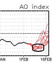
Mm... I think of Feb as a cold wash at this point.. It probably has ever diminishing hemispheric cold returns by way of subsequent blocking just getting weaker over time... until we 'end up' climbed out more so then lurch. I've noted over the years of these SSWs that when they did in fact become exertion events/coupled strat/trop interfacing and blocking, PV breaks down ...initiates mid troposphere height rise ... ( ooph sorry there) that it doesn't like .. ever end on a dime. It dwindles...torturously slowly some years. Particularly if it's an SSW and subsequent AO response all bundled up in February proper ... May as well cash out on any summer hope until July! But this year was early January. Since its ever apparently proving a coupled variant post propagation and all that junk ..we can tentatively go ahead and assume this nadir, ...is re-surge related, and that those ending members (subtended right) are too quick to run that out to neutral... My guess is those correct more toward some hillier climb out... We'll see. But I "think" with the La Nina in constructive interference with HC, when this exertion attenuates we may cross a threshold and go warm in March. Y'all know me, I'd love an 80 F March and early green-up... but, I'm not going to sacrifice objectivity for personal druthers - that's got me in too much trouble with woman and I'm not about to give the same proxy over my soul to the wicket bitch in the sky
-
Isn't that a country in the middle east ?
-
Truth be told ...if this thing does crank through a moderate showing ... we'll most likely have one or two or three cycles between now and Sunday "kick-off" where it looks like the game's going to get called by "compression pandemic," but the thing ends up airing anyway - Anything to not get the drug ahead of time, but still get the storm - lol
-
early panic in the run bleed out is under way hahahaha
-
Oh right - duh ... heh - sorry Forgot about this product. Yeah, so...again, like the GEFs - the spread appears to be over the NW arc. Man, that'd be a hoot: that 975 mb near Cape Ann - The thing is we actually want to watch the SB ...not just having to know the SB in airing while we're in the dark cuz a dystopian cryo bomb's going off in the area.
-
?? ...in any case, it is - but I'm wondering ... the flow is fast, but does that mean the atmosphere "recovers" equally as quickly ? I mean, I realize you're just posting what it shows, but .. let's say the 7th gets even a more prominent as an event, it will sweep the b-c zone well S-E and probably that 9th then gets dealt a disservice - so to speak. We may be looking at lock-in-step trade off, where we want the EPS mean to get NW more ...and if/when she does, she'll show less for the 9th ?? Wouldn't be an issue if we weren't talking two distinct events at less than 48 hour window... That said, wasn't the 1996 Dec double-trouble event like this? I'm not claiming analog or nothin' - that was unusually short turn around. So we know under the right circumstance we can't work it out. That'd be amazing - holy shit... cuz, we had like 4-6" off a regional positive bust, then 10 to 16" 30 hours later... Preeeety sure we're heading into Sunday with 80% of present snow pack in tact - That would be almost comical - 5 weeks of maddening nothing over a bare ground, then we're sitting 30" on the level boom