Typhoon Tip
-
Posts
44,215 -
Joined
-
Last visited
Content Type
Profiles
Blogs
Forums
American Weather
Media Demo
Store
Gallery
Everything posted by Typhoon Tip
-
Bingo really ... I mean, add up all those occurrence of lag, it makes the climate "line" ( I'm calling it that but's amorphous in reality ...) reflect, (lagged events) /N-terms. But it's not just that ... I mean he's right about our damming thing. That forces/intensifies the b-c gradients, and with the cold sides getting a topographic feed-back helping to keep barrier jets going, ..it's kinda more than just WAA/ isentropic lift over a cold domes. It turns WAA sceanrios into CCB ones some times.
-
Will's right there - I mean ..when I was musing at length between Ray, I was dancing with that notion in mind - perhaps could have put a quick turn of phrase in there. Like, " not including local studies" lol. That would certainly account for notwithstanding uniqueness. But it can't last forever of course. But it is true, we can offset the climate migration. It's almost like the line sags E of greens and hesitates while the inevitability of it's migration continues N. Such that ... ( purely hypothetically: ) if it took 30 years to get to ALB, it might take 38 years to clear ORH. ..something like that. I think it is interesting to note ( also ..) that our "flop direction" appears to be on the warm side in marginal modeling. It used to be that I - personally - could count on correcting a +1 C at 850 early March blue to -1... Now it seems that can't be assumed. ..separate sort of behavioral observation I've been making.
-
Sunsets are beautiful.. where are the clouds in a "Cloud - 2021" thread.
-
Occasional Thoughts on Climate Change
Typhoon Tip replied to donsutherland1's topic in Climate Change
I'm a coveted fan of the hook electrodes up to testicles tactic. It can be a very affecting management tool in that kind of perception based hurdle ... We just have to get people linked up between Climate Change, and Humanity's induction of it, before we supply the charge. People would be amazed at how quickly resistance evaporates when their nuts are connected to the crisis. Extending the metaphor further, existing inside the addling, complacent affects of the Industrial convenience bubble, denies that circuitry and instead soothes said testicles when the opposite is really needed. Again again again ... if CC came along with more corporeal ( i.e., 'can actually feel it' ) advocates, it would trigger response. The soft ramp up spanning 50 years routine ...egh. Albeit instantaneous relative to geological time span, I become increasingly convinced ... purely by observation of a Global zeitgeist in the matter, that is still just too far and long outside of the human capacity to link much. Most resisters believe, perhaps at both unconscious and in the conscious components of their psyche, that it isn't real. Duh. But, why? I circle back to that post I made in 2019: 'People deny because they can' ... which at a more fundamental level they are not connecting the problem between the environment, and the ways and means of their daily trappings and preoccupying lives have to it. They are being told, 'You can't do the latter any more, or else [ ] That's what they see. They see this, [ ] Here's my wild notion: Intelligence is not evenly distributed - as much so... - among human beings as it is in various other species. Cats, for example, are closer to one another, than human Joe is to Mary ... and Mary is to Jane ... and Jane is to David ... and on and so on. In the former, you have a group of cats, one or two may figure out how to open doors by leaping to the handle and doing 'whatever that was in estimate' they saw the human do, but most of them can't make that leap. In human beings, that gap is the difference between self-soother's walking down the street in heated debates with the ether, versus those solving the fundamental secrets of the God equation. More over, ... 50 ... 60 ... 80 ... of all people, probably fall in interquartile density that is ... well, dense. Too much so to even have prayer in saying anything that offers mystery and intrigue to those moving the variables around in the mathematics of the proverbial formula. The disparity among humans as the walk and carry on about the Earth is staggering in proportion to even Chimpanzees. When you subject these greater numbers to a multi-generational, institutional assumption/entitlement to so much... I mean, there is a catastrophic layering problem really. You have to first get people re-educated about what they are being given, then, they may start to connect with the fragility ...and ease, they have no idea there is between them an loin clothed, gang raped, starvation in dystopian pestilence, which would probably be a generation or two in length before the return to lever and donkey power regained any semblance of civility. But I'm wondering - LOL... SORRY. I'm being perhaps a little overly hyperbolically dystopian here - yes of course... I mean the numbers and dire aspects of all may in fact be better than this portrayal. But we are so close to the point of no return... we have to also be proportionately daring in our prose, too. I think of this rigor in society right now ... really a kind of "soft" ideological civil war, between vaccinated and unvaccinated. More and more, ..the accounts of the latter, where in a room of beeps, pumps and tubes, the ill-fated can only text through intubation, 'get vaccinated' ... and now they understand!? The word "Pandemic" only applies to the part of civility that is not vaccinated - this is incontrovertibly true. Putting in bluntly, ... if you are dumb, don't understand science, and concomitantly with lacking that ability...tend to be easily beguiled and manipulated by plausibility without sensing the lac of probability in most matters ... ( long sentence but bear with me - ), you're succumbing at a very high rate right now. I refer to the Delta shit as "Darwin Variant" .. .because, it IS an exquisite example of a Darwinian example. It's not really even complicated. It's a direct indictment. When a solution is offered to a group of people, an opportunity to save themselves ... but they lack the ability to recognize its salvation .. they die. I mean, if we wanna look at the underpinning philosophy ... our biggest strength against time and the forces of death that really more precisely define the Nature of the Cosmos ... is that we were given the gift of intelligence. That is our tool. Our weapon against the beast... If people are not smart enough to use it they get removed from contention. Period. Different concepts entirely ..but with root causality in utter limitations of perception and capacity guides why both problems in their respective arenas. -
Yup! This was/...is being covered extensively in the IPCC special publications for anyone else that's interested... No sense in me posting a bunch of links as one can easily load Duck Duck Go or Google, ... or whatever search engine it is you use that allows the NSA - corporate oligarchical arch to spy on your colon, ... and just type IPCC special reports and be creative and they're all right there.
-
I am not privy to your causal ideas, so.. with all due respect, they may be entirely correct. But, I have heard the 'still more snow' narrative ... just out among the scuttlebutt of Internetium in deference to the warming world. It may just be a race in a sense. Obviously, (warmING + water) arithmetic cannot interminably payout dividends - at some point 'more' will will likely be rain. The discussion is really boiled down to the million dollar question of, 'when' does that threshold happen? Yeah...I don't know. I don't know if it waits out our lives... It certainly could. There are offsets, like the solar stuff. But also, if some completely unanticipated random thing, like a volcano ...whatever. Beyond those, I do know enough not to count on assumptions. Further musing: During all these 'yeah but, it's meant more snow' ...drop the mike, walk away moments, has anyone been considering rain? Have those occurrences, both frequencies and amounts, also increased relative to climate? My hunch is ..both snow , AND rain have increased.. I'll explain below. Firstly, I have observed several winters in that 10 years that likely resulted personal lowest 10 snow totals in my life; and that includes being existential to the sorest butt of all 10 years: the dreaded ass-machining 1980s. My point, lost in that crass vulgarity ..., is that it seems "extremes" really more fairly describes the real portrait of the last 10 years. But the snowstorms contained, ... there's also a known physical-climatology for that, having to do with PWAT richness in a warming atmosphere. When it snows ( ...or rains) it is doing so heavier, everywhere - regardless of season and phenomenality. Think of it this way ( just writing this for the average reader here - ), ever heard of a "transparent cumulonimbus"? I've seen these. They typically happen on very hot summer afternoons... where there is are large dew point depressions, but ..still having enough marginal theta-e/CAPE to sustain adiabatic build. You end up with cloud turrets you can see the blue on the other side, straight through. They often don't produce any rain, but there may be a wind associated, because there's -CAPE restoration/outflow. The mechanics of the atmosphere that ultimately produce precipitation will carry on with different masses of condense-able water; in the same vein, it will over produce when the machinery carries about in the presence of an abundance. It all depends on PV= NRT's constituent variable values and what is being restored across the "=" sign in order to balance. A:(PV= T) interacting B:(PV=T) ( of the form which negates condense-able heat storing WV), also caries on in the atmosphere. The physics of the mass part effects the other variables, and vice-versa. Marvelously proficient migraine induction begins there lol. So ... this is the gist of why weathering events are precipitating harder. Simple terms, more water at the disposal of atmospheric processes. I probably should have mentioned 20 originally because statistically, with temperature and precipitation as major climate metrics, 2000 or so is about when the inflection took place the increases along CC accelerated; it just became more noticeable in the last 10. I bold the former statement, because when any system is accelerating, any 'linear' assumption becomes logically false. The term "acceleration" is the gremlin in all f-ups. It doesn't mean a forecast based on linearity will be wrong - but if right, it is likely right for 'getting lucky' I see the last 20 years as being almost spot on predicted by some of the earlier climate impact studies done/printed way back in the 1990s, btw. Not sure if anyone remembers the older mantra but it was about 'extremes' That larger variances cause bigger short term impact results, where the base-line may move more slowly. That is precisely what the world is suffering,... with 'synergistic' enhanced heat waves, the acme of which seem beyond the input terms, like the Pac NW... Or intercontinental air/land relative velocity speed records sending LGA to Hethrow in 3.5 hours because the high level balanced geostrophic velocity rich environment is already moving at almost 1/3 the speed of sound... We keep getting gradient patterns/ and looks ... regardless of ENSOs, which the greater ambit of the field spectrum ranging climatology and operational weather forecasting ... appears to be supplanting the effectiveness of ENSO, anD even MJO'S, from evincing as much forcing. I've personally proposed that HC expansion is subsuming the trigger gradient latitudes to the point where they can't integrate as much ... we'll see where that goes.
-
September Discussion Thread: Bring the frost; kill the bugs.
Typhoon Tip replied to moneypitmike's topic in New England
Funny yeah... When I read about NE PA 'tornado research' mission, my first fire-off of internal snark monologue was how said mission never has to leave the parking lot - so it wouldn't in fact be much of a financial allocation to any such research. heh. 'yeah, go ahead; knock yourselves out' -
All of them are... Hard to say what that is out there if just being model-reliant. I think the present now's argue that it is purely tropical for starters... Has to be. There is no source of dry air/non-tropical vertical thermal plumb along any radii within what is clearly now evidenced, a closing circulation. There was a bit of a weak TUTT in the vicinity up until 2 .. 3 days ago, and either a wave or a self-sustaining convection contained sort of 'out lasted' its decay. And now in addition, there are CU fractals/structures moving curvi-linearly toward the E, into that N-S stationary wall of CBs, indicating there has to be a lowering pressure in the center of that mass whether NHC believes it or not... That's probably it. If it keeps up with lowering shear and improving outflow, what's to stop. And when it goes, not sure I see what the mitigating factors are/reticence by the models. I wonder .. The models may not even know it is there yet. I wonder if what we are really seeing with the general consensus for broadly constructing, shallow circulation ...or even an inverted trough, is/are based purely on exhausting numerical instability/favorable kinematics off the EC. In this sense... until they are forced to see a materialized cyclone actually existing in the initialization nets, then we get the coherent nucleus finally. This could be a candidate for a sampling mission.. The present track of this would-be cyclone, as of now in the models, appears to really be tracking along with the WAR circulation between the lower sigma and pehraps beneath 700 mb trajectories. But a deeper vertically integrated system might not follow those stream lines and may end up steered more E anyway. Hard to say.. but looking at the Euro and GFS orientations, the 500 mb is moving more N out along 70 W, but then turns in time and exits ENE trajectory by 72 hours so .... Maybe spending this time typing more out of virtue to the science of it, versus much risk for anyone ... heh. But, if a system develops and does get more prominent it can change the sounding, one, but either way, if that development occurs and it pops N of 35N prior to 70 hours, it could come further W before climo sends it to the grave. So lot's needs to roll off the dice here ..but that 'seems' to be the deal with this thing - I'm sure another analysis out there disagrees.
-
September Discussion Thread: Bring the frost; kill the bugs.
Typhoon Tip replied to moneypitmike's topic in New England
This ... That is the last cheating attempt by the models of a summer that taxed heat for us using seemingly invented idiosyncrasies ... before they then begin the falsely snowing on D10s for the next month. -
I'm not sure we can say "long after we are gone..." in the fairest of spirit, when the effects of this shit are already observable. It's been fu ing up the winters for 10 years man. It might be be time to start owning it, heh
-
Some ensembles still trying to Bob the EC -
-
September Discussion Thread: Bring the frost; kill the bugs.
Typhoon Tip replied to moneypitmike's topic in New England
There are two variables that play in there: A, heat source and sink thermodynamics. B, source of heating Bottom line, uptake of solar heating cannot fall below the rate of the black-body radiative hemorrhaging. A, if the surrounding medium's heat sink is deepening, like lowering DPs ... seeya later warmth. A warmer DP sounding medium naturally means a shallower sink, the water doesn't hemorrhage as much. There probably is some critical angle the sun falls beneath where it doesn't matter, and the pool will cool either way. But a warmer DP early autumn may slow that some. -
You guys need instant gratification ... jeez. Problem with modeling and extended favorable regimes ...if whether/even having specifics to monitor therein, is that you have to then wait a week - it may take ...days over days before there is 'excitement' It's like people lose sight of that, and two days and a couple of banal solution cycles later .... either forget that it's still out there, or because they aren't getting fun right now ..they flop like a five year old and have these "micro" melts..
-
what does "lg" mean in that context - start there
-
We've all got our run-ins with absurdo-turbo-snow rates. Three in my life. Two are tied, and one is a short 2nd behind. In both 1997 Dec 23, and 2005 Dec 10, I witnessed 7 inches in one hour. Both those occurrence were also book-ended by a couple of hours of 3 or even 4"/ hr rates, but ... once you've suffocated in a 7" hour it almost seems like 3 is light snow. Whole 'nother world when approaching the coveted 5 per hour rates. The other time was early February 1986 ( '87 ?...for some reason I can never remember the date on this one ). 5.5" in one hour fell in dead air, also book-ended by 2 or 3"/hrs, before a coastal finally kicked-in a CCB that put the final nail in the forecast coffin that it would warm up. This one had lightning and thunder ... I was skiing Nashoba Valley over here in Littleton when that first 2" snow-hour abruptly swept over the mountain and suddenly ... 1 mile become 50 feet visibility. 20 minutes later they closed the slopes because a double-flit pulse of blue light preceding seismic chest thumping booms - uh...yeah, get people off the lift towers, now! There were several thunder claps over that 5+" hour. That was a fascinating storm. One of those storm-memories that never fades. Totaled close to a foot off a forecast for 1 to 2" then light rain and mix. I hold this one as close to heart as the other two above - even though it's in 2nd place total-wise it shares the ceremony. This thing came on utterly out of nowhere ... To go from almost an ignorable weather forecast windshield wiper expectation, to a traffic-grid failing, deep winter storm realization is pretty f'n awesome. My father said that Rt 2 there at Arlington Heights ..the big climb up the hill out of Cambridge ...was a parking lot of cars fish-tailing but not actually making much headway up the hill. Somehow his pick-up made. Earlier that afternoon, ..around 1:30 ... the temperature was like 21 F when the snow started with those insidious tiny uniform aggregates of plates and micro dendrites. Like the menacing needle eyed hurricane. Small sometimes means BIG! I remember standing there in front the window as Algebra 2 was gathering when the teacher sided up next to me. I said, "It just looks cold." She says, "I don't think this is turning to rain" .... heh, good call. I just don't know if these kind of bust can even happen anymore ...although 2005 was not terribly forecast to be fair. But obviously, it too over produced in drama ...what with 110 mph trop. folding p-wave winds straifing the Cape while Metro West was blinded by snow falling at 50 dbz thundesrtorm rate... It was still totally AWEsome! Anyway, as much as we like to make fun, it does seem the bigger gapped busts are getting rarer, because the models may be just good enough. After these.. I've seen 4" an hour probably more than a dozen times in my life. I've seen in it Lake Effect in western Michigan but ..that's technically meso. I think there is a steep probability curve at that mass, perhaps. Like it gets into that realm where excessive outputs are, perhaps counter-intuitively, relying upon such fragile constructs or something that they too often fail to set up and you have to "settle" for 4 -
-
September Discussion Thread: Bring the frost; kill the bugs.
Typhoon Tip replied to moneypitmike's topic in New England
To be fair ... I am not sure that it is mine, per se. But I get what you meant... I am not sure which came first, my bloviating, or whether reviewed/officiated science on the matter was just happening all along unwittingly to myself - probably the latter. With millions of minds looking, pensively peering over environmental facets these days ...very few novel ideas are really out there. It's more of race to be published first, while half their reader's are all going, "Yeah, we know/knew this 10 years ago... " But the point is, it's saturating content everywhere. Most respectable enthusiasts, to normal climate and Met folk alike are aware. Although personally, I don't know, nor have read any formal "transition season"-attribution studies. Like the fact that snow in October was perhaps a 1::15 year ( Will ? ) return rate prior to 2000.... since then? IF just taking these 21 years, it's like 1:2 That's either a shift in climate...or one heluva repeating fractal in the vagarious noise of climate. K, so - having said all that, re the 2nd bold sentence. The short answer, no - there is no requirement in that sense? +2 is based on a climatology that spans previous decades, prior to the present and/or future climate, which are by all evidentiary empirical accounts and mathematics after those facts, sloped up ... means that we are inherently at risk using past climate to assume anything like a 'balancing' - for one, we don't know where the base-line is in a moving foundation. We have been getting the autumn snow oddities. We have also been getting weird, deep May CAA events too. These prolapse and lapsing cold season phenomenon - I suspect - can be attributed to HC expanding. This expansion then "triggers" velocity soaking in the mid latitudes earlier than normal - and with faster base-line wind velocities in the middle Troposphere, that is going to ( by geo-physics ) materialize coherent R-wave distribution ... This precedes patterns that are capable of delivering cold early, and late, relative to a slow hemisphere. This than has been doing weird aspects to the mid winter months two - DJF. But that's another topic. -
September Discussion Thread: Bring the frost; kill the bugs.
Typhoon Tip replied to moneypitmike's topic in New England
Lol, true but...there are other reasons humanity can and do stupidly place official thermometer houses/ob sites where they do - it doesn't have to be airports per se. Frankly, I'm not sure why - anywhere for that matter - these temperatures have to be out around those civility escapes. Obviously more usefulness in climate science. -
September Discussion Thread: Bring the frost; kill the bugs.
Typhoon Tip replied to moneypitmike's topic in New England
Yeah to each his/her own... Bottom line is, I have a lot of patience for 40 to 50 drab weather in Autumn than I do not for that kind of weather in April. And in a way ...although I start getting excited for snow as Octobers move on, I also have patience for warmth/Indian summery fare as well, just because we have winter still coming, either way. That's basically it. If we wanna break it down further, ...obviously it's situation-relative. Like, if its 44, gloomy cloudy slate skies on Sunday at 2:14 pm on Nov 13, and the models have an interesting scenario with hints of cold profiles waiting for Half Time scrolling, that 44 almost seems charming - lol... But if it's May 3rd, and green up is clearly 2 weeks late and we're on the verge of chopping down solar max days with it, that may as well be rectal plaque. -
September Discussion Thread: Bring the frost; kill the bugs.
Typhoon Tip replied to moneypitmike's topic in New England
That Worcester one there ..that must have been before the 1K move up the ladder. I don't see that altitude doing those dates when we cannot hardly ever get July to do that there. Just guessin' -
September Discussion Thread: Bring the frost; kill the bugs.
Typhoon Tip replied to moneypitmike's topic in New England
Curiously ... where did you find these ? heh... -
September Discussion Thread: Bring the frost; kill the bugs.
Typhoon Tip replied to moneypitmike's topic in New England
I dunno - I like those nostalgia afternoons though, from Oct 20 to Nov 15 or so... You know, where it's 44 F with sloped tepid sun in between virga blobbed CUs passing near-by, that send spritzers of cold rain drops along with those teeny packing pellets. Not enough to wet the air or Earth, but in the air. And it's accompanying the deodorizing polar air aroma that we come to recognize as that 'smell of snow.' Completing the picture, while doing the particularly loathsome chore called raking, the wood smoke curls around the stacks to add some cinnamon to the air. Baked chicken and mashed taters with gravy .... Or, en route to crew with dudes for b-wings and Patriots games ... In either one of these two settings, knowing you have 3 or 4 months of winter weather phenomenon to switch gears finding inspiration. I don't like that packing pellet days in early May, no LOL. Maybe those autumns are gone forever. After that shit show yesterday, the Pats part of it may not contribute again - haha. But also, I think we are in trouble for those 'transition weeks' anyway. It is hard to steady state the seasonal migration when we have this CC stuff more and more so proving to be a disruption on circulation structures and pattern this and that, when trying to move the hemisphere colder. It seems it's like 70 F or ...advisory snow. -
Yup, that NE Mass action came over/down Rt 2 straight down the Mohawk Trail just prior to dawn, and we got popped with I'm guessin' .5" in 15 seconds. LOL, but though rain seldom wakes me up the roar of it this time, did, and sounded disturbingly rumbly heh. Really fast, but drowning rates. Only two flashes. One was typical crawler, but one must have been a positive stroke judging by the acoustics of the report along with it's ability to resonate the structure of the home.
-
September Discussion Thread: Bring the frost; kill the bugs.
Typhoon Tip replied to moneypitmike's topic in New England
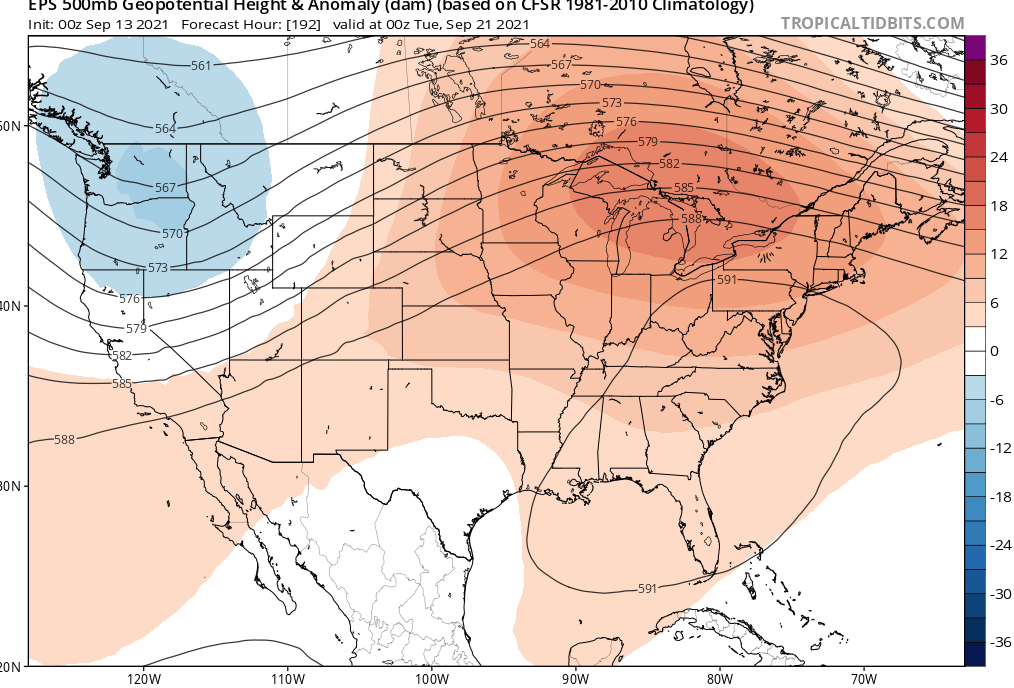
No shit, man - I just saw that 192 hour look. this, is anchored so deeply in every statistical inference method there is it'd need a planetary root canal not to succeed. But it's not just the y-coordinate of the non-hydrostatic height field, as it's rollin' through the OV/ southern Ontario. I mean that's probably only 1 or maybe 2 SD in actual vertical anomaly. It's the 'longitude' of that wave structure/ x-coordinate. It's very massive in that west-east aspect. That thing is like a tsunamis wave out at sea, where the energy is all in the lateral, such that when it hits land it piles up ... and become vertical? Sort of a metaphor for the real surface temperature potential. A more "intangible" aspect: with so much ballast in the 'length' aspect of the larger synoptic wave, that means it is got too much momentum and will likely need to degenerate over longer time. In other words, that's not looking like just a 2 day misty warm sector there. I mean sometimes these dramatic warm signals ... particularly post August 15's, will tend to over balloon ...and then the westerlies come along and dictate them as short duration warm sector intrusions ... etc. But that really looks it has a pretty solid and confident chance to be more than that.
-
September Discussion Thread: Bring the frost; kill the bugs.
Typhoon Tip replied to moneypitmike's topic in New England
Maybe I'm not searching right but this is actually not so easy to find. Trying to find the 'latest in a calendar year a heat wave took place' ... etc, but it's not apparently a very popular observation - -
September Discussion Thread: Bring the frost; kill the bugs.
Typhoon Tip replied to moneypitmike's topic in New England
Except you'll be in the 80s ... but sure. Well okay .. .if your hangin' out with Red Tail hawk aeries up there above 2K elevations ... sure. But this is everyone S-E of the ST L. Seaway bathing in a deep, homogeneously (through the vertical integral) warm anomaly. I bet its positive anomaly from 200 mb all the way down lol.. I also think DPs will be too high to shed temperature that much at night - even this late. Might be interesting to test the seasonal dew ringing, vs the (CC + pattern anomaly)/2. I almost visualize morning's so dew that the soil beneath the feet get real watering and small puddles form in the gutters.