

Typhoon Tip
-
Posts
44,565 -
Joined
-
Last visited
Content Type
Profiles
Blogs
Forums
American Weather
Media Demo
Store
Gallery
Everything posted by Typhoon Tip
-
December 2021 Obs/Disco...Dreaming of a White-Weenie Xmas
Typhoon Tip replied to 40/70 Benchmark's topic in New England
Starting to wonder if the only way one of these models will ever verify snow coverage is if and only if every last mother fer fully believes otherwise. -
December 2021 Obs/Disco...Dreaming of a White-Weenie Xmas
Typhoon Tip replied to 40/70 Benchmark's topic in New England
Weather modeling will never get around the quantum uncertainty principle; that is the computational dead end … which means the future emergence at scale will always have some fraction of freedom from prediction. -
December 2021 Obs/Disco...Dreaming of a White-Weenie Xmas
Typhoon Tip replied to 40/70 Benchmark's topic in New England
Watch NYC get 2" Xmas eve and SNE gets nothing and likes it - -
December 2021 Obs/Disco...Dreaming of a White-Weenie Xmas
Typhoon Tip replied to 40/70 Benchmark's topic in New England
It's actually a stronger, more evolved sfc system - actually approaching bombogen criteria on this NAM's 18z Not sure I see less amplitude there - unless some other metrics ? One thing it is, is more nucleated and concentrating a core. It's almost like it's maybe confusing this into a TC ...I wonder if the phase diagram/comparison between it and the 12z might show that. -
Occasional Thoughts on Climate Change
Typhoon Tip replied to donsutherland1's topic in Climate Change
I've often wondered how sci fi it really is to speculated a mega displacement event - no sense describing what is meant by THAT. Little known ... I read or heard a story someplace - the age old cry of the rumor mill LOL, admittedly - where climate stations owned by different sovereign origins, situated out over the expanse of the Greenland ice cap - but as typically the case, are in comm's relationships with one another pretty regularly ... - all experienced an "Ice quake." Ice quakes are not altogether that unusual, in and of themselves, but having them all experience the same description, at the same span of minutes, within the same hour, stationed 20 or 30 nautical miles apart, is either an extraordinary act of coincidence at massive scales, ...or something else was taking place. Later that day, they started failing direction finding tech, because their coordinates were all off. Tapping devices, giving shakes ..maybe the batts are low..etc. Turned out, all three stations ... including the ice they were anchored upon, up and slid some 1/4 to 1/3 of a mi. But being situated out over the open expanse, where by there is nothing to differentiate against any horizon fixtures, they were unaware this was happening, the were actually, en masse, in motion. Other than the rumble and shaking going on as they moved. This was later attributed to increase basal flow rates lifting and "lubricating" the glacial foundation, and it lost anchor footing temporarily and away she went. It stopped... obviously. But this business with the "Dooms Day Glacier," as the press has come to denote, kinda hearkens to a similar scenario. I haven't dug in - just on the surface so far... Only here, the water ice that was essentially holding the land -based ice, has always preventing that. All the recent calving events having taken toll of the interstitial integrity of the mass "damming", ... maybe something like a catastrophic displacement nears a threshold. And the one that 'rumored' to have begun and halted one fateful day in mid summer over the vast expanse of Greenland, could take place. Only in the case of Thwaites, it doesn't halt. I think that fear must be implicit in this, already. -
Occasional Thoughts on Climate Change
Typhoon Tip replied to donsutherland1's topic in Climate Change
Shortly put, 'make going green a profit wagon,' somehow some way, and the world'll become a "Pandora" utopia ...really fast. -
December 2021 Obs/Disco...Dreaming of a White-Weenie Xmas
Typhoon Tip replied to 40/70 Benchmark's topic in New England
This is sorta interesting... look what's packing into the almost cookie cutter same region as that record heat last year - those are minus 30C contours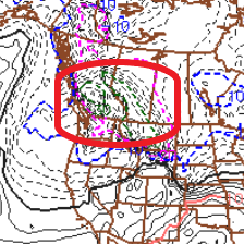
-
December 2021 Obs/Disco...Dreaming of a White-Weenie Xmas
Typhoon Tip replied to 40/70 Benchmark's topic in New England
Not sure who said what when and where, how, or in what context so all due - but that idea of more than less favorable pattern transformation taking place closer to the month's end is definitely showing up more so in the last day's extended cluster means/telecon derivatives. Long ass haul to get there of course.. .but, we'd be out past the break water of the holidays in the open winter sea where it's all about pure event tracking for its own merit. -
December 2021 Obs/Disco...Dreaming of a White-Weenie Xmas
Typhoon Tip replied to 40/70 Benchmark's topic in New England
why I said it... heh -
December 2021 Obs/Disco...Dreaming of a White-Weenie Xmas
Typhoon Tip replied to 40/70 Benchmark's topic in New England
Pacific flow ... or which ever, yup - I just prefer to refer to it overall as a 'gradient rich' environment. By gradient, we mean the height contours on the weather map. When you see more of them, the ambient wind velocity - to wit, waves in the atmosphere move embedded in that field - increases in direct proportion. This is a circumstance - as an aside - that has been a repeating theme in winters over our continent, with increasing frequency observed since the early 2000's. This has happened regardless of ENSO this, or PDO that, or polar index multi-decadal indicators. Prooooobably related to the 'hocky-stick,' non-linear climate change. -
December 2021 Obs/Disco...Dreaming of a White-Weenie Xmas
Typhoon Tip replied to 40/70 Benchmark's topic in New England
Actually ... that's sort of the idealized model you have in mind there. It's not 'theoretically' wrong to outline a theme that way, but nuances relative to circumstance - long words for what this coastal is actually doing ... - is what fills the pages with the real story in each case. In this one, you have a low that moves from a zygote position E of GA to western NS in 24 hours ...that's ~ 85 mph of cyclone translation speed. That is unusually fast. The wind on the west side of this thing - even in a fuller strike - might actually not even be all that impressive due to that vector addition stuff ( think coastal accelerating hurricane, west side lower wind ..etc.). Simple words: not enough time to "grab" air in that sense. -
December 2021 Obs/Disco...Dreaming of a White-Weenie Xmas
Typhoon Tip replied to 40/70 Benchmark's topic in New England
Heh... 'cept, I don't really feel it's me doing the twisting? I feel more like an investigative reporter, ...disseminating ironies just comes from honest observation. The models are - figuratively of course ... - going out of their way to find a tribe in east Africa and then taking their sandwiches - ..ah, we'd be the tribe in that metaphor. -
December 2021 Obs/Disco...Dreaming of a White-Weenie Xmas
Typhoon Tip replied to 40/70 Benchmark's topic in New England
That ..and I was also just mentioning to Dryslot ( I always feel so dirty when I say that person's handle - ) how the NAM has a NW bias in this time-range and track. The GFS did sort of coalesce the low sooner and a few clicks west so.. heh, we'll see. Even in a stale fart air mass, I bet if that came down hard enough it would got slushy parachutes. -
December 2021 Obs/Disco...Dreaming of a White-Weenie Xmas
Typhoon Tip replied to 40/70 Benchmark's topic in New England
Yup... and to add to that suspicion... as I have my self warned when not mocking, ...hundreds of times, the NAM has a consummate W-N bias over the western Atlantic beyond 36 ... 48 hours, which this fits squarely into that suspect manifold. Despite that tho, this southern streamer is a specter that's been on the charts whenever grousing and bad attitude lenses allowed the user to see it... the 22nd system. The question - as Will and I mentioned - was really whether the N-stream would be able to 'dig' more and capture it/ up the phase proficiency. It's a fast flow - models don't handle the delicate machinery of phasing when hurrying the flow along at ludicrous speeds lol... ( I think I'm all set and ready to move on with fast atmospheres after the last 10 few years, but I fear it more common than not going forward ) Anyway, the GFS did also bump NW a bit ...clipping eastern zones with 34 F rain drops - Truth be told, if this thing were to really just come more W and dump heavy, it probably parachutes, but grazing the region in a rotted air mass is the shits. -
December 2021 Obs/Disco...Dreaming of a White-Weenie Xmas
Typhoon Tip replied to 40/70 Benchmark's topic in New England
Well that's smacking the faces of the already crying ... ...12z NAM with a 980 RI passing over the BM re the 22nd thingy... only - too warm. wah wah wahhh -
December 2021 Obs/Disco...Dreaming of a White-Weenie Xmas
Typhoon Tip replied to 40/70 Benchmark's topic in New England
Assimilated data seems to do this … then the mains roll and it backs off -
December 2021 Obs/Disco...Dreaming of a White-Weenie Xmas
Typhoon Tip replied to 40/70 Benchmark's topic in New England
Heh ICON’s 18z clipped eastern zones with cat paws from that old 22nd thing -
December 2021 Obs/Disco...Dreaming of a White-Weenie Xmas
Typhoon Tip replied to 40/70 Benchmark's topic in New England
I suspect they’re just framing their outlooks with persistence in mind. Until something breaks toward a verification that at last validates all theses -so far- empty indications … can’t really blame them if that’s the case -
December 2021 Obs/Disco...Dreaming of a White-Weenie Xmas
Typhoon Tip replied to 40/70 Benchmark's topic in New England
We’ll … the probabilistic upshot of that is that D10 GFS deterministic solutions are usually determined NOT to successfully take place. I posted that for fun btw - -
December 2021 Obs/Disco...Dreaming of a White-Weenie Xmas
Typhoon Tip replied to 40/70 Benchmark's topic in New England
18z GFS scrubbed the launch for the week after Xmas now, too LOL... Tries to bridge the -NAO with the S-SE positive anomaly, right over our skies ... -
December 2021 Obs/Disco...Dreaming of a White-Weenie Xmas
Typhoon Tip replied to 40/70 Benchmark's topic in New England
Funny you mentioned this .... I have been wondering if/when the model dailies might start showing something like that -
December 2021 Obs/Disco...Dreaming of a White-Weenie Xmas
Typhoon Tip replied to 40/70 Benchmark's topic in New England
I don't - still - think the Euro is going to win taking a low NW of New England, *IF* the -NAO is western limb oriented. That's physically less likely.. The model will likely not have done that anomalous behavior last night and this morning's cycle, if it didn't wash it's 120 hour range with amplitude like it always does... after which it then has to 'conserve it's own invention' So a little snark there, but heh... no - It can happen, but it's too rare and not likely handled at this range. The NAO is the wild card - it's a fickle beast in the models. -
December 2021 Obs/Disco...Dreaming of a White-Weenie Xmas
Typhoon Tip replied to 40/70 Benchmark's topic in New England
I'm not sure I agree with this statement though, "snow/cold freaks enjoy the negative side of life and outcomes..." In a vacuum I definitely do not; the end of the sentence does not follow logically from the beginning. Otherwise, I have trouble finding a context where this kind of dead-panned assumption of motivation, consigning all, can be true. Some ..in fact, most that I have ever met, Meteorologists and weather enthusiasts alike, are drawn to drama first - not people flying through the air, nor property being shredded off foundations. There is an important distinction between the draw, and taking say ... 'schadenfreude' when observing harm unfold. The draw to drama is entirely ( by the way ...) a survival instinct. For those that do not fixate on specters, tend to succumb to them - eventually.. That draw and fascination for the dystopian cinemas of nature, to wit, the cinema of 'big storm graphics' ... that draw is far in way more having to do with that instinct - but ... people then get a charge out of that excitement and then get addicted ( in a sense... ) and that's a whole 'nother phenomenon... Anyway, much of that is often misconstrued as some form of morality failing. I'm disinclined to agree. The total motivation is nuanced, but just in general here. -
December 2021 Obs/Disco...Dreaming of a White-Weenie Xmas
Typhoon Tip replied to 40/70 Benchmark's topic in New England
Really, if you took the 00z synoptic surface evolution from D5 to 7.5 and just moved it N 70 mi, that's the only difference. It's high stakes. Lot of temp gradient along the mean boundary - does it exit? And if so, where - -
December 2021 Obs/Disco...Dreaming of a White-Weenie Xmas
Typhoon Tip replied to 40/70 Benchmark's topic in New England
Egh ... I was gonna write about it. Even considered a new thread, "Anatomy of a White Christmas," that covers the scaffolding of major atmospheric, mass field modes --> modalities, replete with annotated graphics ...etc. Then, onward to elaborating how those might parlay into better chances to Currier&Ives the appeal of Xmas Eve through Boxing Day then we may think. Alas! Will ( bastard! ) beat me to it. J/k Will.. I mean he's succinctly covered the generality, and why/how the 'correction vector' toward ( what I believe would mean ) less likeliness for a Euro wound up western Ontario low by D7. I just want to offer some more specific insights/observations re the dailies: The differences track back to roughly/beginning D5.5/6, off the 00z runs when comparing the Euro and the GFS operational version ( the GGEM is mid way between so take for what that source is by least regrets. I won't for this exercise.. ) Looking first over Ds 2.5 - 5, the flow construct is, in essence, not significantly different between the two - and for what it is worth .. the means of both ens systems don't urge questioning much either. They have an 'outside slider' type trough curling down the Cali/west Coast, turning E and probably bringing mud slides to the elevations E of San Fernando Valley. From there on the -EPO trough ejects these mechanics into the crucially different morphology. Look over lower Saskatchewan/Manitoba by D6 ... ? By then these models have completely divorced in falling diametrically out of sync with one another. The Euro has a tightly nucleated, deep negative anomaly in that vicinity, amid a negate regional nadir in the height fields. Contrasting, the GFS bifurcates teh flow west of there, with the N component ridging amid those same skies, while said ejected trough coherence cuts underneath toward Chicago... The reason for this difference isn't abundantly clear, but it has meaningful forcing implications heading in Xmas day and the 26th from the Lakes to New England ( and all of this could be move up in time, too, nodding to the antecedent persistent fast flow state that's more of an on-going corrective, endemic hemispheric footprint ). This flow type of the GFS with the trough underneath, is a progressive low-amplitude REX configuration; those typically wrought winter headaches. Despite these significant mid/upper air differences aloft, the Euro surface featuring/version actually is not hugely different than the GFS for east of BUF... certainly ALB as we head toward the 24th. Both version initially maintain a bit of '50/50' low CAA leading, and start overrunning and snowing by dawn on Xmas, but... the Euro then has huge momentum in warm sector push and ends up cold raining and clear to southern NH. But those details are all going to change of course. I suspect if the EPS/GEFs mean, which both show Greenland/-NAO node tending to move S toward the D. Straight region is correct, that is going to offer less support for Lakes transits ( like Will said. ) So I'm precariously close to restating his ... heh.


