

Typhoon Tip
-
Posts
44,566 -
Joined
-
Last visited
Content Type
Profiles
Blogs
Forums
American Weather
Media Demo
Store
Gallery
Everything posted by Typhoon Tip
-
Heh... I always thought that description best fit the EPS... which it may - just sayn' I've often found that if the operational run "looks" more(less) favorable, the EPS mean does too, in the relative scope.
-
Holy Schitchel ! He/she used to be one of my favorite mid rangers down in NCEP .... "..Arctic air will dig across the central then eastern U.S. behind the windy and precipitation focusing low to include a threat of plowable snow from the Great Lakes/Ohio Valley to the Northeast. Another quickly developing heavy snow/ice threat with some aforementioned uncertainty is on tap underneath Thu into Fri from the TN/OH Valleys through the Appalachians/Mid-Atlantic to the Northeast by frontal low/coastal storm genesis..."
-
Greatest anomaly ... relative to climo as it were. Not cold - but I think that's what you meant. Anyway, La Nina this or that aside ..that's about the best your ever gong to see 300 hour ens mean. In fact, typically by that long lead we end up with spaghetti that averages more annular looks. That's sick structure for this range ... but one with an aspect ratio, proportional to the endearing winter enthusiast, being the best part lol.
-
That's a complex answer. Lol... ( hey, consider who you're asking ) Short answer, I don't believe so. Long answer: Personally... that phenomenon you mention, I've often had 'chicken vs egg' problems with that. I think that perception has that the wrong direction. Basically, change was already taking place, if perhaps "intangibly," before it manifests on charts. Then, a storm event materializes because of and sometimes on top of the emergence threshold of the pattern modality. Here's the thing, because it wasn't coherently seen, that gives the illusion that the storm- event was the cause... It's really the other way around. So if you can figure out how to parse that paragraph of conceptual jargon out, and formulate an impression of what I'm trying to say, I'd be very proud of you... In this case, The governing mechanics of the Jan 7 system is entering the hemisphere during a pretty significant whole-scale reshuffling of the pattern. Really...from well west of the Date Line and the plastic island of the bounding Pac, ...all the way around to Greenland, today vs the 300 hour range end up bearing much less comparative likeness. That really begins to occur from Wed ...Thursday on, within which this Jan 7 deal plays its cards and quite likely gets a physical enhancement, too. "What ever happens in Vegas, stays in Vegas" ... On the other side of that Wed/Thu pattern boundary/reshuffle, think 'removing the memory' of the previous regime.
-
Right on schedule arrives the mid season break down of the leading ENSO signal ...
-
Ha! ... uh, I dunno 'bout that. It's more like the population of the initialization grid. There used to exist this "model diagnostic discussion," back when it was carried under the NCEP banner. But then it became WPC ... etc, and I don't think it's covered there? But they would flag this in discussion and surmise how it may/or not have effected the model processing. Now would be a good time for that -
-
Lol... dude we get it.
-
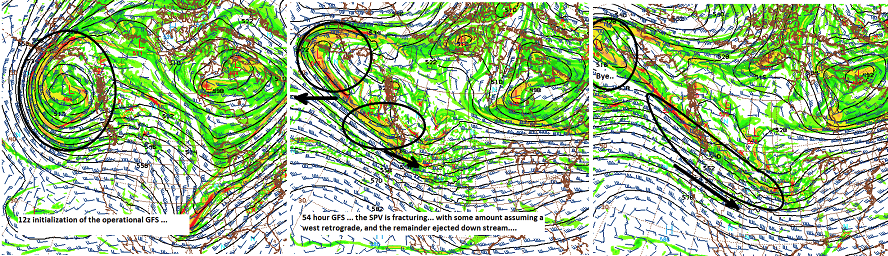
Oh... I know ( or 'think' I do - ) what happened. The American model products don't correct ( don't think nearly to the scale or degree that the foreign clusters do ) for input garbage. This smacks pretty loudly as the GEFs 'AI' gulping in back-wash initialization - it's sacked the whole ensemble mean too deeply and pervasively for me to believe this was organic. I bet the Euro negated faulty inputs. That said, I do think there is going to be some uncertainty wrt to the SPV spit over the NE Pac, and how much gets inserted downs stream. And if/should the ridge bulge in the back side, that ups the ante -
-
I'm really curious what is causing the flip flops in the GFS ...when comparatively, the Euro has been considerably more stable. Aren't we giving them the N/A input/grid. Lol. The GFS was competitive this season ( at least ..) but if this thing goes on to be a moderate or even low end major storm success, this is going to be a pretty significant indictment of the GFS' middle range forecast performance...
-
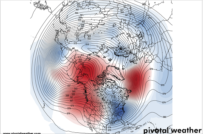
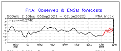
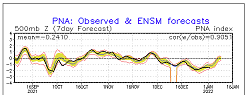
Update: Short version, the super synoptic evolution supports S/W's NOT (as much) being mechanically neutered ( negatively interfered ...) as they come eastward across the country. There is contention among the model types, and within there own continuity/handling therein, as to what and how much will actually be there. Critical time intervals to know that answer appears about 36 hours from now ( estimating - ) More details ... The S/W mechanics responsible for what was D7, now ... D5.25, originates from a rather usual source. This is not the typical trace-back to the date line, or delivery through the EPO domain ...etc, where it can be observed in WV channels and assessed over longer, real-time analysis, then balance against model performance/ initialization issues ... Being able to do that will service confidence or doubt. Can't do this with this guy... It's coming from that SPV split, as it appears to bifurcate as seen above. The GFS has been flip flopping as to how much then retrogrades west under Alaska, vs how much injects over N/A. More goes west, less goes east... vice versa, = storm or no storm. The PNA rise is still in tact in the various guidance ens means. In fact, it was well discerned yesterday... and that has continued if anything even more so on the 00z. Numerical interpretation of the GEFs mean would suggest both this system, and a one out mid month ( ...fuzzy 12th+) are on the table, due to that correction, and then modulation out in time...etc. That said, the interesting aspect is that now model in either the Euro/EPS or GEF members ..et al, really look Archembaultian about this/ .. as in a bona fide correction event. Believe me...that would make this more confident as the total scaffolding would be face smackingly clear. "As is," this appears to be a maintenance trough translation - basically normal periodicity. But, the PNA --> PNAP super synoptic considerations appear to to be more in constructive interference for just about anything for a change. Including this, and that's why we're having discussions. That said, I'm not sure the western ridge won't respond more and show some 72 hour lead adjustments that increase the y-coordinate of the arc of the ridge. It may not ... but, this is a PNA pattern change is numerically impressive...going from -2 to + .5, or even +1 SD is huge amount of implicit alteration in the mass-field distribution, and it is doing so quickly in both the EPS/GEFs. The western ridge could certainly expand more so, as the numerology of this would allow room for that. I'm not sure why we have to have this flat ridge aspect to it. It may.... "maybe" be related to the fact that there is a very modest positive bias to the outlook curve, wrt to the verification curve. pure speculation though... That's probably nit -picking and irrelevant given to the nature of that rise - it would be unlikely to error that much.
-
It's more than then just the GFS operational, tho - as was just sneaky mentioned in a brief sentence now scrolled ... the entire ensemble mean of the GEFs has lost this - all but small vestiges. Essentially ... gone. hmm ... Hopefully either it, or the Euro's EPS et al, will be 100% correct. That way we get to chide and humiliate one or the other for being uniquely abysmal -
-
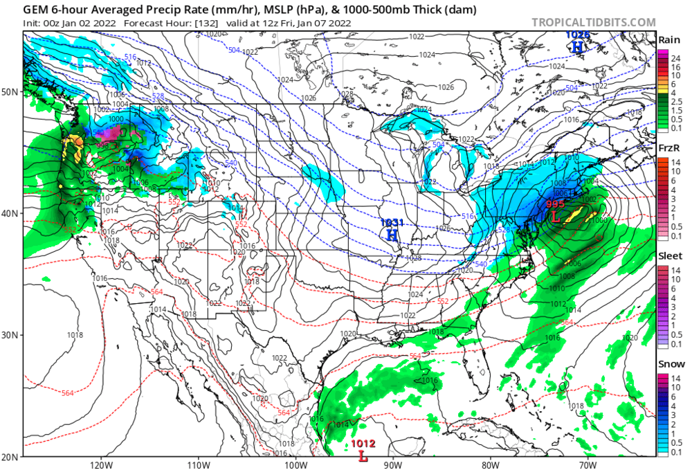
Ha. Well there’s some seasonal relativity there … yeah it’s the GGEM and outside of day 5 at that but 132 looked like it’d be better performing but the 138 hyper contracted the system into the dimensions of a thunderstorm. Jesus
-
This is probably where the Euro’s control mechanisms come in handy
-
Bottom line it’s gonna do this probably for the next two days
-
Yeah no kidding. meanwhile the GGEM destroys
-
GFS is carrying the system still. That ICON was just weird. this thing is slipping initialization
-
Wow. That may be the biggest about face in a single run I’ve ever seen. ICON is is mostly sunny. Pretty sure the 12z was warning event … heh
-
I'm sure y'all have covered this ... as we did countless times in the 2,000 page super thread last year ... but it won't becuase from cottage industry to 800 lb gorilla scales, the concept of COVID has become too industrialized. It's got a profit interest now... That's basically going to protract it - and there are enough toe-the-line population that will gladly enforce and set rules based for what has become incorporated. It is just as much endemic to our species, as it is genetic to global economy - Oh it'll switch from COVID to just riding the germaphobia that it has triggered ...
-
We just need this so dubbed 'Dooms day glacier' to go ahead and unleash the back-held weight of a small continent in ice, ...and have it cataclysmically slide one afternoon into the sea... effectively setting off a global two foot tsunamis that doesn't go back out to sea.
-
This is just an arbitrary member .. but there a lot with this look -
-
Not to turn on the d-drip and walk away but ... just got around to looking over some of those individual 12z GEF members. HUGEly improved consensus over 00z for one just in general. But, 10 or so individual members have very large snow ( yes SNOW!) totals falling in a short period of time between 144 and 156/168 hours. The storm is moving right along, but in those members, it appears enough anyway. They cross the bomb threshold, ... large QPF totals on the west side of neg tilted trough/wind max along ideal trajectory; riding up immediate astride NJ-MA. There is probably has excessive frontogen UVM banding in the I-95 collocation... probably why they are turning the moisture upside down. I mean ... not to get into details. LOL No but it is a lot of fun to see this cinema... I give you that. It's been a while since we could enjoy a good game of speculation pong
-
or those savvy I'm actually curious what the 18z Euro suite signals out there near the edge
-
For entertainment only: ... this is this thing's might without the western ridge kickback As a result of this it is consequentially moving fast - which would limit some impacts if so. Real concern: But again.. I want see what the ridge does in the model runs about 48 hours from now. We have seen plenty times in the past, the Pac forcing adjust those bigger(smaller) in the boundary of the short and mid ranges.
-
I here you! But in all honesty .. my "menace" in the ending context there was for amplitude alone ... I just don't have insight into ptype from this range - not that anyone cogent does... just sayn' again, ...for the general reader, this is a higher confidence track-able aspect,alone. We are prooobably 2 days from details in normalcy/model error climate if you will. The speed of the flow and the low arc height of the western ridge isn't helping matters, because for every radii we lose, we increase the dreaded needle thread aspect. Thing is... you could just get incredibly fortunate ( notice I didn't say "lucky" hahaha ), and have the ridge go amp while nudging east. You could successfully place a slowing bomb in just the right location by dart method It's almost scary that the EPS and GEFs essentially have the placement - we wait on the bomb. It's got a lot of power man. wow. Really. In a corrective scope, you drive the ridge in the west with lowered static heights over Florida and that thing is a candidate for exception mid level depth near the Del Marva.
-
Some quick observations I've made during the day ... The pattern reshuffle with a restructuring of the PNA relay into N/a is quite likely and legit. Entering into this new regime... we kick things off, D6/7, with coastal. 1 ... yesterday I surmised the Archembault scenario pretty hard.. However, upon really focusing on the behavior of the individual GEF members ( because my life is so fulfilling and pithy in meaning, otherwise...) I don't get the sense that is what is happening over the course of the week ... leading any would-be event on D6/7. It appears we merely have a well time, yet potent Pac injection of S/W mechanics, taking some advantage of the reduction in negative interference east of 100 W across the continent. By the time this feature nears the lower OH Valley ..D5 or so... the ridge is essentially gone..."almost" but not quite down to the climate height signal over the TV. Immediately aft of this S/W, there is modest albeit crucial .. ridge growth over the Rockies .. then nudging east, as a responses to the PNA forcing. 2 ... that ridge is key ...I really think the biggest sensitivity for how the D6/7 evolves will come down to the handling of that aspect of the total L/W space. If the ridge remains flattish... then we prooobably deal with more a NJ model detonation of sorts... If it ends up more amplified - which is a correction vector for such a steeply rising PNA index, btw ... - then we'll have to contend with future guidance trending slower and potentially deeper, with more actually H.A. look. Such a system could even find its way toward the eastern Lakes, give to the lack of downstream exertion for having lost the western limb of the NAO. In fact, the latter is positive by then. Those are my two main take aways for where things set up now. Obviously...subject to change. ...as an after ob/thought.. .that S/W is really is deceptively powerful. It has jet max over 110 kts at 500, and nearing 150 kts at 300 mb ... as it is torpedoing over the MS Valley around 96 hours. This intense jet core has been very consistent ... regardless of the total L/W amplitude and whether it gets any physical help that way. Should the western ridge pop as a future correction in guidance, this thing could become a menace.


