

Typhoon Tip
-
Posts
44,565 -
Joined
-
Last visited
Content Type
Profiles
Blogs
Forums
American Weather
Media Demo
Store
Gallery
Everything posted by Typhoon Tip
-
Hm. Probably not the place for it.. but it looks like the synoptic super structure of the hemisphere will tip cold at mid latitudes, from Jan 15 ... --> 20th+ ... onward to some open ended distance. The other aspect I'm liking is that all ens extended graphics, and the numerical presentations (teleon values) are bouncing the PNA from neutral to positive around 3-5 day periodicity. No more cellar PNA - the longer term circulation mode of the EAMT --> Pac doesn't really look like it would return. We can do that with a fast flow, however... but if the AO/NAO are legit negative, which they appear to be in the time frame, that period gets interesting. The AO is important WITH the NAO ... Negative NAOs in a fast flow footprint aren't really good for us. But with AO help, that's probably going to pull the EPO down and things get interesting. Of the two 'main' camps... I'd say the GEFs is most representative ... I only see the EPS to D10. But the EPS doesn't look likely to me. I have to say, I'm not sure what the scoring is the EPS general layouts, but it's been the more unstable of the two for those D8-10 means. Don't quote me ...
-
Chris my personal belief is that this S/W is being undermined by the poor western ridge/lax expression therein; frankly, it doesn't atone very well for a total +2 SD recovery of the PNA. Not sure why the ridge didn't get just a wee bit more of boost. I have been noticing over the last two days of models, ... as little as 3 dam growth has always accompanied the more robust/west strikes with this thing - it's that sensitive. Flat tho... and fast. Both attributes I was over sold on when starting this thread. I thought that concomitant with the western ridge being more like a g-damn +PNA arrival... the flow would also slow at least some. Neither of those is really being modeled to do so - best laid plan. As is..its truer power is perhaps hidden a bit. Models have routinely been under bellied by 120 kt 500 mb flags ... to as much as 150 at 300 at times, regardless of the low arc curvature of the trough - If that ridge in the west had done it's part, this thing would would definitely been extreme. Agree with Will's concept that this is entirely ( for now...) mechanical forcing associated with Q-v. It seems to me that low being situated on the right exit region therein, is more because there lower trop. baroclinic gradient is probably more intense in that region ... laid in place by tomorrow's CAA. Blah blah ..so as the jet noses over the M/A... But my hunch is folks need to watch the region ~ 2 deg or even 3 deg left of roughly the 534 non-hydrostatic contour. I could wonder if frontogenic forcing may bust some qpf lags
-
Ha well ... my "thoughts" and vestments were purely intellectual - I'm not personally 'bummed out' or whatever by these recent model scenarios. I know what you were after - the finger wagging thing.
-
mm I thought this storm had a reasonable chance be more prolific than that - full disclosure :/
-
Mm, yummy - Kentucky Fried Shittin'
-
It’s intriguing higher res model clusters, cross-guidance to boot. moving west and more intense, en masse. mm
-
And the spread is still on the west side …, incredible. Man. What are we …? 3 1/2 days
-
Not making any operational version judgements on performance until we are fully past vortex disintegration and subsequent uptake of the S/W ejection down stream into the denser physical sounding array. That's begins 00z and really gets covered overnight... prior to that ...perhaps unusual to be more ens mean reliant at D4 but it is what it is... and this 18z shows a fair amount of spread still on the western side of this thing, with smattering of deep solutions close enough to really wallop the eastern half
-
Hint, that's December 8, 7pm, 2005
-
You know... just gonna say it. Was keeping it to myself because ... heh, it's as if we need yet another analysis/'what if' thrown into this ambrosia .. right? But, I thought today was all good signs frankly. The evidence, I haven't yet snarked the whole board and the Trump administration to hell yet - I thought today was favorable because there is virtually no wave length room, when considering the R-wave construct from the Aleu ... all the way around to NS, that really allows this to "escape" east. It really has to turn NE leaving the coast, and that's a favorable position - the EPS looked whack and 12z frankly. The models were stretching the flow today ...perhaps too far is what it looked like to me. Now, we've seen weird things - just weight probabilities against science/experience here. Meanwhile, the overnight runs ( save the Euro admittedly ) got a little too close for comfort. We are/were still looking for the vortex split/ejection over the N/A space into this morning. Yet, some high res models were already too close to the coast for comfort. I think it would be nice to get a snowfall here. We've been patient as winter enthusiasts... I said yesterday, if the ridge amps in the west, this could dig and end up over Buffalo. I think that is unlikely at this point, granted - but ending up over Barre Falls damn and recreational park is still in the hunt... no thx - This shift east today is really against the pathway of least resistance, a bit less likely.. Should end up being a Del Mar quasi Miller B initiation, to about 73 W over the 40th - but that does still allow elasticity by a little. There are not railways in the sky -
-
see anything familiar ?
-
Epic back of moon visibility right now... I think that's conjunction with Mars too - Isn't there a wives tail about beware the back of moon portends the winter doom ? ...should be
-
Actually ... now that I've seen and compared the 12z 72 to this one's 66 ... a .. spending waaay too much time for sanity on a f'n NAM solution differential that is outside of 48 hours b .. these differences noted earlier on in this 18z run, don't end up being very meaningful at 500 mb ...with very little morphology if any. So, shallower eject was perhaps too minor to matter. Plus, the leading eastern Lakes S/W contention didn't seem to effect matters either. Not sure about the sfc but .. heh... losing interest in this particular, probably ultimately meaningless analysis - heh
-
Yeah... the shallower ejection just means it isn't getting as much feed-back from outside --> in, with it's physical nesting in the flow. The S/W itself appears to have the same wind flag velocities. Again ...it hasn't changed - the larger influential sensitivity with this ,the ridge immediately behind needs to balloon more like it did in the overnight runs and keep going ( if you want bigger drama heh ).
-
I'm only at 42 hours; initially it would appear destined to that - but we'll see.
-
OH... well yeah. I mean we've all been buckin' for you to be asleep for the entire duration of this thing so it TOtally makes sense. lol -
-
Well ...yeah. The shallower trajectory - I mean in conceptual physical sense, shrink the Y-coordinate, the X-tends to increase ...i.e., speeds up.
-
Fwiw - ...this new NAM solution is shortening the wave spacing between the eastern Lakes S/W in the nearer term, wrt to the S/W responsible for the 7th. It also appears to be bringing the latter eastward on a shallower trajectory - These are not encouraging signs for those wanting to see amplitude. But,... NAM outside of 48 hours. We are still just now in process of modulating the SPV over the NE Pac...and so it's still not completely in the realized/physical soundings yet, ...so these may be less important observations at this particular time.
-
I'd like to see more short wave ridging rollin' up out ahead of that trough nadir, but the vort track its self is climo on point. Someone mentioned the scant QPF NW of the low - I'd be willing suggest not having that ridge rollout is part of that problem, because we end up with a weaker wrap around elevate warm conveyor ...the one up at 700- 600 mb/trowal
-
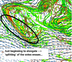
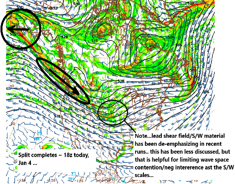
My own take aways from the overnight ... late start this morning - 1 .. the 00z GEFs along with the operational version, obviously made huge leap toward the previous Euro. While the Euro operational solution ( typical frustration) slacked SE while shedding some total wave space potency. I believe this is the early phases of consensus work. It doesn't mean the final solution exists between the 00z respective positions/attributes, per se. It may end up turning out that way. But the 06z GEFs is nearly ideal in terms of climate signal, with the mean of the cluster both deeper more nucleated, but also routing quintessentially for targeting NYC W-NE 'burbs, CT, NW RI, interior MA, S NH and D.E.M. 2 .. the governing S/W mechanics at 06z this morning, are still embedded, but just beginning to establish identity here: ...That 'splitting' has to get underway ... and actually BE representative in the initialization/population of the model grids. I have long been trying to emphasize that there is a kind of 'temporal boundary,' the other side of which exist a more focused truth. Prior to that, the solutions were teetering as to how much mechanics get pulled out and ejected down stream as the S/W we've been tracking.... vs, how much is conserved/ retrogrades with the aspects that goes west under the EPO domain space: ... This has been a unusual 'genesis of threat assessment" scenario. More typically, these S/W origins take place from other events ...way upstream over the breadth of the Pacific...even traceable back to Japan/ EAMT field ejection. Sometimes coming over Kamchatka and NE Siberia ..etc; thus, the way they've behaved/trended in the flow lends to predictive advantages. In this situation, the S/W did not exist, until that split evolution, a process that was always scheduled to take place today. It's why some of us have been hitting Wednesday as the real consensus maker solution spread ( most likely ...). But I feel that these runs today are going to begin seeing the result/ingesting some of the post visualization actually in the materialized sounding grid... I mean, one advantage of this is that almost immediately upon the sever and eject, the S/W is entered the physical/balloon soundings ... so, it will be interesting to see if/how/what comes of that. I still believe this is a candidate for potential short term corrections - example Boxing Day storm, 2010 - not as an analog, but to exemplify concept... I do think it is interesting, however, the 00z GFS/NAM ...American cluster et al, seemed to beat that out, and prior to said bifurcation of that SPV as annotated above. Meanwhile, the Euro broke continuity with it's weaker brush by solution... 3 ..Once we get on the post side of the above evolution, for those into NAM solutions ... be leery of NW biases. The NAM does this from time to time with coastal/near coastal cyclogenesis, routing/deepening lows too far NW. I don't think the 06z solution makes as much sense, as the mid trop forcing is S of the its 06z low. The right exit region of the mid level torpedo wind max is C-S NJ to C-Cod. We'll have to monitor that - the lead shallow CAA will probably lay down a sfc -800mb thermal packing, and between 72 to particularly 84 hours out ( duh! ) the NAM is less likely resolving that particularity - the detonation of quasi-Miller B will probably take place where UVM establishes over/near that lvl frontal slope, because that is where inflow jets turn skyward. Once that happens, the low won't 'jump' NW to NYC... 4 .. I'm not certain the Euro can't fall victim to the uncertainty over how much gets ejected out of a SPV disintegration that hasn't erstwhile even taken place. I am not really sold on the 00z modulation, no more so than I was buying the previous euphoric solutions. Conclusion, I think there is still a better consensus out there ... prooobably materializing during today, but particularly tonight's run may be more critical. Less changing/modulations, run-to-run, will likely begin at that time/ become more trustworthy.
-
That’s not entirely true tho; the 84 hour position on those models vary by almost 300 nautical miles with the Nam further back Southwest. Plus the NAMs total curvature field is broader with the same velocity imbedded as GFS was, when it was in that NAM position. The NAM is propagating more mechanical power. Additional to those other params the NAM’s ability to exceed the deepening rate of that GFS solution is that it also has more time to do it.
-
Perfect climate spot on that particular frame … really
-
Mmm. GFS and NAM models employ different physical parameterization for things like cloud physics … convective processes; this is why the Nam blew. all the other models away on that 2005 December 10 event. … plus with a Nam running a negatively tilting Vmax with 120 mph wind core up over the gulf stream that models going to absolutely MESO-beta scale bomb that at historic RI rates - if that were a metric kept track of.
-
Yeeeah … that GFS looks like a transition solution to me.
-
Meh … first we capitulate, future cycles begin to slow down - maybe not a lot but at least a little. Looking at the NAM …. I’m noticing better ridge response over western North America after the S/W ejection east of the Rockies. That’s always been a crucial sensitivity in this whole thing …driving the translation speed of the trough exit off the east coast is anchored in that ridge amplitude


