Typhoon Tip
-
Posts
44,565 -
Joined
-
Last visited
Content Type
Profiles
Blogs
Forums
American Weather
Media Demo
Store
Gallery
Everything posted by Typhoon Tip
-
Welp …just saw the NAM Y’all undersold that. The extrapolation off that end frame would approach the upper physical bound.
-
Water condensing as supercooled particles … perhaps turbulence slowing phase change, then suspension in UVM core slows particle motion … Medusas solid, then rimes additional supercooled layers that quickly lock- viola. Stones. Must have been a sick theta-e conveyor flowing into a very upright elevated frontal slope with evac fan jet - I bet - over NH
-
What’s the ridge doing behind the short wave -
-
I’ve been dancing with the Boxing Day storm in 2010. Disappeared for two days and came all the way back in like two cycles to wallop everyone excep me heh. No but it too came off the PAC rather blindly in fast flow leaving offices little time to go all the way to blizzard warnings. Actually check that on bl but it was a rush job.
-
Stick to Thursday night ... that way, he'll be all snuggles and tuck into bed by 8:51 pm and misses the whole thing by the time he wakes up
-
Oh ... I see. yeah - good questions. The operational version is a "souped up" ensemble member ...It has incorporated the best theoretical application of Meteorological physical equations -it's called the 'operational version'. Most reliance is there. The ensemble means have less integrated total tech manifolds, and/or employ more 'experimental' physical equations. They are thus considered, 'perturbed' version members. Individually, they are less likely to best the operational model ...particularly in shorter duration lead ( < 72 hours)... where as, the extended complete mean ( all members/ n-terms), offers stability - a kind of normalization that the operational falls victim due to chaos feed-backs cumulatively effecting accuracy way out in time. That's sometimes why you might hear[ responsible minded ] contributors ( lol ) refer to relying upon the ensemble mean in the extended, which by convention is anything out side of 5 days ...Relative to the pattern at hand, sometimes that is shorter or longer by a day in either direction. I've seen patterns where operational versions nail things down pretty tight on D6 .. but I've also seen operational version have trouble as close as D3. The respective ensemble means tend to perform better in lesser confidence circumstances. The last 5 years -worth of winters (imho ...) have not been particularly good operational version years ... probably owing to the compressed, fast flows. Models don't tend to do as well in long X-coordinate, short Y coordinate flow types, which seems to be dominating the winter hemispheres as of late.
-
No one should be "trusting" anything. The models are varying like they should, and usually do...at this range. Now sure what else needs explaining? Maybe we should start threads that are science concept, then, have a side-car thread linked to it that is an emotional catch-basin/support group. LOL. J/k but yeah
-
Well, the one Greg and I were just mentioning was earlier in the month, though.
-
Probably ? Lol yeah no - 1987. It was a flat wave and NWS put up a winter storm watch at 4pm for that same overnight... I awoke at 3am to the sound of thunder. The sky glowing butterscotch ...another flash. Wind and snow occasional lightning... It only last 4 or 5 hours, but longer SE.... We got 9" out in Acton, but I recall some lollypops to 15 around NE RI and the SW burbs of Boston. I remember that previous afternoon, ... cleveland was reporting thunder snow, and TWC mets were all giddy. It was a great! I mean...come home from school on a boring brown Novemeber typical Tuesday... I wanna say 11th or so...maybe 13th ... Turn on TWC to that... and just then, the TV beeps. Not sure if this still happens on regular network television but back in that era, tickers scrolled for weather alerts. While I was watching the coverage of N Ohio, the beeps fired off and, "...THE NATIONAL WEATHER SERVICE IN TAUNTON MASSACHUSETTS HAS ISSUED A WINTER STORM WATCH FOR WORCESTER, MIDDLESEX, SUFFOLK .... 4 TO 6 INCHES OF SNOW.." It was a flat open wave with a 45 vmax like a torpedo. It sniffed the Jersey shore and the PP falls were immediate and insane, as was the leaf explosion on satellite/radar expansion.
-
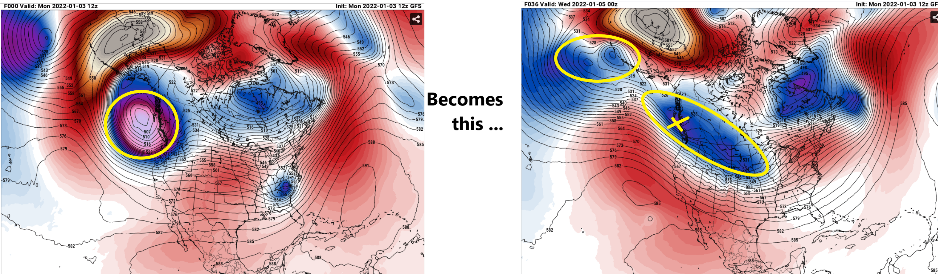
Yup ... I've been mentioning this too on multiple occasions, how sensitive this thing is to that. The PNA mode change - is it exerting a ridge? Or is it more 'relaxation' in/of the -PNA dominance? We seem to be on the fence as to which. The S/W in and of its self is very powerful. Some of these runs have 150 to 170 mph 300 mb wind maxes. Buck-20 at 500 mb. Here's the the thing ... folks should dig up November 86 for a flat wave NJ model bomb that laid 15" over SE zones. God it's like wow -
-
Plus ... regardless of which ens mean I've seen, the spread 'smear' has always been highlighting over the western envelope, which often precedes correction vectors/future guidance. Best example of that was the April '97 season ending blueberry beauty with whipcream on top. D6 lead had the low out near Nova Scotia, but the ( primitive by today's standards - ) MRF ens mean showed that smear back toward the Cape. Gee - wonder if it corrected west, huh. Personally? I feel Scott's concern for tuck is still very much on the table. But, I also feel that a bomb just too far SE could be too. I don't think placement and magnitude are going to really coalesce until after the SPV split up there, and the models sample what really is delivered. The western ridge is still wild-card - subtle variances therein have impacts on the former.
-
Not to indict anyone but heh ... I almost get the feeling there's some that almost want it to ? Guess folks got their agenda - Just wanna remind ( not you per se but I feel like this message isn't getting across ) ... This ordeal was packaged originally as unclear on scale of magnitude. And it was also noted - at least by me and probably a few others ... - that it would probably be Wednesday-ish before this coalesced around the 'gonna happen x-y-z way' vibe, at which point divvy up peoples allotted proportions... Lol anyway... we'll see.
-
It really could not be more definitive and glaring as a mid range test. Euro vs GFS .... the old nemesis. It's funny how seldom these models just like ever agree. I mean, they use the same physics, right ? Doesn't the force of gravity still point down in both AI engines?? Again, I think this is a unique situation... ( I don't think this is registering as I'm not getting any replies? ) It's okay...I'll let it lie at this this point. But even in the over amped versions, I'd be cautious until we get on the other side of that vortex split. This entire increased threat assessment as a thread, began as a very coherent mode change in the total hemispheric circulation footprint. The numerical version is remarkably concertedly in agreement, and both the graphic version of that in the EPS/GEFs/GEPs ... indicate losing negatie anomalies in the S/W ...replacing with positive by weeks end. These are not trivial alterations to the larger circulation manifold, and this is typically when system tend to occur. At a more specific scope. The change from negative to positive PNA, lends to more amplitude and increasing curve flow surfaces. Thus, the emergence of this systems becomes interesting...
-
Short summary on everything I've written ... ... this is a real candidate for short lead time correction. ...Get this to 72 hours lead and it may rather abruptly wait to coalesce in guidance then. Again... after 30 hours from now, the post SPV split will be sampling in real-time. Said split as of 12z initialization has not even begun. We really need to get on the other side of this:

-
In the eventuality that is storm comes to actually verify ... more so than less, I really don't think this ICON model is going to even see it until the model runs beginning ~ 30 hours from now. Prior to that, it seems to have very little assessment as to how the SPV over the NE Pacific will be forced by the PNA mode change - I suspect that has to do with the ICON technically being a meso model ( on 'roids as it were ) and not seeing the domain over the Pacific that is ultimately driving/responsible for said PNA evolution - it's a question I'm wondering.... In other words, outside of its spatial domain. I wish I could see the hemispheric scope of the ICON ...but, being that it is the ICON and I have not seen it perform very well, anyway, over the longer term for just about anything I've seen that is mid range <-- to short range relay, I'm not really inclined to bother. I have read a little about it... According the German org that hosts it, it is a Icosahedral Nonhydrostatic model - basically, ... take the Earth, and cut it up into a icosahedron ..well... one can find all here: https://www.dwd.de/EN/research/weatherforecasting/num_modelling/01_num_weather_prediction_modells/icon_description.html Anyway, I'm just wonder how seamless these jigsaws are, considering that the PNA covers a bigger area than 1/20th of the spherical surface area of the planet. Just speculation here , but if the PNA mode change is not integrating properly across the conjoining polyhedron regions, then it may not be driving the SPV split event right --> shitty returns over eastern N/A mid latitudes.... Or, it's on to something... I don't know if the simpler explanation is really bearing truth in this particular instance, however.
-
There's some era relativity there ... You know, ... given the state of the art of modeling infrastructure/ .. 'AI' and a circulation less saturated with gradient and velocity, D4 would incrementally more confidence than any D5 ..That was always the critical performance 'trust' threshold of the Euro. I do want to get on the other side of 30 hours. As I wrote - probably too long for many read... lol - last hour, there are is contention as to what and how much of it gets ejected out of the NE Pac SPV breakdown. The GFS is either going to win probably the greatest coup attempt in the history of modeling ... or, lose in that debate.
-
Thanks for posting this ...as I'm late catching up this morning - I noticed the rather impressive leap of the GEFs mean ... back toward more impact implications/ EPS look, compared to the previous two cycles. The EPS has been more consistent - as others assuredly either know, or should be keeping track. The GEFs being less so, but recently leaning toward acquiescence is probably a red flag against the operational for this particular system. NO, I don't think this is a crisis for the model the rest of the winter, either -
-
Seasonally ... ? - perhaps. ( Sorry ... wasn't a part of this conversation's immediate history but just an ob on model performance) The GFS has been reasonably consistent. The GGEM has been reasonably consistent. The Euro has been reasonably consistent. The problem is... the GFS does not agree with the GGEM, nor the Euro. The verdict is still out regarding this particular storm, which I feel - full disclosure - like the Euro and GGEM are likelier to succeed, given to some abstractions/ personal observations regarding GFS biases since these recent new version releases. That's by know means a declarative - ... This is a unique situation. As I outlined yesterday there are two points of handling contention: The first being ... there is a majority/ multi-model cluster consensus for the SPV, situated initially over the NE Pac/GOA region, to getsdisrupted - beginning at ~ hour 24 from the 06z initialization. After which, that's when things get complicated. En masse, the SPV gets 'split' .. All models/blends there in, essentially portray some percentage of its vestigial mechanical power as retrograding W under/along the EPO domain ( I annotated this in the charts a few pages back/yesterday if interested... ), while the rest of it gets bumped down stream over N/A mid latitudes - consequentially giving rise to whatever does ultimately manifest along the E/NE coasts. Correctly handling the ballast of that vorticity shearing/ conservation is like trying to predict which way an egg will roll off a ruler's edge, when starting from a position that's more or less precisely balanced. The second aspect ... regardless of 'how much' gets ejected downstream post the split, as it is nearing 100W ( about 2 days from 06z's initialization), the rapidly rising PNA offers some known model error prone as to the fuller( lesser...) extent of the aft region of ridge response. That is part of the total wave length of the storm - for those less privy. If immediately on the tail of the S/W ( say ...nearing Iowa), the ridge bulges more, the S/W will dig more. Now ... I am not entirely sure about the following notion... but from what I have been observing it "looks" as though the GFS is taking more of the SPV, post split, westward with the retrograde motion... Contrasting, the Euro and GGEM take crucially more so southeast. By the way, if one bothers to look at the 12z yesterday morning GGEM and Euro evolution, and compare them to the 00z, you can see how handling of that ridge in aft region of the S/W ejection is excruciatingly sensitive. Ever so subtle in the Euro, perhaps a little more coherent in the GGEM, those heights are higher, and they've slowed the progress of the total cyclone space, while adding intensity - just from slightly higher ridge heights across those cycles. I can't stress enough...this is a very powerful wave in these higher resolution models. Really even the GFS .. But is' flatter wester ridge appeal, ...it's sort of maybe "manufacturing" it's on destructive interference, whilst the other models are trying to reduce that offset factor. The Euro is < D5 ... mm. All the models are at 48 to 60 hours lead, for whether there will be a real S/W over the CONUS at all, so that pretty much wipes out any remaining doubt in my mind as to "weather" we'll see a storm evolving here. Switching the title of the thread to 'tracking' as opposed to 'potential'. It's also helping that the -PNA --> +PNA, emerges a negative teleconnector centered on the OV, both numerically in the GEFs derivatives, but also spatially in the pretty art of the EPS/GEPS/GEFS graphics, that really also nods to the logic that the GFS is again fighting the consensus as an outlier - perhaps even the very physics of the mode change. There is an interesting irony about this ... The Euro and GGEM have generationally been more guilty of leaving behind mechanics... while the GFS has a kind of genetic lineage to be more progressively biased. These models types have improved over subsequent versions ... but from time to time one can still get a vague sense that their tendencies still lurk. This is a situation where respective camps appear to modus operandi.
-
Yeah that’s essentially projecting a severe winter storm … this run is a slightly slower/deeper version of the 12z. watch the ridge in the west this run and compare. It’s slight taller and immediately the system slows down trading E for S component in system translation speed. It’s subtle but that’s 12+” vs 6-9” keeping in mind it’s the GGEM
-
Re Jan 7: Mentioned this in the banter... Sensitivity - to me - resides two fold: one is in the correct handling of the western N/A ridge aspect as the PNA enters mode change during this week. That can be a problem as to the true arc extent of the ridge envelopment; particularly if/when ejecting a very potent mid/u/a/ S/W through the field - if handled improperly and is bigger ... the burgeoning does so immediately aft of the S/W which is an accelerating constructive feed-back. Moreover feel the antecedent table is setting with height reduction/resistance over the Gulf/FL/ and adjacent Atlantic. These S-SE regions down toward lower 580s dam, with less than 50 kts balance geo-str wind, signals less destructive interference. Watch out for rapid rising PNA with nested mechanics! We await the the ridge amplitude and the following... 2ndly, the bifurcation in the 30 to 40 hour range wrt to the SPV over the NE Pac. The PNA changing mode disrupts that...and recent GFS operational takes the ballast on a retrograde motion, whilst the Euro cluster takes more SE as our S/W in question. Depending on which is crucial. I suspect the Euro at this range, however, given to it's superior resolution and correction/tech in play. Basically... watch this for more than merely SNE and points NE for impact. Plenty of time...
-
You folks of this forum's interest region are on the fence nearing Jan 7, for a short duration snow/ potential ending as wind combo - Sensitivity - to me - resides two fold: one the correct handling of the western N/A ridge aspect as the PNA enters mode change during the week - that's usually a problem as to arc extent with that envelopment, but is problematic here... because we eject a very potent mid/u/a/ wind max through the field and said amplitude - if handled improperly and is bigger ... - does so immediately aft of the S/W. That creates more depth in the TV, and with height resistance over the Gulf/FL/ and adjacent Atlantic coming toward the lower 580s with less than 50 kt balance geo-str wind, that signals less destructive interference, such that has been the case the vast majority of times this early winter. 2ndly, the bifurcation in the 30 to 40 hour range wrt to the SPV over the NE Pac. The PNA changing mode disrupts that...and recent GFS operational takes the ballast on a retrograde motion, whilst the Euro cluster takes more SE as our S/W in question. Depending on which is crucial. I suspect the Euro at this range, however, given to it's superior resolution and correction/tech in play. Basically... watch this for more than merely SNE and points NE for impact.
-
Ha hahaha... no schnikies - I mean it'd take two shifts to analyze the whole set - you think you'll population the dbs and make ur AFDs in time.
-
heh ... my interpretation of that is different I guess. That looks like an actual temperature/thickness distribution that is marginal, as those correlate to scalars of the isohypses; meanwhile, the flow configuration is still in the positive mode of the PNAP. It's 'warmer than normal' heights in general but 552 heights can host 536 thickness, and we have the flow nadir anchored near 80W. Having said that, ...yeah, it is annoying. Lol. I mean there was less contention in the previous version(s).
-
Heh... I always thought that description best fit the EPS... which it may - just sayn' I've often found that if the operational run "looks" more(less) favorable, the EPS mean does too, in the relative scope.