Typhoon Tip
-
Posts
44,565 -
Joined
-
Last visited
Content Type
Profiles
Blogs
Forums
American Weather
Media Demo
Store
Gallery
Everything posted by Typhoon Tip
-
My hypothesis is pretty easy to come by but fwiw, they do so now to get their greed ironed out and divvied up before having to compromise actually delivering the product that allows them to bathe is avarice in the first place ... But who knows.. You know? - not all billionaires are actually bright people - you have to read that scientific paper released where the researchers/authors used AI and math of 'doucheness' to prove that income and wealth inequality is way more realized by just dumb f'n luck than those with it know or acknowledge - One could almost imagine them still squabbling and counting their cash when the fans have already walked away. Baseball's in trouble. It has been for awhile. Between Millennials really not having the attention span or the heritage ( in either ..) to create a culture of interest, and the present generations aging and dying off... - it's an interesting outlook for a game that take inhumane hours to play and with eternity between in-game events - with it's present model and product profile it's got no chance with the way the world is changing. They have to do something to make that interesting... Like, how 'bout make it a contact sport - heh... yeah. Go around 2nd base and close line the 2nd baseman trying to field the ball. Just put helmets on 'em ... obviously not serious.. but MLB does have a matriculation problem
-
LOL right, cuz 2.5 weeks later pitchers and catchers report -
-
That 'Miami rule' is being violated like a casting call hottie ... I can see why the Euro keeps that thing not only positively tilted, but moving at ludicrous speed. I wonder if it is possible to actually have a storm move faster than the fall velocity of snow, such that it doesn't.. haha. Kidding, but I think that D11 and 12 extrapolation off both the 00z and 12z Euro would be much better candidate for less negative interference. Love to see those charts if just for the entertainment and addiction's sake LOL. No, but you can tell the flow is poised to pop a ridge aft of that S/W ejection in the Plains on D10; meanwhile, heights over Miami are < 582, and the wind is < 50 kts prior to arrival. Those two are scaffolding for constructive interference ... and the wave in both those cycles proooobaby looks tasty around NJ, extrapolated. In the meantime, I still think the weekend is more significant than this smattering of nuisance snow and mix intervals during the shrapnel this week. But I like the idea of that demagnifying toward more of a flat wave and possible more ice problems ...
-
December 2021 Obs/Disco...Dreaming of a White-Weenie Xmas
Typhoon Tip replied to 40/70 Benchmark's topic in New England
Heh yeah, and though we realize the snark in your post here, perhaps motivated out of smoldering frustration ( lol ), the upshot (for me) is that those excessively deep category 4 hurricane depths are - duh - less likely to verify anyway. Just sayn'. But, I've long been annoyed that this engagement, which some validate by calling it a hobby ... is really more about a model-cinema create pre-dystopian euphoria/addiction. Folks are probably more at a sense of loss in the days preceding any event, if the that period of time sans that "charge" they get out of model pornographics. The storm? yeah, they're kinda cool. LOL How's that for snark? No, but mid latitude lows tend not to sub 950 at our latitude, though can occur ...very rarely. Rareness, by convention, should require huge degrees of incredulity and skepticism, particularly for beyond D5's. But ... alas! There will be those that don't seem to ascribe or operate within convention - huh. I saw some reasons overnight that are more rational, in all seriousness. Yesterday I wrote that the telecon spreads ( provided by GEF -based) were not altogether very supportive of a big continental mauler low ... like that which the the GFS has been insisting now for ( as far as I can tell...) for some 4 consecutive days of model cycles. Sometimes more primary, sometimes more commitment to coastal as a bona fide Miller B .. but carrying the system nonetheless. Particularly in the PNA. Still, at the time, there was a tentative trend in the EPS to be more amplified with the same trough ejection through the west - a trend that continued 00z last night. And that was also when the GGEM runs began nodding to the notion for bombs. I surmised it is possible that this is one of those rarer times when the higher resolution, more 'souped up' model versions lead the telecon, and that the latter may start opening up to the notion in future cycles. That happened Last night, ...about 1/3 to 1/2 the GEF members instantiate a mode change in the PNA beginning in 6 or so days, one that carries on through week two. The signal is very new... but, when one surmises a notion, the the notion gets supported ... it makes it hard for the notion creator to dump said notion. Lol... we'll see how it goes. This appears ( to me ..) to be the next significant event, but probably it is in the magnified/over-amped phase that all models regardless seem to do with features in the D6-9 range. -
December 2021 Obs/Disco...Dreaming of a White-Weenie Xmas
Typhoon Tip replied to 40/70 Benchmark's topic in New England
That 00z GFS would be a record setter. heh -
December 2021 Obs/Disco...Dreaming of a White-Weenie Xmas
Typhoon Tip replied to 40/70 Benchmark's topic in New England
I was scanning the individual GEF members and about 2/3rds of them were signaling a highish latitude Miller B spanning next Weekend+1 day. Large system...originating as a Colorado Low/ continental mauler - something I personally have not seen in quite some time. This type of low can run moderate to heavy snow totals over a wide expanse ... polarward of a primary track from circa Denver to circa Detroit ... Buffalo region, prior to coastal commitment. The other 1/3 have either too much primary... or... to weak over all to be meaningful. Over all this is a trend over the previous two consecutive cycles in the mean ( and indiv. member count ), gaining coherence for that signal. I'm not seeing where the telecon spread from the GEFs signals the Archembault - typically H.A. events are pretty clearly signaled in the former so it is interesting. This feature has been on the operational GFS for three consecutive days worth of cycels...varying between more primary and ice storm cinema, to more commitment to coastal and quite the wallop from PHL to Maine as K.U. The GGEM jumped radically on-board this 12z, but it's solution make-up looks unnatural with a 980 mb low over BUF escaping soon into the Maritime, and then 30 hours later, a sub 950 mb low abeam PWM... That's like never happened, and for a reason. I haven't seen individual EPS members, ...but the mean trended significantly deeper in the total 500 mb between 12z on the 25th and 12z this morning. The operational version is emerging, albeit slowly, ... an active baroclinic field with [ probably ] a multi -wave impact. Usually the ANA-esque open waves at this range is more like a reservation so.. So, with this fledgling consensus for an active New Year's weekend across the country, with [ probably of more importance at this range ] such a massive system with large mass field involvement... it's probably not a mere red herring. I'm just a little leery about the 'magnification' thing the models do ...where they see these things on the temporal horizon like we see the moon’s first rise as a giant pancake. It is also possible - and sometimes does occur - where the higher res "souped up" model types/operational version will agree on a signal, and backward of convention...the telecon opens up to the idea. I just find it really interesting that the type of system in the GEFs members is a typical of an index modality event, yet the PNA isn't impressive there, which is based on the g-damn GEFs... -
December 2021 Obs/Disco...Dreaming of a White-Weenie Xmas
Typhoon Tip replied to 40/70 Benchmark's topic in New England
I love the artistry of forecast models sometimes... Best gallery around - -
May get periodic freezing drizzle as it gets dark and the top of the low lvl saturated cold layer attempts to shed degree decimals
-
Scan elevation ? ... maybe another higher warm layer. I mean the 'tuck' doesn't mean it's cooling above necessarily, right ?
-
I've been watching that all morning .. yup- We're likely to tuck that all the way and see it teriminate down the eastern flank of the Worcester Hills ...not sure if it spills over. Will and I were onto the aspect that the warm layer in this isn't ideal. The droplet temps are ...a little toasty heh. But that is needing more cold air to help phase change efficiency that normal - relative to temperature. I think that is happening visibly here just N of Rt 2 in N. Middlesex Co in Mass. Ayer - I have icicles and poor accretion efficiency, even though it 30.5 F ... The rain rate is not very heavy. Steady and light ... Typically we could see that be very efficient at that temp but we're not. I'm wondering if that's related the fact that it's probably 40F atop mt Monadnock. the 12z NAM has gone cold over Logan out of nowhere... hmm. It's only +2 C at 900 now by late afternoon.. .yesterday's 18z was +5! That's a pretty substantial short lead term shirking on plans.. If that is true, the tuck pulse above does come on down... we may have seen the warmest this gets. That might not be good considering how loaded the upstream rad is...eesh. Man, icing events have no equal when it comes to excruciatingly tedious micro now casting LOL
-
December 2021 Obs/Disco...Dreaming of a White-Weenie Xmas
Typhoon Tip replied to 40/70 Benchmark's topic in New England
Hope you had a good morning opening presents in with icing going on... nice. As far as your concern above, absolutely ... well, most likely. But yeah of course it is. No argument at all. Like I stated - and still believe will be the case ... - this year will have shared real-estate, sometimes more ... sometimes less reflecting the La Nina, relative to climate expectations - " ..I thought this year would pass the hemisphere in and out of La Nina.." ( just to be clear - ) .. Certainly so far since say, mid November, this journey's been consistent with La Nina destructive interference ... some telecon correlations - MJO being one of them, not correlating well, or like behaving weird. Frankly, as far as the HC damping stuff - that needs clarity too: The 'damping' part as an HC effect, is a hypothesis that as far as I am aware, only on my part. But I'm sure with the vast number of heads in the business, I'm not the only one scratching head.. It's not about that. Just that it's not sent through rigor. That said, HC expansion in and of its self, that much is not hypothesis. It's empirical. The HC part of the total Walker circulation model has/begun to expand outside of the ENSO over recent decades ... That is by virtue of geometry ( really ...) disconnecting the equatorial ENSO's direct latent heat diffusion model, ever more; that separation is the damping. It's not so much a physical damping like holding it down; more so the lowering the ability of ENSO's direct modulation because of the growing disconnect. The advent of a powerful +EAMT signal in the late mid range/ .. especially extended blends, that would tend to modulate the Pacific circulation toward a newer paradigm than recent weeks. Whatever emerges: does it constructively vs destructively interfere with La Nina. Early indicators appear to suggest latter, as more and more individual GEF/EPS members ( using that metric indirectly ...) are beginning to emerge for Phase 8. Plus, the AO is is correcting down. It'll be interesting to see these indexes over the coming dayts, because if they continue to emerge this way, that would be competing against the La Nina footprint, and could herald one of those times when we hemisphere less reflects the cool ENSO mode. -
December 2021 Obs/Disco...Dreaming of a White-Weenie Xmas
Typhoon Tip replied to 40/70 Benchmark's topic in New England
Wow … that is one deliciously nasty storm in the GFS D8/9 …10 its like .7” accretion over to 45mph CCB snows … There’d have to be two fade in headlines -
CMC has a much more impressive ice set up 2.5 days later …
-
Yeah no shit. CMC stays ZR the whole way. I’m noticing ever so subtle but more robust positive surface pressure pattern damming down eastern New England on that guidance comparatively. I’m wondering if there might be a little bit more ageo just critical
-
It all really draws the notion that the worst ice storms must be some sweet ratio between heat released thru phase change, vs offsetting heat sink feeding into the accretion layer. too much one way … more PLs … go the other and 32.1
-
December 2021 Obs/Disco...Dreaming of a White-Weenie Xmas
Typhoon Tip replied to 40/70 Benchmark's topic in New England
Yeah no … I guess it just effects people in different ways. Bottom line I don’t miss it and generally feeling and most importantly being better, are the barometer. -
December 2021 Obs/Disco...Dreaming of a White-Weenie Xmas
Typhoon Tip replied to 40/70 Benchmark's topic in New England
Heh. Thanks but fuller disclosure … I didn’t have liver issues. I was getting physicals thru that era and blood work never reflected that. -
December 2021 Obs/Disco...Dreaming of a White-Weenie Xmas
Typhoon Tip replied to 40/70 Benchmark's topic in New England
I wonder if there's ever been a teleconnection calculated using the circulation mode over Japan ...around the world? That'd be cool, heh. There's are little known rule of thumbs out there. Like, tornadoes in Michigan tend to offend New England 24 hrs later. Or troughs over eastern N/A tend to correlate with troughs of western Europe. I can imagine these types of concurrency are more related to geometry/R-wave distribution. And if so, wonder how far that extends. There's obviously an Indian Ocean telecon with the -NAO... so - good post though. You should chat with Weatherwiz - another Met that bops around the forum. He was all over the Asian feed and needing that to change the relay into the Pacific. I think he even said words to the affect ( or is 'e'ffect) of, ' ...won't see a real change until that happens'. Maybe this is it? I happened to agree with him. Part of the reason for the MJO stall in 7 is that the wave is having mechanical trouble propagating out of the Marine district, ...I suspect the reason for that stall may very well be because given the west Pacific torque model as it is dispersing off eastern Asia, it may be suppressing/ destructive wave interference. CPC's been blaming it on the La Nina footprint of the hemisphere; they may be entirely right. But I have my doubts whether that part of it is the 'cause' vs more coincidence. The last several ENSO events have performed poorly in coupling to the hemisphere base-line circulation, so suddenly this one is? Okay. Personally, ...I discussed that apparent breakdown over the last years, and that I thought this year would pass the hemisphere in and out of La Nina; ha, if I'm going to be right about that, now might be a good time for your +EAMT to get real. Maybe the MJO then starts propagating into 8 and beyond, if/when that happens.. .There are more individual members on the RMM that appear to curl.. .and I also noticed the operational GFS and Euro version began yesterday, rolling SPV saws through lower Canada - yeah...something could be brewing along the lines of pattern/wave# change. -
December 2021 Obs/Disco...Dreaming of a White-Weenie Xmas
Typhoon Tip replied to 40/70 Benchmark's topic in New England
Funny thing ..it doesn't seem like an ice "threat" to me... Not sure I see a strong enough ageo wind to really offset the conduction temperature of the rain. It's falling through +5 C at 900 mb level...That's pretty fantastically mild not far off the deck. Plus, any marginal icing that gets going utilizing low level initial 30 F, if there's only light drain the latent heat of phase change will have it 32. I wouldn't suggest no ice at all.. Just that it would be like that thing the other day. With some glaze mottling on the car windows, then it's 32.3. Maybe that's all we're talking about. I mean, it'd be weird variant on the "white Xmas" theme to have icicles dangling from power lines and some modest sag on trees and shrubs - love to see it - if we can manage that without losing power, heh. The novelty of ice runs out on me in about 4.8 seconds aft of the lights and white noise of the household going abruptly crypt quite. Obviously this wouldn't likely add up to that, anyway .. just sayin'. Not a huge fan of ice "storms" ... Icing? - sure. Keep the power on though. -
December 2021 Obs/Disco...Dreaming of a White-Weenie Xmas
Typhoon Tip replied to 40/70 Benchmark's topic in New England
I found this beer .. small brewery out of Kansas City - well ...may be bigger now, or no longer exist, not sure. They were called "Sixth Glass." They made this amazing 10.4% potent IPA that had an almost creamy sort of velvety finish to it. It was amazing. It went well with just about any meal, or just nursing during the game - multi utility, and yes... given to the 10.4%, you really only need a couple of them. If downed on an empty stomach, perhaps only one. Amazing beer. Now ... personally, I haven't drank any alcohol in 7 years - despite the marketing pitch above. Ha. But I had to make the conscience choice for better over worse. I wasn't an alcoholic .. .at least I don't think? But, I did at the time feel I was engaging in life style that was not healthy, too often. The proof of that, I was beginning to manifest physical oddities that I don't care to delve into -LOL. Anyway, since stopping, all vitals are vastly improved and I weigh like 180 .. .Turns out, I'm actually a tall slender bloke - not that barrel chested after all. Probably TMI but ...I guess one doesn't always know when a lifestyle is creeping into a dangerous territory. It can be a very gradual process, where one's body adapts over time; meanwhile, the adaptation is muting the sensation of the erosion going on - then there you are ... hosting an uneasy conversation with a doctor...etc. I mean, I wasn't even getting much in the way of hang-overs like ever... Yet I could put away a bottle of wine and one of those IPA's above every night. Go to work fine the next morning... fine. Gradually got to that state over years. So, I suppose I needed the change at the time - duh. But it went painless for me. No withdrawal bullshit or cravings. Nothing. Stopped one night on a dime and never went back... I really only missed the cigars I used to have along with - that's really a nice combination. Really soothing. Tie one one then spark up a blunt... My god, can't believe I used to engage like that. Now? I work out every day crazy -like. I run 10K, then bike 24 miles the next day, then do an hour on the full press Elliptical, and weight train every other work out. Eat organic, high in fruit and veggies. Lots of water. Sleep regular...basically, no life. But hey, I feel topico! -
December 2021 Obs/Disco...Dreaming of a White-Weenie Xmas
Typhoon Tip replied to 40/70 Benchmark's topic in New England
Lol ...I here ya, but I'm into Meteorology scientifically too - not just the experience... I mean I'm not trying to gas-light by saying that - it's just the reason why I bother. That said (and all empathy conferred), I'm not so sure that it ends up rain either. I mean, let's just make it clear; it's less likely to happen the way the GFS. But, suppose the less odds won, it could correct S to atone the -NAO suppression. I also just pointed out...I don't think the Euro is "partly cloudy" ...? That much wind max tunneling under our latitude is likely to induce some light if not middling frontogenic response on the polar side of the wind max axis. The bending of the PP is a tall-tail sign/convergence for there being lift going on overtop... I think that could verify more cloud with mood in the air. The Euro is 33 at 12z in the interior, then 40 in the aftenroon as is, but if correcting - those are colder. The Euro could be exactly right, as is, .. no modulation necessary.. But it's differentiated it's surface evolution compared to the 00z, so it's not like it's putting on a great show in the parade of solutions here. It can be modified around it's essence. -
December 2021 Obs/Disco...Dreaming of a White-Weenie Xmas
Typhoon Tip replied to 40/70 Benchmark's topic in New England
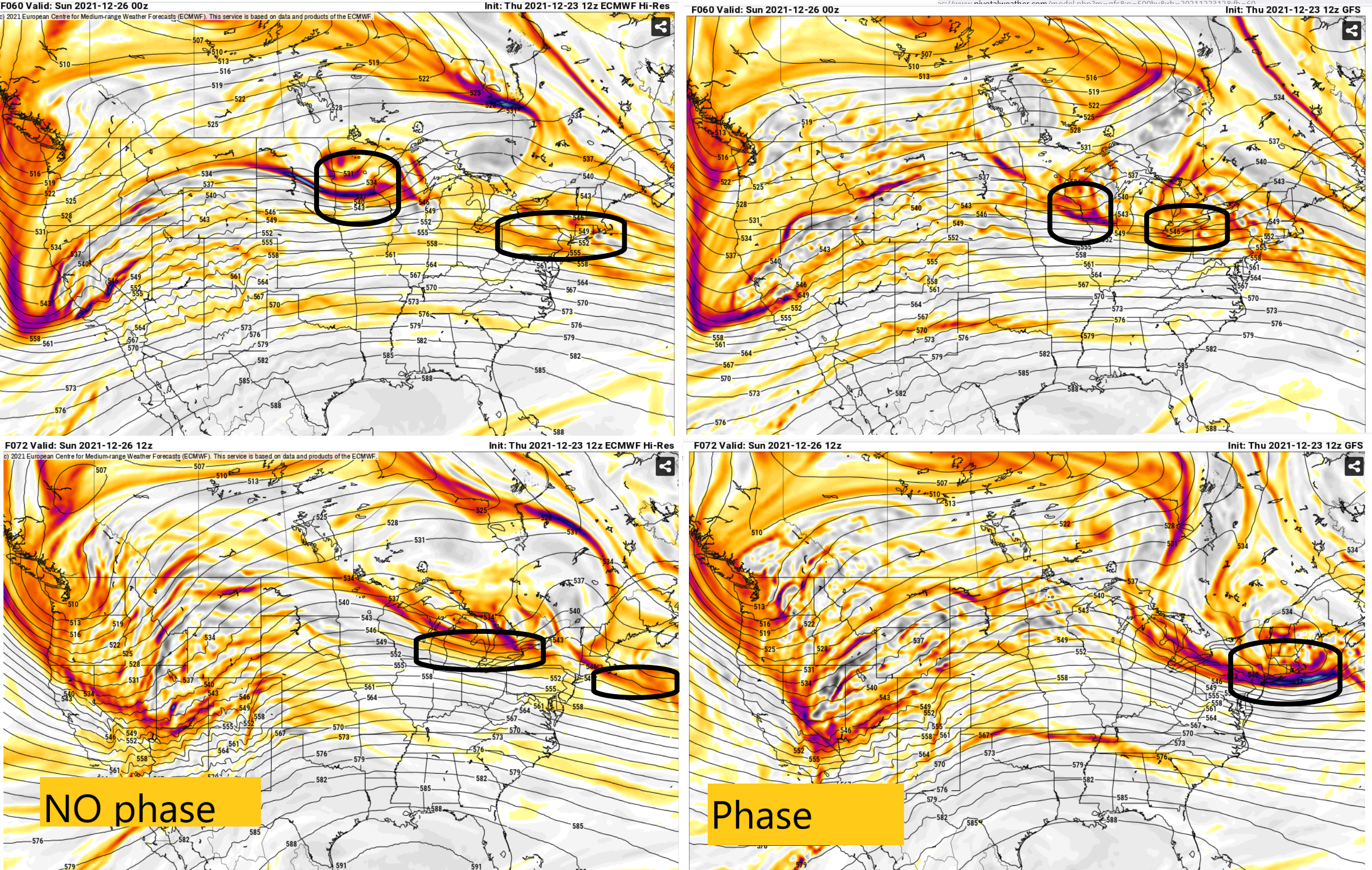
Actually ... doing a model comparison, interval to interval, between GFS and GGEM. The differences really appear to be in the complex stream mechanical handling over the Rockies ~ 48 hours, then notably so over the ~ Chicago longitudes/latitudes. That is where the two begin divergence with surface implications. The GFS has the Xmas S/W/ .. vestige, in the process of shearing out over the eastern Ohio Valley, while it has a flat wave with an impressive wind max over the eastern Plains/Iowa region. The GFS appears to phase this latter S/W into the remnants of the lead; altho remnant as it is, it is enough to positive interfere along a narrow corridor, and we end up with a more impressive/evolved total cyclonic response over and leaving NE. It would likely snow meaningfully for 4 hours of something from RUT-Brian ...maybe down to MHT, NH and PWM. It's not an altogether climate friendly total evolution - it would be anomaly. But I find it if nothing else, interesting that if one hovers their mouse-pointer, over "Prev. Run" ( c/o Tropical Tidbits) and clicks it 10 times beginning at this 12z's 72 hour, the GFS has ended up on that cyclonic look for 10 consecutive cycles. You know ...we've often noted the 101, 'continuity' - can't argue that in this case. It just makes it that much more embarrassing when a model is contiguously a piece of shit - if it comes to that.... The GGEM on the other hand...lets the lead S/W finish deterioration/absorption into the confluence deformation of the -NAO exertion/negative interference. The latter mid west comes in... and does still have enough identity in the total wave-space to at least give cyclonic response ... maybe 1/3 the profile. A lighter event. By virtue of weaker jet fields ( weaker erosion/WAA) it actually allows light mix down to Rt 2... K, adding the Euro to this discussion now too ... It looks even more separated than the GGEM... which really puts it in the diametric camp comparing the GFS. Interesting at this range to be that variant. But one aspect about the Euro - as an aside - the follo-up S/W is actually potent in this run. So much so that as it rounds the semi-permanent TV pig and dives SE, it's bending the surface pressure pattern... Not sure what the IVT/Norlun aspects could materialize, but I wouldn't put that beyond the realm of possibilities, either. There's just a tone of chaos potential with these closely spaced S/W spraying over/through the Rockies over the next 48 hours. I mean, the Euro could be more right in essence, but then necessarily start painting more IVT QPF in future guidance anyway. ------ The short take away here is... the GFS phases nuances more, and that constructively leads to more cyclone response. The GGEM a little less...the Euro even less.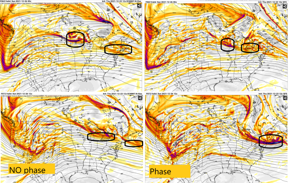
-
December 2021 Obs/Disco...Dreaming of a White-Weenie Xmas
Typhoon Tip replied to 40/70 Benchmark's topic in New England
So it probably won't happen - this 26th ordeal ? Or maybe some muted vestige in some arguable sense of it will, but not like the GFS ... We've been wise not to buy. However, there is the fact that other guidance had something similar enough carried along in the their 00z synoptic evolution, that something is/was there in the physic more so than the GFS merely fabricating - which the latter doesn't really happen... but for brevity. What this comes down to as a deterministic critique is either going to be: - why does/did the GFS do this or -why is it that the GFS was capable of picking up on this where the others were so vacant/ or at best low consistency My guess is we will be looking at this along the first of these two questions. -
December 2021 Obs/Disco...Dreaming of a White-Weenie Xmas
Typhoon Tip replied to 40/70 Benchmark's topic in New England
I don't doubt it ..heh.. But is he Met or climate or ? -
December 2021 Obs/Disco...Dreaming of a White-Weenie Xmas
Typhoon Tip replied to 40/70 Benchmark's topic in New England
Who's that ?