

Typhoon Tip
-
Posts
43,462 -
Joined
-
Last visited
Content Type
Profiles
Blogs
Forums
American Weather
Media Demo
Store
Gallery
Everything posted by Typhoon Tip
-
Okay, well ...if that is the case, that may help offset the latitude vs structure/intensity argument. I'm mid way through Page 11 in catching up LOL
-
Here's the thing ... ( you didn't ask, but it's a straw-man op ) A slow moving cyclone does not have the west side wind subtraction mechanics. When that happens, ... keeping in mind, that is an artifact of the forward motion of the cyclone arithmetically offsetting the wind speed over the western sector - ... slow moving thus means, less subtraction. In that simple aspect, yeah... west or east wouldn't matter in this case - or matter less than the typical climo of a "Long Island Express" Having said that, I have a problem with these UKMET and 06Z GFS solutions for an ambrosia of pretty obvious limitations. One, ...as you and Ray and me and anyone else sentient to the field knows, ...slow moving TC's over cold water doesn't lend to UKMET/GFS glory. In fact, opposite... So why they are doing that maintaining intensity is a mystery considering slow movement. Two, the compact structure they are also illustrating is unlikely at this latitude. It will almost have to be in transition to a hybrid/cooling core phenomenon, at which time it is spreading out over a larger circumvallate. blah blah... this is all geo-physical and climo clad...
-
That would be an interesting study ( page 11 now ...) How does the greater ambit of law enforcement handle both spikes in violent crime and homicide because of that Full Moon jazz, while there is carrying on with a category 1 or 2 blow ? Now that's an interesting convergence of teleconnections there. LOL. I mean wow Or, it will be kind of darkly comical to have all these mayhem enraged moon zombies having no where to act out, BECAUSE the storm is blocking their access to assault targets. It's like having to call the game in the 5th inning because of the weather -
-
Still catching up and excoriating when not making fun of everyone ... LOL j/k ( assholing is fun sometimes, sue me!) But this solution and that UKMET dream-boat storm enthusiast long lost love of life returning to make things right solution... stress plausibility for a lot of reasons. Having said that, ...yeah, not numb to the notion that this is very consistently being handled by some of these guidance. I haven't yet seen the rest of the reaction to the Euro, nor much mention to the 06z versions, - but I still would not trust those off mains and or Euro, even if the Euro 'seemed' to initialize better. I think part of the problem with the Euro isn't just the initialization - it is systemically not agreeing with the other model on the intensity - perhaps - for native physical computational analysis to that model. That's a rabbit hole - Still just a monitoring thing - exciting? Yup, but we are like .... yellow alert just yet.
-
Yeah...this is no analog frankly, not synoptic, not origin, not anything other than the concept of "TC" in general -
-
I'm back at page 10 giggling, then rolling eyes....then scratching forehead over post - nice... But, they probably went in and force the Euro initialization by plugging in numbers. When is that organization going to admit that their product is an interpolation more so than an organic physical process, a suspicion that gets exposed at the boundaries of the domain like tropics and so forth... Heh - sumpin like that.
-
Yeah. This has begun to smack more like a fade season. it didn’t before. But now and lately they’re trying and it’s no longer happening - magic left them.
-
um... yeah - NHC advisory has that?
-
It initialized it too shallow in pressure depth - suspect run because of that. Inertia is important in the equations of all motions. You don't understand that? leave earth-sciences related forums and stick to gardening.
-
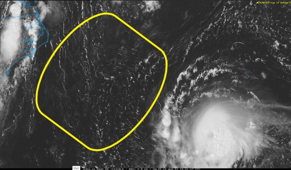
Looking over the total layout from sources... It seems to me this region annotated below is the better region for intensification. The shear should be less over that geographic window of opportunity ... ample warm g-string water .. yadda yadda should Henri make it through that region.
-
I may represent the minority in this jest ...but that would be fine for me in this case. I don't need to witness 120 mph anything unless it's cash to my bank account delivery service -
-
Lol .. .it's like, 'yeah, Euro doesn't need to initialize it' hilarious .. thanks though for providing these
-
NHC operations -related question: do they still employ DIVORAC techniques? I don't hear them referencing that as much - if ever as of late - in their updates wrt to specific entities. More over, I don't see DIVORAC products as easily/readily as years ago now that think about it. Maybe some newer tech has supplanted that method ? I just used to noticed primitive eyes showing up earlier/clearer in DIV.
-
It's bizarre seeing Henri approaching the U.S. from that azimuth
-
I am - the GFS is just such a Global instrument of mass destruction - LOL no, but I think that it is more trustworthy at least in the short term, seeing as it even knows it is there - the Euro doesn't make it abundantly clear that it is resolving Henri at point of initialization, it's not going to be subsequently clear that it is properly interacting with "reality" out in time just the same. As far as the GFS out in time.. mm,don't know about that whole looping shit though. Time to work that/track I guess. But a couple things occur to me. One, west Atlantic ridges are notoriously under handled. Sandy was originally into Maine ... end up near Cape May, much for the same reason, the -NAO/westerly biased block became more mechanical in the steering as a correction - the track shifted west and ultimately down the coast accordingly. Two, Fred appears to have ended up on the westerly envelope track - sometimes in situ synoptics repeat. Is this one of those times? Both these two facets may lean a climo inference toward a west position - hey, at least there's a clad logic to this reasoning. Also, I am seeing a primitive eye on vis this hour. A stronger system interacting with the surrounding medium "might" also alter matters. ..the impetus being, emerging eye may indicate strengthening.
-
I needs ( Euro ) to initialize the system deeper - deal with it.
-
Now that I look closer at the GFS... That's a boring solution for storm enthusiasts frankly. It's lifting the cyclostrophic disk above the BL by the time that cross L.I. ... That 990 low at the time/position near NYC, probably doesn't bring much down to the surface given the rate of weakening and the decoupling from the cold water/land interference imposed leading and during that time. Sorry. Then it comes over a quick responder stream over banks deal... something more like that.
-
agreed
-
Imho .. can't be used until it does.
-
I'd like it to actually 'see' the fugger first -
-
This NAO curve does support some semblance of blocking ... I mean the NAO domain is large enough - it could be more so over the eastern vs western limb where that takes place. But since the modest blocking that rolls over top and settles S of NS seems want to be the primary conductor in sending Henri circuitously as does ( GFS), having this synoptic super-structural indicator is probably fitting -
-
That was the general tropical thread - not sure that should have been closed? lol - whatever.
-
Certainly not impossible, no - 'loops' to me are almost like resolving uncertaing causes the loop more so. Lol... Half kidding. Loops do happen, but blah blah
-
Probably not a whole helluva lot of scientific merit in making the following statement... buuut, I don't like it when models get cutesy with loops and weird stalls when handling a type of phenomenon where predicting those aspects has almost never been achieved - very well at least. Perhaps the state of the art with that sort of thing is better ... but D4? My experience is that it could just as well mean the entire handling can be disrupted in future runs - and that probably in spirit does have merit. But, I mean, I almost wonder if we should considering it a negative in deterministic.
-
So it begins ... muah hahahaha

