

Typhoon Tip
-
Posts
44,567 -
Joined
-
Last visited
Content Type
Profiles
Blogs
Forums
American Weather
Media Demo
Store
Gallery
Everything posted by Typhoon Tip
-
Huh... I think we're being a little harsh - George, sets himself up good and proper for excoriation ( heh ...wow -), but there's worth-while observation still out there re this. But, the fact of the matter is, the general flow scaffold is still there. This can still emerge. I don't personally know how to tell if that emergence will or won't take place... I would presently lean no - but that doesn't mean shit. One run looks better, I can see that happening just as well. Like I outlined earlier, the critical window - for me - will be about 3.5/4 days from now, as the ridge 140 W repositions to 110 W.. That adjustment may send a correction toward more amplitude into the eastern CONUS when that happens - and can emerge in time. Assuming the former does. But that much of it is higher confidence. What happens on the other side of the ridge movement has some upside variability to it. That's the objective perspective from where I'm sitting - seeing as anyone gives a shit what I think. Lol... That is the best I can offer George's ambition to getting us one step closer to ending the world in the 3rd Geological Snowball Earth
-
Mmm... the legitimacy of it may be a bit subjective to the observer here, but VDII is real. It's just not at the moment looking very promising - granted... But D5-7 still has ample time for better reveal.
-
Can't you like ... pm George, and white glove influence him to redraft something more representative of present signals/reality? god - It kind of ruins it if we want to be 'serious' and apply Met objectivity and substance, when it sounds like b-movie horror tropes
-
For muse only - the 12z ICON arrived quite significant+, for HFD-PWM and Phin country
-
I just gave a run-down above - you wanna move it over there? or - It's premature to start a thread in this particular mise en science/leading 'feel' ..but, I think that thread's title being much more conservative might help but -whatever
-
Re Valentine's Day ( VDII ?) Short version: I see room for growth in the runs, ensuing. At just about any time through about D4.5 ... this may emerge with more prominence in the runs. If we get to D5 and that has not happen, pull the plug. Long version/philosophy: The EPS behavior over the far E. Pacific/near of the West Coast of mid latitudes is critical - I'm thinking other's must have cited this. I'm not expecting this to be any kind of unique insight. Starting 00z, both it and the GEFs have a modest positive non-hydrostatic height anomaly stretched W-E of 140W/~45N ... Rather abruptly, the next 24 to 48 hours sees that region flare a rather robust positive anomaly, helping to force an arced flow extending to 55 N and concomitantly, ...forcing the flow over ~ 110W/50N to tip into the NW trajectory. This continues onward through D3... That's when things get complicated/interesting... Between D3 and 5, this above ridge progresses/biases its way to the 120W longitude by 120 hours. D5/6 is when we would tend to see a constructive interference feedback on amplitude ... if one is going to exist or make use of this scaffolding behavior, carving S through the NP into the MV...etc... etc. This is why D4 ~5 are critical windows. If that has not begun to happen prior to that range ( 00z through Fri)... heh. The numerical layout of the GEFs telecon is tepidly supportive .. very modest suggestion here: That may be okay.... The blizzard recently was also led by this sort of flatter presentation of PNA disturbance. Graphical reliance helps bridge the uncertainty as to whether anything at all would actually be there... heh. I mean we should be doing that anyway - I admittedly have relied on just one or the other when one or the other's signal became overwhelming...blah blah. Anyway, it is noted this above GEF -based ... it is not the EPS. The EPS curve may be more representing... The 00z/08 mean of the EPS dailies also now closes off a modest low E of Hat on D7, which is a better performance/fix compared to 24 hours ago. So a trend may be emerging... Given to the above aspects, there's room here to monitor. That, and fact that this is still 7 days away, notwithstanding.. I mean, not allowing the erstwhile disenchanted rigor of the season cloud one's objectivity ... very difficult I deserve a pat on the back LOL. I gotta say... it's been tough. Every system we threaded for, has worked out to be a legit system delivery large doses of disappointment - in general.
-
Re the MJO part of the discussion... CPC's weekly publication/update cites, "• Given the increasing likelihood that the MJO constructively interferes with La Niña, an atmospheric response typical of La Niña is expected across the mid-latitudes of the North Pacific and North America during the latter half of February." This is true for 3-4-5-early 6, RMM wave spacing. The interesting aspect for me is, what form of La Nina forcing will this coupling reenforce? 1 ... the La Nina has been rather decoupled from the La Nina base-state now dating back several weeks. So, the idea there - when including that logic ... - would suggest that with a new MJO wave momentum/dispersal forcing emanating from the Indian Ocean, we might see the La Nina actual atmospheric mode "reconnect" ...or couple back up ..etc... In which case the pattern down stream of the Pacifc ...eventually, the Americas, responding. That would take time, first of all - hence, 'latter half of February.' Secondly, this could be good or bad for latter/late winter shenanigans. 2 ... there are two La Nina floor plans. One might show some statistical bias for late season blocking. One ends winter early and send Forsythia buds cracking by late Feb thru early March. Which form would the MJO re-enforce this time? The MJO and La Nina relationship are not the only partners in this ... The reason the atmosphere passed through the mid season decoupled state, I believe, may not have been noise. If that persists .... than CPC's constructive interference ( or perhaps weakly so ) may contain and not reflect in the R-wave distribution very well.
-
Fast flow characteristic that's dominated the seasons since 2007 causing that ... but no one's asking me lol
-
Post -mortem on this event: I'm thrilled to see the CNE and some of the NE kingdom snowed over night ... that, combined with the quantitative totals of rain and/or snow overall, combined with the successful track of cyclogenesis as it curled on passed to the E, saves this effort from a total failure in my mind. If grading, I'd give a C .. C- But I'm sure those that did not receive any snow, while parking the temperature at 32 and decimals, and .75" of liquid, would go ahead and send it and me to the gallows. It occurs to me ... I did not exactly mention "snow" or snow totals when starting this thread. Having said that, I would be dishonest if I attempted to weasel out of some of that culpability - there is guilt there... The problem - I believe - comes down to an "anecdotal climatology" argument, one that I quite honestly did not remember going into this effort. That being ... since about 15 or so years ago, I began to notice a warm verification tendency with mid range- modeled marginal scenarios. Prior to that approximate threshold, verifying 'isothermal' 0C seemed almost dependable when leading synoptic metrics were observed: such as, 535 to 540 dm hydrostatic heights; cyclogenesis through an 850 mbs thermal layout in the 0 to +3 C. The other day I referred to this as "marginal+" vs "marginal-" The reason for that tendency switch? It could be just improvements in modeling technology. It could be related to climate change. It could be dumb luck... Who knows... But I do know that when I composed this thread, I had marginal- in mind, and now in retrospect I feel that's a bit of a blunder to have completely dropped the ball on this above facet.
-
Which would be an interesting trick considering the atmosphere has apparently divorced it's self from the La Nina ocean ... now dating back three weeks. ... according to CPCs analysis -
-
almost wonder if there's a weak convergence down there... the sfc pressure has that SE suggestion with the winds, but would slow in the interior where there is deeper situated cold. getting a little bit of a 'pile up' there. also, wouldn't the growth region of this snow be relatively low right now. I don't believe this current activity is part of that low passage later on..
-
I think the break point here is gong to be the amplitude of the 850 mb low ... We're obviously cold enough ( for snow interests ..) here, initially. But what's happened in the guidance up to this point has been a paltry structure at best, at that level. A stronger one would cut off the SSW flow aloft ...stopping the 850 mb from warming so much. I'm not sure if this system's warm extends much higher in the atmosphere ( but I haven't admittedly checked - just going by the feel of it... lol). Anyway, I like the short term tendency to torque the thermal field there, ENE of Cape Hat ( 'jbenedet' ) ... Maybe there is more structure trying to take shape. Who knows...
-
I dunno. That looks like wet snow W-NW of KBOS looking over these FOUS intervals.
-
That in and of itself is not that crazy to me. I’ve seen short duration do this before in the past and it already did earlier this year. One might recall… It was 0 to 9 above and 24 hours later we had a rain storm. But I think that warm layer at 850 is not exceptionally intrusive - they’re calling it a torch. I don’t see it as a torch. I see it +3 …all we need is for this thing to have a little bit more vertical velocity and heavier precipitation and that would become isothermal around 0C. I also think that the 925 is gonna bust too warm. Could be wrong we’ll see
-
Hence the ice I guess. problem is the 850 mbar to goddamn weak. It’s trying to close off east of the Delmarva but still a south wind at that level up our way
-
I’m trying to figure out where is this warm up coming from. we are in danger of cold capping in here. It’s between 15 and 20° the dp of 10 in the area and cirrus overspreading. It’s gonna be dead calm tomorrow that looks like guidance is gonna bust too warm… 1997 started that way
-
?? me neither - I said banking La Nina climo, period. as in, "at all" ... or 'as much as it could,' might be more apropos. It's just that if it's decoupled that effectively should cut that factor from forcing circuitry. Yeah, the SSW is bit unusual to me. It seems these QBO -E have been pretty highly correlated in the past. Furthermore, we are in a solar minimum, which is also correlated. It's like converging statistical inference ...yet still nada. Interesting. I have been on it for over a month, and about a month ago, the extend GFS was really shining bright with thermal explosion in it's hour 240 thru 360... Then can kicking started.... that eventually faded into nothing to kick. I haven't exactly checked in 5 days at this point ...I've given up. Btw, we don't want one now, because it could blaze away and won't save winter. It'll ruins spring.
-
Basically ... it would not surprise me if the ambiance of the month ended up tinting that way - perhaps while no one is looking. Then wake on the 20th having been seduced from realizing how sore their butts were made along the way. Tries to get spring past us LOL. I'm not leaning that way now, but if in retrospect we were conned, at least one of us saw it coming. m'er f'er No but I don't think the climate signals are gone. I think they start rearing again, IF IF IF the -EPO- like cold dumps stop servicing like the Euro cuts off. I wonder if the EPS does that too, but we'll see - Euro could be bogus I guess I just don't see how/why we don't observe the same sort of aggressive temperature returns like we have spanning a lot of recent springs whenever that above took place, Feb-Mar. It's been repeating ... It seems we warm up when the fast flow lengthens the trough depths, and we get some early dry ridging... Then, mid late March the flow relaxes ( seasonally..) and for a month we get a 'slosh back' blocking that sets us up for packing pellets flurries on May 1. I hate it
-
I was just commenting on this over the Feb thread... spring on the D10 Euro big time. It looks hemispherically scaled, too. It may be bogus, but we've lost the quasi -EPO loading pulses that we've benefited from the last couple of weeks. The Euro still tries for the 14th but not very hard ... and then everything flips around Bringing it up because this in the foreground being all thickness challenged, then seeing that Euro ... I'm like "Uh oh - is spring beginning under our noses..." CPC's MJO tech discussion mentioned recently that the western and central Pacific circulation mode appears to be decoupled from the La Nina. If that is the case and persists... anyone banking on La Nina climate for spring may want to consider that. Anyway, I did not perceive marginal+ being so much of an issue as it [apparently] will for this "event", when this thread was started. I was thinking more marginal- I have mentioned this a few times in recent years - so wonder if I neglected.. We seem to have flipped our verification tendencies warm, instead of cold, when verifying marginal outlooks. We could almost depend on that being the other direction decade(s) ago. It's like a silent metric about CC ... If a charted event looked globular in the QPF, with lax hydrostatic hgt gradient around 540 dm in 1995, that was automatic blue bonnet surprise. This "might" just be an example of a how that is going the other way.
-
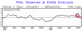
...now gone ... The GEF based telecon lost the +PNA surge too - and the individual members, one can see why. It's like the hemisphere up and abandoned. Here comes spring D9/10 on this 12z Euro run ...Deep cold retreats N of 55 across Canada and everyone S of the border is above 0C at 850 with continental conveyor from NM to Maine... Talking low 60s in mid Feb sun - not what winter enthusiasts want to see/hear. The last 6 years have seen some eerily warm spell events in February's and March's ... despite years having snow storms during those months - understood ... - the frequency began increasing going back really to 2012... I remember April was 90 on Easter sunday one of those years. Anyway, not saying that is the destiny this month, but I have been kind of waiting as a sidecar for early detection in the long range. The AO is positive. The NAO is positive. The PNA is holding out, but lost the surge... If the latter slumps negative I'm not sure I see how we don't soar, given the "local climate era" - not delving into cause.. just monkey see monkey do
-
This is a spring blue bonnet special - assuming anything comes of it. Even a minoring snow accumulation is going to be dependent upon falling through that type of sounding you describe, and magnitude/fall rates ...etc overcoming. It's moving metric. Some locals may flip between light rain and moderate 'chutes ... May as well be late March
-
Glad someone else noted the 500 mb moves ... I noticed the 00z run ( actually...) had rotated the trough more neutral as opposed to previous - which at that time the model's surface evolution was fine relative to itself. But what made that peculiar is that despite more neutral tilt, and somewhat more coherent local DPVA contained, the surface reflection on that run actually trend more SE than the 18z (ugh), a motif it continue in the 06z solution. But, this latter runs seems to be introducing a second aspect: it's blossoming a new QPF swath over SNE/CNE [apparently] driven almost entirely by emerging frontogenics. The 06z was also continuing along the improvement trend at 500 mb that began at 00z as described above - even slightly more so... It may be, that is how we get anything out of this. The 'mid level magic' as it were. There may be some sensitivity there...where the more the 500 mb leads to more of this latter production sequencing.. For the record, this did not congeal in the guidance as I first visualized it could - but again again again..this was advertised as low confidence, for minor to moderate. At the time there was nothing better to do, for one. But, there was also decent ens support; in fact, spread was west with some members even down as far as the 990 range. Not terrible, considering the footprint flow. There isn't as much L/W --> S/W interference ( manifested as gradient/ velocity saturation..). It is interesting that despite that, en masse, the cluster moved away from amplitude, when @ < 108 hours. I suppose if that sort of correction needs to be made, you want it out there instead of on the morning of the event.. huh. These S/W's being delivered from the Pac are kinda "short-bus" material. It also occurs to me that some of the extension west of these NAM QPF layouts have also likely been related to mid level forcing - weak, however doing so with a PWAT loaded S origin..etc. Lot of detail migraines. Including also that the NAM hasna NW bias for EC frontal positions and storm tracks > 48 hrs. I've not seen much in recent seasons to suggest that is not true any longer. I just saw this behavior this season several times - though subtle. That said, the 06z was also a 500 mb rotation of trough mechanics, too, and smears QPF back to ALB. The Euro has cyclogenesis, but limits any mid level aspect to not occurring at all. It'll be interesting to see which..
-
HA! yup ...said the same thing earlier.... It's more likely than not that is a legit signal blah blah... obviously that run sees the horizon features like the magnification of the moon rise.
-
Yeah ... looks like the interest might be shifting more E-CNE and Maine ... But, the 00z could bring it back ...etc... Folks should keep in mind that weak systems of this nature could actually snow pretty dense because we mustn't neglect where they are originating. It's congealing out of that deep subtropical easterly fetch ENE of Florida, and then gets captured by a weak N/stream... It's really a phasing of weak mechanics ... but then captured, it's likely to be pwat wealthy. It sucks that this is prime time seasonal snow storm and this is what we got to show for it - it's all we got. Not the thread for it but the Valentine's Day system is again presented on the 18z GFS. I bothered to check the ens means and 2/3rd carry the membership on that, and considering the numerical telecon [ appear to be ] bringing a new +PNA surge over the horizon of D10, well... we both know it's a hemispheric look. It's sucks when the Euro does this prematurely though, because one cannot start a thread for that without those images getting in the way lol.
-
Heh ..that Euro run looks similar to a couple of sale attempts it leveled at us prior to the blizzard last week ... 3 days before hand. This was a 'carte blanche run' ... basically, it only sees the potential, noting else, so is free to ceiling. I like the 6-8"/hr band with lightning from PSM to HFD on hour 216 on Pivotal's rendition - that'd be a hoot. But the most eye popping aspect about this Euro run is that by hr 222, that particular frame would have severe winter storm criteria simultaneously occurring from DCA to PHL-NYC-BOS. Now that's hard to do that... Usually, it's tapering PHL S when it's raging up this way...That "artistic" carte blanche solution concurrently locks the megaplex - right out my 9th grade math notebook LOL


