Typhoon Tip
-
Posts
44,567 -
Joined
-
Last visited
Content Type
Profiles
Blogs
Forums
American Weather
Media Demo
Store
Gallery
Everything posted by Typhoon Tip
-
It might matter if “Mets” used those products?
-
The mechanics of cyclogenesis itself and related rising air motion, also lowers height; it’s not just the approach of the trough from the west. That’s what I was trying to describe earlier regarding feedback mechanisms… It’s one of the reasons why the 12z solution did not reach its upper bound is because of that dual low spread the lift
-
Agreed… I mentioned the same thing to Scott earlier in the day that it was pretty clear that dual low structure was robbing that run from its upper bounds.
-
Looks like this 'warm secludes' just east of the Cape ...not an uncommon attribute for upper tier bombogenesis cyclones.
-
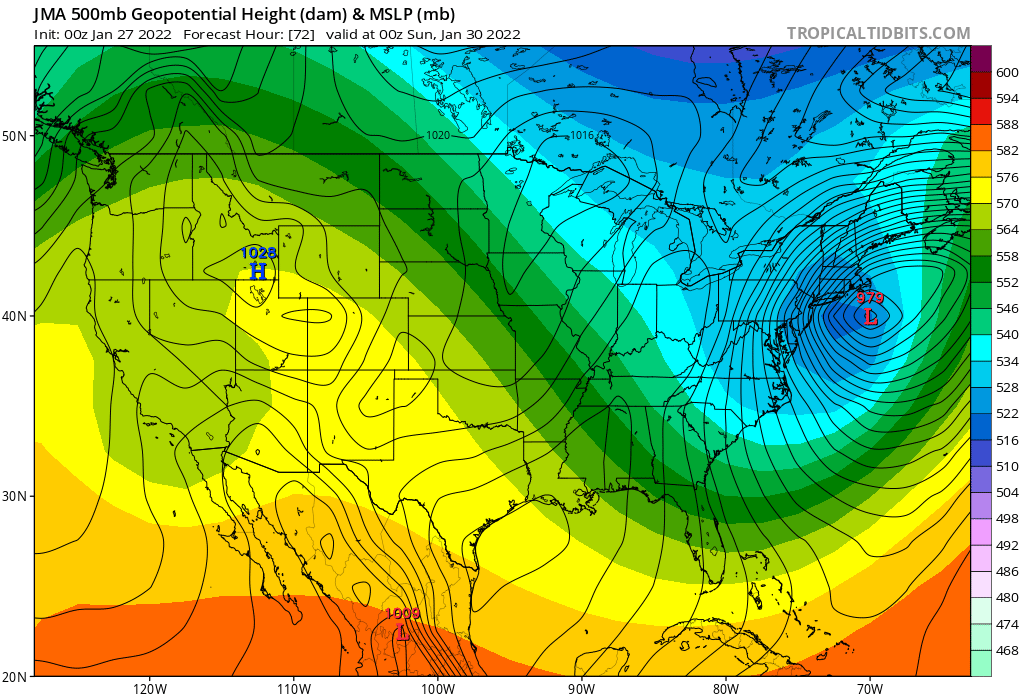
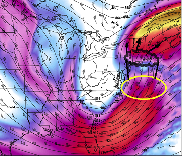
I suspect the Capital District of eastern NYS is the real western "edge" to this one - would not be shocked.. Using the 12z Euro ... which, it's accedemic as most guidance has this below, these are about as close to the idealized jet couplet paradigm for explosive snow shield expansion over/within the cold sectors of winter coastal storms, as you will ever see. This is the 300 mb centered on 48 hours (Sat 12z...). The models are definitely suspect with limiting how far W the snow shield will expand imho - The yellow circle is also the top of the evac channeling for the exit region of a 110 kt 500 mb jet curling around the eastern side and running up N of height falls approaching the M/A. These models should really have at least light to moderate snows expanding over that region of NY ...possibly as the western extent...
-
Heh ... good luck trying to measure 34" on Cape Cod with sustained 55 mph gusts into the 70s
-
I did... seriously, I'm a ******** .. well, I am but not of this. This thing's U/A mechanics are superb.. the lows have all been situated too far E of that mid level forcing. That can happen, but I am noticing a definitive trend to keep the 700 to 300 mechanical structures at longitude/latitude scaffolds, while successive runs fight to inch the lows west to meet. I don't think this is done trending either, though dramatic shifts may be a thing of the past. This can afford to bomb closer, and if/when it does, those feedback height falls from that processes will encourage the collocation of the mid level features, and all this ends up correcting to ACK in my mind. That's just farmer Met John's hot take, but it is where my visualization resolves this for the time being. I don't see this modulating enough to change that perspective, so it could just be wrong. Just sayn'
-
yup ...I wonder if that's also robbing it from being deeper. It's just got incredible deep layer jet structural mechanics... 980 ...um. Don't get me wrong, that's nice and deep and all. But it seems this 'higher upside' aspect that this has had, really all along ... , is leaving something out on the table. So did the NAM for that matter, as that weird dual low aspect sort of pinches off maybe 20% QPF from getting back W
-
They're all doing that, as performance relates to this particular enigma. I'm not sure what is real vs fantasy anymore. Those with varying wit as to how to interpret /categorize and analyze these models, are actually in a form of information overload. There's no way to analyze all that is available from just one model, in just 6 hours, before the same buffet's served all over again ...Yet there's like some 8 or 12 sources. Yet, every little "tick" ...as the vernacular comes to call them, triggers these response explosions, the thread increases page numbers by 4 or 5 inside of 1/2 hr. The problem is, there is hyper sensitivity and focus that's beyond the performance of any model really. So the disconnect seems to be where fantastic "expectations" are in a disconnect from reality. These models were not going to show 18" every run, for 7 days... People say they know that... then go along and behave manic anyway - I think showing 20" every cycle, even at 2 or 3 days lead, when there are run 4 times day, isn't likely to happen.
-
pretty much perfection - you can't really 'expect' the models to better draft out an illustration - if you do... you really are in psychosis for expectations...
-
Also depends on what metric we're focused upon when making that distinction in post-storm-mortem. Obviously to this group/social mediasphere of contributors, there's bit of a focus-bias wrt to snow. But like you say, capture and location, lenth of time, and at what time along the gestation of the event, are problematic for much more than snow. Grid concerns, tidal flooding, and even straight up wind damage ( more coast and SE zones), add to that 'historic' framework. I'm just trying to be more broadly inclusive. The tide Saturday night should be astro lower, but still high, without a storm... Tough arithmetic, when sig wave hgt guidance has routine 30 footers, what ...10 miles off Harbor entries... I would not want to be a master or super of any marina from PWM to NJ Saturday night, with a 968 mb low temporarily stalled, or even retro ... That's the other thing, if the capture/stall stuff gets more proficient, it may actually manifest as a loop, send additional momentum that way. We could end up with CF problem that ranks, with significant grid problems SE of ASH-ORH (~), and only 15" ... It's still probably arguable as a historic event. Also, these pressure depths being put out... if this really gets down 963 or whatever... I can't find a Nor'easter type coastal of this nature, that deep. Lol, watch this break records and be forgettable.
-
I’ve bitched about this before but situation like this really underscores my complaint… Why did they discontinue the model diagnostic division- … now would be a good time to see if there were data ingest/ initialization issues.
-
And yet it somehow routinely scores highly. - bizarre
-
What a mind f*!k I mean it’s not just funny… When you get into 20 inches of snow and 50 mile an hour wind gusts and Ts the teens you got to get that shit right. That’s the difference between like the UKM the GGEM and the EURO versus the GFS. Shit even the icon is west. And we’re going to France approve it they are too!
-
I have a hunch that the GEFs are going to be west of previous nope.
-
That’s weird… The whole time I can hear the movie ‘the day after tomorrow’ on the TV in the other room. Just realized. Good omen? lol
-
And with the upper level low kind of dragging its heels behind it may actually get into that light snow for hours and hours.
-
Crawls up the arm of the cape over six hours pretty much S+ To S++ the whole time over the eastern half of southern New England, while it’s impossible not to get 50 mph wind gusts. I mean you can’t bum that description because the model is bunning itself. Interesting
-
Yeah it’s been pretty stalwart actually. Hasn’t budged. Not sure what to make of that actually. Don’t follow it enough to have that kind of feel for it but for some reason I bother to look at it for this thing and I can say It’s been like this for at least three days - it only goes out 24 hour intervals so we end up in between and all that shit too
-
Just for the fun of pig piling the GFS even more … 00z JMA is pretty close to flawless
-
I don’t know how anybody can discern anything out of that finger paint …wtf is that mélange
-
Euro came 1/3 too 2/5ths back actually.