

Typhoon Tip
-
Posts
44,567 -
Joined
-
Last visited
Content Type
Profiles
Blogs
Forums
American Weather
Media Demo
Store
Gallery
Everything posted by Typhoon Tip
-
OBS/DISCO - The Historic James Blizzard of 2022
Typhoon Tip replied to TalcottWx's topic in New England
Back on pg 8 of this thread as I supple from a cozy cup of coffee with a side of hotdogs. Beautiful storm on satellite... HUGE being if perhaps the most distinguishing aspect. wow - Snap comparison: The GFS from 00z is/was biased east, comparing to the ~ 12z sfc analysis by WPC; the 1042 Z analysis ( 6:42 am: https://www.wpc.ncep.noaa.gov/sfc/90fwbg.gif ) to be precise.. The GFS appears to be seaward biased by a considerable margin with its 12 hour position. The former ( time sensy..) is clearly showing a well formed, and perhaps most important aspect of all, NO F'ING DUAL BULLSHIT LOWS.... , stressing the lower/sfc cyclonic structure. Now, ..that does not account for the 1:18 hours between the time of that analysis, and the 12z model depiction found here, https://www.tropicaltidbits.com/analysis/models/?model=gfs®ion=us&pkg=mslp_pcpn_frzn&runtime=2022012900&fh=12 ...but we're only talking a 1 hour and 18 minute offset. The is moving N by NNE, just west of the 70 longitude, and it appears this error between it, and the subsequent GFS recent runs of obsessing stretching and dual/triple lows ... are destined to grow ... as reality slowly sinks the Samurai sword into the heart of the assholes that developed the Good For Shit model! Sorry...need to vent. More objectively... not declaring so...just a suspicion based on these present evidence - also knowing Meteorologically what is happening to drive this thing along. -
Lol Nah no drinking over this way. I didn’t edit that it might may be my phone doing some interpretive assistance
-
You can see this thing explosively developing already …wow judging by radar it’s west of guidance? But I’m not really sure I didn’t actually measure this point to point over this early part of the game. I just get that feeling looking at these echoes moving parallel to the Va Caped not northeast like the GFS … Probably should move over to the Now cast thread Also the euro came west at 18 Z pretty much gives us a beast blizzard to Boston musta been posted. talking big wind gusts and 20 to 28 inches of snow… It’s hard to say down by NYC maybe half that much. Like I said I wasn’t buying any of those runs earlier in the day I don’t know if that means it’s going to reconsolidate into the love of our lives and all that jazz but I don’t think it’s Diana Roma possibility that those were red herring model runs. We’ll see. Could’ve been a uniquely prone error for effective sensitivity and all the models were guilty of it but it’s really really difficult to actually believe that, I admit that
-
Well thank you but .. I didn't really say 'algorithms' haha. Okay though - I simpler terms,..the models' convection parameters might be to "too smart for their own good". They're sensitive, and the region astride the EC is a powderkeg at rest state ... pretty much at all times. It may ( metaphorically) overwhelm the models, such that they get carried away - faux convection. This is an area of physics that is a little different that tracking a S/W, and propagating them through a field. All the models can really do is set up instability - budgeting where convection fires gets down closer to chaos. They can't really predict that, and the convection we have been seeing, what they are using to developing the dual/triple lows, may not exist in reality... I mean there will be convection out there, but the models are creating it, and relying on the created mass to direct their results...
-
Yeah ..I don't get that. are there conference calls they didn't mention with NOAA head quarters -what... dunno. That doesn't seem right.
-
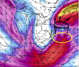
Post of the thread in my opinion ^^ I've posted the same image my self scratching head like how in the f is this thing not spreading more snow farther W with that 300 mb evac fan.... Next run, even more bullshitty - I dunno. Chalk it up a sometimes weird things happen I guess.
-
Folks are probably going to be a bit engagement fatigued for awhile but fwiw, there's another signal brewing D9-12
-
Not buying this solution either... Continuity blows harder than the winds being modeled - At this point I'm resolute to rely on now cast. Stay the present course on current snow and wind coverage, and adjust down(up) accordingly. I realize television talent and back-office officials don't have that luxury when it comes to advising the public, but get creative with the language - some times ya gotta do your job. Heh. Something like, "I apologize that I cannot confirm the higher end of the snow fall potential at this time, but the potential is still there. Pleas check in regularly as we will be updating this to keep you informed, as the storm's impacts become more clear..." sumpin' like ghat -
-
You know this obviously ...but it appears that outward ejected low is entirely convective driven.. .Maybe just add that the antecedent fast mid level flow exiting the coast assisting evac? Like it's interpreting that as the cyclogen domain space.. blah blah, but barring some exotic explanation, that above really does strain believability - all this potential just blows up into fractured elements like this. 700mb displacing here... premature lows half way to England.. Snark but just sayn'. ha, maybe the storm got too powerful ...like a battery over-volt explodes.
-
Okay...I'm changing the title of this thread... Powerful Multi-regional/ multi-faceted pain in the balls storm, no longer a matter of confidence - it's happening: 30th, MA to NE, with snow and mix combining high wind, and tides for everyone yet no where I don't know what's more epic. This would-be storm, or the pain in my balls. Supposed to be tomorrow... just one day, and the models are still fumbling around humping any possible tedious nuance in order to not know what is happening. All these advances in the technology ... might as well be 1980
-
Funny ...was looking at the 24 hr, 500 mb layout just last hour ( 12z ...). All models depicted the western N/A mid latitude ridge pretty far west. I mean the whole eastern structure could theoretically afford a position back W of where is such by some - yet ...allowing for that, the models then find a way to stretch even more seemingly theoretically impossible. haha awesome
-
Agree with Scott .. but again and want to emphasize, the fact that those subsidiary low move around from run to run, is telling. They don't exist; they "might" in the future. They are entirely AI generated as a function of the powderkeg out there. Basically what that means is, we are reliant on those model induced 'fractals.' The only trouble is, the models don't predict the future emergence of those - not really. They predict future states based on input parameters, but not the spontaneity of new events. One run has the dual low here...then it's there. Then the yet another run doesn't have it at all. All it really signifies is that there is saturation of volatility. I think also there is some truth to the notion that the models are too good at detecting that volatile states, but are at a limit as to whether a thunderstorm complex will feedback or not ..etc ( to put it simply) so we're getting real coin flip results.
-
This is really turning into an intolerable situation for the MA offices, up through NYC ... This series at 12z basically removed them from even winter storm warning criteria - arguably .. - yet they were cooked into believing a blizzard was en route. They have blizzard headlines down there that frankly, don't have a prayer at verifying "IF" this 12z Euro had any say. And if these are right solutions - the elephant in the room is that the models, et al, could not get this right at 30 hours - although, does the GFS re-enter the discussion there? I dunno - might be right for the wrong reasons in that case... separate headache.
-
Right - I'm not sure that has to be correct, either ... the forcing was back SW and it seemed to deepen too far E 18 hr ( so very short term) now cast it
-
Yup ... no objective doubt about it - It seems to me - if hypothesis ... - these models are almost too sensitive to convective signaling, while not really be as good as some claim at resolving what is real versus model-fractal triggered ( for lack of better phrase...). They seem to create convective trigger points, or "pull them", then blow them up... but they differ from run to run where? That strikes me as AI imagination ( again, for lack of better phrase...). Otherwise, they'd be relatively fixed and reproducible. This is evinced as true just looking at run to run variances among the guidance ( within their own - ); they are not consistent with where these dual or even triple cyclone nodes are originating, then nesting run to run. The NAM just sent us 3 consecutive cycles where it had much less of those shearing nodal points... now it has a big one out of no where? The NAM may not be right before that even happens... yup.. But, I strongly suggest that it is just responding to this abv sensitivity on this particular run, and I wouldn't trust it. It's not enough to to think, yeah but that the GFS has the stressing low ... or RGEM ...whatever. Because the guidance don't actually agree very well on where these subsidiary vorticies actually position - It seems just as likely to me that we are being given fantasies over all by a technology that has become "too intelligent for it's own good." I could see the next run of the NAM sans that and put us right back to the 00z/06z type nucleated return, just as easily. Than we're back to just doubting the NAM in general because it was a piece of shit before having this discussion to begin with ... LOL. But anyway -
-
We mused last night ... maybe "James" would be better -
-
Yeah... this run of the NAM does little to motivate me - personally.. I mean I've seen this kind of antic from the NAM < 48 hours, where it tosses a turd cycle into the punch-bowl, only to correct a cycle or two later. This run appears to be just a 'slightly' unraveling of the 06z ...and immediately, we see a ... I dunno 20% reduction in the 'awe' top side. In a philosophy that's fine, because the previous solutions were sorta kinda 'off the reservation' relative to climo to an uncomfortable extent. That said, the "upside" aspect of this is still there - so we can't let guard down as to how much this could come back... Side, RGEM...GGEM and Euro ... Wouldn't it be funny if the GFS came in with a 30-bomb clear to HFD - haha
-
Agreed ... I'm not "sweating" these peregrinated model solutions like this... The situation is sooo sensitive to those convective feedback processes. It's really like it's outside the technological ability of the models to figure that out ahead - almost fractal/chaos ? you know - "if it happens, it happens" When it doesn't, we get 00z NAM-like solutions. When it does, we get GFS. GFS has been wholly and totally committed to pearling lows all along. It's clear that "its" feedback dumbs this from a magnificent to just above medium impact. I dunno -seems this is the deterministic rub with this particular storm - the unknown wildcard. Like we joked before, "we can be 100% that we are going to the casino; what happens there, not so much ...
-
cool! was thinking we should fire one up - the entry into this is today frankly, with b-leaf snows breaking out all over the OV to PA and entering western zones and overspread; we are likely to get currier&ives light snow under street lamps this evening, ahead of the main show. But it's all really keyed into the same larger synoptic shenanigans - yup
-
In principle I agree. They "seem" ( I do not intend to impugn NWS with this statement ) to be weighting conservatively; I have not read their AFD so won't speculate on there philosophy for doing so.. But, I believe this system has an above medium potential to verify blizzard from ASH-PVD, and points east. In addition, I also feel ( much to the delight of intents and purpose consensus haha) their snow forecast might be too gradated from E to W across the region of SNE. I don't have a problem with 18-24... but 10" at HFD looks heh - It is too possible that mid and U/A jet coupling, ... blossoms snows farther W than guidance, where there is likely to be > 15:1 ratios - I'm brave though and don't care if I f-up LOL... no seriously, I don't have an reservations about going higher say HFD-EEN. I see a moderate snow field spreading/fanning W -N to perhaps the Capital District, with some modest banding/meso enhancing striations there W of HFD arcing to Brians, and that may last 6 hours at nearing 2"/hr
-
Once again ..I'm a few pages back this morning... so this may be redundant, just my take: The GFS solutions have never consolidated this system very well. Despite late attempts to finally conceded to a better centered structure/west, beginning perhaps 18z yesterday, the 06z seemed to get stuck to me. It appears to be 'stretching' the system apart as an insistent model cycle after cycle result, and it is effecting it's maxing - example, those multi- nodal cyclonic pearls out there ( which appear dubious to me). Thus, subtracting from the total. It's got a anchor-point low situated back where ( in principle at least ...) the NAM and Euro have their "main" low at 30 hours, but it has perhaps 2 nodes rippling out NE and accelerating away ... one SSE of ACK, and another more discerned due east of Cape Cod at that particular frame. That shearing/smearing NE out there is related to why heavier QPF/ .. placement thereof, can't get farther west. I can't see where to correct that , because it seems like the model is constructing a 700 and 500 mb surfaces to allow that to happen. Contrasting, the NAM and Euro don't do that, as much.. The Euro does some aloft 500 mb weirness, but the NAM is strangely nucleated at 500 mb. Hmm..but, with these mid level attributes, they appear to in turn maintain more consolidate/west lower tropospheric response(s). It seems the convective sequencing and how those can feed back ( not calling this convective feedback, per se) is the new sensitivity in this thing. Prior in the saga, it was 'How would the N and S stream ultimately interact', subtending the western ridge of N/A ..etc... Now, it seems that's settled. But we've relayed one uncertainty into a conflict among these model types as to how complexities inside the system's gearbox will play out. Convective physics can/do vary from one model type to the next, and latent heat budgeting therein may be relate-able in this.
-
May seem "bunny" of him, but I sat nonplussed at what I was seeing last night.. And now the 06z Euro and 06Z NAM, if anything ... upped matters. It is as though the models are trying to realize, in the short term, the higher than normal 'upside' that's been a part of this thematic arc the whole way. We've been saying that this thing had room to become a juggernaut.
-
Why not name this storm after him ? I mean it’d just be something that’s native to this sphere. But hold off naming until post storm Mortem … you know, to make sure it doesn’t turn to rain or something on the Cape
-
I would argue this storm could rival intensity, too... We don't have a 1045 high N of MN with arming into eastern Ontario an over arcing +pp like back whence, ..no. But, that went down to 984 in a higher overall ambient PP... So how do you take it, and put it in this ambient pressure pattern - what is that 970 ... 972, 966? This may very well nadir into the high 950s! against a 1032 mb high. Hmm it's worth discussion. Talking 76 mb of static gradient, with 925 mb winds nearing 80 kts... The wind machine is comparable. Conceptual white board: This is a Miller A capture/subsume by a N/stream short wave... 1978 did that ( different set up leading achieving the same result) but not as coherent as this is (likely ..) destined to perform. Why? This is no mere weak wave E of Georgia getting foisted N. This an obvious theta-e saturated cyclone that goes through that special steroidal treatment. This won't likely stall like 1978...which protracted impact - that may stay '78 as mastery because of that one fact. But also, we get into the whole era-relativism where it was more obsticular to that state of society then ( 'obsticular' ... that seems like it should be world LOL ) but you know what mean. If this thing stalls and manages to get Sunday morning's high tide involved, we're easily in big big trouble down there...
-
Did you have to snap off the screen shot at preCIsely the moment he put down the bong -


