Typhoon Tip
-
Posts
44,567 -
Joined
-
Last visited
Content Type
Profiles
Blogs
Forums
American Weather
Media Demo
Store
Gallery
Everything posted by Typhoon Tip
-
This run has huge glaring issues with convective feedback. It appears to cause premature focus …way removed/ahead of the synoptic forcing. It strips away an early low toward the open Atlantic …stealing away the baroclinicity long before the real trough has any chance. Not sure it’s right … as that word choice would suggest. Ha
-
Hm .. I think what this is showing ( me ) is that yes, the ridge in the west is becoming more stout/upright in successive means - that's "air" apparent ( n'yuk n'yuk)... And down stream, where that trough nadir is, it's really more about establishing a "correction vector" toward more amplitude - again... where is the f'n operational run. This is mind-boggling at this point, because almost invariably, ... the ensemble mean parrots the operational version - they are typically more so nondispersive they make people physically frustrated. So this is anomalous in general, but anomalous relative to that performance arc.
-
Part of me keeps visualizing this getting grander ...and sort of growing down the seaboard, as a major up this way becomes more coherent.. like each successive run, brings the QPF back SW... and we get back to the original solutions with this thing. Proving the whole saga is ( same old saga) just model peregrinations. I could see that ... Not forecasting that - yet. But I could see that happening.
-
I would like to see either: - the Euro send along one big solution ...even if it wants to return to it's weird beedy-eyed obsession to deliberately not create a cyclone out of this, if it did that just once that has value in this. - the GFS return to one of those previous big nuggets ... again, if it wants to go back to sleep for a couple days. Those would be tells - they aren't absolutely necessary, but fact the matter is, neither of those two models are going to bust at 2 days lead as dramatically as they are presently parting company with their ens families. So either the means will go to them, or they will go to the means. The funny thing is, the 12z GGEM is the only operational model that looks the most like it's ens mean at this point. I suppose if this ends up being the storm of the season ( thus far..) we'll have to remember that in post-mortem
-
Fwiw - the GEPs mean is considerably west of priors at 12z. Like the GEFs, it carries some exotically deep solutions almost nicking the outer arm of Cape... It's very tucked... Also like the GEFs, the deeper members are tend within that NW spread
-
Sorry ... I was watching NFL ... but the ICON extrapolates to a very deep powerful solution somewhere between the Del Marva and Cape Code. I realize this model is both unproven, but not doing well in pursuit of that evaluation - either - but I'm sure someone's already mentioned.
-
More impressed - personally - at the bodily shift NW of the entire suite mean, and yet ...there's still moderate spread NW toward Cape Cod, with some members down exotically deep. The operational version is a pretty dramatic outlier at this point -
-
That actually takes a significant amount of member ballast to move the mean that distinctively ... The operational version might be a pube better than the 12z stinker it gave us, but in terms of whole-scale indicators, that ens means huge by comparison/significance. The operational version is odd.. But the Euro vs it's ens mean is sort of doing something similar - tho I don't know about magnitude- the mean looked better than the functional version.
-
JMA is naked stripped down model. A purer nonhydrostatic projection … not as gummed up, it’s like exposing a basic look at major physical kinematics effecting a system outcome - I think.
-
I was just looking at the GEFs mean trough on this 12z at 144 hours, and comparing it to the two previous. It's interesting because this run has it deeper, and more W, ... Meanwhile, the mslp/members product is showing the pressure contours continue to bow NW where there are very deep members in that spread vector, around that same hour. That's intriguing...The former being more west ( deeper no less) ... sort of gives opportunity to the spread members to be on to something. I just suspect this not being inside the Euro wheelhouse of < 4.5 days may not be ideally advantageous for that particular model. So there are some moving parts in the early determinism philosophy here -
-
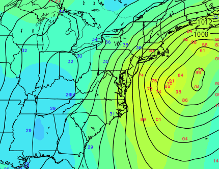
I was just referring to the coarse product at Tropical Tidbits to make for some humor.... Still, it took a ..I dunno, 996 mb low near the S.C. coast, and 24 hours later, it was like 960 in the GOM... In order to get between those two locations, while heights fell some 30 dm at the trough core in stride ... means their somebody gets that ass handed to them
-
You know a model is giddy when it's graphics are so intense one can no longer make out the state lines... It's like in Space Balls, "We've gone to plaid!"
-
Well ...it was at the time, relative to the synoptics.. Frankly still is a reasonable solution - huge this or that imby, aside. The synoptics can change though, and that would render that not such a good fit - so...it's not a 'you're right' or wrong ...I'm not using the JMA for any determinism by using it to make a joke with. Lol
-
Let's do a model prediction head game ... Euro - comes in at 12z with no storm at all. ...that's a neat trick. Flattened so much that ECMWF head-quarters must now face the moment of decision: do we take this p.o.s. off line and APB a disclaimer. They opt out, because ( phew!) it's absolutely nailing the highs and lows out in the middle of the Saharan dune country of N Aftrica, and they can always fall back on besting all other models "where it really counts" - there, and 75 mi N of Utqiagvik AK, and the regions immediately adjacent to western Europe. GGEM loses it at 00z, but ...being the GGEM ..that's kinda okay? We know that it's kind of like Ralph Phillips from Looney Tunes ( kinda like George01 in a way now that I think about it -) and we just pat it on the back, and it goes, "..Oh, sorry," and it jumps perhaps 70% back on board tomorrow morning.. UKMET plots bombs between the BM and Cape Hatteras and ALB, but wins the best aggregate/ n- placements that happen to average out to the best scores. But we like that..., because it offers solutions for the subversive trollers when they need to reach for content, but also delivers the best support in closing arguments of the equally irritating over-optimists... GFS ... is just an asshole - what do we expect from an American A.I. design. I mean, art reflects the wielder of the paint in that sense. JMA is under the radar perfect on this one storm ( see yesterday's 12z ..which ironically, is the best conceptual behavior that fits everyone's salient critical observations..) *but*, since it has been perfectly wrong on everything else ... like ever, it never set its self up to really be seen. ICON? ... anyway -
-
I was describing the ridge morphology and how it looked to me like some guidance were stretching the L/W trough down stream of the ridge too prodigiously, to JC' ( heh, gave him some 101 diagrams because I am an excruciating nerd lol)... but, I'm all for any run that does not stress that geometry to the boundary of believability. I say again ...the flow winds at basal state are slowing, and upstream...the NE Pac is entering the AB phase.. Those two are likely related indirectly, but should factor in how the trough orients E of ~ 100 W across mid latitudes. I'm not trying to be some Gomer trying buck for the amp runs. Tell me where that's wrong.
-
Massively underrated post, folks ^^
-
Yeah... ( personally ) not really motivated one way or the other on this ... exactly where I am at thread start - plenty of room for this thing to tact along with the western members - which by the way folks, that spread contains all the intensity ( for the most part...). That's telling in the sense that intensity of the S/W feed is very important in this thing. Brian makes a wonderful point about that... And not attempting to take from his insight, but I mentioned that a couple pages ago ..the overnight runs seem to be waffling on that handling over the continent once it is delivered off the Pac in ...96 hours ( like uhhh, that too -)
-
Probably behind but just saw the jaw -drop 500 mb synoptic evolution of the GGEM ... wow
-
Ha ha... I didn't even look at the sfc evolution. ...I mean, beyond the idea that this is the ICON at 120 + hours... I didn't like the 500 mb V handling and got pissy.
-
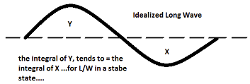
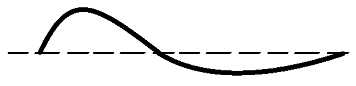
Sure ... ... for L/Ws left unperturbed,they will tend to become orderly and symmetric like above. When L/W are no longer in stasis... i.e., a S/W space enters the left side and propagate through, it will stress ( 'stretch') this shape, and the symmetry is reduced while that is taking place, but since mass in the atmosphere is not lost or destroyed, the integral masses will remain the same - constantly being restored by the wind/air motion... So, using this basic precept: our ridge in the west bumps maybe a half a time-zone E, just because it too is answering to outside forcing. But the short-wave spacing that it is propelling out ahead ( the driver for our 'would-be' storm of interest), runs out ahead by almost double. It can happen... because the long wave may simply end up taking on an orientation like this, See.. here the 'Y' region in the west, and the 'X' region in the east look less mirrored, but don't violate the integrals ... The trough is pulled in the west to east direction ( which I called the x-coordinate) ... that may not seem problematic to the lay-person, but I don't see why the stretching has to happen at the end of this week, because: Stretching can happen and does when the flow is fast. However, the flow as modeled appears to be slowing. Seems that's a little off... ( maybe-) to pull that flow structure. There is a strongly coupled relationship between long wave structure, and the short wave structures that modulate because of the former. If this L/W is being pulled in the east to west direction down stream of the western ridge, too much, than it will feed back negatively on S/W entering trough part of the total L/W space in the east.
-
Full disclosure my way ...I'd call the purpose of this engagement a success if while we close the gap on days this remains relevant. The purpose of this thread, to put it nicely,... is the philosophy and recognition, early synoptic super structures and those facets therein that lend to increasing possibilities. Going to the casino to play the game of chance can be a certainty; whatever happens there is not. We should be able to maintain some semblance of cogent categorization, and not behave as irresponsible throngs storming the White House as malcontent nimrods. And yes ... of course, snark and jokes are always welcome lol.. But, just to be clear, it's not intended for assessing whether a system impacts one's back yard, nor to advance any expectation for week's worth of dependable d-drip on some kind of e-psychotropic cinema addiction. If those are the expectations, your likely to be disappointed more than stoned - just warnin' 1 .. high confidence for a significant event, for one analytic, the other symbolic. Analytically, this system has a deep history in the ensemble means. It really began ( arguably...) showing up when this was 300 hours back in the day. I remember commenting that there was a large signal beyond the two events were covering at the time. Symbolic and a-priori, bigger events in the atmosphere, sometimes show at unusually long leads. It seems this system festering in the clusters regardless of where, might be a candidate. 2 .. where is in question - not trying to cop out. I was clear last night that I was not sure what to make of the yo-yoing gong on between west and east positions - but it's also f'ing D8 at the time. I will note that the Euro has yet to put out that big dawg solution. I almost wonder if there's a sneaky value-add to see that at least once, ... before of course it summarily then loses it as though ECMWF corporate intended to send the psychosis meter pressed toward the fever pitch end - I dunno, maybe they're just trying to find the best time place the tack on the chair. Ha! 3 .. there are still reasons on the table for the present overnight EPS/GEFs means to plot back NW ... Lest we recall, just prior to the last event, these guidance were persistently situating deep solutions over ACK to the BM, run after run ..after run, and it ended up W of the Hudson. Not sure this won't eventually manifest that same sort of error. We are heading it would seem, ...into an impressive -EPO. In fact, the event in question happens as that is emerging. That's interesting ... Even though the block associated with the former, is where it is, and we are way over here.. that does provide and interesting non-linear suggestion for subtracting the W-E bias of the field down stream of it. That's a fuzzy concept for some most likely, but just think of that as systems down stream respond to a more N-S exertion that isn't really observable on the weather map. This is advance wave mechanics/theory, non-linear forcing. Linear wave forcing is when A --> B --> C ... D, directly, but non is when A --> D, but B and C may not observe any influence. 5 .. it has a bigger risk upside than other systems this year, so at 50/50 It has that 'it' factor, where if things come together, we're likely seeing a system evolve pretty far above the mere middling. Those are deterministic values for now... My personal observation of the overnight is that the < L/W mechanics spaces are also weaker. Weaker in this scenario is not helping matters for west enthusiasts, because a stronger system would propagate a S/W ridge component out ahead, and that would help feed-back toward the left. Also, I'm not confident the flow structure down stream of the W ridge is handled quite right - possibly related to that. It's not progressive, so it gives the allusion that the runs are trying to stretch the L/W into an less likely X-coordinate length.
-
This run compared to last run … if you click back-and-forth you can really see how the sensitivity is purely related to the progressivity of a flow (less to more); in any one of those paradigms there’s a significant storm and possibly a major one …but it where? It comes down to a matter of that maddening yo-yo with what’s surrounding it.
-
This is a long lead heads up for a potentially strong cyclone over the eastern U.S./ .. western Atlantic, only. That said ...it has enough presentation in the various model clusters, and persistence too, to initiate the focus. Though we are far from a deterministic forecast, this system hm has some risk upside. Short list of notables: -- this potential begins 7.5 days away for N GA, and perhaps exits Maine D8.5/9. , ... It's not impossible that this system slows down ( more blw), such that it's into the 31st over the NNE/ME. It is also potentially a larger system size. By virtue of that alone it may take more than a two periods to completely finish a location. -- as that suggests, this may impact multiple regions from the interior SE U.S. and up along the I-95 megalopolis to SNE, NH and ME. This is a fluid interpretation/subject to change. But when we get into multi-region, multi-faceted systems, even a moderate storm aggregates a major problem. -- may want to check tides/ lunar, as this system may be ISE loaded and should it slow down... it may protract across more than a singe tide cycle. This type of storm, we have no observed in recent years. Unlike last January, when the super synoptic manifold entered a slowing of progression, with relaxing gradient, but no embedded mechanics, this appears attempting to do so. Concepts: We've been monitoring this for a week now, and thus it has established history. Sometimes important events show up at longer leads ... and keep re-appearing - I've been wondering if we're living that. That would be true if it hits a backyard or not... Slowly the various ENS means have become more ominously suggestive. The most recent runs of the GEFs and GEPs ( 18z and 12z respectively..) were still continuing along favorable trends, well established spanning multi cycles. The sense here is higher than model-climate odds for a significant system. Where it tracks, I have a couple concerns -- I am noticing the sensitivity is very related to the progressive, vs slowing ( timing this latter arrival) of the flow character. Whenever a guidance cycle has reverted back to conserving the progressive character more so, we end up with runs more so ... like the 12z GFS and Euro. When the subtle pattern change to slow progressivity is apparently directing a give model cycle, we get are bells wrung like the 18z GFS... Not sure at the moment which way that will go... I am also noticing there the flow structures over SE Canada having effects on model runs, but that may be related to those same aspects. This about 50/50 right now. If progressivity persists, this ends up east. If this leitmotif in the ens systems to slow takes place, it would be west because N/S meridian tendencies are increasing, and the system ends up farther W. My haunch is that the slow idea is real... how much? It could be damned in between! ugh... But, if we look upstream, there is an emerging -WPO/-EPO out there D6-10. That is blocking ...native to that tendency, progressivity tends to slow, and the meridian aspect manifests. So that's were I lean presently.. We'll see -- Plus, there is also the S/W mechanics them selves... If there is more N/stream insert, we may see a subsume phase... vs less, like this 18z run. 18z is a purer Miller A. Should the this slow down and trend Miller B, this is a bright signal and that would likely manifest with equal prominence to put it lightly. But much of this is also indirectly related to above, as those are larger waves creating constructive vs destructive interference nesting. -- The other aspect ...which is highly experimental.. I've been noticing that the last two significant systems we've covered had a tendency to be too far E in ens means, at this range... and eventually, clusters conceded to the higher resolution/physically tested operational version.