Typhoon Tip
-
Posts
44,567 -
Joined
-
Last visited
Content Type
Profiles
Blogs
Forums
American Weather
Media Demo
Store
Gallery
Everything posted by Typhoon Tip
-
Winter storm for the 25th of February is imminent.
Typhoon Tip replied to Typhoon Tip's topic in New England
GGEM really has been quite striking with that front side/IB signal - more so than the other guidance. The GFS structures it's frontal positions and jets ( multi layer) in such a way that it could easily be as robust as the GGEM, but is probably lower in total QPF - I'm est - just by eyeballin' the art charts... I mentioned this goop at the onset, but my primary concerns are the source/origin of the deep subtropical ingest into the TV baroclinic wall...then, as that overrunning axis lifts to climo position S of LI ( assuming it stops there lol ), it moving into a position where the polar side is collocated under a very powerful 300 mb exit region/UVM mechanics. Strikes me as opportunity for QPF 2nd guessing... but we got the week to iron it out. -
Yup ...all apologies conferred ... I looked for a thread this morning and did not find one re late week. I did mention recently I was intending to start one if I did not see one by this morning... I looked for it, didn't see it. May have been a timing thing - both doing it..
-
Winter storm for the 25th of February is imminent.
Typhoon Tip replied to Typhoon Tip's topic in New England
Oh shit -- sorry. You didn't have to do that. I swear I looked - I did not see a thread yet. I did mention the last couple of days I was intending to do so but I kept getting pulled away. Ugh. Last night it was late ...too tired.. so I suggested somewhere pg 114 of the Feb tread that we should fire one up and that I would if someone else hadn't done so by morning... I just didn't see it I guess. -
Complex hemispheric mode changes appear to direct a winter storm across New England; time concerning is very late on the 24th entering SW areas.... but mainly spanning the 25th for all. This even is > 50% likely to occur. Short version of important characteristics: -- "Day 5," some latitude in these distinctions is obviously required -- large spatial dimensions and nuances in the system morphology as its bag of tricks evolves through, may mean a longer duration event relative to the speed in which this thing will be smearing along. This may touch a lot of the region. I would not trust QPF limitations due to mid level mechanics - more belw. -- first as an overrunning stripe with probably icing headlines in the MV, expands along E-W axis over late Wed thru Thurs throughout the OV. Very proficient QP band with snow/mix/ice/rain, N-->S, will likely be situated from OH-MA overnight Thursday night thru Friday. -- relative to synoptic mechanics, expect > normal/climo qualitative precipitation, which could even go above QPF. This if for two reasons: I wonder if PWAT products are entirely correct - this seems it could actually be more laden. The 850 mb trajectories are deep subtropical origin in the Mon/Tues. The other aspect is that as this GOM miasma is foisted N and lops over into the isentropic lifting column on the polar side of the boundary, there situates in tandem a very impressive lateral exit region of A 300 mb jet that spans the entire distance from the eastern Lakes to the lower Maritime. That would really enhance UVM potential and perhaps situated banding/meso embedded in a ...well, getting too detailed. That 300 mb jet, and the general concept of bringing a "potentially" hefty PWAT air source into its lifting interface has really been on the guidance' for some time. -- It's 5 days away, notwithstanding... that said, ice south... mix pounding could results near somewhere between lower CT-RI to the Pike, but the particulars of total synoptic metrics as they situate in the charts ( for now) this is probably mainly snow from ALB-BOS latitudes. subject to change/get tuned... -- In all ..what is likely to be in ballast, characterize -able as an overrunning ( proficient one at that!) event, there are hallmarks in the idiosyncrasies that hint at weak Miller B/quasi in form. There is even some suggestion of lag back CCB, albeit week, postponing the storm ends Friday evening for eastern regions. subject to change/get tuned... Other concepts: We probably should not ignore the nearer term Tuesday-Wednesday event entirely. Both it and the following system in question are rooted in the same larger hemispheric scaled changes. As the onset of a -EPO then wave propagates into the +PNA mode, ...that total behavior ( spanning typically a week to 10 days...), tends to first shorten the wave lengths over the downstream continent. Brief primer: The way that expresses, ...a tall non-hydrostatic height or closed ridge nodes bursts over the Alaskan sector. Immediately downstream, the wave forcing nadirs flow out W ... --> heights rise over the SE/Gulf/SW Atlantic. The -EPO ridge/block's gestation then relays into a new height burst ... usually over the SW Canadian latitudes. The original -EPO either neutralizes, or a new one may take shape ( like 2015!) but there is a time lag between the EPO magnitude and the subsequent PNA. The 00z Euro demos that total evolution with superb finish... In fact, there's a conceptual signal from multi-guidance for more of a meridional storm event .. between the 27th and about March 4 out there, but... cross that bridge. The two systems this week, Wednesday then Friday ... are really like the same event ... only differentiated by their trajectory. The first is follows the above template by tracking through the Lakes. The latter system, by virtue of the -EPO --> +PNA, repositions the mean baroclinic zone farther along a S-E axis. These large scale changes can take place without Wed or Fri systems. They seem to be like 'going through the medium as the medium is changing' In fact, they have been presentable in the various ens systems, ... predating these index explosions were seeing now as having high confidence. But, the mode changes didn't 'damp' them out as they occurred. It's really been about re-organizing the circulation and conserving them in the field. Kind of interesting ... if exceptionally dorky LOL.
-
00z GFS substantially north at the end of the week… btw, ICON was 6-8” crisped over with ice at 00z - fwiw probably should have a thread going for this. Meant to set it up this afternoon but got pulled back into life. Heh. I will in the morning if that hasn’t happened
-
Betcha the next main cycle run of the Euro that D10er comes in more proficient
-
heh ...yeah, I wasn't mentioning it for my sake - really would rather not have it actually. no but I was after that right turning look to this. interesting. Granted, may not be using the best radar source - https://weather.rap.ucar.edu/radar/displayRad.php?icao=KENX&prod=BREF&bkgr=gray&endDate=20220219&endTime=-1&duration=2
-
Lol .. yeah, 'course... yet another way of looking at it, if a big solution is going to happen it's gotta start showing up at some point. There's no easy calls in this business - certainly not this year... I mean, some years, yeah ... you can kind of pick these up and a week or more out in space and time, and they'll behave reasonably well. Other years, they just won't. No matter how bright a signal is, it turns out to be the sun-dog and not the star.
-
Seems the trajectory of the heavier squall line is sort of behaving like summer convection in turning SE a bit... N of Rt 2 may be shafted.
-
There's actually some risk for that interplay/stream mechanics in that range ... That's a subsume model capture scenario. ( 1978 et al), and typically happens when the over-arching blocking moves over the N-W territories of Canadian. The problem is the flow is too compressed in the TV, such that when the N/stream SPV fragment attempts to come down, the uber velocity flow is stripping the baroclinic instability leaving only modest cyclonic response struggling to back west near the MA. The old Miami rule in full effect. I guess having 580 heights to Macon GA is a bit too hot for digging. Seems the initial tendency to tuck the flow back SW up through about D7 is causing the Gulf to ridge too much... I'm tired. I think I'm ready for summer lol
-
Man... the end of that Euro run was sooo close to fixing everyone's seasonal snow fall deficits
-
Depends on what we mean by colder - the antecedence is essentially negligibly different. The storm itself is modestly weaker, ..yet enough that it is punching less warm advection. So there's a trade off there a bit in the form ptype regions being modestly S of previous fixes. But the total storm manifold is actually closer to unchanged.
-
Not sure it will, either. It's presence in the guidance et al, actually predates the mode changes we've collectively noted of the EPO and PNA. Anything in the flow is then going to begin getting forced. That leaves uncertainty as to how the ordeal at the end of the week will alter in time, both in structure and trajectory. Quick primer: - The PNA rising from -.5 to +1 SD over the course of the next 9 or so days statistically correlates to eastern N/A events. - The EPO falling negative over the same course ... statistically waits to impose a cooler look over eastern N/A. The reason for that is because as heights rise over the NE Pac/Alaskan sector, there is/can be an immediate downstream height fall, situated at first over western Canada and into the Rockies. If the EPO were not a part of week's total circulation morphology, it might be easier to visualize what comes of the end of the week... Something more straightforward Archembaultian sends a QPF bomb smearing along a more obvious conduit. But the EPO happening in tandem, ..that changes the map a little. We could send a cutter through DTX and not stress basic mass-field arguments. Typical gestation of EPO, the flow then stretches some and the L/W bumps east, and then we're waiting on the next system at the end of the month. The other aspect about this PNA is that it is biased W of typical lat/lon position. That's actually been a leitmotif this season... with PNA ridging tending to askew climo. That's causes spliting of the flow descending the Canadian Rockies for one, creating faux southern stream that then has to "rephase" over the Lakes and has been failing... The blizzard ALmost pulled it off..but only partially... Anyway, this PNA ridge is just far enough west, that adding the -EPO... that may want to tip the flow and correct that mess more W. I'm not sure... The flow is also still fast... The speed intrinsic to the flow is also a stress, too. It's causing like double nested anomaly formats. F weird year. It's like Russian nesting dolls of anomalies.. .where every layer is anomalous relative to the layer containing.
-
The GFS isn't even suppressed as much as it's just south by virtue of stretching everything along the x-coordinate W-E ... If the flow "geometry" is elongated, that pulls the latitude in both directions and ends up narrowing the system as well as taking it south of those guidance' that don't do that. Not sure if that is right - frankly ... I don't think that it is.
-
Right - first sentence referring to that. second sentence referring to the 'one in the nearer term' being Tuesday - I had edited that text to clarify...
-
I have the thread ready to go but I'm waiting on the Saturday's windex out of the way. I also think we are underselling the icing potential in central NE in the nearer term ( Tues ) but don't shoot me -
-
You could probably thread that out for CNE/NNE for snow mix of low to moderate impact Tuesday... higher confidence N. Granted less interest/ traffic from us down here in the southern crew, but in the interest of objective awareness spanning our large subforum..etc. That high pressure up there is in every f member of GEFs and excuse me, but long years of experience tells me that the BL resistance there is at minimum not enough and perhaps just wrong. Give the thread medium confidence, but it's worth it because Brian could end up with .35" accretion and it's only D4. I like a mid confidence thread for Friday/end of the week. Very coherent signal in all ens means implies cross-guidance support - at this range, that's pretty damn good. In fact, the existence of a winter storm over the E is backed by strong signal derived from index methodology. That's likely to be on the map. I have more confidence of that, despite the week away, than I do of icing in Lakes region of NH earlier in the week. It is unfortunately 7 day away... But, in another way of looking at it, it's only 3 days away from going from this sort of extrapolation into a better defined coherency - But you know me... when I see something I don't have much compunctions about not holding back.
-
yeah perhaps ... meanwhile, ENSO climo is under attack by a propensity and increasing one at that, for these decoupling eras ... It only obfuscates this further. I mentioned yesterday that I don't really have a feel, warm or cool, for March beyond about the 5th of the month. I don't see the EPS' veiny erection of heights over western Canada as being entirely stable in the guidance beyond the time frame. If this were January, perhaps... but we battle CC-related earlier break downs of seasonality, combined with experimental statistical inference... combine (enter plausibility) ... I could see getting next Friday... then a big one early March that sort of is like 2014 ? It was like the last thing that season did and week later we we were doing 60s with Forsythias.
-
Interesting take here from the CPC's MJO desk ... particularly that last paragraph: • The magnitude of the RMM-based MJO index has increased during early February, with an enhancement of the intraseasonal signal across the Indian Ocean. • Dynamical model MJO index forecasts depict a robust MJO event propagating eastward to the Maritime Continent during the next 2 weeks. • Based on this predicted MJO and model guidance, the South Indian Ocean is likely to remain active, with an uptick in activity also possible across the southwest Pacific by the end of February. • Given the increasing likelihood that the MJO constructively interferes with La Niña, an atmospheric response typical of La Niña is expected across the mid-latitudes of the North Pacific and North America during the latter half of February and into early March. We just spent 6 weeks in a relative decoupled state between the observed mode of circulation wrt to La Nina. Why does that necessitate we suddenly see some blissful reunited ('and it feels so good') state of affairs, now? The difference there, as written.. might be as intimated, because momentum through Phases 3 - late 6, constructively interferes with the La Nina base state... The only problem there is, that is in direct conflict with the present PNA modalities from both the GEFs and EPS sources. -EPO notwithstanding... It's like their "expectation" is/was divorced(ing) from acknowledging these current prognostic tools. Not sure how to reconcile that... Ray's got some stat-based ideas on what the pattern may offer with nuances in the ENSO etc..., that more than less 'fit' those +PNA/ vestigial -EPO modes we see coming from the EOFs. This is the interesting aspect ... IF their take above occurs, what do they anticipate the pattern to become in a more proficiently coupled state? If it couples, and Ray is right...it would only add to a amplitude that does not fit Phases 3- late 6. So everything appears to be in some sort of contradictory ...or competing conceptual circumstance. Wtf - The whole thing seems like be a bag of voodoo as Scott likes to say ... Part of the problem I have with MJO and always have, and have railed about this popsicle headache for years. THE MJO DOES NOT DRIVE THE PATTERN. The pattern may be reinforced, positively or negatively, but the MJO can exist in a given phase state and it means nothing anywhere, just as much as everywhere may look like it owes its circumstance entirely to it. Not sure how one can really tell which is which and decompose qualitatively, the amounts. The only reason I'm bringing it up and laboring through prose no one will read ... is because others keep bandying the MJO prominence...And want people to pump those breaks. We don't know what the p.o.s. is going to mean. If it couples up with La Lina and together forces a pattern, the signal can go either direction based on the positive interference...so it does pretty much nothing to clarify jack shit.
-
yeah... that's seems to be a leitmotif with the extended --> mid range ... as a 'correction tendency' this season - whether that's merely state of modeling, or something about the circulation manifold. I mentioned this myself when I first ventured the notion that this next Tuesday may in fact flatten - I was basing that entirely on what you said there ( bold ). I'm still not sold that Tuesday won't end up more icy down to southern VT/NH. I think a weaker/flatter system feeds-back that way. That's a huge load of polar high up there, and once those typical geographic feed-back barrier jets get going they're not likely to be correctly assessed for either onset timing or resistance from this range ( due to there sub synoptic grid resolution requirements blah blah ). Anyway, a flatter system has less WAA thrust, so you can get cold entrenched/dammed air to more resistant from lacking ablation. The other moving part in guidance is the that high pressure drapery up there. I'm seeing the guidance ( GFS) be quite sensitive between the cold wedge into S VT/NH, vs the strength of that high pressure. They moving in tandem run to run.. It's been like 3 mb and the CAD curvature backs just that little amount, the 32 isotherm goes 30 to 50 mi N. So, much of this colder BL thinking is predicated on that high pressure being there. If future guidance backs off signficantly/moves it off quicker to the east...fine - warm intrusion ends up CNE too. If not... not happening James. You got ice where you are, down to EEN-ASH.
-
Well...okay..but the PNA - related correction event would be prior to the March first week though. There may be lag, true - dunno. But typically those occur on the front slope of a rapid PNA recovery. But long range after March 5, mm not sure how long we hold onto a favorable look either. I guess I feel about March like I did going into Feb - I didn't/don't really have a feel for that. It may do what you suggest(ed), sure... but these present index outlooks would favor more activity between 22nd and ~ Mar 3 so some overlap.
-
That has a very spring like behavior at mid and upper levels the way it wobbles east and eventually closes off like that - almost like April '97. 12Z model take: Not convinced Tuesday is that warm, *unless the high pressure trends away from Quebec* If it does, then both the lower tropospheric boundaries can end up more N like the Euro, but also... if the high pressure lags more than means that the mid levels have more confluence up there,...which would also force the shearing S/W more S. These differences appear in the Euro vs GFS. The former is how/why the Euro does what it does, while the latter appears to be what the GFS is after. That said, the 12z GFS high pressure was trended E so... if nothing else, a reminder that a warmer Tuesday is still certainly on the table. Friday system is way the f out there in time, ... likely to modulate significantly to the point where this is almost futile to comment. That said, the PNA in the GEFs is rising very strongly through that period. It almost seems like that one is a vestige of the previous solution and not a part of the PNA rise/correction event that signals... It may be that as the PNA exerts it will transform that into either bigger in future guidance... or wiped out in lieu of another bigger deal - maybe even the one right after.
-
You... watch hour 60 for minor but real snow ... Pesky clipper taking the N route streaks into the after glow of this faux spring but real CC gut punch event, and no one's paying attention. WINDEXy and terrain enhancing could be squally from PF over to you, if the synoptic mechanics don't produce as well.
-
I don't mind windy days as long as it's 80 - gusting winds while in the 50's isn't very romantic for me. It may decimate snow this, and ruin winter delusions of perpetuity head games that... but it's a piece of shit f'ed up day that is annoying and unpleasant, being buffeted around by high winds at half the human body temperature.
-
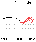
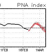
Yeah...I was just looking over indexes ... Usually, the 'recorvery' events are on the front slope of the PNA jolts... and this certainly is taking place in this reeeasonably well concerted CPC coverage: