

Typhoon Tip
-
Posts
43,454 -
Joined
-
Last visited
Content Type
Profiles
Blogs
Forums
American Weather
Media Demo
Store
Gallery
Everything posted by Typhoon Tip
-
Actually that was poorly written on my part - I didn't mean to question ORH's number and reset it to 5th. I just meant averaging all those numbers, if to get a rough sense for a "regional departure" - sloppy integral heh I'm surprised we put modest positive nocturnal in the books overnight, this last night ... Considering synoptic layout, there's a front escaping across the NW Atlantic, and a sprawling high - albeit of modest mass - arming in behind it over our region of the continent. When one has the time of year in mind, that might lend at a glance like its a 28er overnight with ease. 39 ... which isn't warm exactly no. But it really felt and even smelled like the 2nd frost - for this neck of the woods - was imminent last evening. Yet, temps apparently rose overnight though; I'm trying to figure out why - because I clearly have a rich and rewarding life ...
-
Wasn't expecting 32 per se for last night, but I was rather surprised we did not do the 34 F type frost here this morning. Really had the feel for that going in. Looking around at the various sites tied into Wunder up my way. Most graphs indicate a stall and then a rising temperature commenced around 1am. It's hard to determine what the impetus was for that behavior.
-
Yeah... Boston seems outlying. That's an interesting ORH there at 9th - almost seems outlying too - hm.. I don't know, the mean is 4.75 ..so call it 5th in the spread. I'm thinking we average to decimals under for the next 4 days but it's getting harder to ignore that warmup look/ ..faux Indian Summer - seems to be growing in prominence in the operational. We may see some of the above correct higher in rank, ...before the last 10 days of the month destroy contention - LOL
-
The condensed sentence for all that rhetoric is that these oddities could be signs of climate change ( could be - not certainty ), but society seems too distracted by perception of other urgency to take much of any notice of them. ... I will anecdotally add: ... My sister moved to Virginia Beach in 1995. They bought nice ranch in a neighborhood off Rt 58 as it cuts through toward the Beach/vacation alley ... but that's not important. She's in a partially wooded neighborhood, about like you'd see out in Sudbury or West Boyleston, with a combination of Oaks, Maples but also a smattering of borderline cold tolerant species that don't grow this far N mixed in. There are hybridized palms down at shore points. I've been there for several autumn visits over the years, mainly in November. What we have now reminds me exactly of what it's usually like rollin' into town on that Monday or Tuesday before Turkey Day that week. Wind blows, and brown broad oak leafs drift by, while neighbors are raking and putting leaf in municiple plastic leaf garbage bags - like wtf is that, anyway. Leafs in bags? They have a special truck that comes and picks up them up, too - The even longer of the former rhetoric was going to be that we, this year, look almost identical to what my other sister describes about the state of nature down where she lives, in southern NJ. She said our foliage looks exactly like there, right now - we happened to be discussing the 'lateness' of the leaf fall Saturday at relative's shindig
-
Do you know what the other's are ranked - just curious ?
-
Mine's slowed ... but the green quality of the lawn overall is not anything like is typical for this time of year - anecdotally per my own experience having lived proximal to the 40th parallel between Militia-gan and Massivetwoshits. It looks like Italian low call dressing with a side of pita bread quality out there. I don't know if that is warmth preceding, or wet, or some of both - probably both. You didn't ask me but I think we need a couple three back to back to back nights of 26 and highs staying in the 40s with cold strata splashing ample shade during afternoons, and that'll really shut shit down. Basically, a rarefied lower than normal 4 days ... without having it be because it is merely raining. I mean, really actually f'ing knuckles chilly.
-
OH, sorry bro - deleted -
-
If this were a Sci Fi arc for a climate dystopian novel, this last three ... five years of aberrant foliage coloration behavior could have been a canary in the proverbial coal mine, perhaps a foreshadow in an early chapter. The discussion kept brief, a metaphor in its self for a readership, too readily enraptured by a world overshadowed by predatory birds and thus impatient. How can anyone be bothered with any presumed, mere curious observational oddities - like smeared color seasons. Means nothing, right? - if there is any bandwidth to see them at all. We've all experienced these weirdness of autumn's over the last decade in particular, though; those of us ... you know, 'dialed in'. Something's just seemed off, year to year, with the trees. And if those were but subtle chirps, this year is more like the screech. Meandering muse: We all know how time and life, as the adage goes, go by in the blink of an eye. Our ability bear awareness of either time, or the integration of it called life, slip through our grasps, almost in tandem with our of weakening grips as we get ever older, too ( personally ...I think that is a remarkable adaptation by evolution, because as sentience became so acute in our species, the needful ability to let go of a piece of shit life would become absolutely necessary, in order to ensure lives still live long enough to be wiser elders of tribes..etc) But this last 20 years? ...particularly 10, transcends even that normalcy. It has become extreme, because the world has become such a vastly different distractive force. One wonders if it really transcends what it was like for our parents, or our parent's parent's. For throughout the gestation of their lives, they were not so immersed in a mise en science of intersecting urgencies as though caught up in a Borne Trilogy fight scene happening all the damn time, like we are now - metaphorically speaking... They never had time stolen from them, quite like we do. Don't wanna get into a generational penis length dispute over the nobility of triumph - you didn't have the Internet bringing the aromatic odor of humanity's skid marked laundry upon you face so fast that you cannot even process the smells. You didn't. Stop. And while the din of all carries on ... the last 20 years of silent signals repeatedly began to chirp, only audible to those dialed-in to change. Maybe it was that particular tree over there; it always changed at the same time, the color scheme flushing over in the same way, dependable.. "Wasn't it earlier last year?" We don't tend to write down dates of peaks - few really do that; certainly not since 2020! But then there's the colorization, too. "Huh. I don't remember that being yellow -that weird. Hm" Not a moment too soon, forgotten. Maybe the next year, it came back, but was duller, while the entire glade that's down the street, it's late and altered. Presently, trees and foliage et al linger into November, some nearly 70 .. 80% or 90% in leaf. Unhealthy leaf. Some are fall without having changed color very much all, falling in an amalgam of brown and ailing green - that is definitely different to prior years. Basically, the established multi-generational experiences in timing and color distributions, began to vary ... at first insidiously years ago, now suddenly this year so coherently? Is it a sign that a threshold was being crossed?
-
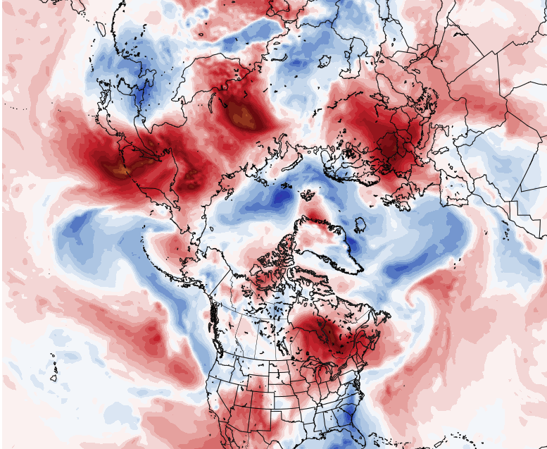
Speaking of the Euro... D10 from 00z c/o Pivotal Weather It's a little interesting ( if not unsettling ) when the 850 mb, stereographic layout of the northern Hemisphere is this off-balanced/biased. There is no question that the weight or the warm tones, is more so than the cool tones. And, it seems evenly distributed, too... It's not like all the warmth is on one side, the cooler regions...the other.
-
that's riiight. The model is that old - 1979 ... other words, always -
-
RIP Jerry Remy
-
not shocked - personally... Obviously the comparison between the two guidance types is your point - true...but beyond that, the Euro has tended to over curve the flow D5+ ... probably if thinking back fairly and objectively, it is a bias that really began that one critical upgrade that took place on August 1, 1979
-
Man ..that is impressive. KFIT is +19 on the low for today -so far. We may 'bootleg' that lower prior to midnight. Not abundantly obvious by how much that saves the absurdity of +19 ... The high is so far 64, ...this time of year, with billowing dark bases under the earlier zenith, that's probably about it. So figure +10 for high. Just looking at the NAM grid ..those numerical values don't lend to much cool advection to offset prior to midnight. We may still make 47 say ...but we'd still be talking about a +14 type of total diurnal departure - maybe. wow
-
The stratosphere draw-upon is faux science, too - He either doesn't really understand how that total mechanical/circulation system works, or... does and doesn't care because he knows his audience is in a different universe as far as any ability to take in what he writes through adequate filter of critical objectivity. Either way, .. irresponsible. The stratospheric warming correlation to the hemisphere is circuited through the mode of the Arctic Domain. There is vague, at best ... correlation between any mere erstwhile static or onset warm upper stratosphere, within the AO domain, and subsequent forcing the mode negative. Crucially, ...the science is about downwelling/propagating mass anomalies. That ring of warmth there? That's not it -
-
maybe -
-
Occasional Thoughts on Climate Change
Typhoon Tip replied to donsutherland1's topic in Climate Change
"We have outgrown our usefulness," is a capture -all, perhaps. Then perhaps a more discrete drill-down, ... maybe 'outgrown our ability to compensate for the 'drag effect' '. For/when considering climate change/denial to response-arc's 'momentum crisis' more specifically, that might be more succinct. You know? - that metaphor, where if humanity's climate-change acceptance to redress capacity is like a fully loaded oil-tanker, needing 1.2 miles to turn around ( lest sail off the edge of the world, LOL ), while we only have half that distance before crucial thresholds are breached...etc.. Ironically, I just encountered the following URL ..> article this very morning! weird how that happens sometimes. https://getpocket.com/explore/item/the-five-universal-laws-of-human-stupidity?utm_source=pocket-newtab. It directly relates to the mechanics of the "too slow" factor - how/why there is a momentum crisis. It all really starts there, in humanity's dirt. It grows like a poisonous thorny vine and strangles the forests... eventually. But implicitly, it is understood as a point, even though the article is explicitly not having anything to do with how fVcking moron-weight slows CC response - Again again again ... also a cog in the catch-22 machinery as it relates that Fermian explanation idea ... not just climate-change response slowness. It's also instrumental in pandemic spread proficiency, ...or why anything that's ever absurd is believed, and also can be ferreted out in the vicissitudes culminating in any tragic losses - usually, outside of 'bolt of lightning events'. It's really just an irresistible buffet of connection points, leading one to wonder ... how in the fVck saving this planet can really be tenable, when "bandit" or pure stupidity applies to the majority of a planet-fVcking 7.5 billion intents and purposes?! It can't ... Logically, it just seems foregone that at a minimum measure, that 7.5 billion has to go down ... way down! And the same limiting factors, then failing group-integrals, means that drop will happen [ most likely ] by way of ... 'rage against the dying of oil-lit lights' - use the imagination There are deeper reflections on the article's/Cipolla's posits for a different discussion - but in principle is apropos/factoring ( hugely really ..) in the CC crisis' complete manifold. Btw, sorry you're having to "re-read" - I can assure you ... it is not my intention to actually cause pain in a reader's head. -
Wow... that seemed to fall apart overnight - interesting
-
Thing is … 1986 had two Novie events? I’m certain the storm I’m thinking of was the first snow of the season that year. That kinda matches the ‘87 - either way it sneaks its way into my personal top 10 among more obvious ones.
-
Oh shit! maybe it was '87 ...yeah... May be talking about the same one - I always fug up dates. Anyway, woke up at 3 am to thunder ...thinking the watch posted at 4 pm ( short window warning event ) must of bust. But, it was lightning and thunder and I was a nerd, so I got up and looked out the wind and wild tree sways in low visibility under butterscotch glowing skies ...just then, 'nother vim vim BOOOM... I was stunned. I mean, I had only heard thunder in one case in Michigan from a grapply snow squall LE day, which was more CB meso. But that night... it was my first synoptic lightning snow, in 3" per hour .. going sideways. We didn't get lightning even in the Cleveland Superbomb so.. Tell ya, since moving to New England, I think I’ve hear thunder in snow storms in any winter that has actual snow storms. Back whence I was still just on my 3rd year in the area and it was new to me, though. So, there I was a 3:45 in the morning down the street through the woods standing in a parking lot under a street lamp - ended up with close to a foot, much of which fell in 4 hours .. By dawn, it was light snow and done.
-
1986 had a fantastic fast moving thunder bomb ... on the 11th lol... Just missed! ... least I'd have to check - maybe it was the 13th or 9th ...but I wanna say an odd number
-
Considering there's a dreaded v-notch? nothing -
-
Almost get the sense looking at that, a couple few members must be emphasizing the 6th wave more so than the 8th-10th
-
That Euro solution might stall but ... you know I realize we're done with autumn's perennial boredom prison sentence and would like to move things along, the obvious applies here -
-
This ... I spoke about that aspect earlier yeah. It's like the NAO D. Straight variant eitehr retrogrades to west-central Canada, or...just decays in lieu of the latter - Either way, that is a subsume scenario as is in that lala range. But your general point is the bigger take away - in general, active stormy look may be setting up - and this time, actual cold/baroclinic physics to work with, most likely
-
Man ... purely for the entertainment of the thing, the value therein is priceless if one could see the next three days of where the GGEM solution was going with that mo'fugga.. ho man! Beyond the kingdom of Bun. That D8-9-10 --> leading is like that Jodie Foster "Contact" scene, " ... No words. only poetry "


