

Typhoon Tip
-
Posts
43,447 -
Joined
-
Last visited
Content Type
Profiles
Blogs
Forums
American Weather
Media Demo
Store
Gallery
Everything posted by Typhoon Tip
-
March 2022 Obs/Disc: In Like a Lamb, Out Like a Butterfly
Typhoon Tip replied to 40/70 Benchmark's topic in New England
I can see that... We got regional LI's down -2 tomorrow. -
March 2022 Obs/Disc: In Like a Lamb, Out Like a Butterfly
Typhoon Tip replied to 40/70 Benchmark's topic in New England
Exactly! ...only like 20 F down the scale but it's really quite analogous to that. yes - -
March 2022 Obs/Disc: In Like a Lamb, Out Like a Butterfly
Typhoon Tip replied to 40/70 Benchmark's topic in New England
That's actually a recovery of the PNA there... Remember yesterday(this morning ) discussing how the EPO didn't look like it would relay as well, but that is actually quite a bit better than the last 2 days prior - that "might" be enough to signal there. It does time for a 06z/12z GFS blend ...about 168 -190 hrs. Just sayn' but ...there's also been a remarkably persistent tendency have the next run go out of it's way to seemingly constructively interfere with one's optimism.. .LOL... so there's that too -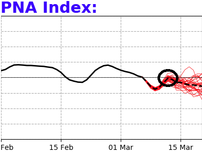
-
March 2022 Obs/Disc: In Like a Lamb, Out Like a Butterfly
Typhoon Tip replied to 40/70 Benchmark's topic in New England
It's real... I'm singularly impressed with how abrupt this warm frontal intrusion has either thrust into the region... or just abruptly mixed out. Probably some of both. It was 36 at 7am here. You know, I was looking at the hi res vis loop, ...pissed off and disgruntled at the delay of warm arrival this morning... Yet, you could see that granular texture in the cleared areas of eastern NY... Crispy edges to cloud debris is very summer like. In fact, when the fog lifted here actually about 2.5 hours ago, it revealed a sky that looked like a May tapestry under alto level elevated ceilings. But it was still just 44 F at the time though. A splash of sun came through about 11...and it was 51 very fast. The air started to smell like summer b.o. a little... 62 with mostly sun right now. sorry - It's just I think these sudden seasonal exit-entrance scenarios in the spring are fascinating. I mean, I've seen it go from 91 to 40 in 2 hours fro BDs.... I've seen it go from 36 to 66 in a warm frontal instrusion like today. -
March 2022 Obs/Disc: In Like a Lamb, Out Like a Butterfly
Typhoon Tip replied to 40/70 Benchmark's topic in New England
If we can get the NAM's RH at 700 mb to dry out a tad, tomorrow could be just as sweet. Buuuut...not to deb down it but it will make Tuesday that much more annoying lol. Ah well ... -
March 2022 Obs/Disc: In Like a Lamb, Out Like a Butterfly
Typhoon Tip replied to 40/70 Benchmark's topic in New England
Yup ...good call. 61 and mostly sun here out of no where. Like walked through a door into a Narnia world compared to 2 hours ago. 36 at dawn here, with murk and fog. 61 and sun and probably heading for 65 ( classic MOS bust) ... So despite my warm bust' post a while ago, it appears warm front was more delayed .. It's funny how this happens though sometimes. The warm front comes through, and it goes from a delay/busty, to correcting actually warmer than guidance. interesitng -
March 2022 Obs/Disc: In Like a Lamb, Out Like a Butterfly
Typhoon Tip replied to 40/70 Benchmark's topic in New England
It's really hard to ignore the vast deconstruction of the EPO handling that's insidiously claimed the otherwise favorable look we had been erstwhile tracking. It seems to erode ... slowly, under the radar, spanning five days ... Now, both the EPS and GEFs ( centered on day 10 ) have a dying EPO ridge receding back toward Kamchatka... with a zonal, velocity rich flow, spanning the entire hemisphere from west of the Dateline to NS. ( ssh...sometimes zonal flows precede subtropical ridge expansion. That's synoptic 101) The previous "optimism" was based upon the climate behavior of -EPO's tending to fade into +PNA's... That would be a segue into a storm potential..etc.. EPS loads cold... PNA sends amplitude underneath. Boom. But this has suffered ( maybe?? ) seasonal wave length - seems a bit early to make that assumption. But this is situation either way that will dump cold into Canada, but then an unattended -PNA circulation mode may not bring it south...nor serve any means to amplify... It just changes everything. The other aspect I'm hypothesizing is that the speed/mass balancing of the hemisphere screwed mechanically ... like it tunneled under and abandoned. Both operational Euro and GFS ( 00z ), average about 3.5 day periodicity between cold waves and warm sector oscillations. With nothing but different hobby engagement worthy events separating, through day 10. Honestly... I did post reticence to the March mid month period last week. I cited the fact that EPO signals may not carry the same telecon correlation at this time of year, as they do DJF. It's just that the PNA aspect intervened and sort distracted the look ... Either way, the EPO is not at this time, modeled to subsequently lead a +PNA of sufficient anything.. Nothing's happened yet. We're still going to have plenty of late season cold loaded nearby over Canada. And the 06z GFS ...which I'm tossing pending anything from anyone or source that concurs..., shows if nothing else, 'how' it can happen in a butt bang pattern. -
March 2022 Obs/Disc: In Like a Lamb, Out Like a Butterfly
Typhoon Tip replied to 40/70 Benchmark's topic in New England
There is a mid and U/A clearing punching in from the WSW though... Roughly SYR-PIT at dawn and it's leading edge is already knocking on the door of ALB. I wondering, when it unlids eastward if it just exposes this static cling on the bottom, or if it arrives with a t-spike and some breeze. -
March 2022 Obs/Disc: In Like a Lamb, Out Like a Butterfly
Typhoon Tip replied to 40/70 Benchmark's topic in New England
Warm sector bust going on today though ... I haven't been paying much attention to the details, admittedly, but the general synoptics offered by most guidance I've seen ...didn't appeal like we'd be stuck with the "spilled latex on the highway" look on hi res satellite. Sometimes ( hypothesis ...) I've noticed this about/when in these high velocity flow scenarios, where the warm advection takes place, but seems to perhaps be 'too fast' - it out paces the Eikman (ch spl) drag effect? That cold lower saturated fog miasma, needs some special scouring the sun is just slightly too weak to do on it's own, yet the sounding is protecting the surface. It's almost like a stain on satellite. Whatever it is the strands this paste in the lowest 50 mb of the atmosphere ..it doesn't help that we're drilling mid level cloud swaths over top, either. -
Gas doesn't have a very good shelf life. The volatile BTEX compounds the make up gas are weakly bonded - one of the reasons why it is so useful in combustion. Combustion is just a sped up oxidation process where H --> is added the reaction ... gas + H + 02 --> C02 and H2O, and any impurities ..etc... blah blah. But the weak bonds mean it will tend to separate, on its own, without heat. Anyway, one would have to be careful and rather technical in how gasoline is stored for it loses its potency. 55 gallons filling a drum is a lot of a mass, and by virtue of weight and density, it would have a longer "half life" .. The storage facility would have to be properly engineered and subsequently maintained, or eventually .. you may end up with 55 gallon drums of a carcinogenic sludge
-
The oligarchs will have covert ops involved at some point. Bank on it -
-
March 2022 Obs/Disc: In Like a Lamb, Out Like a Butterfly
Typhoon Tip replied to 40/70 Benchmark's topic in New England
Yeah ... this is basically agreeing with my coverage. Losing that PNA relay is frustrating. Was really good before. It could return. Obviously you know this but signals can 'pulse' as they approach in the guidance. It's just hard to know if that is the case in March - I still think there could be a system at the other side of the EPO ... I mean, there will be cold near by and the flow may relax - that's more of a bowling frame-up probability so tfwiw. -
March 2022 Obs/Disc: In Like a Lamb, Out Like a Butterfly
Typhoon Tip replied to 40/70 Benchmark's topic in New England
I don't know about the mid month aspect anymore.. Not feelin' it on this one. The indicators are dubious at best, and the -EPO may not be enough to do it alone at this time of year. We need the -EPO to relay/lag into a +PNA rise, and there is one but it is not very large... That doesn't send the best signal down stream... Plus, when we are soaking 40 N with near equinox sun now, radiative forcing modulates more and more. I'm seeing the models correcting some of the cold air mass cores a little already.. So you know we've had blizzards through April and we may very well... I'm not talking about bowling season and/or catching a break on a lucky stream sync. Those are separate means for getting it done. I'm speaking mainly to the "orderly H.A." idea. The GEFs ensemble mean has two roll-out warm-ups if anything, between the 13th and the 20th, and this matches reasonably well with the operational version. The whole American model system wants an oscillatory pattern in a progressive/longitudinal flow type. There are a minority of members that have more commitment to something on the EC... They are mangled Miller Bs or smeared Miller As. Arriving from different means that appear to be more typical long lead noise. My previous optimism was based upon the +PNA emerging as the -EPO block subside ...not an atypical relay. But the latter doesn't appear to be emerging robust enough to force the correction event. I remember one year it stayed usually cold in Canad almost to the middle of April. What year was that? End up with NP floods when it warmed finally in May. But not much cold anomaly really came south of the Dakotas that year.. You know, it's possible we load Canada with -EPO dump and don't get much going S of the 45 L other than what the GEFs is showing.. -
March 2022 Obs/Disc: In Like a Lamb, Out Like a Butterfly
Typhoon Tip replied to 40/70 Benchmark's topic in New England
Ugh...seeing everything through a neg-head lens. I hate the pal sun under milk sky days in the 30s with corn snow on the ground you get at this time of year. It just is too uninspired, nor comfortable. I don't think this warm up Tomorrow and Monday is all that great either, not if leaning against 30 to 40 mph wind gusts ... Even if it's 60 that's going to be A-nnoying. One little interesting aspect, the LI drops to -2 regionally on Monday. -
Pure anthropology. Human species greatest natural instinct is the tendency, if not dependency, to social hierarchical command structures. What you’re observing … throughout history, are masses unwittingly compelled, gravitating toward that paradigm - perhaps like moth to a flame. Outmoded instinct it may be, for it now clashes with a reality that despots in alpha roles are vastly more than merely assholes. They've become death, destroyers of worlds.
-
https://www.cnn.com/videos/business/2022/03/04/mikhail-khodorkovsky-putin-intv-dos-santos-ovn-intl-ldn-vpx.cnn/video/playlists/russia-ukraine-military-conflict/ ...anyway... I maintain my original take on this whole thing. We're not dealing with a "foreign sovereign agency of war times" type of adversary. You're dealing with a unknown vector... a mad-man that is enabled by group psychosis ( think 'Third Reich'), who/that is/are decided/ing, in disconnect, what is going to be righteous. He/they possessing enough arsenal to complete the present extinction level event. they have decided they are not going to lose this thing This needs a artful ...implying among other techniques, covert ops solution.
-
March 2022 Obs/Disc: In Like a Lamb, Out Like a Butterfly
Typhoon Tip replied to 40/70 Benchmark's topic in New England
... it always is with that f'n model. -
March 2022 Obs/Disc: In Like a Lamb, Out Like a Butterfly
Typhoon Tip replied to 40/70 Benchmark's topic in New England
Yeah wrote about this an hour ago ...not that run, per se, but the fact that the GFS is smearing/interfering a D7-ish Miller A with what appears to be a half-assed attempt at a -EPO Lake cutter. I think the GFS is suffering from a speed bias ...one that it has at all times, but by virtue of operating in a speeding field...it hides that propensity - it's little complex. It's like the fast gradient soaked hemisphere "enables" the GFS ... anyway, I think the GFS is too fast. Conversely, the GGEM tend to curve surfaces too much in that range... so to does the Euro. They both seem to get to that subtle bias, different ways though... (different discussion). But the take away is that a decimal-slower look would keep these features into their own identities, so we end up with a glob Miller A of minoring impact in the Euro and GGEM... with the GFS just one big exploited ravioli... The GGEM has a much more H.A. correction event look, after any would-be Miller A. That's essentially the Ides bomb I mused yesterday, really. The Euro opts for a just a big intense polar front with unending cold implied, with not much else resulting from these index wiggles... Meanwhile, the GFS' dailies seem to hearken seasonal change ... It's not "sustaining" warmth - I agree there. But it is bulging more hydrostatic thickness and then residually leaving them at higher latitudes post fronts out through 360 hours. It's an aspect it started doing yesterday and still is...It "might" be seasonal stressing/radiative forcing ...who knows. -
March 2022 Obs/Disc: In Like a Lamb, Out Like a Butterfly
Typhoon Tip replied to 40/70 Benchmark's topic in New England
Depends on one sub(sub-forum) ~ day 4.5 there is a minor impact potential for mainly central New England. It's another needle thread system - what's new over the past 10 years.. So where it snows, it will be narrow latitude. The Euro is farthest N, the GGEM is sorta between, the GFS is S enough to bring blue snow type all the way to the Pike. But neither of these solutions would implicated NYC area with any snow. Of course, ...that is as of 00z suite of runs, and there is 4.5 days it's possible they are all wrong. ~ day 7, a Miller A of weak to moderate scope moves up the EC. That system is more coherent in the GEFs ensemble mean than the operational version, which seems to be smearing it together with an -EPO Lakes cutter a day and half later, which heralds in the much ballyhooed mid month cold. The Euro and GGEM depict more separation between those, with more individual distinction. That allows their version of a weak to moderate Miller A to swath chilly spring rains up the EC, ...where eventually it runs into isothermal soundings (+) or (-) 1 either side of 0C at 850 -925 mb ...Strictly adhering, it's mixy and cat paws for SNE with snow N, but at this range in the spring, blue events always look like cat paws. Which at this time of year that signals the blue snow scenario ( < 10::1 cake). It'll take a couple days -worth of runs to radar which modeling has the better idea. I can see biased reasons for both to be wrong. -
March 2022 Obs/Disc: In Like a Lamb, Out Like a Butterfly
Typhoon Tip replied to 40/70 Benchmark's topic in New England
mm... the 18z run is clearly being exerted by seasonal change there. The run is having difficulty sustaining a cold look, despite the -EPO/.. loading in the D6-12 range. There are three cold inserts that are brief ( < 36 hours), that roll-out synoptically, replaced with warm bulges to almost 40 N. Not sure it's right - in fact, any 18z GFS run on an island is low confidence to put it nicely... However ... recent springs over the last 10 years tell you not to doubt a warm bulge just the same. And, at some point we will seasonally flash over the hemisphere with dullard the gradients. I thought that would be on the other side of the EPO...? This run seems to just be an oscillatory look - event reduces the need for a correction event at the Ides. -
March 2022 Obs/Disc: In Like a Lamb, Out Like a Butterfly
Typhoon Tip replied to 40/70 Benchmark's topic in New England
really ... it's been a problem all season. The entire dial of the hemisphere's been slipping back into that base-state where the ridge in western N/A is really more lapsing into the east Pacific ...sort of a west-based +PNA, or east-based -PNA, which ever way one chooses to identify it. But it's stressed systems ejected E, during the "perceived +PNA" episode, because the flow is caused to split coming down the Rockies, with some mechanics meandering through the SW - not being entirely sure it will reunite with the more N branch as it tunnels east through the Lakes. The blizzard mid season was about as close to reconnection/phase as we've gotten. Usually... there's been more destructive interference however. -
March 2022 Obs/Disc: In Like a Lamb, Out Like a Butterfly
Typhoon Tip replied to 40/70 Benchmark's topic in New England
Little critter that bites? although that looks a little more than innocuous on satellite - ..actually, it looks like it's in a RI -
We've written some long prose with creative turn of phrases regarding the paradox of human evolution - over in the climate forum.Yup, I hear ya. I mean we both know there have been scholarly studies, to dystopian novels written, for decades. Folks should get into Fermi's Paradox ... and the hypothesis' that explain. The paradox was a destiny prescribed by Nature, its self. Look around us everywhere, in biology. Nothing that exists, that is alive, does so with no purpose. Nature does not waste time moving organized energy ... directly to entropy. You don't have a 3rd eye, for a reason...etc, but one eye fails depth perception. Two is just right ... oth intra process in the organism, its self, and how/service necessarily give in the integrated ecosystems of the larger biosphere. Therein is the problem... evolution provided our survival advantage being cooperation with higher intellect and ingenuity. Our survival has become hyper efficiently successful. 8 billion evinces that truism. Which by that "natural law of necessity" ( above), means that what got us here, ... effectively canceling out what got us here.
-
March 2022 Obs/Disc: In Like a Lamb, Out Like a Butterfly
Typhoon Tip replied to 40/70 Benchmark's topic in New England
I suspect we're seeing the early formulation of an Ides bomb my self... - give or take a day or two. -
March 2022 Obs/Disc: In Like a Lamb, Out Like a Butterfly
Typhoon Tip replied to 40/70 Benchmark's topic in New England
Been speaking to the relay of the -EPO --> +PNA mode switch my self. Its being prevalent in the 00z is 3 .. 4 days of consistency there. It may be the last hurrah of the winter, for a larger synoptic/systemically rooted correction event ... Still looks like the "modeled intents" - for lack of better words - of the greater circulation prognostic heading out two weeks.. .etc. Doesn't mean it's completely over ... Winter storm enthusiasts start looking for 'bowling balls' This phase "spring puberty acne" happens when the hemispheric gradients tend to abruptly relax ( relatively ...), effectively stranding what's in the flow at those times. It's really more like a range of time where that type of stranding risk is elevated - 2 weeks or so perhaps. It's early ...but so far, the best candidate so far is the bigger dawg event that's in both EPS/GEFS and GEPs... around D10. It is unfortunately behaving ( for the time being ...), more like an EPO cutter. Which is interesting, because ... the EPO is rising at that time, after the negative sequencing. EPO cutters typically take place as, or nearing ...max -EPO on the front side of the gestation - whereby the flow downstream troughs over the Great Basin, and the wave transmittance orients the flow up the EC ..etc. There is caveat to this model, however... The flow in the eastern Pac can sometimes tunnel completely under the EPO ...cutting it off.. That does change the map a little for what/how things evolve over the mid latitude continent ... So something about that 240 morass is a little off. The flow is fast, and with that cold height loading into Canada, it's going to be really hauling ass. I would not be surprised if the R-wave total lenghts end up stretched a bit longer than climo with that whole ordeal. I think something being in that window is high confidence. What that is ...? I would not trust that giant busted ravioli mess ... The period of time in question has an H.A. correction look to it, either way.
