

Typhoon Tip
-
Posts
44,217 -
Joined
-
Last visited
Content Type
Profiles
Blogs
Forums
American Weather
Media Demo
Store
Gallery
Everything posted by Typhoon Tip
-
I knew last Sunday and Monday ...during that rare utopia weather landing cookie-cutter perfect on the Holiday necessity and mirth, we were going to pay a persecution tax for it by spending at least as much time the other way, and then some. However, there's a hidden incentive in the notion that it landed Tue-Thur morning ( so far on the latter), because unless one's retired or working from home, or just has the luxury of every day being "Sunday" - it's more important that relay into crudsville happened in this order.
-
as for SNE proper, I can see plenty of Earth through that. It's not that pervasive and dense. I'm thinking more like it it gets better for an hour, then pancake maybe ? But that would be after the fact. Clearing's about 15 mi W of me ...I guess I'll see soon enough.
-
Heh ...snark aside, this is actually an outstanding insight. That's not atypically how these things go. But, the difference here is that there is really nothing above ~ 900 mb after this lid pulls off, and it will expose that gossamer lower veil of strata to the intensity of the June sun. So if there's an exposing 'undercast' it's likely going to offer about the same resistance as Golden State did in that 4th Quarter annihilation last night. Also, as I intimated earlier... even though WPC doesn't analyze a frontal extension along the back edge, my personal hunch is that one is vestigial and by decimals of advection is enough to assist clearing.
-
https://weather.cod.edu/satrad/?parms=local-Rhode_Island-02-24-1-100-1&checked=map&colorbar=undefined
-
Thankfully ...there's a definitive clearing entering western MA/CT, inching east at the speed of 15 mph plus erosion rates. WPC stopped analyzing a front extending N from NE PA into NNE but the look on sat loops seems there's still a vestigial echo of that physical exertion helping to delineate why SNE is an anal hole climate compared to the everywhere else in the U.S.
-
I think I'm satisfied with opaque skies casting a dreary daylight over a pall of still, cool dank. This can go ahead and move along now...
-
Why not? it'd fit the notion of receding frost lines do to CC - ...we're not going the other way. Dearth years should become more common. I suppose a couple a of good winter are easily still within reach ... I mean it's all "supposed" to take 50 years to get DCA's climate to PWM or whatever. At some point, we'll get around to a MR Blutarsky winter out at Logan.
-
IF anything ... this, https://getpocket.com/explore/item/an-ancient-era-of-global-warming-could-hint-at-our-scorching-future My own op-ed: Simple conceptual question to mull over: It took the Earth a billion years to create and stow all these volatility in the form of fossil fuels; humanity comes along and threatens to release all that reactive chemistry ... back into the dynamic system in just 500 years ... and yes, time is a variable that matters! What the f do you think is going to happen? Nothing?? The PETM -like acceleration debate has been going on for years. It isn't new, no. But, we're already seeing sudden sea floor methane releases ... These are evidences. Siberian blow-out phenomenon, we're- most likely - heading in a direction of Methane inclusion in this whole mess...turning an already non-linear rise in global temperatures, into something that is accelerating too fast for most systems of nature on the planet to adapt. It is not frankly clear with climate prediction modeling whether they are factoring in that 'wild card'.
-
Lol ... actually it's toward the end of October but point taken - The only problem is, I could not be more check out on winter. I suppose if I was locked away in an insular work effort pouring over climate regressions for seasonal forecasting in some back office trying to meet a deadline, I wouldn't be very much in a summer mode or even interested in that setting. Barring that kind of job opportunity ever landing in my lap, I'm gonna go ahead and not give a ratz azz about anything resemble blue on a weather chart until mid November.. And it's not even a conscious choice - it seems to be connected to celestial mechanics ( i.e., the actual orbit of the Earth around the sun) for me
-
It's funny ...between Ray's 55 and Brian's 51 and my 54 ... We still are not "sustaining" warmth - Recall the other end of May ..end April time span. The postal tenor ( as in nearly ready to "go postal" lol - ) was angsy around the notion that we couldn't put back to back to back warm, much less milder days together, before getting the rug pulled out and slipping back into a pattern that uncannily felt like cold shit while still managing to be +.5 above normal... That's still happening. We've seen two failed heat waves at least put one 90 in away, but otherwise, 80 ...but we were never far from this kind of "putrocity" we see out there right now. It's more of a personal druthers or subjective take, granted - but I'd like a 7 days of above 76 F, with maintenance convection to keep the Stein nimrodery down to a dull roar.
-
As a low grade concern, yet a smidge higher than base-line climate ( qualified enough ha), we do have a flick our eyes to the side occasionally over the next several days, just to be sure.. Hurricane Agnes was forced through the Central American wall but it's remnants are being reactivated by the Euro. The other models are doing so too...just not with this same proficiency we see below: So long as that westerly limb -NAO is in place ( per the post above, D5). It is not impossible that this TC phoenix might be forces closer along the EC.
-
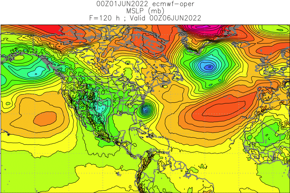
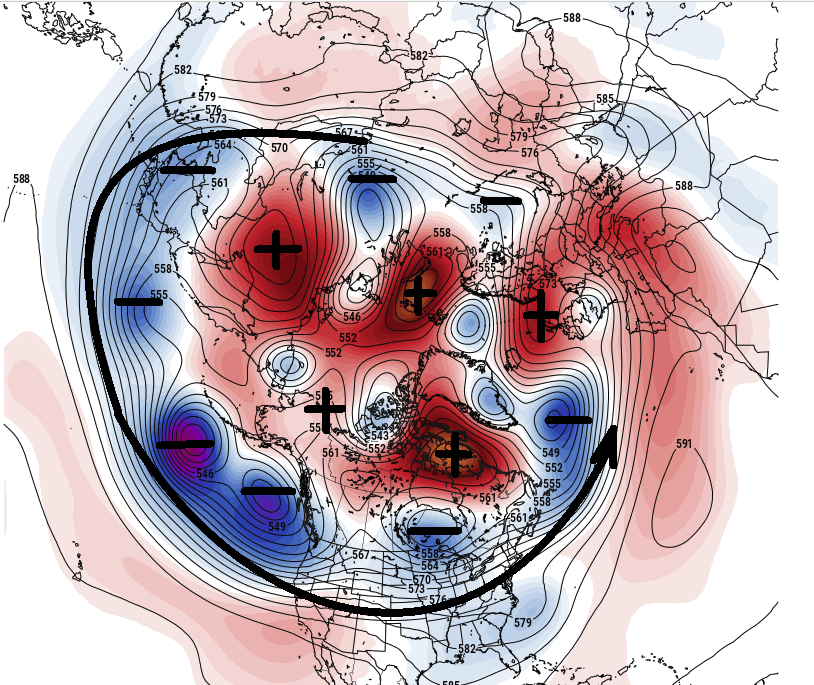
The cause is different than spring, though. Not that anyone cares what the whip looks like. Make it stop - right? This is an unusual phenomenon that needs its own space/attention: excessive -AO It's not as traditional looking as that which we may observe amid the winter months, however - it's actually quite bizarre. Large vertical height anomaly nodes in the 60/...70 latitude, that have less horizontal dimensions. If we average out the polar domain of this annotation below, it numerically produces a fantastic -AO total, ...but we don't see the R-wave scaffolding of mid winter -AOs. Stab at hypothesis ... this is -AO mapped over a radiatively forced/seasonal warming. Doesn't explain how or why these intense vertical foci of heights are there ... The -AO result may in fact be less wave-mechanically a negative AO, and more just a numerical emergence of another systemic phenomenon. I guess it doesn't matter for the summer-lorn among us... stop the whipping! But, the mid latitudes are not getting summer so long as this below set up... And it's capped the entire world's N. Hemisphere, so overwhelming it's really effecting the pattern underneath at mid latitudes, everywhere... (120 hour EPS mean; 00z June 1 c/o Pivotalweather) The negative anomalies that garland the planet along mid latitudes is what drives the cooler appeal. This total compression causes this westerly/ambient velocities to be way, ..way stronger than normal for this time of year... while the total compression N-->S, suppresses hugely south ( that circumpolar continuous arrow) of climate. I mean this is so bad, I almost want it to just go true climate event and do something super extraordinary. But alas...we likely won't get to see that science awe moment; it'll only gobble 2 week of the summer. This isn't the same as a cut of west Atlantic low... or ensemble-line BDs typical of NE ...while west of Albany basks in Pandorian utopia spring curse... This is some kind of whack planetary problem in scope and scale. It's noteworthy for me.
-
Multi pulsing CG show from cell passing SW over the last 20 minutes. Small but intensely electrical cells
-
Small but intense cells popped up west and southwest of Boston
-
I can hear distant low decibel hums coming over the horizon from those cells all the way up here in the Ayer Also a field of dark bases with some vertical growth over top just expanded over the sky pretty much all quadrants where I am. I’m wondering if some overrun convection is initiating as the heat over New York tries to lop back over the boundary
-
I don't disagree with much of this ... My point is simply that we should strive to be better, as a people and society, then that which took place last week - that's all. China can do what they do - so long as ( ha! ) they don't do it to us. Which is probably inevitable, too. The mental illness thing is interesting though. I was talking to a retired social worker, clinical psychiatrist that worked in the 1970s, in one of the last federally subsidized insane asylums in the 1970s. Near the end of that decade, those subsidies were frozen and redirected. The 1980s arrive and suddenly the sight of a person having a heated debate with telephone pole, while passer-by's turn heads trying figure 'em out, became a much more common. The change in attitude and abandoning programs, released these fringed unstable folks to the common walk. But most importantly ( according to his discussion -which makes intuitive sense) created a failing framework for future generation support systems, to where levels of angst, to deranged types and the entire spectrum of abnormalities could not readily be guarded - not just to get treatment, they now get ignored! Expose those types to the over stimulating histrionics of the Internet gaslighting manipulation machine, amid a culture that protects rights to gun ownership to the grave... Well, ends up sending masses of them to that destination. When those programs stopped in the 70s and 80s. ...those that left those offices knew this was coming. It's just a lesser known perspective that mainstream media doesn't elaborate upon because there's no profit in news that exposes us to our ancient faults.
-
I'd say overall it came in 1-2 hr delayed where I am, and about 2-4 hr delayed working SW through the area. But rest assured, all areas end up on the cold side of this thing before late night. Maybe NW Mass holds out a bit ...and west of the Greens... It looks like it's "filled" the regions east of the Monads/Wachuset ridge to at last "spill" west... It's a shallow air mass, but with potency in that shallow layer... It's sort of given the false impression that it is weak but ...it's not. It's 57 in BOS with BR haze and strata/'dead sailor's ghost', and down to 62 at BED... When the sun goes down, the strata probably fills in, out to I95 ...may 495, with valley fog elsewhere. The NAM wants that band lurking NE of the region to come SW and choke off any morning sun tomorrow, such that the murk then gets capped over - it's like it's got this agenda to torture eastern SNE like an OCD. Euro agrees though... I don't think I've ever seen a more quiescent series of weather charts, days 4 to 10, like that 6 days of Euro model. I mean nothing happens in any direct, everywhere ... Dearth of anomalies. Zero restoring events. weird -
-
Battle royal between June sun and the cold Labrador sludge. As the sun goes down, ...unless the 'appearance' of momentum slowing really does go calm, the slab gets denser and creeps inland. By dawn, it's still slate gray. But therein is the question...if the boundary does run low on momentum and the feed into the backside also wanes, that may be less ... It actually changes the outlook for tomorrow too. Because the sun would rise over a gossamer veil, and we could brighten -
-
Interesting.. I was kind of more interested in the wind - like was there a noticeable shift as a 'valley jet' kind of feature might have set up -
-
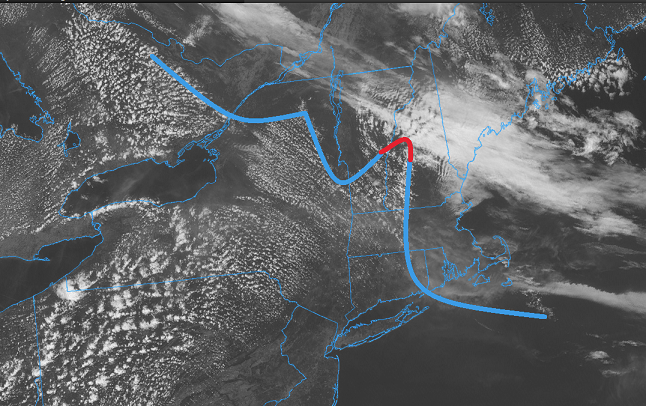
Are there any obs down the Champlain Valley ? It looks like this BD is unclean and fragmenting, possibly getting an assist/preferentially riding along lower elevations. You can see it scouring out along the St L. Seaway, moving W over SE Ontario...then there's some resistance over the Tughill... Then it's scoured out down the C -V..., then more resistance over the lower Whites/Greens... Then it's bulged west like a prom night breast over eastern SNE...
-
It does look as though it is running out of momentum, doesn't it. It's still identifiable on hi res vis loop, scouring out the fractal CU.. But it has clearly slowed/begun having trouble getting west of Monadnock-eastern CT elevation axis. I'm not sure if that's dependable the rest of the way, today. Maybe, but the models didn't really do too well with that behavior, with a mid day deceleration taking place like that, with the NAM ( for example) on previous runs showing no hesitation careening it right down into NJ, unabated. One thing I am noticing ... again ( it showed up yesterday but at the time I thought it was just 'noise' in the models), they've closed off the 1016 pressure contour over SE NH/E MA...with actually d(P)'s nearing -2mb farther up toward PWM later in the afternoon. That's telling me that that this initial pulse was not as well back-built as these guidance illustrated on prior runs. Without pressure rises contiguous up the way, the source is cut off... That said, the pressure does begin to rise again near PWM ( up in lower Maine) later this evening. That would likely require a secondary push tonight if that occurs. But these are only 2 mb variances so... 74 here ... temp actually came back 2 degrees. Winds lightened off too. It's actually deliciously pleasant right now.
-
This could have used an air quality alert statement...
-
Yeah you can just sense looking at that, it'll want to fill into the region behind the front as the day gets on ... packing in eventually. I have to say, this is probably the more vivid example of a BD phenomenon in its purest form, I've seen in many years. I may not be qualitatively exactly right about this, but it seems overwhelmingly like our BDs have been more hybridized in character ... Sort of lost in other stuff, or perhaps wimpy in general. This? wow - I mean pollen plowing pulsed gusting. It was really through here like a gust front off a thunderstorm. The delineation in wind direction and in very short order, the temperature response, was just as quick. Also - in that satellite loop abv you can see that line extends out into the ocean by a considerable number of miles. I wonder if that's a subtle marine problem for vessels/'white squall' out in the Bay waters... I mean if your in a small schooner or some prone vessel, and then it leans over from out the blue sharp wind shift/acceleration.
-
Just offering a little perspective on this. It's all a matter of perspective. At this time of your, many are anxious to get on with the new season, to feel summer's exuberance and vitality, the weather-type events that are 'supposed' to come with, and all that jazz. Which at a minimum, the expectation of heat is a part of that. But come late July, when we're pretty fed up with it ...say three or four failed heat waves from now ( 91/95/89.4), and it's become annoying and it's lost it's novelty. The lawns are beige. It'll be a 91 maintenance grind and your out there having to do something in it, ...just how much would you wish at that moment this sort of jolt cold correction would blast through. Yet at the furthering end of the spectrum, when we are damned with a fascinating icing scenario, and risk going to 32.4 and losing the nature's art work, how much as winter enthusiasts we suffer the horror of watching the cold air fail.
-
Time sensy but check out this sat loop - this is fantastic! https://weather.cod.edu/satrad/?parms=local-Rhode_Island-02-24-1-100-1&checked=map&colorbar=undefined


