

Typhoon Tip
-
Posts
43,440 -
Joined
-
Last visited
Content Type
Profiles
Blogs
Forums
American Weather
Media Demo
Store
Gallery
Everything posted by Typhoon Tip
-
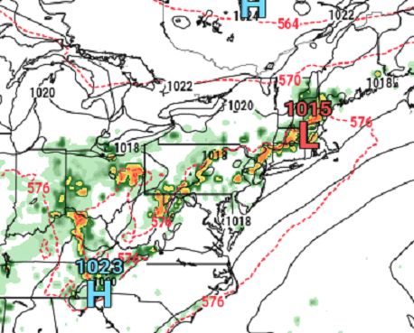
Stalled front... slow moving/light steering field aloft ... These cells are just overcoming the rising heights as the WAR ridge is retrograding W. The sun's zapping all that thete-e. Thing is...not sure how the Euro does at 114 hours with the particulars of convection/convective verification, but the orbital synopsis doesn't scream like this can't happen. That axis of convection would rain with impressive rates..
-
We could conceivably go some distance to correct seasonal hydro deficits between Friday and Saturday ...if fractals don't intervene negatively... Heh.. but that's a nasty look with that Euro's recent several cycles persistently stalling a front/frontalysis between along an ~ DAY-BOS axis. GFS is 70% or so similar but as usual, it doesn't prefer stalling features and keeps it moving SE into a 594 DM height wall which makes less sense... Pros are the immense theta-e pooling. I'm seeing the 00z Euro actually gets Friday back to 90F along the Pike, but DPs are nearing 75 at that time in the 2-m DP product as depicted over at Pivotal. Forget the HI talk for a moment, that's gotta boil up some big CAPE. If accessible, even an accidental pixel shower out of random CU would water board a down town crossing.. We don't need very obvious triggers in that environment, and the Euro is outright modeling a explosion of slow moving 3"/hr along said/implied convergence - even with the rising heights capping matters.
-
So it was already a hundred at Logan this summer... It occurred on July 24th ... heh, pretty much smack on the climatological acme. unless the number was since disqualified... I was around several locations between Clinton and Ayer that day ( Sunday), and the digital display on the dashboard was routinely 101 .. 102. Probably 96 ... 98 in reality. It's hard to trust a car's dashboard reading unless you turn off the road and drive across a grassy lea for several miles at a 20 bumpily miles per hour to clear the gauge of asphalt farts. or, maybe it was 100 at a few points along the way, just the same - hell, it's within the margin for error. So not just Boston's west wind anus out where Logan bathes in city wash.
-
As far as experiencing 100 on the skin - mixed emotions there. It's like how I want to go to Death Valley just once... Or stand out among the white sands above the Red Sea in a moment when it is 121/88. Take a few deep breaths. Gaze around at an ozone glazed sky that one's senses impels the imagination, its color hints as magenta. But, I would only do either if I had 100% assurance to escape avenues, immediately accessible.
-
I gave up on 100 three or so days ago in the ongoing speculation disco - Too many dodging idiosyncrasies starts to give that non-scientific sense that if you want to observe the novelty of ...anything really, be it cold or hot, rain or snow...wind whatever, there is a distinctly undeniable aspect where it deliberately does not happen ... LOL
-
Not sure if this is sarcasm but either way... I agree. It does this every year at this time - goes off the deep end and proffers skipping right over that pesky long slow grind of summer's end and its how about we jump right to Halloween - who's with me! The thing is, the climate starts to cool off after the first week of August anyway. So, the same way the model is overly amplified like 90% of anything it's physics is permitted to see beyond any given D7 ... it tries to do the same thing, but not with just events but the whole season once Augie roles around. It just annoys me that it can't do this the other way in April... when it holds on to winter and as soon as the D7 arrives, it looks like the chart may as well be Feb 15th. It goes along with it's over all wild cold stormy vibe it biases toward in the extended, in general.
-
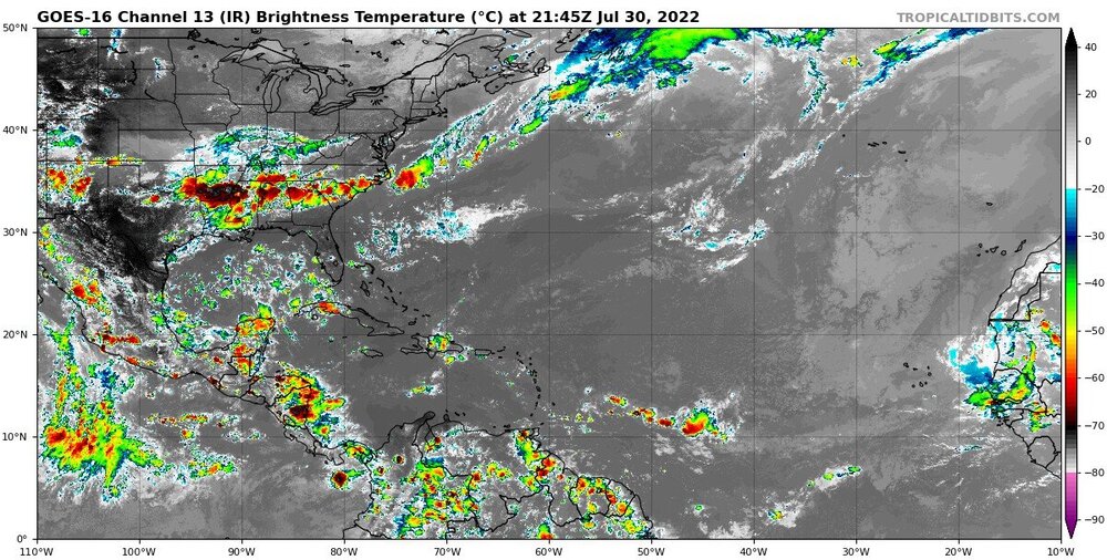
It's possibly the lack of ITCZ that's causing the +anomaly SAL - or there is some governing factor relating to both. Looping this for the last 5 days, take a look at the African side of the MDR http://tropic.ssec.wisc.edu/real-time/sal/salmain.php?&prod=split&time= The SAL has zipped shut the region. There is no cloud production at all subtantive enough to condensate and clear out at least the ITCZ. It's like the equatorial monsoonal trough it's self is weak - or stopped. weird. Not only that... I'm also noticing there is a perceivable dearth in both frequency and intensity of TW demography. There are none...
-
I dunno..it's kind of hard to tell what's happening out there. It seems we're nearing seasonal zenith in the non-hydrostats in these models - perhaps in reality. It is difficult to parse out if there are any real heat bursts embedded.. Thursday looks legit. But beyond is very dubious to me. The Euro at 00z pulls off the largest c500 mb height anomaly spatial layout out perhaps in years by this Friday and Saturday, encompassing everywhere S of 50 N ? 71 F 18z Friday. Ok - Meanwhile, the GFS thinks it's late November with the power of polar jet it Neptune's across southern Canada...so much so that it ablates the heat's ability to get N without sanding it off by phantom fronts. It was wrong about the 5 day heat wave because of that reason, and that thing happened in less ridging so there's very little confidence the GFS isn't just typically SPV happy.
-
It’s interesting that as July turns the page into what is typically a very active month for tropical genesis, we peer out across the entire breadth of the Atlantic Basin and we can only define absolutely ….nothing… Zero aspects of interest.
-
PF and I were speculating this oddly disparate layout of temps today late last night. Slightly below to above Nw to Se in the same well mixed atmosphere is unusual
-
So y’all gonna be below average by a “few” degrees. Hmm. It’ll be interesting to test that idea. I mean 1 or 2 sure. Sounds a little NNE Met love me some cool bias talk. Lol But it’s likely to be 2-4 above normal down our way. It would be interesting if that spread happened.
-
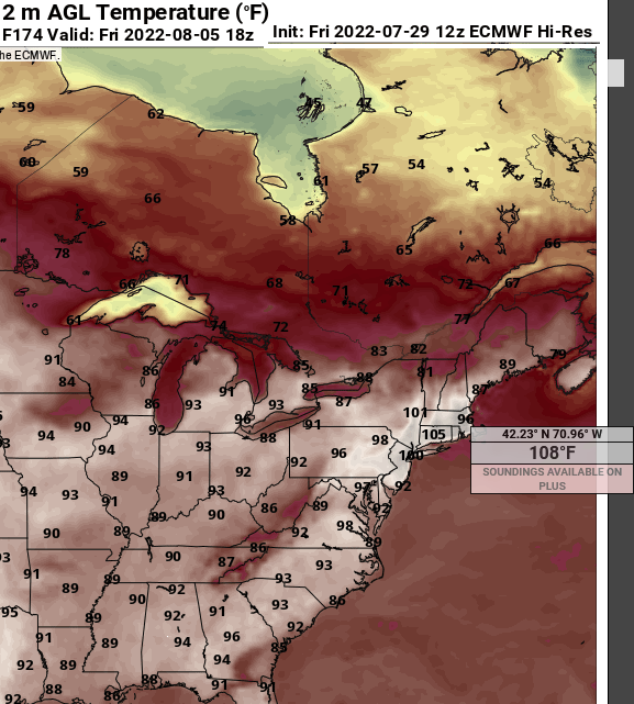
Heh. Pretty sure if that 21z Euro max T happened it would be the hottest day ever in our local climate history. Even if one or two points in history matched, the regional integrated e-V would have no match so deep that ORH is the same as ASH… and it’s 98 at 1200’ Winchendon … that may be on par with the PAC NW’s SD But this is akin to drooling over a juggernaut on a D 9er chart in winter
-
That EPS 500 mb anomaly loop off the 12z looks pretty f’n ominous tho wow
-
Not that the NAM is much of any use to anyone but .. the T1 would support a 2 meter T of about 31C both tomorrow and Sunday over Metrowest of Boston. I mean, 88? brrr It may be very dry with low DPs and all, but like every outlook that has ever existed since about 1998, we end up having to eat the over crow come time.
-
FIT
-
Synergistic heat though ?
-
We're all doing the 90/58 down here ... hot, but because the HI isn't terribly high we don't get to complain about it
-
Mixed ideas... I could see the dry feed back part, but "definite" isn't a term I'd prefer to use in the context of potential, for "100+" in deference to New England. The signal for a hot spell ...we've beaten that dead horse. But it's been such a long lead we're waiting days and days and days before getting a more confident feel. Climate argues no, duh. Euro has a BD tickling the nut hairs of NE Mass D9. You know, heat is the most fragile, corrective metric of all weather related highlights at extended leads. It's really there on the charts because everything else pulls away and leaves the region alone - anything at all passes through even minoring, it may mean 15 F lopped off the top.
-
If there is a big heat day(s) in that range, it is still out in the GFS's tendency to suppress the westerly jets and mash the planetary system toward the equator. It did this all last 5 winters in a row, and we see vestiges of it in the summers in the form of this kind of compression south along the Can border. That said, they could both be wrong about the areal significance of that that period, in which case the Euro comes south and the GFS goes north, and both have to correct toward 92-96 ...which is probably the climatological safe route at this range anyway. Then if some kind of freak show synergistic heat bomb finally comes here ... we'll see that emerge with more confidence in time.
-
Just posting about that in the August thread ...seein' as that is August... heh But yeah, gonna go ahead and assume the Euro is too well mixed/tall with the adiabats. It's 22C at 850, which is impressive for this region, but that really supports more like an impressive 102 as the ping max, considering our deeper pressure well and how hard it is to expand that -
-
Heh...that D7 is 104 at Logan, easily - don't have to look at the 2-m .. but it has 106 as near-by as Cambridge LOL Not sure the 108s out in Framingham is real ... or any of it for that matter... lord Not sure how it keeps Logan 96 given the surrounding synopsis ...but, that hover temp there is out around Waltham or so
-
I guess it pertains more so to August ... but that's quite a Euro look for D6 through 10 Backdoor contention D9 ... if that fails, that's 5 days straight of 97's ..probably 94 to 102 from ORH to BED, with some history potential.
-
Now the GFS is back east with the thermal ridging... not sure I buy it with all this instability and squabbling against it's own ensemble mean. I still lean warmer than normal - no comment as to the extend of what that will mean for civility. Although..I do sense that we may have two days of 90s, then a half-assed relaxation for two days, then a longer heat wave ... all fitting inside the next 10 days to two weeks. ...something sorta like that
-
No idea this was even happening... https://www.cnn.com/2022/07/29/weather/kentucky-appalachia-flooding-friday/index.html And that St Louis flooding last week? It's really been a stalled boundary in that vicinity. I remember reading this in my adolescence. "The American Weather Book?/Almanac?/Atlas?" - can't recall which ending in the title. It was thick-ass 3 incher, packed with essays and photos and weather charts that described every phenomenon there is in weather and climate, associating maps... gray cover. Awesome. Hours of focus like a late Millennial walking off curbs over an iPhone enthralling... but 1979's version of the distraction: actual books. Yeah, gaslight intended... But there was a discussion in there about how the greatest floods come from either tropical disturbances, or... stalled frontal boundaries.
-
Yeah... not withstanding the 324 la la range ... it still illustrates how the operational and the ens mean of the GFS keep divorcing out in time. It's been more prevalent in the extended, so I haven't personally been bringing it up. But we are here about to either set the table for a signficant heat wave, or... miss one ( perhaps MCSing instead) ... and this discrepancy in the GFS system is smack on when they tend to have their marital blowouts - Euro's also being peevish with heat moving into its extended but it's not abundantly clear it's for the same reason. They both have identifiable bias behaviors that are distinct as far as my own experience.


