

Typhoon Tip
-
Posts
44,235 -
Joined
-
Last visited
Content Type
Profiles
Blogs
Forums
American Weather
Media Demo
Store
Gallery
Everything posted by Typhoon Tip
-
It has been a very coupled fall into the early cold season so far…
-
That’s exactly what I was thinking… and then zonal tends to precede ridging. We’d be heading for a 2015 Christmas as one possibility in extrapolating that extended GFS. Man I thought for sure this was just a one GFS sort of aberrant run… likely more meaningless against the weight of everything else. But then I looked at the weight of everything else. Jesus Christ. Some 70% of GEFs ballast agrees on cutting 13.14.15 as a deep low, -NAO or not. Out of nowhere, it’s planetary scaled continuity break - but it doesn’t fit the NAO hemisphere climatology I guess it could happen… I mean if we think about it the models can’t produce solutions that are physically impossible unless they’re cartoons. From what I’m seeing in the series though is that the Pacific is the problem. In fact for the last several days it has been meandering east and west with the planetary wave spacing …sometimes we get like yesterday and there’s more western North American presentation and the models immediately ignite massive storm system because of the incredible potential this pattern has downstream or eastern North America. This run en masse went so far the other direction it should strain believability. But it’s not like one or two members and the operational run here you’re talking about the entire GFS machinery. So much it’s sending a nonlinear wave function that’s encouraging the NAO to back load southwest towards the great lakes and we end up actually borderline turning this into an Indian Summer… Wah wah waah I mean the old mantra about continuity break 101 means you don’t really believe it and all that jazz is true but when the entire forecast system bullies that it all at once - whole scale - its enough to give one pause. I guess wait on the EPS and we’ll see if the euro and all that
-
So we’ve got the EPS absolutely gorgeous and the other extreme we’ve got the GFS, absolutely atrocious makin progress
-
The following statements for comic relief so don’t take it as trolling but I’m looking at the Gfs’ December 18 depiction of 585 Heights over Boston and I’m laughing at the prospect of any kind of snow haha. Jesus h Christ not to mention a “favorable pattern”. Run for your lives
-
The complete reversion back to what it was doing two days ago… It seems to be fighting the NAO exertion like it almost just loses it from time to time no times. I just think it’s not handling it well. None of the models are practically well probably
-
I wonder if we can get some mood stuff just like in the air on Monday. that is a really long fetch coming off big polar high. we’re gonna have a nice Northeast flow so it’ll probably be too warm obviously over east zones down toward the Cape and southeastern mass …but inland up the Worcester hills if we can get some kind of stuff in the air
-
The low here was 20. Currently it is 45 that’s a pretty impressive recovery for this time of year spanning just 2 1/2 hours
-
they don’t appear to be. The constant unrelenting back-and-forth replaying the same content does not appear adult and lucid about this material, not to any objective observer.
-
I don’t know… I think you folks need to focus on 13.14.15 We have to adult and except. We have to except that’s all that there really is out there - right now - that’s realistically providing the best odds. I dunno, maybe you don’t believe it. Or maybe you don’t understand it. But those are the best dates right there. All the odds on the table and scaling your best odds are 13.14.15 and everything else is just some kind of rocking back-and-forth and sniffing armpit antics … darting bloodshot eyes too and fro. Lol.
-
Yeeeah 17.18.19 is legit enough for early place holder awareness… Chuck has a thread started I believe. However if we get a significant event out of 13 1415 we’re probably going to cost some for anything that tries to come by just two days later part of the problem is that we have a progression or velocity bias in the flow unfortunately… Seems to be a recurring theme now spending many years frankly. Even in this strong blocking episode the models are trying to orchestrate a fast tendency. And it may not even be real - it’s hard to tell But wave spacing and atmospheric recovery/physics are real contention concerns. A significant event passing through the region between 14 and 15th tends to be too close for the 17th. it can happen… We did something like that 1996. But there’s a reason why we can count on one hand in 30 years how many times that happens
-
The thread I started is under the auspices of ‘risk assessment’ for 13.14.15 Not so much about the totality of the hemisphere that it is embedded within if that’s what you guys are talking about? I feel 13.14.15’s signal is strong enough that it deserves selection out of the daily din … I haven’t seen anything overnight to dissuade me from that sense, either. In fact if you look at the EPS and GEFs spread so you can see there is a tendency for a miller b now - very primitive attempt at coalescing. Yesterday the numerical PNA was showing an elevating index during that time frame while the NAO is relaxing. I haven’t seen the values from last nights computation just yet. But we are early in the signal so it may wander in and out or coherency for a little while - should be expected.
-
FYI gents and gals I started a more focused thread re 13.14.15 … I did pay homage to 9.10 I think 9.10. is one or the other, with regard to cold air… If the surge comes in from the east and it’s cold enough for that to be oes and grits and so forth the storm is probably going south.
-
Hell freezing over apparently … cuz -3 SD NAO under a -4 SD AO is somehow not enough
-
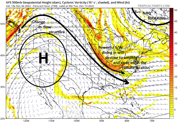
This is admittedly unusually early, but it is intended for risk assessing, which 10 days is not obscene for that sort of effort. Therein, it is time ... I feel it's worth it to start a more focused thread for the 13.14.15th of the December. The 9.10 (dates) event in the foreground is noted, and not intending to ignore that possibility. However, that one may not actually time within the span of the western ridging, which is why ( ironically ) the better, given to better large scale synoptic scaffolding, is the 13.14.15 prospect - and why this thread is focused there. But again ... hmm, this is not intended to ignore 9.10 altogether. Both have frankly been suggestive is statistical correlations for over a week of guidance monitoring ... There is possibility ( among a plethora of them, frankly) 9.10 could 'steal' the show by slowing down and/or stalling due to the NAO exerting hemisphere, which would introduce wave spacing and a tussle in future guidance - cross that bridge. In the meantime, this for the overall rudimentary canvas being in place and is/has been well covered, while now ( and perhaps most important) the the Pacific relay has been changing in favor of a better showing of ridging in the west... Below, I have annotated the 18z GFS for explanation purposes only - although it's essence/principle did not deviate too significantly from the 12z re the period in question (13.14.15) it is too early in the ball game for deterministic slide into home base. Perhaps as an homage to just how sensitive ( and volatile) the ambience is over eastern N/A, almost immediately upon the ridge above presenting, ...the operational models waste little time materializing these illustrations. For now, all three more dependable guidance sources flagging moderate to major cyclogen from the Del Mar to CC region 13.14.15, and I do not believe that is mere coincidence. It fits the footprint of the mass field modes/modalities: relaxing NAO https://www.cpc.ncep.noaa.gov/products/precip/CWlink/pna/nao.gefs.sprd2.png rising PNA https://www.cpc.ncep.noaa.gov/products/precip/CWlink/pna/pna.gefs.sprd2.png It's an interesting time to observe how the models resolve a complex Pacific relay that is dynamic, into a realm that is being forced to slow down by the might of what's proving to be a rather 'immovable object' in the NAO west limb block anomaly.
-
I snickered a little to self when no sooner do we have the ridge returning to the west in guidance, ...the GFS has to move to borderline wave spacing issues. can't f'n win
-
Yeah...detecting a primitive coalesce attempt on the 13.14.15 period - it was one of the original assessment intervals from last week. probably be a thread in-coming later, if anyone is interested? I feel it's worth it for the fact that the rudimentary canvas in place as is/has been well covered, while now subtle Pacific changes showing up in the EPS/GEFs.. Almost immediately we see this illustration materialize in operational, with all three flagging moderate to major cyclogen from the Del Mar to CC region. Sorry, that is not a mere coincident series/converged guidance'.
-
Did you go pro it?
-
yeah, I was just having fun with the GGEM's "ominosity" ( did I just make up a new cool sounding word... nice). But in more practical terms, ...didn't we see an exotic solution from the GFS like this ... 4 or so days ago? It just really hearkens to the range of possibilities here. I posed a little quiz to the general audience but will give away the answer, just cuz we're talking about it - the defining difference here is that we're getting more actual western ridging in after region of these trough ejections. It's amazing how important that is in the total morphology down stream.
-
man...overload of eye candy and talk-about cinema available across the pantheon of movie theaters this mid day. lol - this is awesome... That GGEM solution... really really needs to go on thru the next 18 hours. That is a crime letting that sucker stop on that frame. haha. That's heading for NESDIS rating of about a 20, on a scale of 1 to 6(?). You can see it at 500 mb, that jet max isn't even total, where the DPVA is located in the positive aspect of the trough... There are 125kt winds diving/rounding the base. The 500mb gradient over MIA is perfect.... lower than 582dm/light winds. Zip inhibition for digging, so ALL those wind momentum get conserved coming around, within the trough structure and no absorbed by the surrounding planetary medium. = DEATH. period, that is over the top like no one's business and is not some boner vision -that's what this model is doing... sorry. It is. The trough axis is shifting E while decelerating ...such that it's going to become something never seen before. Period. Gotta love the GGEM ( ) model.
-
K, little pop quiz see who can answer this correctly. what is the main perhaps telling and important difference in this solution as it pertains to the handling east of Chicago - and yes, ...this is bordering on a trick question to really test the knowledge.
-
Exotic blocking event ... to use George's vernacular, historic in nature. Whether we are destined to this becoming real or not, this type of extremness might be creating panoply of oddly handled (co-mingling) metrics? Like concurrent 531 dm, 5 contoured closed -4 SD ... 1978 beating 500 mb black hole, with saturated 850 mb temperatures that warm underneath. Wrong. First of all, that is almost thermodynamically impossible. The saturation vapor pressure of thickness that low won't allow a saturation in liquid form, so it makes it very dubious that the undercarriage could sustain that layer profile. The pseudo-adiabatic gradient would become too exotic to be supported.
-
That's utterly flawless aloft, that structure. Yeah, in more analytic terms ( I'm just yankin on the previous post...), it's very unlikely that the mid level heights would fall to that depth and we'd stay that wet. Didn't Chris just discuss the "intent" of this model's recent upgrade, to correct bloated QPF under snow columns? Hmm. Interesting. I almost wonder ... did they fix one thing by breaking something else. I remember that system in 2017 March, that had a problem with cold sector QPF being terribly managed with 39/31 in 3" total rain ... I recall a lot of anticipation that maybe a better wet bulb reality would make that more snow - what actually happened was 33/32 cat paws and cold rain, but still... it's not like this model has always had really good BL thermodynamics.
-
Oh m g ...I just saw that GFS serious.... ha HA hahhahahahaha God, that's beautiful. Three moderate ( if not more) nor'easters thrash the region in rain, during a -3 SD NAO. I'm a Science Fiction author, I'm writing my first 3 chapters of that story with that occurrence, as a kind of sneaking attribution case study for CC. You just create the fiction of it, and let the wise reader wonder if that's where you're going. muah hahahaha.
-
The cracks in the shovel full's would probably be the same color oh wait , is that rain? yikes
-
That's a delicious cinema though.... the 246 frame would probably arrest breathing. Boy, the need more hot dog venders in the modeling core to encourage letting these kind of movie reals go out further. HAHA


