

Typhoon Tip
-
Posts
44,235 -
Joined
-
Last visited
Content Type
Profiles
Blogs
Forums
American Weather
Media Demo
Store
Gallery
Everything posted by Typhoon Tip
-
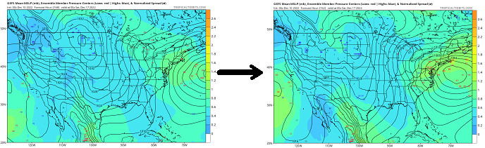
Still a couple pages back ... but if it's any worth, the overnight GEF mean was hugely improved ( for winter enthusiasts ) wrt to this system over the prior mean/spreads.... The prior wasn't as freakishly miserable as the operational 's rather abrupt deviation toward oblivion during those 3 runs... but it was mid way. Don't want to over emphasize here ...but, the 18z GEFs late yesterday afternoon was beginning to side with the operational run, with only a vague impression remaining... escaping seaward. Here is the 18z vs the ensuing 00z Almost smacks as though some bad data got absorbed into the DNA of the handling during the last 3 or 4 cycles, and we've been getting green-eyed babies ...stressing the father's faith and trust in the mother. But the 06z mean leaped quite a bit back toward a major risk avn, with some members in there beneath climo depth, too. Yeah...stating the obvious, also... this is all beyond 120 hours, this last run -away child consternation... Maybe expectations for stability in the guidance isn't proportional to modeling skill.
-
I missed the red eye flight overnight (still back around page 145 or whatever too many this is) but... the morning note was that the 06z GFS made a significant move back in the other direction ... However so telling that is, remains to be seen. In my snark late last evening resides elements of truth ... such that the previous ... I think 3 cycles of that model, the first in the series of which it went from a complete juggernaut on the previous ... to modeling that state of affairs on Pluto, neither of those 3 runs looked very much like the other. In other words, it was a continuity break to leap from the previous into the abandon state, but then it could not establish a consistent vision within the 3, either. So good luck parsing that out before 9 am on a Saturday morning... But upon seeing the 06z solution make at least a paltry attempt to rejoin the pack ... does two things: it pulls away from credibility over the recent GFS runs even farther; makes me yet again existentially question my purpose of being when I'm spending this much time writing about it
-
The only problem with Canadian is that at 156 hours out it’s not quite in its wheelhouse yet. It’ll be into its wheelhouse in another 156 hours. That’s when confidence leaps over 50%
-
I feel like we should be getting a statement from NCEP operations stating that they’re taking the GFS off-line for emergency maintenance If you look at the last three runs across North America the only thing consistent is a state utter entropy. And it’s plate of spaghetti with a different construction to the synoptically layout everywhere on each run. Weird.
-
I'll tell you one thing for certain ... should this freak pattern look go on to verify, there will be no question as to which model was superior in detection.
-
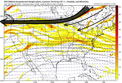
I would argue it's even more sheared in this run, actually.. It's completely rushed into oblivion promptly after 102 to 108 hours....within a day it's completely been destructively interfered down to a shear axis. I've never seen that before. It's as though it has brought the entire Ferril trade band all the way down 45 to 50 N. It has an easterly jet at 500 mb from SE Canada to lower B.C. My personal assumption is these runs are in error ... but who knows. It's an abrupt change ...nooormally that's a red flag in itself, but model wildness isn't uncommon in the extended. Also, the NAO is a suppression factor. I think though doing this, that abruptly on D5 is a little more odd than normal though, particularly when the ensemble mean is divorced from that idea, and cross guidance doesn't agree much either. Strange... some conflicting arguments here, but it seems the weight is against. That above is about as suppressed as is imaginably possible within Terran physics - mooshed to non existence.
-
That would be amazing for winter enthusiasts if that extended worked out after the storm… Transitioning into a monster negative EPO with massive cold load into the Canada … Solid moderate to major snowstorm followed by protecting cold Even hints of a multi stream phased solution rotating around if the 10 were allowed to extend longer. It’s always on D10 tho that’s the rub
-
Yeah that’s the one I think I was thinking of that one way back in the day. Ha. Weird But I just have all kinds of abstract memories of other ones too
-
I’ve also referred to these as ‘Minnesota squeeze’ which I have since the days when college was useful to society … It’s basically whenever you get a trough eject through the west and it runs into resistance and can’t curl up into a Canada as cutter… they usually don’t make it though… They start to pancake and open up as they approach the Ohio valley often times still enough to give us an over running mess or perhaps a New Jersey model redeveloper. Like Will or whom that was just said said though the euro just has an absolute shit ton of mechanics and momentum it’s got to deal with so it ends up stem winding. Yeah I would definitely take this model with a grain of salt at this range because it tends to over amplify beyond D5s , and this whole scenario is giving a carte blanch to exercise its native bias. It’s almost like ecmwf.org called up George and ask him what the model should look like today… He told them the end of civilization as we know it of course but … they decided that was a bit too out there so we got this compromise.
-
I also think this pattern as a hemispheric scope between day 4?and roughly 10 is modeled to enter a rarer type of set up… perhaps even unique. Maybe a tad of “uncharted waters”!there
-
I’ve seen it before… I’ve been referring to it as a “tumbler” during the day for fun.
-
… You know that reminds me of 1992 now… I don’t like to compare anything to that one because I hold that one in very high esteem lol. But it does when I’m not at work later I might look that up in the library
-
At least one trustworthy model has to trip dopamine switches… That’s all that matters - This is why NCEP can’t get forecasts better than 50% accurate outside of four days … Their analysis method is way off
-
Probably should put this in the thread but… Did mention this last night there was a trend to weaken it as it was correcting south regarding the end of week next week. But you know it’s probably going to disappear and come back and disappear and come back
-
Not to be a word fascist but don’t drop words like blizzard in either case. I realize this is a public Internet depot… But that doesn’t mean it has to be a cartoon starring ‘Ralph Phillips’ daydreams, either. For some of us we actually care about substantive analysis and adult reasoning. Ha Seriously… At this range a ‘significant winter storm in the plains and in the east from the same system’ would’ve been plenty sufficient and doesn’t have to press every event to the ceiling of what’s imaginatively possible…
-
Yeah my bad. I coulda been more clear in that regard. It was probably confusing just bringing it up at all but I happen to find things like that interesting, how you can do cut outs and compare pieces to other event metrics …as much as you can do wholes? A fascination perhaps only understood in the mind of the disturbed nerd ha ha
-
Hey Will… So it appears that the efforts of the stormchaserChuck and myself had stumbled into having two threads for the same suggestion - but it’s kind of complex in terms of risk assessment vs having an actual system within that manifold to hone. It turns out that it was just a long duration system that starts at one end and ends up at the other… I wrote some notes about it in those threads. from my perspective fwiw we are nearing or are at a target system. So I was thinking about having a new thread coalesced of those two, or perhaps starting a new one altogether? either way, so that the December thread doesn’t end up having 500 pages before the 15th of the month - just a suggestion. Perhaps it doesn’t matter but this thread’s already getting kind of long to really keep track of them all, as there are other threats after this one. I don’t think we’re done through the end of the month.
-
Hence “… I’m not saying that’s an analog… “ lol. no but I was speaking to the 500/ ML evolution … The 7am analysis on Jan 7 1996 reminds me somewhat of the 00Z GFS’ 174 hour.
-
Updating ... It occurred to me yesterday that the effort put out by "Stormchaserchuck1" for the 15th-17th and this one are in fact the same coverage. The origin of the storm genesis - if so ... albeit appearing more likely, despite the long lead - is born of the same synoptic. The 13th and 14th sees a strong Pacific inject over the continent in the west, that quickly maxes in the high Plains.... But the instructional nature of the blocking that's both new EPO and existing well-modeled -NAO is really quite preventative for polarward migration...so the coiled up mechanics et al are being corrected S. This is quite obviously more so apparent in the recent GFS runs, but as others have noted... the EPS and GEFs have been steadily matriculating new members into a Miller B commitment toward the end of this next week, which is the 15th - 17th window. So a bit confusing, but...this was an early risk assessment originally...appearing successful. As far as how all this unfolds along the EC/New England coasts more specifically...that is still D7.8 from now, so we unfortunately can't really be too confident... However, I feel this system is well above the "model-error-climate" and probably does perform in some fashion. As we move forward, the "correction vector" is still S...although the recent GFS operational runs may have actually gone about as far S as this can go. There is a limit to that vector, based upon the fact that the SE ridge/La Nina foot print hemisphere is still lurking. It would be more likely from this point forward, that the GFS would tend to start smearing the tumbler trough into a flatter system with possible multi-wave event....if the suppression were to continue exertion. That's supposition, however. Both the Euro and Canadian have room to correct further. The EPS did appear to collect additional members into the Miller B envelope, but the signal was no improved over the 12z prior run. Plenty of time... So long as the hemispheric mass-field are modeled and that persists, I don't really imagine a scenario where the total tropospheric manifold of forcing with this would end up N of the 45th parallel ...while west of 80W.
-
It actually occurred to me yesterday that the 13.14.15 event I was covering is actually the same event as this one… We were honing the same aspects; it’s just the morphology of how this has evolved has made the whole of it a 3 to 4 day ordeal. It starts in the Plains, ~ 4 days from now … and it’s a tumbler that takes thru the 17th to clear the EC. Starting to remind me a little bit of that 1996 January event; that was a tumbler that rolled along and eventually ignited the big storm on the East Coast. I’m not saying that’s an analog. I’m just saying the behavior We both have threads for either end of this pig is what it amounts to
-
I’m not saying it’s doubtful… I’m telling you factually the models have been trending weaker when moving mid range events into the shorter term for a decade. I mean it’s something that has been going on. We’d be remiss not to consider that trend. by the way that’s a 1978 polar high W-N wow
-
You can clearly tell that the GFS is too warm in the boundary layer again at that range, because there’s no way given that 700 500 mbar integrated evolution that that kind of sfc evolution is going to happen unless there’s a lack of cold air north of the circulation - which that’s unlikely given the antecedent conditions with the block and so forth. So yeah we’re talking about a solution that’s above the 85th percentile at 180 hours ? Mm. wouldnt shock me if this goes back the other way for a run or two before it comes back again but I suspect in the end the result is S.
-
It’s one run it’s hardly a consensus. Look I’ve been talking about model magnification and having a shed momentum in the mid range for about three years it’s a reality that’s not going away just because it needs to placate this addiction to model cinema shit. Sorry for bringing up realistic reasons to temper enthusiasm and not let it get away from you.
-
Sorry dude. That’s unfortunately realistic.
-
Yeah just looking at that 500 mbar evolution with a multi contoured mid level quasi cut off low deepening further while moving slowly underneath Long Island …there’s no way to estimate the frontogenic pounding that’s capable of in that evolution. just be aware of model magnification.


