Typhoon Tip
-
Posts
44,235 -
Joined
-
Last visited
Content Type
Profiles
Blogs
Forums
American Weather
Media Demo
Store
Gallery
Everything posted by Typhoon Tip
-
That whole surface evolution is premature for what’s going on aloft… I’ve noticed that with some of these models that are further east with everything they’re so sensitive to the baroclinicity that’s like a powder keg that they’re spinning up lows prematurely
-
It’s just ahead of the GFS by probably two or three days …around DAY6 and it’s really got something historic lined up on the eastern seaboard again
-
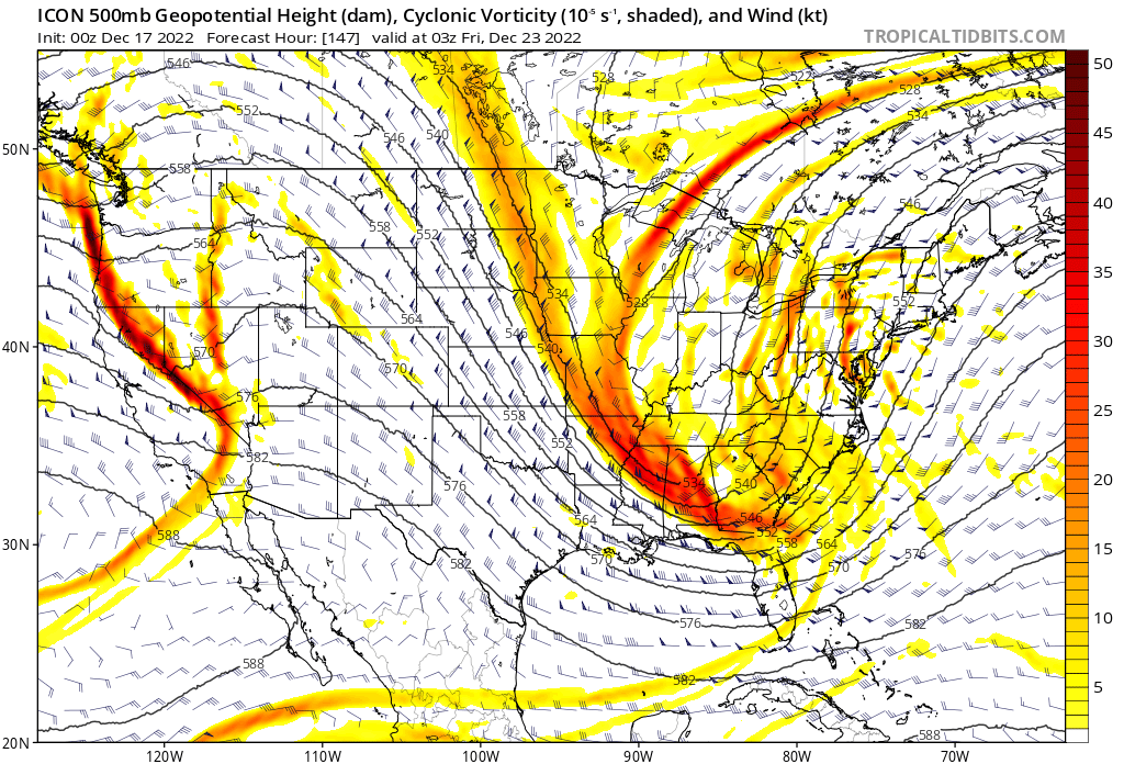
This ICON model looks nuts!
-
You’re ICON’s an icon for a bomb … right back where it started from. Looks like it’s headed for a violent solution too I’m not sure about this icon model in general by the way I’m just posting it for the muse of it For what it’s worth the western ridge is coming bodily in this time
-
Preliminarily ... a medium impact partial Miller B, Friday
Typhoon Tip replied to Typhoon Tip's topic in New England
Soaked cotton balls kicking in now... 34... Seems we got a legit T correction ... was 41 an hour ago... -
Preliminarily ... a medium impact partial Miller B, Friday
Typhoon Tip replied to Typhoon Tip's topic in New England
Fwiw - Ayer is 35 with cat paws on winshields -
It's important in the sensible weather... it's just not a driver... I mean duh...if it pins over N Ontario, and say this thing stem winds early ... this becomes a 'Minnesota squeeze'. Yeah...all being unfair in this p.o.s. world ... it would be better to get a squeezer over a 1994 southerly gale, sure. What you describe is the squeeze under idea But, the ridge is what determines that S/W's trajectory in the 'dive' ...It's going to ride the ridge - that's just it. There's a complex aspect to this that I'm leaving out ...because I'm not sure other want it... But, a steep L/W over the Conus does delay the internal S/W break timing, because the curvature of the large scale offsets the PV of the trough, so it remains more open until it hits the bottom - ... blah blah. The foreign models are interestingly less PNA mode change --> +PNAP
-
Again ... and nothing's forcing me to see this otherwise - The amount and position of the western N/A ridge is > 50% of this... The TPV ...SPV whatever we wanna call it, is not driving how this thing behaves over the continent. That feature is there because of the non-linear wave forcing from Rossby dispersion down stream of the Pacific, too. Anyway...those guidance' that were Michigan bound clearly demo the flatter ridge and early wave break over the midriff of the continent, resulting. The GFS has been different in the relay construct from the Pac over western N/A ... Frankly, I don't know which is correct. But... the wave it's self is very real - how the large scale pattern delivers it, that's what's really in contention among the guidance. I will also be the first to admit, ...I thought the western ridge would trend more robustly - As I've advertised, there is a whopper mode change in the PNA ... it really should deliver a +PNAP response down stream... Unfortunately, if that ridge pops as a west biased variant, that would be less useful for local winter weather enthusiasts to put it nicely... Remains to be seen.
-
There’s not much that is unusual or very extraordinary at all about that kind of variance at 160+ hours. It’s clear that people need (almost to the extent of an addictive response) steady trigger of thrills from the modeling cinema, and when they don’t get it… it really becomes intolerable both for them, but also for anybody that’s trying to just engage normally with this site – unfortunately.
-
No the clear difference with the GGEM is that it’s keeping the heights flat in the west over the relay from the Pacific Ocean over North America. … so there’s a ton of short wave mechanics delivered there but it’s just not “waiting” to break. It wraps up early over Chicago and so forth. I think it’s pretty clear almost to the point of cut and dry that the GGEM has to be correct about that orientation of the flow west of approximately 110 W. There doesn’t seem to be any factor controlling why it’s doing that at least from what I’m looking at …otherwise it solutions gonna be way too far west. Which it might be right to keep less ridging until the west….I don’t know. My first impulse is to say it’s wrong though because that ridge is rooted in the rise in the PNA. It’s also a continuity break in fact it’s last three cycles it’s been all over the map with trough handling Fwiw, that’s really kind of true for the last several cycles of that icon from what I’m saying. I don’t ever look at the UK met
-
I swear I was just internally musing that… And frankly I thought that yesterday per one or two runs as well GFS was taking a lot of really deep routes through the northern golf interface establishing some very low surface barometric pressure really low in latitude. Heh Maybe we could do what 93 failed which is to have that low come another 100 miles east because it doesn’t do a lot of good to get 3 feet of snow along the ridge line of the Appalachian mountains after 12 days of histrionics by the weather channel lol I’m just being a jerk there in kidding
-
Well hopefully people can make the distinction between hyperbole over a single model run… Successfully separating that from an actual objective prediction. Because I’d like to express myself here and say that that GFS solution is a wide area multi regional destructive coastal bomb - wow
-
If the mere site of an averse weather chart is enough to erode on peoples nerves…this 12 Z icon solution will be a kin to taking a soothing warm bath in battery acid
-
Preliminarily ... a medium impact partial Miller B, Friday
Typhoon Tip replied to Typhoon Tip's topic in New England
Well… Keep in mind that there’s also an ocean wind component to this in the first half or even 3/4 of this thing blowing in straight from the east really that probably penetrated all the way in so that’s skewing the distribution around that forcing, too -
Preliminarily ... a medium impact partial Miller B, Friday
Typhoon Tip replied to Typhoon Tip's topic in New England
Similarly… It’s 39 here in Ayer but it’s 41 over in the Littleton line; then the other way just 4 miles W it’s 34 and snowing. This is the situation where that rain snow line’s going to creep south during the day Like 2 miles an hour as the storm begins to curl around south eastern mass and the wind backs in the interior and all that obviously you know that’s just saying for the general reader. I think it’s interesting that the euro finally caved to the GFS position being slightly more south east -
Not to be heavy handed or holier than thou or anything condescending ... (really) but just an observation... Saying 'nothing is going right' regarding a system that is still a week away is kind of amusing. Maybe we could all benefit from resetting expectations for starters ?
-
I'd like to add more to his ^ idea . (Try to stay lucid and objective, even if the reality of this is a bit abject ) West oriented/biased PNAP responses to rising +PNA signals, are not good. He's right about the confluence as well ... (that's also directly or indirectly related to mode/modality within western limb of the NAO), but crucial to the evolution/emergence of what this signal will ultimately become over eastern N/A, is very related to the behavior of the Pacific relay into western N/A. As was the case last night's 00z Euro ... a ridge axis collocating with the WC is skewed from climatology (anyway), but you can see that mechanically playing out in that as the big ejection into the flow of the powerful wave takes place ... it is slicing SE earlier than is pleasing to the eye, consequently the wave starts to break too soon ... The natural question becomes whether that is correctable. From this range, the auto response is yes... I'm sort of wondering if the signal is so big that the moving parts might be more stable than usual. On the other hand we can mull around with ideas over whether this is just anomalous - as all systems have their own eye-color that deviates a little from the tribe somewhat. We can certainly/plausibly send a bomb S of LI on a west-biased PNAP surge... just as much as we've seen systems cut to ALB with -NAOs... It's certainly not etched in stone for a system that's D6..7.
-
How is a 963 mb disorganized… Lol
-
Other than inconsequential differences … another near identical GFS depiction of intense amplitude carving SE over the MS valley. This appears destined to another explosive result.
-
Preliminarily ... a medium impact partial Miller B, Friday
Typhoon Tip replied to Typhoon Tip's topic in New England
32/31 at night should locking. -
Preliminarily ... a medium impact partial Miller B, Friday
Typhoon Tip replied to Typhoon Tip's topic in New England
It’s looking like this will require height falls and fall rates to be meaningful. Now casting…. There’s not much of either this hr but it’s supposed to step up after 12z I think -
Preliminarily ... a medium impact partial Miller B, Friday
Typhoon Tip replied to Typhoon Tip's topic in New England
37 and drizzle yuck -
Nah gotta go societal
-
Fwiw, it's a historic in depth no question... It's sub 965 in the Boston Harbor. I'm not worried at all about ptype, despite this run running liquid as far W as ORH, because that's clearly model BL hallucinations when the 500 mb is < 520 DM in the core of 4 or 5 contoured isohypsotic canyon. That's likely snowing everywhere accept the elbow. You almost want the model doing that at this range in a weird way...