

Typhoon Tip
-
Posts
44,235 -
Joined
-
Last visited
Content Type
Profiles
Blogs
Forums
American Weather
Media Demo
Store
Gallery
Everything posted by Typhoon Tip
-
Very fortunate for California .... They're likely to get a couple decade foot of snow in the Sierra, with substantive rain fall below in several pulses over the next week. It won't be enough to correct the "Millennial drought" - I mean I'm calling it that. The hydrology out there must be an interesting science. About 10 years ago there was a better wet season, and a lot of reservoirs recovered quite a bit... it shorter order. But that needs to happen in more than once per decade, or does the sustainable habitability for 40 million population become an issue, or remain viable by mid century. Wondering thought ...
-
Or maybe they need 'relationship' counseling -
-
this is kinda of cool looking... having the Pacific jet align from Tokyo to San Francisco with pretty much 0 deviation from a straight line. heh http://mag.ncep.noaa.gov/data/gfs/12/north-pac/500_vort_ht/gfs_north-pac_156_500_vort_ht.gif
-
Ha...easy - cuz then what happens finds a way to be worse than that 'worse' you planned for. lol
-
Are they even favored in this QBO run up ? I can't seem to ever remember the - vs + relationship there... possibly owing to how significant they are to me. haha. Seriously though - I guess I'll look at it.
-
yeah...agreed. I mentioned those dates a couple of times over the last few days myself. there's still a signal there, too, but it's weak. That's a good way to put that, "chance for anything". The trouble is, you mention and then people can't help themselves but to start checking on the status of their allotment of modeling cinema that was actually "scheduled" for the time frame in question. Haha. Fwiw - the discrete anal analysis of the 5th - 9th/10th ...there are actually possibly two events in there. The first is what I have/had been suggesting, in that we could correct toward +PP over SE Canada and we are seeing that emerging now in the last couple of cycles of the operational GFS. The Lakes cutter wave for the 5th has a leading dammed signature, out of a 1040 mb high trying to lobe around the elevations and the upshot is that it is under 200 hours out in time. Later on...there still some vestiges of a coastal trying to hang on... As you say, the Pacific handling in a longitudinal flow like this is probably right at the tilt point of model performance. There a examples in the Kocin/Ucellini books of these waves that came along and broke nearing the EC whilst there was very limited aft side ridging in the west. It's just the rarer format. So you know there's some shit out there.
-
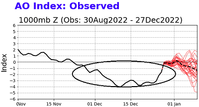
Just no one asked me but I'm not sure any SSW would really be very coherently noticeable above an AO index that has been convincingly behaving in the wrong correlation space already - and already negative. If the AO persists in doing what it has been, any SSW's eventual time-lagged influence on the domain would be absorbed in the cloth. I mean ...I said 'wrong space' there, but the correlation coefficients between it, and the rest of the planet, has the AO operating in the lesser correlation likeliness. It's not really the point I was making though. I have been watching these SSW and their apparent effectiveness in modulating the AOs since I first brought this to the attention of the forums back in 2005 ( jesus christ...), and I was admittedly more hot to trot about them back whence, than I am now, for that journey. There have been those that have come and gone ...no influence on temperature anomalies over N/A.. Then there were those that came and 20 days later, there was... So flip a coin. I have come to a fairly confident conclusion that they are the polar version of the MJO in terms of how/what they can do to the system. They modulate, don't drive - ...so I'm wondering in my point yet again. Seems I do that a lot. Ha. Well, maybe not wondering too much, because those years of being non-parse-able within destructive interference hemisphere ( 'cloth') is that coin flip. Indirectly related aspect.. We've had this conversation before ... telecons have been disrupted over the last 10 years. CC or random patterns emerging out of complex systems that lie ... whatever fits our narrative(s) being the cause. I don't know if that is related? Could be. But below was not just oddly spaced below the 0 SD line, but represents a truly massive integral .... And doesn't just go against the correlation. It does so with mocking audacity. Especially considering the robustly well established, coupled La Nina. SSWs in the data, in the past, don't cause what we see above - not to that extent. Also, the spread out there is not ignored and relates to my feelings on January.
-
I know. But as far as the pattern and the general reader: it did change. It changed for the better, too. Clad and true. It didn't produce. Tough shit on you. That's life. That is the breaks. Pattern change does not automatically guarantee jack shit. Let's adult this for a minute. This engagement is with the public... pointing out the obvious. Engagement in the court of public opinion is purely "an objectively, fair, and cutting edge intelligent" adjudication. Once one survives that comPLETELY non-persecuting pat on the back by the Lord Of The Flies... there is then the reality that we got a historic bomb out of it, one that same judging consortium is grumps acknowledgement. haha. Sometimes this feels like we're trying to appeal to a psyche ward. Just saying ... in general. Tough shit. I don't know...I consider the whole thing an incredible success actually.
-
I'm glad you put that in quotes for that particular time frame, because we are no where near threat on that. Heh. Maybe.. That was really more about the earliest a signal that has a chance to take on a wintry profile. Some of the operational GFS runs have been outright doing that. And there's a fair amount of individual GEF member representation, too. That's about all... The entire op ed was mostly about idiosyncrasies with the warm up, then followed by a some sort of paradigm shift. As rocking chair pipe smoke folklore, 'first it gets warm. Then it gets cold: boom' There's some sort of a truth buried in there. Kinda like, 'red sky at morning, sailors take warning...' is a bit of 'lore that bears some logic - they are not all wholly bears. But for this context, if it's warmer than normal, and the pattern shifts cold, there's liable to be a correction event somewhere in there or near by in time and space.
-
Don't give up on the 5th-8th as a winter re-entry event. That appears a "pattern inflection" period. Not a bad time to go looking. Longer read, Until then, we hiatus ... how much/to what extent could be interesting in itself - of course... not likely to catch interest in this particular internet depot ( lol). It is also iffy how extreme because the ambient polar boundary is oscillating NW-SE-NW etc not too far away. Cyclic waves running along it from roughly the MV to our region or the Lakes. These will likely interfere some amount, some way. It does appear there are two main warm pulses... one between D3 and 4/5, the next some 3 days later .. Then, it's over? The end time of this demonstrative positive departure interval has been interestingly quite stable both intra-guidance but also crossing. Right around the 5th ..give or take. After about that range, the overall model complexion illustrates relaxed flow +PNAP enveloping the continent. That would be an interesting mode. The last 10 winters pretty much all have featured mid winter plagues of too many isohypses to count and concomitant baseline g-wind velocities so strong that we've been setting air-land relative commercial air speed records for intercontinental oceanic flights, like ...everywhere. The thing with 'baggy' patterns that sort of look +PNA like: I've seen this in the past, ...and ancient past ( god am I getting old...). The models will create a kind of vague semblances of either + or -PNA's in an overall baggy flow, ...but then, as the time gets nearer, gradually more gradient emerges, and the reasserting pattern can take on more coherency. This could be some of that... unknown. The CPC numerical PNA is statically positive along or just shy of +1SD so...mm. Thing is, any western trough could certainly be corrected if not booted east for that. There is an overall correction vector to raise heights along 100-130 W more than we're seeing in deterministic solutions, so long as those EOF/derivatives point that way. La Nina appears to be weakening in the OLR distribution products since the last update... which was largely based upon November through mid December ( at most). I'm not sure how that would happen without the an accompanying +SOI weakening... But, seeing as NCEP's put up a 70+% odds of establishing a neutral Basin by just a month from now, we may indeed be seeing that commencing. I mention this for two reasons: one ... there are longer range tendencies for MJO to actually penetrate E of the W. Pacific La Nina fire wall ...instead of getting to phase 7 and then summarily dying on the interface with 8. I don't believe the MJO drives patterns and never have. It's a modulator... But, that modulation only can happen if the surrounding hemisphere is in constructive interference. It thus seems intriguing ( a little) that La Nina may be weakening ( if that's true.), and then modeled MJO coherency takes place. two ... the ocean-atmosphere in the Pacific has been very well coupled this particularly recent three month period. It is what it is. So long as that has been the case/trend, there may be some lock-step decay of the La Nina and the emergence of favorable winter enthusiastic January/latter. I seldom venture into seasonal outlook territory, but I just keep sensing this appeal like the planetary system is competing with the La Nina ... it's like trailing by a touchdown and a field goal but your team just scored and the other side just threw an interception. You have momentum on your side?
-
You know what that reminds me of, that first sentence fragment there ? It's like when you've activated the vocal detection for chat/txting too quickly on the heels of finishing a conversation you're having with some other vector. That blurb about "..Valley ...spatial temporal..." jazz sounds like a small piece of a larger discussion happening, like it were over the shoulder, then turning the face toward mic. Then didn't realize that got picked up. I've done that... I've sent texts and got googly eyes back, and I look at it and I'm wondering where it came from, and then I remember. But, that's a fine story - don't know if it applies to NWS back office shenanigans.
-
There’s likely to be an exitus out of California at some point in the next 20 to 40 years.
-
It's important...
-
I realize it's extended circumstance ...and I'd certainly not wish to award myself a 'bun', but that event that could host ice/mix has been very persistent among the operational GFS out there between Jan5-8th. Noticing more than 1/2 of the GEF's individual members flagging some sort of trough eject up underneath and tendency for polar/+PP N of Maine ( regardless of whatever that means outside one's window). Meanwhile.... we maintain a modest +PNA hemisphere ( even though the PNAP aspect is apparently absent )... It just means it could break differently if that weight is leaning on the pattern... It will moderate this week, no question. 'How much so'. Folks need to remember how gossamer warmth and the patterns that support can be at this time of year. They are intrinsically fragile. And it's interesting, with chance for excessiveness in 'swing' potential. 60s could replace with 37 and grits with the ambient boundary suppression under poorly modeled if unseen modestly confluent flow over SE Canada ... I see the D4-6 warm up pulse as in jeopardy down to the Mass/NH border for BD... BUT, okay 'if' that avoids. We'll bake, relative to seasonality/climo. The 2-meter T in the guidance are whack and clearly not seeing the mixing potential where ever the evolving dome is allowed proxy over the surface - at the end of the week/weekend. Bust potential? rather high. Synoptic recognition combined with +11C at 850 mb outside of any said correction hooking around the Whites' cordillera would be in the mid to upper 60s.
-
26 people died from this event ... How does that happen - gotta wonder what their back story was that necessitated either not heeding warnings, or just not paying attention, because it must have been some fantastically compelling reasons.
-
One good aspect about the pattern ahead is that theses models are bringing several chances for hefty QPF into California. It’s not likely to offset 30 years of desiccation … but for a region that may not be able to sustain population within mere decades anything helps.
-
I bet we don't get past the 4th before we bury a big oh +PP 400 mile N of Prescott
-
Greater winter enthusiasm rests their hopes on 'model magnification' parlaying to just shit, as opposed to actually making them eat it. There's a fair chance that something like amplitude bias could be in play. But, we just are coming through a fairly robust spike in the PNA index, and wound up a big signal too far west. I don't know if it applies to this PNA in general? Maybe it does, and so perhaps this subtle relaxation (gosh forbid it goes negative!) could certainly flag a disproportionately warm signal over eastern N/A in the same vein. That seems to be where the operational GFS ( and the ensemble mean from 00z through 12z runs weren't far behind, frankly) appears to be heading. A west biased +PNA --> -PNAP = ? How much so, remains to be seen. The other aspect I'm seeing is a tendency for 'buckled' flow up in Canada... I'm not convinced the hemisphere on our side is in the 'AA' phase... That means we could end up with over top high pressure at times. 'Be looking for that. Pattern post mortem: I'm personally a bit surprised that we just traversed a 2.5 week steady rise in the PNA, culminating in a total d(index) of nearly +3 SDs, and this is all we really have to show for it. We did something similar to this PNA modality back in the run up to the October 2011 event, and ended up with a historic snow storm before Halloween. Nevertheless... I have 1.5" of crud and/or dust for that journey around this typically snowy part of N-central Mass, 1.5 months later relative to time of year. The real troubling aspect is not the snow ... We saw the big bucket totals. But that we witnessed a minimum of 3 complete -EPO cycles amid the favorable domain region, with a robust -NAO interim, and will finish the month above normal at SNE's 4 majors. f---ed I was musing to self that perhaps this recent 'hemispheric event' ( which it really was regardless of myopic snow requirement which really means nothing to that veracious assessment), was so powerful that it in a way 'made up' for it all. But to do that in one dose meant too much power - again, symbolically. I would have taken half this beast and parsed it out a couple of times under the -NAO block we had last week, and we'd 'ave done just fine. But we get this 'red spot' on Earth thing so anomalous is violates wave spacing climatology. Impressive.
-
(Merry Christmas to those that recognize.) The amounts blew me away ... not the p-type. I was interning at the time and I recall e-mailing my mentor that the forecast 'tone' from everyone was too warm. I based that on ( admittedly...) just a 'feeling,' but in retrospect, one aspect the stuck out to me the day before was the ( then) ETA FOUS numbers. The vertical temperature sigma values were something like +4, 0, -4C, which corresponds to 980, 900, and 800 mb respectively. Meanwhile, ...the forecast was wet snow, 1-3" in the Worcester spine...and something like cat paws on the coast. Ahhh...no. The other aspect that gave pause was the UVM in VVV column was like +15. Meanwhile, over my shoulder on the Lab obs monitor the temp was like 39 over a DP of 19. That DPs was interesting...because the overnight RH values in the ceiling levels leading ( cloud level RH...) was < 50% ... in other words, clear overnight. The whole thing struck me as forecast' too warm. I'm sort of painting the picture like it was obvious here? But ...you know... 'in the weeds' at the time, things can be more obscuring, I guess. So as it were, we bottomed out at 19 ( interestingly enough) that night. Then, the clouds came in heavy like chalk board density right at dawn, over calm winds with ( if all this wasn't enough ...), even a modest high pressure N of Maine nosing damming SSW through the region. Case closed! What caught me completely dumb struck was 15 to 24" of it... wow! We've had fun talking about this event a hundred times at this point ( haha) but you know, some legends can be revisited I guess. The snow type was uniform small flakes falling so dense that you could not see across the street, in zero wind. Straight down mid 20s choking fall rates. We ended up 16" in Acton...but just up toward N. Middlesex county had closer to 2' ... all of which fell in like 5 hours. Crazy....
-
It was in the NAM last night. I mentioned it fwiw
-
the flash of lightning probably was the transformer ?
-
We actually haven't had much of a SE ridge that is discernible above the footprint - either La Nina, CC related HC expansion, or probably some of both. The heights between N Mexico and Bermuda have just been sort of 3.2 dm higher than the 1950 - 1996 mean as a foundation over which our early winter has so for been gliding. If folks want to see an inhibitory SE ridge... go to 1999 through 2002 ... Even when we had coastals in the era, there was some observable interference...and as soon as the storm went passed, the height down there were always above normal. That's when I formulated the 'Miami rule,' which has saves me to this day from falling into the Euro D9 trough trap along the EC, more times than I can count. Prior to a S/W descending down the +PNAP ridge, if heights over MIA are > 582, and the balanced geostrophic wind is ambiently above 35 knots, there is negative interference in the SE and the trough will invariably lose the southern aspect as it dives down ...sometimes sloping positive, other times disappearing altogether. D9 Euro, gone.
-
I kinda see his/her point though. Both sides are right - The cause is because the +PNA caused a west biased +PNAP response... true! That sent the wave mechanics on a butt bang destiny... But when looking at it from orbit, ...the end result looks like SE ridging 'connected,' albeit vaguely ...with the -NAO height field. I think one side is discussing the causality, the other is just making an end point observation? - at least that's the way it read to me.. In the end, the +PNAP biased over the western limb of N/A is why our butts are sore.
-
Yeah...that's been a subtlety in the runs over the last several days since this became an unavoidable cutter. There's been heavier doses of frozen QPF punching in just aft of 'bowing' aspect ...it's really has a 'quasi' ANA aspect to it when the lvl cold outruns the mid level support for the frontal boundary its self. It's outrunning the intense deepening rate of the western Quebec bomb ..which is causing 700 mb synoptic inflow to cross back over the leading edge of the undercutting cold.
-
00z NAM looks like it’s got an inch or two burst of snow and wind whipping matters around … perhaps flashing tomorrow evening, with the arctic front


