Typhoon Tip
-
Posts
43,417 -
Joined
-
Last visited
Content Type
Profiles
Blogs
Forums
American Weather
Media Demo
Store
Gallery
Everything posted by Typhoon Tip
-
GFS giveth ...and GFS taketh away. It still has the period of interest but is coming out with destructive interference so nothing can develop in time.
-
Little critter “scenario” Something like this could easily not be taken seriously and then somebody gets a clap of thunder too. lapse rate is kind of zonked
-
Yeah this GFS is run is an overall modest negative AO with a Nino westerlies coming in underneath. - that’s pretty much the theme that would characterize the overall run
-
Euro looks NJ model -like for the 12th. Decent amplitude coming in S of Chicago. Doesn’t appear to have the SPV fragment phasing in like the GFS though
-
Nah. High School
-
I actually liked that song back then. This girl in my history class had a bum sculpted out of God’s clay. She was a tad weird in the face tho, and seein’ as I had all the profundity of the average spiritually enlightened 16 year old to go with zip self esteem. It’s funny how music takes you to a setting or person or experience in time, flashes of nostalgic light briefly illuminate the reel of memory. But that song was popular around then … it’s really not very good music. Guilty sing along.
-
Lol. I really wish these signals would stop being referred to as “threats“ – I mean it really sets the wrong tonality like lacking restraint-which is something that’s very much needed for a group that seems to be too emotionally invested too quickly. Yada yada yada.
-
It’s interesting how this whole 12th through the 16th for days span has been lit up in the ensembles for so long…
-
It’s actually the more convincing of the two to be frank.
-
Essentially… Yes but at this range you know I wouldn’t be surprised if this coalesced on one of those two dates preferably in the future? That’s not unprecedented model behavior. either that or… There are two events shortly spaced within 60 hours of each other but they’re more pedestrian in nature
-
Suspicious that’s why the MJO is finally finding the strength to move through phases 8-1-2. Seems to be there’s some constructive interference going on there. The only contention I have other than the fact that it’s completely decoupling from the La Niña Basin … Is that the last I was aware most of the wave momentum was south of the equator. The weekly MJO publication mentioned that those phase is correlate to colder weather over North America… obviously they are right but they’re doing it in the context of this being conflicting signals.
-
Also I remember looking at the 06Z this morning and thinking boy… That’s really close to becoming a much bigger ordeal
-
Classic subsume phase scenario… Very high proficiency at that. There’s no ejecta indicating that the southern stream does not outpace; it literally turns into one singular coherent vortex. So yeah all the obvious… In terms of objective skepticism take your pick -there’s a lot of them for this. To that I will only say that the period between the 12th and 15th yada yada yada has been quite prevalent in the ensemble members. It’s kind of like the mode and the mean are a little extra different in this case… despite not really fitting into the index indicators, either. At least not very well. In fact I can’t see any numerical Tele connector that supports this kind of West Atlantic bombogenesis interesting
-
Starting to get that vibe tho - not committed to it or anything but it is sort of felt a little. I would never commit to it before the end of the solar min ~ Feb 10. Excessive warmth in January is truly eerily outre ( real word; poetically it means ‘unworldly’). You can go for walks in awe … looking around sort of up in angles … as though the homage to warm season put on by air sort of compels you look for it … to no avail of course. Everything contained inside that anachronistic state still remains dormant and ultimately … unappealing. Even ‘unhealthy’ or wrong. Anyway .. lots of ways to define that. For me, I’ve taken that stroll a few times. 1989 … 2007 come to mind. I’d rather not, not until after that first week of February. We escape the min and then begins an experience a little less unsettling ..Warmer sun makes it feel less weird. And it’s a waste otherwise… because like I said it’s not like we’re getting growth from foliage, greening lawns and the smell of lilacs. In fact I think there’s a lot of putrid aromas that start to manifest when it’s in the mid 60s to low 70s in January. Back 1989 I was doing the urban jungle thing with a drinking buddy in faux summer Boston, and it smelled like a dumpster fire might have been in the next street over. And then in 2007.. I was going on runs in the afternoon in suburbia whence the more bucolic variant of that was like the season’s trash was left to a fetid morass … Aromas came by along the way that made you hesitate to take the next breath - while running no less. If it’s like that EPS complexion nearing the end of the first week of February? I definitely will have zero problem tuning out this year.
-
Not completely sold on the 9th..10th. There’s something sort of there but the models are having trouble with detection … no doubt owing to the fact that it’s “sub index scale”, within the total circulation mechanical envelope. “Little critters that bite”, quoting Bozart. Shouldn’t be completely ignored but because of the nature of its dwarfism having smaller physical presence the models are probably going to have trouble with whether it can “bite” or not, and where.
-
18z ICON would extrapolate well re the 9th. GFS now cat paw QPF/..trended. Low end mechanics tho
-
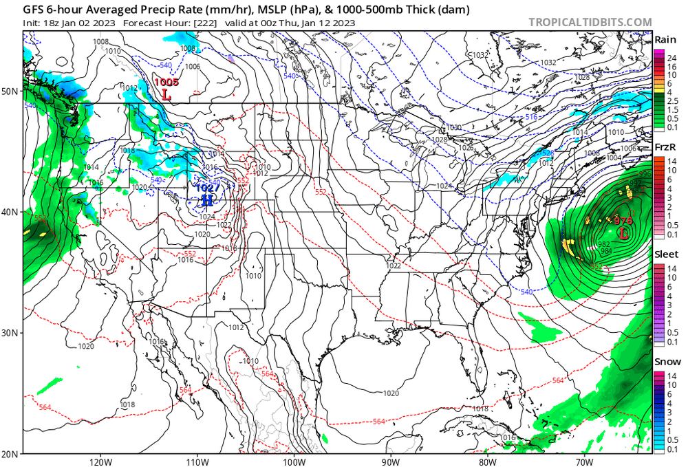
- GFS is getting happy with the N-stream ...bullying the hemisphere E of 110 W and above 40N out there. This is actually fairly typical for this guidance. Not sure how that corrects when/if it backs off on that - MJO may be less forcing given to the momentum distribution ... as modeled. However, the current behavior of the Pacific polar jet, across the Basin is rather atypical for La Nina, indicating some decoupling is likely taken(ing) place. This latter facet does lend to MJO punching through the La Nina 'firewall'. Last year something similar happened with a strong wave presentation around Phase 8 and 70..80% of the ballast was 10 S of the equator. That matters. That said, the Basin's NINO look may be receptive/entice the wave to span. What's the SOI outlook? - 12th thru the 15th are still eligible, just by numbers of respective ensemble membership. The operational version of both clusters appear to be flat outliers. No help from the teleconnectors ...as there are two events possible ( really) through the 16th, and they are sub-index mass conservation so it's going to come down to ensemble trends more so than waiting on emergence for these.
-
Day 10 ...simple
-
there are Kocin/Ucellini case studies of straight shot waves that rolled up upon hitting the EC longitude, with limited aft ridging to complete the total more typified planetary wave structure. I think folks get to hung up on idealized form ...and tend to start hand waving too soon when those features don't fit that preconception ... a lot faster than the should be,.
-
Kung Fu sucks. Dangerous sport.
-
If he’s being intubated that’s not it
-
In this post WOKE zeitgeist? - there’s no way they’d finish that game.
-
There’s a genetic condition where excessive exertion can actually cause the heart to weaken. It happens in soccer or is exposed rather more often than football American. But it strikes me in that replay like that’s what that was. But will have to get the official.
-
How do you know that detail
-
This time period we should keep an open mind about.