

Typhoon Tip
-
Posts
43,327 -
Joined
-
Last visited
Content Type
Profiles
Blogs
Forums
American Weather
Media Demo
Store
Gallery
Everything posted by Typhoon Tip
-
January 2026 regional war/obs/disco thread
Typhoon Tip replied to Baroclinic Zone's topic in New England
I just posted similar observations about that aspect re recency of the model runs a couple posts ago... I also think that the general user that is "emotionally" triggered by this engagement needs to wait on that changing... because the sooner they accept that is needed, that will go some ways toward ameliorating their angst - and improving their moods. But hey... sometimes I wonder if that's part of the fun for them. Leaving them selves open. I dunno -
January 2026 regional war/obs/disco thread
Typhoon Tip replied to Baroclinic Zone's topic in New England
and frankly, that characteristic of negative interference, in and of itself, has been the only aspect that has demonstrated solid unflappable continuity. -
January 2026 regional war/obs/disco thread
Typhoon Tip replied to Baroclinic Zone's topic in New England
I'm seeing nothing but negative interference among an anomalously fast S/W succession off the NE Pacific ... effectively preventing organized cyclogenesis either in time, or not at all, right out to the end of both this 12z GGEM and GFS operational model runs. The former goes out to D10 ... the succeeding week bears no significant change in that behavior by the GFS. Not sure what is causing it, but just observing 4 major waves passing through the +PNA trough domain in just 100 or so hours worth is an overly crowded tussle creating in-harmonic dissonance -
January 2026 regional war/obs/disco thread
Typhoon Tip replied to Baroclinic Zone's topic in New England
I was just given you shit - I knew what you meant, and actually don't really care other than hopefully succeeding in being an annoying word Karen lol -
Occasional Thoughts on Climate Change
Typhoon Tip replied to donsutherland1's topic in Climate Change
"It's as if the satellite's 'eyeglasses' got better and better over that period," says Elias Chereque. "It looks like there's more snow now than there used to be—but that's only because the satellite kept getting better 'prescriptions' for its glasses. It looked like there was more snow, but that's not what was happening." https://phys.org/news/2026-01-atmospheric-physicists-error-widely-cited.html https://www.science.org/doi/10.1126/sciadv.adv7926 -
January 2026 regional war/obs/disco thread
Typhoon Tip replied to Baroclinic Zone's topic in New England
just keep in mind that in 2015 we still hadn’t switched the pattern by this date … … which I guess you could have said that every January 11 since 2015, but we’ve been flirting with a lot of these tall positive PNA negative EPO looks with a generalized coupled minimum over Southern Canada for the end of the month -
January 2026 regional war/obs/disco thread
Typhoon Tip replied to Baroclinic Zone's topic in New England
There’s only a few weeks in a month… so basically you mean the whole month? -
Probably should change this thread's title to something like 'interest has shifted to the 18th'
-
January 2026 regional war/obs/disco thread
Typhoon Tip replied to Baroclinic Zone's topic in New England
It's a new one. the apex of winter = the nadir of snow results. -
Heh ... Euro's out to 00 hours and already you can tell it's out to f all winter weather event enthusiasts right over
-
I'm gonna go ahead and take a different approach here, Ray. I mean I'm not trying to abase what your saying ... I'm just going go with persistence. It's hard to knock it. At some point, the onus is on reality to start proving the models wrong. Which ... they may not precisely be right in how it gets done, but the principle/law of least action ( Law of least action is real in physical philosophy btw - ) has been winning too long. Anytime the models put out a solution that at least shows how nothing will happen, time to start taking them seriously.
-
ho wow man... imagine the deliciousness in schadenfreude if this ukmet run scores. and before you ask, no - it's not coming up here given everything priceless -

-
ah.. gotcha... i guess we all want what we want from the weather. personally, i do so much outdoorsy stuff from bike rides to disk golf turneys to regular golf to tennis, and boogie boarding... all of which is mitigated by excessive dps. save for the waves perhaps. i've always been partial to those evenings in the summer where the air is kinetircally charged with out the dp weight. 7 pm and there's like this metallic warmth ...the breeze is soothing. pure energy. the sun is no longer blaring down like your shoulders like a 50 lb ream of roofing shingles, and your ballz aren't default stuck to the sides.
-
can i just interject/ask? does it have to be dews? why not just warm weather.
-
m'yeah at risk of being sort of callous and insensitive to the sensibilities in the air today, i agree. it's a long slog I pot-shotted a post about 3 nights ago or whenever that was that if this next 10 days fails to produce, this winter can go f itself. ha purely irrational fun but still, it is admittedly not nice to only have cold out doors. i was thinking so yesterday. internal monologue: '4 f weeks until we exit the solar min, then march ass bangs probably with 39 while buffalo soars to 70'
-
For the moment anyway ... it seems the models are after option B
-
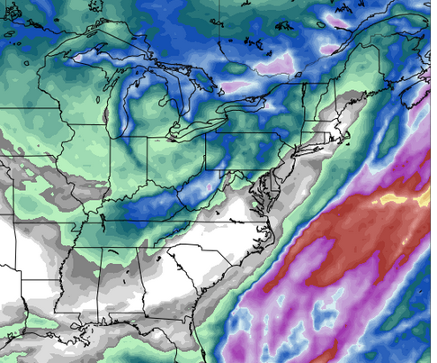
Here's the 132 hour cumulative total of ICON QPF ... LOL wow. this is awesome...
-
Of course not... but this isn't about the virtuous journey in pursuit of objective understanding in here. You kidding? You're dealing with weather drama -related dopa addicts LOL The dealer got arrested and didn't make the scene - so now your attempting to explain things to the open-mindedness of withdraw rage. Hey, more power to ya -
-
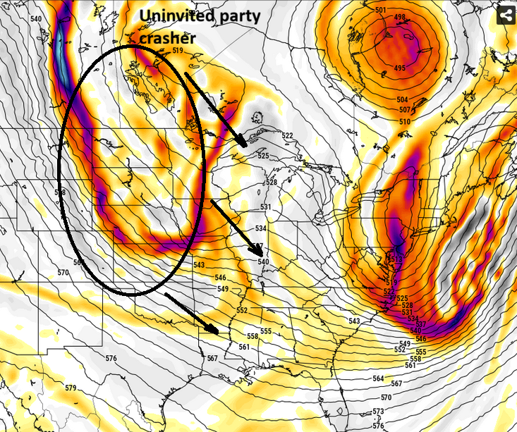
Wild guess here but, I'm betting few or no one is going to be interested in this. I'm actually curious at this point if we can hop-scotch our way through this +d(PNA) without getting anything at all like these ICON's and GGEM ideas. This thing has been plagued by this the whole way. As a snap observation, it seems even in +PNAs the fast nature of the circulation foot is crowding and not letting kinematics be conserved at small scales (cyclone) in lieu of the frenzy in the hemisphere...
-
I noticed this coincided with the relay off the Pacific into the more physically realized sounding domain out west, which began taking place over the last 30 hours ...
-
Yeah, I'm not even talking about CC... Even in 1888 we would've been cold relative to all, given the circulation mode of this two-month journey. I was just commenting that it isn't really a mystery why we are cold and dry in and of itself. The whole canvas of that? yeah, it is interestingly contrasting. Whether that is a part of GW/CC or not, that product suggests we've had it really really good as winter enthusiasts. Because it seems like nowhere else has had much of a chance at all HAHAHA. how ironic. Obviously, snow is the primary voter issue around this public arena, notwithstanding so ... sure, boned just the same.
-
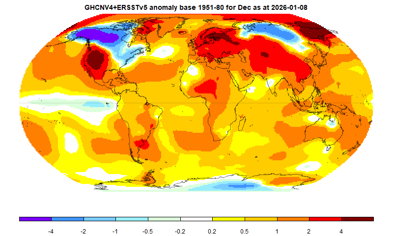
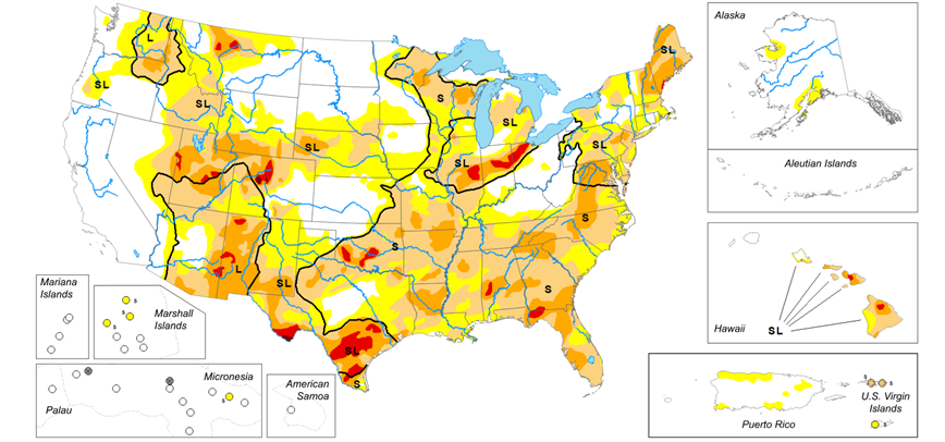
I figure you're kidding around but ..still, it doesn't incite much mystery ( it's useful to point this out to the pedestrian -) The flow is just biased in favor of some regions and not in others. That's typical 3 million years ago, today.. and tomorrow. But, we are a whopper exception to the rule according to some sourcing. Here's December according to the ERS tracking. I'm curious about Novie but ... just arm chair recall, I suspect it'd be 75% likeness or more. The early season blocking/front loading aspect serviced these cold regions and it really quite obviously got going two months ago. Bringing that back to the dry continental aspect, one of other NW flow pattern results and consequence - below being the temperatures.
-
January 2026 regional war/obs/disco thread
Typhoon Tip replied to Baroclinic Zone's topic in New England
CPC is ending up with a disagreement out there toward the 20th
-
It appears to be more than a NE region issue interesting
-
Interference is claiming both in this rendition


