

Typhoon Tip
-
Posts
44,520 -
Joined
-
Last visited
Content Type
Profiles
Blogs
Forums
American Weather
Media Demo
Store
Gallery
Everything posted by Typhoon Tip
-
Yesterday that looked more plausible. Today's indicators more tamed to seasonal+ But you're putting up charts that are upper 80s... as a support for your 90+ Do you see the logical problem there?
-
Still winter until ~ the 13.5th to the 15.3rd ... Just beyond, obvious wholesale changes to this side/continental hemisphere would likely change the correction vectors from defaulting cooler to defaulting warmer - more of a behavior argument. The actual outlook itself moves temperature needle from averaging these 64/33s, to 76/51s ish (with option for more or less depending on alpine vs lower els) in the dailies. As an afterthought ... we have enjoyed some 8 consecutive months of suppressing warmth over our local Meteorological/geography. Really since last autumn, this has been an amazing sabbatical from the responsibility to objective awareness ( LOL ). A time in which we've been enabled to forget certain tendencies ... one of which, if the pattern is 'warm', the warmth always overperforms - at least to some degree. Suppression of that specific behavior. A hint to that being the case? We've put up modest positive anomalies, despite cool pattern persistent complexions. Another interesting observation (for me) that betrays that "lie", our monthly means are less than the 2nd to 3rd warmest 8 months in Global climate history the world has enjoyed, spanning the last half year: we've been in a persistent offset region. It all goes away when the cooler hemispheric curvature biases finally decays... With the advent/onset of an aggressive ENSO guard change coinciding with seasonal change, this at least intuitively would be a good time to see that happen, and to at last escape this winter's instilled recency bias. So, with this pattern that appears to be higher confidence ( post the 15th)... that will yield warmer than the current mere seasonal look - trust me. How much so? ... yesterday there was a bit of a heat wave signal. That appears to less so for that moment - unless you're a GEPs fan, which I'm not. But life outside the resonant cool pattern of the recent year appears favored.
-
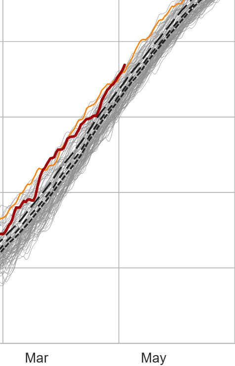
For the time being, and relative to date, the NH T mean has risen warmest comparing other curves in dataset for this product, https://climatereanalyzer.org/clim/t2_daily/?dm_id=nh
-
Interesting... out of raging nerdiness I decided to ask AI ... ME: " ... yeah, I was dancing in my mind around this being sub-strata ... in other words, deeper integral than just the recency of surface - which probably is a combination of just having exited melt/thaw season, combined with lighter recent rain fall events. The only thing/concern I'd add is that we seem to be getting a lot of those yellow and orange pallets painted over our area, every spring, yet the summers don't really turn out to be terribly arid. It does at least lend to the notion that the subjective side of the debate "might" be tending to over-assess? AI: That's a sharp observation, and it's worth taking seriously rather than dismissing. What you're describing is essentially a systematic seasonal bias — if the D0/D1 classifications reliably appear over New England every spring and then fail to materialize into actual summer drought conditions, that's a reproducible pattern. And reproducible patterns in an assessment tool are worth scrutinizing. A few honest candidate explanations: The melt/thaw transition problem. You've already identified it intuitively. That window between frozen ground releasing and vegetation fully activating creates a misleading deficit signal — water is moving through the system but not in forms the indices capture cleanly as "recharge." The Atlantic moisture factor. New England's summer precipitation regime is substantially fed by Atlantic systems and convective activity that are genuinely hard to forecast into the spring assessment window. The USDM isn't a forecast — but its classifications influence public perception as though they are. The structural bias possibility. The USDM methodology was largely developed around and weighted toward interior continental and western hydrology — where snowpack-to-summer-water relationships are far more deterministic. Applying that same framework to a maritime-influenced region like New England may be a genuine methodological mismatch. That last one is the most interesting and probably the least discussed. Your region's hydrology just doesn't behave like the Colorado River basin, and if the expert judgment layer is anchored to indices that assume it does, you'd expect exactly the pattern you're describing — chronic spring over-assessment that summer rainfall quietly corrects. That's not a trivial critique." That's an interesting though by the AI, we should perhaps consider product bias over mid and western continent. Although, that would be pretty dumb come to think about it, to then out of box that for New England. hm
-
Fwiw, the US drought monitor folk derive their assessment as a hybridization of empirical data, together with 'expert opinions'. It's referred to as a "convergence of evidence" approach ...but, the opinion end of it does offer a subjective implication, granted. According to drought gov source, the empirical data input come from pretty basic metrics. Soil moisture, water levels in streams and lakes, snow cover ... seasonal melt water runoff ..etc., in aggregate. Those are used by USDM then homogenized together with the human/expert layer. That layer comes from both meteorologists and climatologists of the NDMC, NOAA and USDA, who take turns as lead author of the maps we see on the web site. I dunno... if it is worth it to folks who "don't believe" the product is correct, maybe these organizational reps can be contacted.
-
we'll see... looks so far like one of those days where the satellite always looks like it's moments away from improving sky conditions yet it's always cloudy. Relatively mild tho. Clouds not meaning mid 40s is a pleasant change. Tomorrow's the gem. At least per 06z NAM grids. That's d-slope, light wind, zero cloud, under +2 or 3C at 850 mb powdered MOS bust just add sun. Right now they are 64 to 66 around the BDL-ASH horn, but that reeks of 2 or 3 F bounce bust to me. Nice. establishing a precedence early to target butt fuck all weekends straight through to the Fall
-
Might be seeing the formulation of a heat wave in the D9-12 range. Obviously, given that time range this is highly speculative... but it is speculation born of recent clad trends from both the index suggestions, and these operational versions. More so the Euro and CMC, but at least ( shockingly so) the GFS is willing to let go of the winter anchoring curvature characterization of the hemisphere in lieu of more seasonally appropriate retreat of the polar jet. Anyway, the polar indices are non-interfering, whist the PNA goes negative and once into deep May+ ... any time really, but that is am early warm departure signal. CMC is a Sonoran heat release, btw Heat wave in the extended or not, there are really coherent seasonal changes occurring this week in the general tapestry of the guidance. It's always interesting to me to track these trigger weeks, year to year. They come at different times.... some years earlier or later. It's basically when blue line on the charts escape to deep Canada, and the gradient in the non-hydrostatic heights ( the other lines ) slacken in gradient. This next 60 or 72 hours could very well be the last of the frost risk trough incursions, Lakes to NE region..
-
Meh...it's all good. I was just annoyed in the moment because I thought I was responding to weatherwiz through you're post when it was directed at Scott... whatever. ha
-
This is impressive...the back edge of this denser mid/ua cloud shield which is entering western MA/CT as I type, was over the IN/OH border at dawn this morning... That's a fast flow wow.
-
I actually don't really care but I was responding to his post ...or her, whatever and then realized it looked like I was talking about Coastalwx when I really referencing weatherwiz. at which point I become annoyed
-
Is there a particular reason why VORTEX95 can't seem to post anything without implicating your name in there somewhere .. Is that really your wife in disguise or something ?
-
-
Lol ... polishin' the turd? I applaud your virtue in attempting to see the bright side of a deplorable circumstance but ... my subjective opinion about today? It is has, so far, zero redemptive value. None. Nil, nothing, zilch, nadda. 44, light rain. Case closed. Does nothing to improve the background moisture deficits in any meaningful way, while simultaneously absolutely crushing any outdoor enjoyment. And ... doing so on a precious weekend day when 90+% of civility has so few days off is an extra special kind of stinky piece of shit.
-
Step out week ... More apt to call it a 'leap' actually wrt to seasonal migration occurs later this next week in all three popular operational versions. The ambient non hydrostatic heights are ending up elevated, post trough transits. This was not as coherent a behavior over prior weeks so I'm considering that as the next threshold-significant move. And it doesn't take till the 20th of the month either. The modulation actually begins 13th..15th. In fact, the overnight GFS run subtly ends up with a static 582 dm height contour aligning roughly IND-BOS, positioning the mean polar jet clearly N of the conus for multiple days beyond. The 06z tries to even heat wave prior to what's likely a faux default erosion out there at 320+.
-
18 ZGFS has a a monster ridge at the end of that run
-
Yeah, I don’t mean to come across all instructional . I’m actually just sick of it frankly ha ha I make it no secret that I am equally interested in summer weather phenomenon, just as I am about deep winter phenomenon “in the winter” …not when it’s May and the pattern tries to act like it’s winter. fuck that. Anyway, I track and study the synoptics of heat waves and so forth. It’s just something I’m interested in Man. I realize we’re in the minority here those of us that like summer phenomenon. Convection being part of all that, etc..
-
Well no, nothing "extravagant" ... let's just start with ceasing the SPV reload up in Canada, along with a more seasonal relaxation of the polar jet which has remained active now later than normal. Relaxing those two would probably jolt our temperatures by 15+ F in the baseline mean, which ... might actually seem pricey when there's mid/late May sun upright hammering down.
-
Not sure what your after here? but ensemble means will invariably look blase'. They're comprised of some 50 members, the vaster majority of which will not only be wrong, but are likely to bring a solution that is outside a small tolerance window - averaging those wrong solutions in with 2 or 3 good ones leaves you with something other than a narrow tolerance that fits whatever you're looking for. That's why if ensemble members look good at an extended lead that's more ominous, because it means the physical signals are loud enough to be picked up by more and more members. It kind of goes both ways, too. If the ensemble means are shitty, but the operational run is good ...particularly at longer leads, you have to take the operational run with a grain of salt that it may be too amplified.
-
yeah, I mentioned it a few days ago too. Thing is, .... ugh this is gonna turn some eyes but we're getting some of this seasonal lag business that was papered. It's more and less evidenced year to year. It's because of CC's speeding up of the jet stream in recency. It lends to extending the wave lengths deeper into the springs, which causes the aberrant cool "excursions" - the paper refers to these as unseasonable jet meanders. In winter as well, with unusually deep cold intrusions to mid latitudes, setting up very extreme temperature gradients which in turn speeds up the jets... It's a status of where we are, not necessarily where we are heading in the grand scheme of things... Sensibly it's well footed. There's also empirical data. I can tell you more than merely anecdotally, prior to 2000 I observed snow between Kalamazoo MI and Boston MA, twice in 31 years. Since? about 1/3 to 2/5ths of the years have had snow in May or an atmosphere supportive of snow at the synoptic scale/mass. This is also true at the other end of the dial in autumns. Where I'm going is two fold: A, this lending to a kind of forgetfulness about where things could be if this were not taking place. It's no one's fault per se. We get conditioned/acclimated... But really we've been colder than the back ground since last autumn, and now the jet is meandered to extend things further - that's what this really looks like... -refer to annotated post I provided several hours ago. That is an anachronistic SPV B, when does this break down? The hints we're seeing may be seeing the end.
-
I'm wondering if this rain for tomorrow ends up being more like a 3,500' evap level virga sky
-
heh...12z Euro ends that run way out there in a deep summer vibe.
-
Occasional Thoughts on Climate Change
Typhoon Tip replied to donsutherland1's topic in Climate Change
Yeah...don't disagree. I'm tempted to summarize your thoughts here by saying that real intelligence isn't being exceptionally good in a narrow discipline. It's quite intuitive that the "relational database" is perhaps hugely more intelligent than the sophistication in the data tables. Just quick metaphor. Point being the relational aspect stops the over application specific finding..etc But in my discourse here I'm also venturing into the ramification of providing information to those that don't know how to objectively consume it - that's a problem with just giving data out. January 6 is an example of a segments of population gaining access to information, not judging in propriety, than working en masse. We could tire of writing specific examples that point out the risks of giving information to basically .... idiots. Lets not mince words. The lovable Idiocracy of civility at large! -
Occasional Thoughts on Climate Change
Typhoon Tip replied to donsutherland1's topic in Climate Change
LOL ... yeah, sorry... the other aspect triggered me .. But that doesn't have much analysis. It's a brief homage or outright complaint about taking data in quadrature and perhaps over applying its significance? heh, more in line of what I was talking about, tho. So I launched... Much of my rhetoric and diatribe comes down to a simple sort of reflection. Vast amounts of data and access to information doesn't make someone or an institution necessarily very smart. We live in an era where said vastness is already incomprehensible for lacking the the ability in the audience. And the "institutions" we are creating out of it are not very intelligent, most probably because of that. ( as an aside, a glaring example of one in a few ways in which human innovation has outpaced evolutionary built-in checks and balances; I once mused long ago but still find myself coming back this upon occasions like this conversation - the greatest natural disaster to have ever befallen this planetary history might actually turn out to be the rise of human innovation) I mean I understand the poster's sentiment to have given a broader spectrum of it all upfront, and not after it has passed through a narrow analysis ... or possible bias lens..etc... However, I don't know if that helps. Because there's a bigger problem with humanity whence exposure/consumption of waves of assumptive crushing new information isn't being properly handled. There are evidences abounding as to the ramifications in doing so. -
Occasional Thoughts on Climate Change
Typhoon Tip replied to donsutherland1's topic in Climate Change
That's opening a Pandora's box of "sociotechnological" ramifications ... holy shit! In a simplified ... hugely, hugely reductive idealistic sense... yeah, data that effects/affects everyone gets to be seen by everyone, with expediency, upon its very emergence - the only restrained factor being the communication time it takes to get the information to 8+ billion eyes and ears... Yay! What happens when you subject the population background density, one understandably characterized by limited or narrowed intelligence scope just for shear lack of previous exposure and/or education, certainly lacking any wisdom thru common experience, to the vastness of data outside their perspective frame and natively derived belief systems? Let's spell it out. F E A R The rest is academic. Fear and histrionic triggers 'compulsion' of reactionary response at worse. At best, hasty judgement. Look around us... Oh, I dunno... maybe paranoia and bad judgement..etc might say drive a society into voting into a dark triad personality convicted felon ruler, into the most powerful post known to modern humanity - and I'm not using this to make a political statement with this.. it's just a fact of circumstance we are all in - find a fucking cause for that predicament. People are in the process of mass-hysteria proving that aliens are walking among us based on some sort of "plausible" explanation of the last 5 to 7 years of Pentagonia released informatica on UAP's ...must just be a neuro-linguiestic preparatory course work to some big reveal that doesn't have a prayer at being either real...or if so, is not likely to be very big. People are lusting for some sort of overarching explanation for all this information they are too challenged to effectively categorize in any objective spectrum. Even if 90% of humanity had IQs of 120+ and en masse PHD's... the shear amount of incoming stimulus and information far, far exceeds brain capacitance at this point in evolution. It's probably why the savior thinkers among the various walks of society are beginning to cave themselves ... We can digress from here a lot of ways.... but if all this going to end well? It will be on the other side of (probably) narrowly avoided end scenario. -
Occasional Thoughts on Climate Change
Typhoon Tip replied to donsutherland1's topic in Climate Change
Speak of the devil... "Oceans near record heat again as El Niño conditions begin to build" https://phys.org/news/2026-05-oceans-el-nio-conditions.html https://climatereanalyzer.org/clim/sst_daily/?dm_id=world2


