Typhoon Tip
-
Posts
44,520 -
Joined
-
Last visited
Content Type
Profiles
Blogs
Forums
American Weather
Media Demo
Store
Gallery
Everything posted by Typhoon Tip
-
This air mass is both colder than normal, but also... rather prone to machine/automation busts. It's just because the sun is by now seasonally hugely potent, and growing. I was just looking at Friday... that's a general light WNW to NW down slope compression look under an 850mb -2 or -3. Jeez, I've seen it be almost 60 F over a snow pack in mid February due to full sun under 0C 850s. So, although-2 or -3 is a bit of a neg anom, the surface results can be offset quite a bit when compression from air down sloping happens under all that solar power dumping into the environment. Wouldn't shock me to see those MEX numbers verify too cool
-
Not to be contrarian or argumentative but ... that just looks like background CC ( or expectation thereof ) to me. Remember, those products are not trying to equate color with the 'OMG' factor. Ha. Seriously, those are probabilities for occurrence. They don't address magnitude. For ex, if those "warm" regions were to verify +.01 for JJA, that is considered a success in claiming there was 50, 60 ...90% chance for above normal. That's it. Nothing more. I will add that this has been explained a hundred times...yet people still post those CPC outlook graphics like look out! We're red hot! These are probabilities... probabilities... probabilities..., for above normal at all... at all... at all...
-
Occasional Thoughts on Climate Change
Typhoon Tip replied to donsutherland1's topic in Climate Change
I found this to be an interesting article... https://phys.org/news/2026-04-climate-decline-hot-cold-extreme.html (https://link.springer.com/article/10.1007/s00704-026-06200-3) Dr. John R. Christy, Alabama State Climatologist (retired); professor of atmospheric and Earth science at The University of Alabama in Huntsville I'm curious if this may ever be corroborated by other's findings. **Also ... bear in mind the study is regarding "extremes" It doesn't address the longer term climate averages rising. Those are created by the daily stuffing, the vast majority of which are not extreme, per se. I can see a pathway toward reducing the "extremeness" of extreme events, while the bulk temperatures results are warming over time. It would come from increasing the water vapor content. This is basic Meteorology: in order to store more water vapor requires more energy. Raising the global energy level ( planetary energy imbalance ) by way of packing green house gases faster than the background geological processes can compensate, raises temperature. GW incarnate. This provides the necessary energy to evaporate more water and keep it in the atmosphere. I would be really keenly interested in a DP comparison variation of Dr Christy's findings, if the lowering extreme magnitudes might also have correlative relationship with any rises in integrated Dew Point (relative to sigma levels) since 1899. The idea being, as DP ambience becomes more and dense over time, it has a modulating impact on ambient temperature. This is actually rather low-bar atmospheric thermodynamics. The magnitudes of extremes of hot and cold are modulated less due to the thermodynamics involved with the energy needed to keep water in vapor form. When the ambient cold sourcing has high WV content it's just not going to be as cold, because it's holding more thermal latency. Contrasting, as the DP (temp and water vapor integral) rises the temp always comes down; that is because therms are "borrowed" from the kinetic temperature in order to keep the water in gaseous form. 98/80 has equivalent energy to 115/68 ..etc. The shortened version is a 'trade off' so to speak. Is the extremeness of extreme events trading magnitude for high WV content. -
https://www.cnn.com/2026/04/21/us/deaths-disappearances-scientists-investigation ..they've hit the Climatology community, too, if there weren't so many of them.
-
Came back 20 deg so far... 24 --> 44 Pretty much 0 discernible wind ...any movement out there is closer to untouched and unknowable. With that purity of the clear sky and now late summer sun intensity, that's about as close to a 10/10 nape factor as can be found.
-
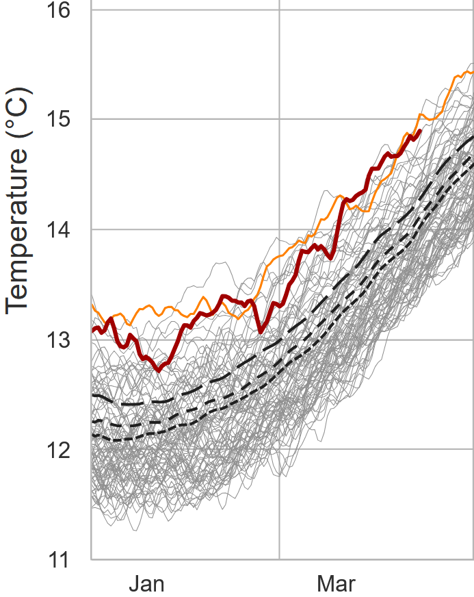
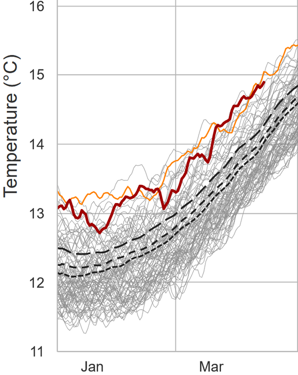
Yeah ... in so far as this, I was not intending to argue that. Ha. No I'm just changing the subject a bit that we've appeared to slip back into this bias of cooler loading into SE Canada and NE/CONUS, not dissimilar to what plagued the the winter months. I provided those monthly means ( C/O NASA) around the 10th of every succeeding new month over winter and into early spring. Every month with the possible exception of March ( though arguable...), demoed we were cooler, either relative to local climatology when not relative to the planet as a whole. That annoys me, full disclosure. For a couple of reasons. One being that I was afraid of a spring that forcibly jams cold shit down our throats and being powerless to stop it haha. I'm grappling with how much of this is "normal" though to be fair. The other reason is that CC-sociological stuff... which is a murky imperfect science of human oblivion that I'll leave alone for now. I've shown no pause or shyness in extolling my extra special hatred for April over the years, despite my love for "springing" away from winter - but therein is the problem. Seldom does this geography experience that kind of transition. I am definitely done with winter ( usually...) by February 15th every year, so let's big brother seasonal change while mother nature's not looking! Anyway, looking forward at guidance for the next ...actually out to the end of the 360s, if that really characterizes our verification we will likely be back in that cold bias region..
-
That's frost. Open fields and car tops typically begin frosting at 36, particularly on nights with high radiative proficiency.
-
Not as long; not as deep - or will be. So it appears
-
It seems about hours 72 to 96 removes the -NAO ridging in the ensemble means... but, maintains the behavior of the flow across the eastern mid latitude continent - as though it is still there. The models are "sensing" some non-linear mechanics for -NAO, powerful enough to shape the linear ( observable wave distribution ) handling whether the block is there or not. One consequence, the Euro and CMC 00z solutions. Hopefully they are wrong. Because they're attempting the dreaded rock-bottom pattern lock in using that. Particularly the CMC .. long about 156 hrs it takes tiny meso-beta scaled S/W and uses it to carve out a 3 contoured close low and when you loop it almost seems like a spontaneous manifestation with no real input. Black hole just opens up in the perfect position to impose fantastic torture. Hyperbole aside, that's that non-linearity being exposed. But it doesn't have to be right because it's beyond 120 hours. Otherwise, move to 2nd residence and don't come back until some time deep into May
-
Hard freezes in a warming world
-
It's fallen right back into that "targeted" cold anomaly that festered the entire winter ... enabling straw men deniers two sheets away from being as smart as flat Earthers.
-
Looks like there's a secondary cold front according to WPC's most recent surface analysis. Some of this might be a response to that pressure perturbation coming thru. But it is on the move... looping vis it probably doesn't last the whole daylight. Along this end of Rt 2 we're holding out with sun for the moment. Yeah, you'll get 15 minutes before sunset hahaha.
-
mm... N-E of an approximate Albany - Boston line did not register "widespread 80s and 90s" last week. Along that line did observe a couple of afternoons where it crept in but it would shunt... collapsing back into CT. By and large it was short of widespread for a large chunk of the Northeast US. Heh, I realize there is no world NE of the Tristate to Philli region, but just in deference to envious eyes made to watch warm air from their cold predicament, widespread 80s and 90s in the Northeast US is a just a wee bit of a spin.
-
Nice to be contending with this while relative to date and history we are presently "enjoying" the 2nd or 3rd warmest Earth since the invention of thermometers ...
-
Not a bad bounce back here this monring.. 44 sucks, but it was 28 at dawn. Helluva lot better. I'm sure we're hitting the bounce ceiling soon... Suppose we can keep the wind from kissing napes too much, the power of that sun, Aug 20 equiv for shits and gigs ... 101 in window shut parked car, 46 outside the window? Just imagine asking any given August 20 to be held < 50. We may start destructing by diurnal cu, too
-
After today and tomorrow the patterning looks like 10 days ( to start ...) of persistent nondescript neutral Ts... with 'tendencies' along the way for BN. It's just that typical model regression in mid spring tends to oversell cold looks in the mids and extended ranges. Then combining that bias with "some kinda" coefficient CC forcing from the background state, together probably helps to suspend closer to neutral. It's just harder to sustain below normal then it used to be decades ago. The -NAO is looking pretty weak in the operational runs... tending to limit the physical manifestation of that index state by being both inconsistent with the magnitude of actual ridging up there, but also ranging placement between the western and eastern limb. Which matters... east would allow warmer hgts to creep farther N over the mid latitude continent. I.e., maybe not as bad for warm enthusiasts here after all. West variant, however, during a flaccid slackening gradient would probably cut off lows near Cape Cod and really ratchet up the Count Rugen torture. That said, there's still something of it there. Because the behavior of transits; having trouble getting N of our latitude is -NAO suggestive. Some amount of suppression is modeled nonetheless.
-
probably trying to resolve the anachronistic circumstance of nearing solar max blazar energy dumping into meta-physically imposed January cold hell
-
well, I might otherwise be taken aback by the fact that we're going below freezing tomorrow night under a full on January thermal sounding structure ... buuuut, welcome to the biggest piece of shit geographical spring region on planet Earth - i.e., not surprising
-
And we should probably reflect in awe that a woman was involved -
-
-
We’ll probably put up a +2 or 3 April … completely somehow masking what a drab cold shit show it feels like
-
It seems like relative to every pattern ... results are + Whether it is .001 of a single degree F, or +10 Fs, +'s are sort of a baked in ( no pun intended ) consequence of being in a +d(C) where C denotes climate. But it's not just temperature? seriously...I see something subtle in the circumstances, too. Today is a perfect example. Right now, it is 69 F here... we are about to go above 70 F. Yet, looking at the satellite and WPC's surface synopsis, this appears to be a backside cyclone scenario. The strata entrails and scuddies are moving NE-SW... and there's regions of pancaking coming d-slope and evaporating as they come. Meanwhile, the main/real polar boundary is situated up in S Canada. I don't recall ever seeing cyclone mechanics closed off like this, INSIDE a warm sector. Much less... in April These are odd circumstances. These kind of idiosyncratic things... I just have an Aspergery kind of memory about weather situations since I was apparently designated by birth to waste a life with a Meteorological talent that will provide nothing for anyone ha ( I'm like the Michigan Jay Frog of weather minutia ). Anyway, I keep having to step back over this shit and go, "what in the f is happening here". Things are just behaving differently ...whether it shows up in the thermometers or not. And they're just under the radar oddities, too subtle for most to even be aware... Besides, who the fuck is complaining or getting spooked by 70 on April 17 in a "cold sector" behind a cyclone inside a warm sector ... Too nice to care. It's just unknowable to them.
-
It's like Quantum Mechanics sent particles back in time to excoriate you for your arrogant pop off, "we're going to be saying a lot of GWDLs next week."
-
Mmm... slow down there,
-
heh... just a general note on the NAO. Taken fwiw but my personal observation with -NAO(+NAO)s that are long lead signals is that they have very poor verification. We already know with safe assumption that in partial (at least) this has gotta be true, because the actual ridge node associated with the physical manifestation of the NAO block itself is being placed in different locations on every other run of the guidance. So off the bat, there's poor deterministic value there. But, even at a more orbital consideration, 'do they even happen?' ... I've come to find that a significant number of occurrences when -NAOs(+NAOs) show up in that D10 to 2-week window, they don't even exist when the whole of it is D4/5/6. They don't survive continuity coming into mid range. Out of all atmospheric indices, the NAO handling is just not well logistically managed by any one or any thing. This -NAO manifested about 5 days ago... about when it was D12. Prior to that... we were going to roll right back into a warm up. But then Monday's sharp trough and attending cold shot showed up, and it seems the models "might" have been getting a bit overzealous in creating positive anomaly NE of it as it turned the corner and rose in latitude through the Maritime of Canada. But two aspects are true and they are sort of competing. The 2nd aspect is also a personal observation, particularly in late winter into springs: when we have a warm anomalous pattern, the breakdown has in the past seemed to segue the -NAO response. It's like the warm anomaly rises in latitude and gets dumped up there...then takes 3-5 days to finally disperse... a time in which we tend to get cold shits down this way. The former aspect is more of an always consideration. The latter is a spring one. I'm trying to assess which is going to be the case. It seems at this moment, while typing, we're getting a hybrid expression between in the guidance complexions.