

Typhoon Tip
-
Posts
44,520 -
Joined
-
Last visited
Content Type
Profiles
Blogs
Forums
American Weather
Media Demo
Store
Gallery
Everything posted by Typhoon Tip
-
I frankly would prefer that to being submerged in death by the N. Atlantic. Just by personal preference, but nothing is worse - to me - than Labrador stealing time from spring and/or summer. Either way, I'm willing to bet, the 95/72 circumstance is rarer than you having the back of your balls caressed by glacial remains
-
My sympathies... yeah I'm sure as this sun continues to lase the environment we're eventually flipping the boundary layer and that'll transport momentum...ie, increase wind, and ruin it. SSE flow seems to be the layout ... rotating slowing into a SW and then WSW tomorrow. During this SSE earlier phases of that ... the cold slab of polar ocean air might meld in and force the vectors to temporarily turn back W.
-
no idea. but what significance ?
-
Still light ... Now 53, with high sun. Affect achieved.
-
Wtf was this on Dec 10
-
classic April temperature recovery ... DP ? 1 4 ...whilst it climbs toward 60 (probably). So, in fairness, splendor out of doors, considering what this loathsome time of year is capable of doing. If the wind remains light and doesn't get too wafty, then we get our 56 MOS + the typical 2 tick bust ... it will seem like a guilty bargain out there. Take this and run
-
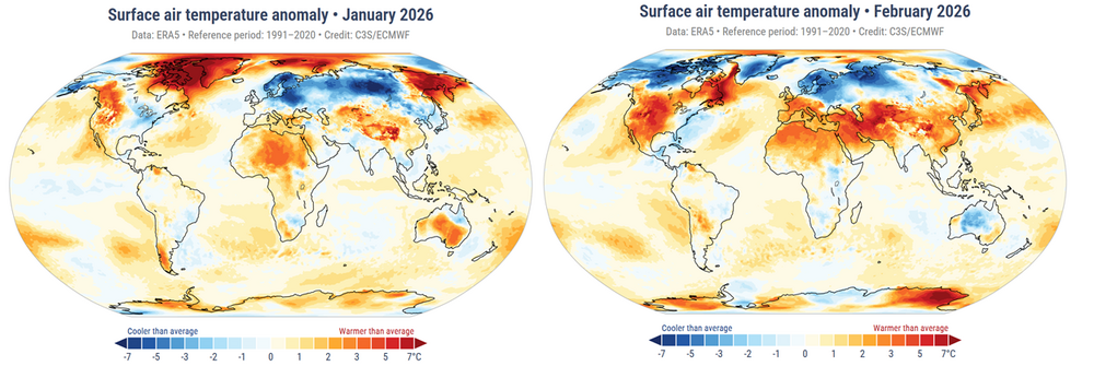
This has been an interesting first three months of 2026. So far ( date provided by Copernicus) : January 2026 was the fifth-warmest January globally. February 2025 was the fifth-warmest Februar globally. Notables so far were the variations in temperature across N/A and parts of Europe. These regions hosted the lion's share of what negative anomaly contribution there was that went into the total state of the planetary system. The graphic below illustrates these idiosyncrasies. ( I corroborated the above with NASA's releases and they conform ) March is not yet available at either Copernicus or NASA's monthly releases. NASA typically releases their finding s around the 10th of each month so we expect those soon. We know already that March 2026 was the warmest March on record across N/A mid latitude ( conterminous US), per more sources than need to really list here. Go take a look. However, again, both in data, as well as "sensibly" experienced, this was not as readily observed for the eastern mid latitude continent. Nevertheless, these eastern geographies accumulated +2 to +3 positive anomaly for the month - so ours was likely still negative relative to the whole continent, which can be ratified soon enough. This may or may not be reflected in the total graphics including the Mid Atlantic and eastern Ohio Valley and some parts of the SE. Personally, given a-priori awareness of the global circulation modes for the past 7 months and the persistence thereof, .. I suspect we'll see a repeat of relative offsets over eastern N/A and N-W Europe, while the rest of the world observes a ranking somewhere in the 3rd to 6th place for March. The beat goes on...
-
Rather than painstakingly line-itemizing everything that's taken place ... will defer to https://climate.copernicus.eu/sites/default/files/custom-uploads/GCH-2025/GCH2025-full-report.pdf ... to elucidate notables and various drill-downs. 2025 was the 3rd warmest year in general. Starting the thread for 2026 -->
-
44 .. up from 23 Probably heading for MOS+routine bust ticks. Little or no wind and now late summer solar rad will certainly max out the nape factor. Psycho babble this will put mindsets and posting vibe some distance from this morning's disgruntling bite. I'm not sure it's the last of the freeze chances (season) though, due to further below... But yeah, the models do shows some elevating thickness out there. It's just that the ambient polar boundary is still gradient packed and that's not a good look. Pattern is trying, but it is as though the models in an internal war to prevent seasonal change. That's that tongue-in-cheek vibe in the current modeling cinemas. The problem is ... it wouldn't look that way if we could just at last remove that 90/60 PV. 00z ensembles re-invigorated it, after a couple cycles whence it finally looked - after 7 months of it no less... - like it was going away. Until that succeeds, we'll keep seeing these wild temperature ranges, S-N, at mid latitude continent. We'll also suffer greater than normal BD in the means... I just recall at least 3 Mays since 2019 whence there were flurries at mid day with blown out virga cu passages, and I don't recall those years having this PV plague. Case in point, this next Wednesday. Seems with the above concepts in mind, then combining with base-line climo, there's a pretty good gamble that frontal arm ends up down near DCA with NE drill. Right now, the models are tussling with a boundary, selling a precariously float near Brain or myself latitudes. But 1030 mb and +PP N of that boundary like that? feels like a 10 year old wondering if Dad'll be mad when he gets home from work to find out he was playing with old man's gun
-
Forecasting now vs. 30 years ago
Typhoon Tip replied to EWR757's topic in Weather Forecasting and Discussion
More reliance on interpretive automation technologies. -
I like that phrase turn there ... I'd go so far as to call it Industrial tabloidism. I've mused in the past, the moment in history when greed figured out how to turn channel changing, mouse clicking, and eventually ...thumb swiping into money, that was the moment in history that civility was doomed.
-
In the midwest it's known as 'Farmer's Gold' .... late nitrogen fixing for agrarian vitality and stuff.
-
about a 10/10 nape factor. 43 F with 0 wind and high sun. Very dichotomous sensations going on...
-
you can see the snow coverage pretty fantastically here... https://weather.cod.edu/satrad/?parms=subregional-New_England-02-24-1-100-1&checked=map&colorbar=undefined
-
ha... watch, the polar boundary ends up PIT - ACK ...and we have 38 -r with one or two pellets that day
-
Yeah, 3" seems a lot. It may be enough 'in the bank' to last it out.
-
I doubt it... The continent is too dry. The flow is WSW under that polar boundary transporting a kinetically charged well mixed layer originating from the west TX high country. Good luck. If we are safely in that warm conveyor like the GFS? not much cloud. That's a red flag warning scenario there this early and prior to our own geographical green up. Even if the RH sigmas are juicier ( 800 to 300 mb levels) I'd personally lean on that being dryer verifying.
-
Yeah, I'm also at the same time a little apprehensive about going super warm at any point prior to getting that fucking piece of shit 90/60 negative anomaly scoured out of the Canadian Shield once an for all. It's not like it's very readily observable as an influence, but it is definitely an influence our our weather, nonetheless. The polar boundary with the exceptional temperature gradients we've been observing along the S periphery of the rough NP-GL-NE/MA regions is because it is up there, perpetually loading dope cold into those regions ( or attempting to); at the same time there's a CC residue/tendency to go above normal where ever and when ever the sun is working on Industrial stained atmosphere underneath it. Historic heat wave in PHX, notwithstanding. Lot of descriptive prose in there that probably lost the comprehension of about 6 return users ...with a possible 7th, but excluding those razor sharp contributors to the site brain, most people are aware of both the frequency, and rareness, of 34 to 80 across a mere 200 miles phenomenon recurring this spring so far. In addition to steepening the gradient ...it also prones our region to BDs and/or failing warm frontal positions in general. But, you know ... there are two aspects concurrently true, and are observationally competing. We are not hugely below normal in temperatures to date - in fact, +3 in March at HFD and ORH! The pattern is a colder than normal construct. That concurrent state is a nuance that I fully personally believe exposes the fact that heat is merely just suppressed, but not absent. And there is a difference there. Whopping important one, too. For one, it's confusing... but for another, it's hard to go multi-day safely in a warm sector while all this stuff is in play.
-
how much did you wind up with ? I bet with high sun shining on snow, the dry wet-bulb actually ends up being a sublimation hisser. It'll be evaporating like dry-ice man. The sun doesn't just 100% bounce off the snow... it will warm the molecules in air-contact interface, to above the DP temp and that's evaporating quickly. Like an "acid layer" eating into it. It's less like melting pack and more like going directly to gas at an accelerated rate that way. But obviously.. one wouldn't notice this if you have a ton to start
-
As an aside, today and tomorrow both should bust MOS like 1-3 F I think. It's not a huge or even noticeable thing. Not 'busts' per se. Just that we are Sep 3 sun equiv, with just about as unadulterated solar as is physically doable on this planet, with the possible exception of say 1,000 miles out amidst the Sahara ... I doubt these machine numbers have the lowest 500 feet of explosive super adiabats locked down. It's a fetish of mine to test MOS in April and May
-
I suppose if you have 6 days to know it's coming by the time it does, meh. When it comes to na na na-na scaling ( haha ), in order of irate the least is that one. 3 is knowing for days your fucked. Oh k... gradual acceptance. 2 is surprisingly BD's ... you'd think they'd be #1 but no... Usually you have some inkling that a BD is possible. Also, knowing it's BD time of year ... 1 is when it is warm for days in the charts. Plans are made. Then, the models pull the rug at that sweet 36 hours ahead deliberate look. This rendition is the most annoying. To help qualify this .. imagine a historic blizzard, not like that isolated SE Mass job last Feb... I mean interior VA to Maine, in 2-3 feet of snow, with a stall off Montauk Point across 2 cycles of Lunar tides, for 5 days of guidance. Nat Guard is on call... APs are preemptively canceling flights. General states panic as ems light up FEMA web-site graphic. General state of dopa O.D. awe --> 36 hours out that first model run with nothing. umm
-
KFIT GFSX MOS GUIDANCE 4/08/2026 0000 UTC WED 08| THU 09| FRI 10| SAT 11| SUN 12| MON 13| TUE 14| CLIMO 33 55 X/N 48| 24 59| 35 66| 44 60| 32 60| 44 70| 55 75| Heh, nothing like being 20 points above climo at both ends of the diurnal range, at 6 days lead time in a MOS product that is pretty heavily weighted toward climatology at that range ... I do think next week is kind of 'first test' for this summer - personally - because I feel this year's season has a shot at some historic heat. The reason primarily being the pan-dimensional dry antecedent continent, with lower persisting soil moisture anomalies, right as we are about to jump into the highest sun angles of the year. Keep in mind, we are less than 1 month from solar max entry... on or about May 6. We just need to shed the 90/60 polar vortex and things can turn around and catch civility off-guard. We still live in a CC-enraged synergistic heat event planetary system and that's not going away... This seems to be a good candidate year to test if we send the mercury into over-achieving warm results, both relative to pattern... but relative to "when it gets hot". Again, we need to get the patterns ...so we'll see. In the meantime, this next Tues/Wed, if that boundary does hull up NW and leaves our region soaked in WSW flow of dry kinetically charged air mass, that's an opportunity to over perform. Being 20 over climo weighting at D6 isn't trivial
-
The targeted for misery factor might be even more delicious the next day on Wednesday...
-
Brian's rage would know no bounds should this be the status at 21z this next Tuesday afternoon. Or PF! haha. Nothing like an 82, Metrowest of Boston, while it's a warm cloth to the balls 38 in N VT

-
MOS should bust cool on Thursday


