

Typhoon Tip
-
Posts
44,520 -
Joined
-
Last visited
Content Type
Profiles
Blogs
Forums
American Weather
Media Demo
Store
Gallery
Everything posted by Typhoon Tip
-
2026-2027 Super El Nino
Typhoon Tip replied to Stormchaserchuck1's topic in Weather Forecasting and Discussion
Faux -PDO's due to relative +PDO anomalies this RONI that Overall Telecon instability --> chaos/reduction in longer term predictive skill, coherent and undeniable It's a bit of a philosophical reasoning but there appears to be a realism emerging where traditional indexes are becoming gradually less usable. Ultimately perhaps meaningless as the climate air, land, sea, or combinatory thereof, proves to be steeply in delta - and it appears to be closely correlated. The greater the d(C) in time, the > the index-correlation collapse... manifested as variability that cannot be predetermined based upon known sciences. Definitely not modeling...jesus. From all that, it's getting harder, even for the harder headed types, to ignore. Stop wasting our time using them to predict seasonal modes of behavior. For none of that former starkly realistic plight lends to success being more than a blind squirrel upon a nut. We can kick and scream and get mad at the messenger here, or ... we can demonstrate a matured higher reasoning capacity that seeks truth, while being disconnected from ego. There may be more use in the permuted versions... like RONI and so forth. However, the boundaries of even those are changing. That makes them suss unfortunately. Personally I'm seeing ... perhaps "sensing" is a better word, more success in just using large hemispheric 6-monthly trends, and then getting a sense of their likeliness to continuing, or decay, based upon those total/orbital observations. It's been cold despite warm this or cold that (vice versa anomalistic result): any reason that should stop? Nope. Continue. Yup, new paradigm, break out the dice. Ha, as a wild digression ... this sort of reminds me of that new Quantum Field idea about aspects of deeper sentience at that fundamental layer where precedes the present mindful awareness, are not being constrained by time; when we have "gut feelings", those are the future transmitting backward. It's not a bad idea when matching that with anecdotal. Like someone falls off a ladder and bonks their head. As they come around they have a memory of actually finishing their descent down the latter, without it being assisted by 9.8 m/s2. There's a version of the future transmitting back, but it gets interceded along the way... I get this gut feelings that the indexes as originally conceived out of a statistic framework, won't work in the future generations - probably, this is beginning now, too. They'll be extinct eventually. -
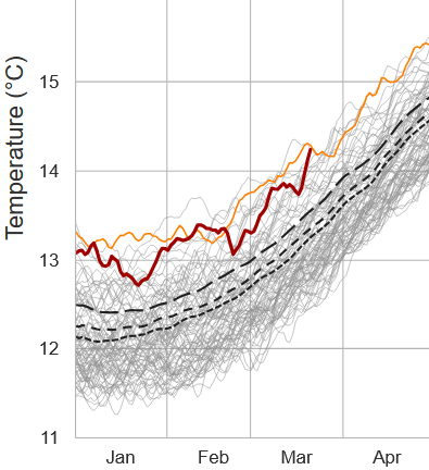
It's amazing to wonder what this global ATM 2-meter T curve would look like if SE Canada and NE's numbers were removed from the average -
-
Seems they're fighting seasonal change, huh I've seen something like this every spring around this time frankly going back years. It would be an interesting discussion to have with the modelers at NCEP...but it seems as though their physics are not integrating for steadily increasing heat input into the system. They just take whatever they see in the initialization, and then out in time they end up too cold So by the time we get to mid April the sun is like mid August. Hot as hell on sunny days. Sometime between now and 2.5 weeks .. I mean give it up. Only once or twice do I recall an air mass cold enough to offset that, way back prior to 2000 ... and these patterns in the current model depictions ain't it.
-
You can even see it doing it over the top of Kevin's house in CT... It'll probably dry out some but just sayn' a-nnoying
-
It's the na na na-na na cloud line affect
-
We're getting that standing wave cloud production that Brian was complaining about the other day, down here. It happens more frequently up there than down here, but I've seen this before... It takes a conditionally unstable layer around 800 mb running down with the flow, and as it bumps up and over the terrain there is back-building schmootz. Loop vis sat, it looks like it's emerging out of seam. And summarily, optimistic forecasts bust. great
-
You know I wonder if there's like a "green up line" I think there's something like that with trees. I could swear I've seen it, the leaf out line or something. But not sure that's the same. That pithier verdancy of spring where the fields are delicious with it like a 5-star eatery's salad .. I mean there comes a time every spring whence that is noticeable and it's not the same as a couple of fluke early warm days driving a greener patch here and there. Talkin' full commitment, and it does tend to flash over the landscape across an instra-weekly time scale - days in other words. Not sure when the first (average) time that is - I suspect that season's climate bias plays a role. It's nostalgic. I've seen pre leaf out but budding trees, with perhaps Norway maples in flower - those give off one of the best spring aromas there is outside of Lilacs. That green complexion underneath paints the fields, festooned with yellow dots from dandy lion. This setting comes on prior to the trees. Spring fever afternoon if it's 72. Four days later there's leafs cracking out
-
Yeah I like that, "...need the freeze risk behind us" I've used that in the past internal monologues while suffering yester-year doinks by the NE shit show spring climate. Don't be fooled by that random 75er like 10 days ago... they're only occuring along the space time continuum to prove there is a god, and he/she ( probably Lucy) is complete asshole.
-
I dunno about early spring around here anyway... Not speaking for back-town states everywhere, but this part of N-central MA still looks like the Middle East (forced) conflict musta went ahead and dominoed the world into a nuclear exchange. Lawns and fields are death-vomit beige. Not even the forsythia buds are swelling. nothing - It does however hurt your hands to hold onto cold steering wheels on the way to work - so ...I dunno, is that an early spring? It may look early by some scalar recognition/in isolation over who-knows-what one is using, like a few verified daily highs/low temperatures? not good enough. If so, that utterly fails in relativity to every other metric that really matters in making the distinction in a fair and objective way. Fwiw - April 1st. It's been that way in the guidance for over 10 days worth of aggregate head bang to wall persistence. The thickness tapestry alleviates "blue"/sub 540s by a bigger percentage than has been the case yet this early transition season, thus far. That combined with post March 21 and a back ground CC aspect ( that has for some reason been hell bent on being fudge packed into the SW so hard and violating that one else has a fuckin clue we are still a part of ...) may have a chance to start busting machine guidance too cold with milder times and pushing real green up. But Scott's right ... there's a probably at least a transient warm afternoon or two prior to that in the the meantime. Those are like bleeds through the dam bulge out ahead of time, hints that trigger the old timer to toke his pipe while squinting, "I reckin the change she's a-comin"
-
Why are you buckin' for that to be the case, Scott. LOL I dunno... I've seen this before in spring when the season's on the death bed. Like the "lucid interval" when out of nowhere the patient bounces back, talkative and smiling sending nurses and relatives scrambling but it ends up fake and they're dead in a couple hours anyway. Heh..just wanted to make a disturbing metaphor. No but I have seen this in spring where there's a regression, and it tends also happen during a warmer outlook, too. But the warm up comes anyway. interesting. We'll see which way this one goes
-
2026-2027 Super El Nino
Typhoon Tip replied to Stormchaserchuck1's topic in Weather Forecasting and Discussion
Something like this is happening ( or may be ) all over the planet. I'm wondering if/when the 2023 air-sea temperature burst might redux. This probably has to be verified by more than one source ( Climate Reanalyzer ) yet, but according to below it's at historic high relative to date, already. That curve it just crossed is 2024, 2023 just beneath.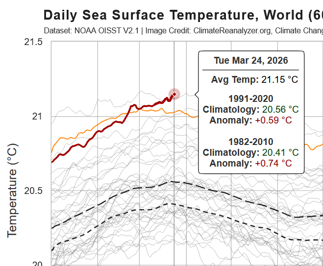
-
Yeah I've been keenly on this every day for the past month as we're globally getting set sail into this next ultimately unknown +ENSO. The warm/NINO phase is all but certain, but ...the amplitude and so forth, tbd. The last time we were in switch from a NINA to NINO, there was a global temperature surge, air and sea, like never before observed since humanity first picked up the first burning stick, wondered, and the results of that wondering ultimately dooming their fate ( whole 'nother dystopian story). It's not clear that the NINA/NINO switch was causal in the global multi-metric temperature surge in 2023; it in fact preceded the on set of the NINO. However, intuitively ...having a warm tropical anomaly concurrent certainly is not helping to offset a warming world, incrementally. This is concerning, this hot water curve above. +.58C as of that last tick ( to be verified but seldom do these not - ) is a mere .1 < than the 2024 historic max, which took place there nearing the end of April. This sets off a chain of reasoning for me... Most of those curves, in fact all of them at a glance with the exception of last year ... were already beginning to fall by now, the Ides of March. Last year, however, was the first in which that was not the case. The SSTs gained yet for another month - doing so during a NINA, no less?! The Earth had for the first time in decades, gained when the climatology inference clearly argued(s) it should have been falling. I don't believe that it trivial, albeit easily overlooked. More on that in the bottom paragraph. When looking at the recent month(s) of this year, and combining with those aspect... there's no sense there that this curve isn't going to set a new record. We are preset at an elevated state, with yet an impending warm phase of the ENSO ...? Just beginning to register, and we only have .1 to spare. It's my opinion that we are not done with the 2023 burst. I sense that was a first step during what could turn into a much more important total geological threshold/move. Last years odd global SST gains is an insidious way of signaling we are still in burst-prone' state ... Possible the same burst, but to our perception moving too slowly to notice. "Burst" in geologic time is misleading. It is going to be difficult to see to a sentience ( us ) whose perception of time moves too swiftly?
-
these new NAM numbers would have us pushing 70 on Thursday. sometimes that happens this time of year… We’re waiting in misery like it’s never going to end and then all of a sudden it’s right there and you’re like where the hell did that come from? It’ll get cold again, of course, but I think still looks like April 1 is kind of a step out date graduating to a new paradigm along a seasonal change
-
-
Still looks like April 1. Until then we’re definitely in a winter-spring hybrid pattern. The fifth season as it’s been said. I’ve had to field this text a couple of times today… ‘way does it do this every spring wah wah’
-
There's been a BN pattern that's been pretty specifically attacking N/E of the Mason Dixie line latitude. One that is unrelenting. It's really just a variation of the same aspects that brought folks cold and snows through much of the winter. However, the last three weeks lost much of the high latitude blocking - as we move through March toward April it is more and more required that there be a direct cold air feeding into a snowing scenario. Blocking was a means to supply that direct source. What's left is a BN but not BN enough without that sourcing.
-
2026-2027 Super El Nino
Typhoon Tip replied to Stormchaserchuck1's topic in Weather Forecasting and Discussion
that was snark point... it takes a super dope phat bad ass nino to actually couple. -
2026-2027 Super El Nino
Typhoon Tip replied to Stormchaserchuck1's topic in Weather Forecasting and Discussion
maybe a super nino will finally couple to the mid latitudes more convincingly. -
ugly
-
Occasional Thoughts on Climate Change
Typhoon Tip replied to donsutherland1's topic in Climate Change
https://phys.org/news/2026-03-planet.html "The amount of heat trapped by Earth reached record levels in 2025, with the consequences of such warming feared to last for thousands of years, the UN warned Monday." -
I wouldn't trust warmth ... not that you are, just sayn'. Just an example, recall that 77 F two or so weeks back. It looked an awful lot like this 12z Euro run when it was 10 days out, too. It turned out to be one day's worth. Granted, it was a ginormous one day.. The thing with heat in the latter mids/ext ranges, it is about the least dependable anomaly of all them when it comes to early lead and staying power in the guidance. I'd put the infamous D9 Euro coastal bomb ahead of a warm pattern, particularly any lasting more than just an afternoon warm sector. They just get eaten at either end. Tweak the deep layer circulation mode a little and we BD and gobble 30 hours trying to erode it out on the front side...meanwhile, CC continues to instruct a faster than normal balanced geostrophic wind velocity problem which speeds things up 24 hours by the time it gets into short range. There's 2.5 days of your warm up, gone. Maybe not exactly but it's always something around here in the spring. Having said all that, there's a verifying tendency - so far - to revert back to an SPV gyrating around between Hudson Bay and Baffin Island... that's red flag for prick tease warm patterns.
-
Oh, it sounded at the time like people were comparing dick sizes on which region was dealing with the bigger cold vs heat. I probably didn't get the gist of the conversation right - which I'm not about to scroll back and review. lol. Standard deviation would settle it among scholars
-
It’s a means to determine which region is experiencing the greatest anomaly It’s the average of the deviation from the norm, which is climatology There is no flaw on that premise
-
There's scrutinizing data and findings, then there's false-equivalency in the application of information - most that are exposed/have access, do not know what to really do with that information. We live in an era now where commoners with limited or no academic exposure to the course work are being drowned in a tsunamis of information. However... without much or no academic/juried processing, there isn't much actual intelligence (how to reason with it) in how to use it.. Information alone does not make wisdom. Reality lurks in the latter. And it sure as shit does not make one righteous. Some percentage of those using the UHI argument are deniers that look like unbearable ignoramuses whenever they attempt to ply the argument. Some percentage just heard the argument at some point along the way and now sound byte it back at us. Neither of which realizes that CC is based upon a planetary integral that predates the construction of these urban engineering meccas. While no agency of adjudicated climate research either fails understanding, nor disputes that concrete and metal tends to augment temperature... that stuff is accounted for. There is no debate.
-
Just compare the standard deviations for the cold in Alaska, versus the heat in the southwest Whichever is of greater magnitude wins the debate


