Typhoon Tip
-
Posts
44,520 -
Joined
-
Last visited
Content Type
Profiles
Blogs
Forums
American Weather
Media Demo
Store
Gallery
Everything posted by Typhoon Tip
-
Occasional Thoughts on Climate Change
Typhoon Tip replied to donsutherland1's topic in Climate Change
I also believe there's something sort of "non-Markovian" about heat waves. The short definition of what that is, in quantum mechanics, it's when past --> future states appear to fail independence. The return, or rest state of the environment, behaves as though retaining sort of residual preprogramming. It "inherits" the history of the system. Thus, returning to that previous state requires less stimulation, as though the inheritance 'inclines' the system. Heat waves are obviously above the quantum field theory scale/dimension, but... that's the underpinning philosophy for the hypothesis. Some examples, the human body. Heat stroke survivors appear to be statistically more likely to find them selves in that dire physical state again, if/when they are, again, exposed to the kind of heat that puts the body at risk. The temperature during heat waves will rise as the light rises in the predawn of successive mornings, hours prior to the sun tipping over the horizon. It's like the memory in the system somehow makes it more receptive, so much so that merely increasing lumens of the ambient air triggers the rise. I believe this is also perhaps a part of synergistic mathematics - or might be workable there. When we see these synergistic heat bursts that have taken place, world over, with increasing frequency ... it is because the initial conditions also contain heredity in the system that favors each successive attempt ( next days ). If there are no "invisible" negative interference, or worse yet, there less obvious positive interference, the results appear to go crazy. -
Meh... should be watched. It fits the collapse of the cold S motif that's been in place since October... I don't sense the hemisphere's escaped that annoyance. I mean LOL it's not annoying in January when ferreting for snow chances ... but sure as shit it is nearing the equinox and one's heart is elsewhere. Anyway, in the spirit of objectivity a blue spring snow isn't ridiculous in this pattern foot. Would like to see the EPS machinery at least better
-
Kind of reminds me of the Oct 30 2020 thing
-
50/50 ... heh, which ironically, could be the coupled variance result, but I mean just my confidence in the matter. The thing is, the global temperatures are something just shy of unnervingly close to doing something similar to what happened in 2023 - which took off prior to the actual +ENSO. That year was buried inside the global mean doing something else ... Or was it? I mean the RONI stuff sort of skews culpability in the differentials. You kind of want a non-RONI based outlook in tandem, so to make a comparison to the RONI outlook - see the difference. Digress.. Anyway, "IF" the wholesale globe bursts again, I don't feel personally as confident that a warm SST band is as forcing that way. I'm curious what this rusty curve looks like in 2 months
-
22nd's the latest, personally... I was living in a metro west amid the Dunkin' donuts, ATMs and pub crawl town of Waltham. Great memories of then.. I was in my late 20s amid random vectors of 19 year old bouncy' boobed, Brandeis and Bentley bums passing by in every direction. We used to do sets of Tennis amid, and then Mad Raven, or Joe Sent Me, or go into Boston to the Poor House ... I don't even know if those venues still exits outside the confines of fading nostalgia anymore - but I refuse to let the memories die. Oh, right... so it was 22nd of May I think. 2001 I wanna say but for some reason I mix up 2001 and 2002 events a lot. Anyway, it was 9:30am and 38 F as wind swept sheets of cat paws and occasional noodles enough to silvery glow the previous years bark mulch beds, while surely confused green daffodil shoots poked through. If you looked at the sky you could get a sense of the snow field aloft as it undulated past. Pure cold coastal ... doing all it could against climo. That was may 22nd. I'm like ... 20 days before the Solstice - really? On July 4th it was near 100 if memory serves. Went on to be a warmer than normal summer.
-
Can't say I blame the AI versions for being the cooler profiles - if I'm following the slide changes right... Looks like that. I've noticed the AI are typically leaning cooler than the operational/standard versions over the longer haul. I mean, I'm trying to figure out through exposure/inference, how these models come by their solutions. Just watching them long enough one might formulate suspicion as to what they are doing... I've already been told they do not propagate waves through a Fourier Transformation, using Navier-Stokes integrated thermodynamics haha.. Seriously though. I didn't really dig deeper when I saw that; I just sorta figured they're doing some kind of "we don't know how it works" ( a common scary seduction of AI innovation leaders - ) NBM clone and shrugged. But, I do kinda sense that it might have persistence in part of what it is doing - however in the f it is doin' it. In the absence of having actual physics determining the physical future ( eh hm..), I don't believe that AI is really trully creepy just manifesting conscious awareness about the future state of the atmosphere, and therefore am open to it really just doing some simpler shit in proper proportions.
-
my god... can you imagine the dopa priapisms in here lol
-
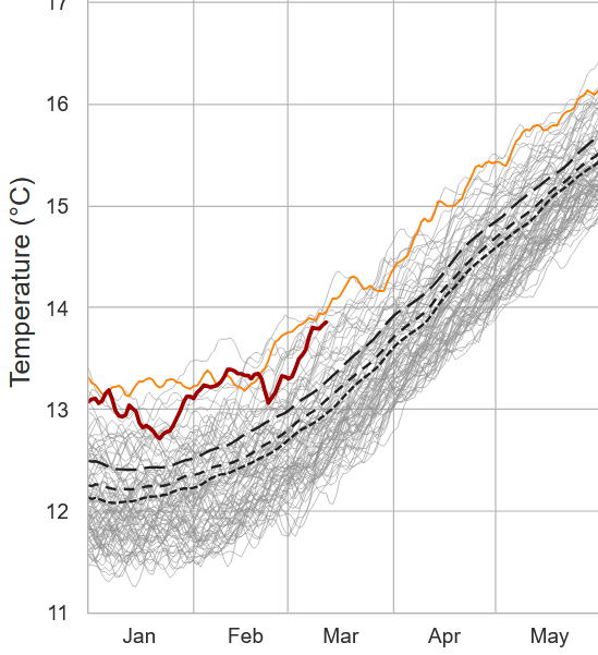
If anyone has any conceptual uncertainty/questions related to "seasonal lag" remaining, just consider that today is the same solar irradiance as September 23rd. Now imagine this below being the state of affairs on any September 23rd. Ha. - the 'absurdity value' is probably proportional to why the it can happen on March 18
-
No kidding! This is a much bigger issue ... with a spectrum of implications that transcends typical concerns with ENSO. I mean there's all the failing and fragile coupling arguments, as RONI was developed to more closely elucidate matters... but beyond that, check out the global current SSTs, only as the NINA is relaxing. The last week's-worth needs to be verified, hence the spotted line ... But seldom does that fail. It is highly likely that the global SSTs, presently, rival 2024's record breaking warmth. The astute observer might even notice that the last 10 days of which was a bit of a surge? That's coincided with this CPC product's rather abrupt break down of the E Pac cool expanse. Thus, the implications if/when NINO takes over are quite intuitive.
-
Also, as Scott - I think - mentioned.. this is the time of year when a chilly look can be flogged by daddy sun like a red headed step child, and it may not look like a mild day at first chart glance. I noticed that Sunday profile yesterday, myself. Had a kind of sneaky partly sunny with light WNW flow, and 850s only +2 ... That's the kind of day/profile that busts MOS by 3 clicks or more. It's fragile ... increase the clouds even a little and f's it all up and it's the same shit.. But at least it's non-zero some gain time of year. This bullshit enabling circumstance can fight all it wants ... June is still coming.
-
Right. I realize we put up a 75er last week ... over a snow pack, no less! But that exceptional circumstance really underscores the former point. Because in philosophic principle, the heat has to eventually punch through the pattern and then we have the unusual dichotomy. To mention, the warmth was replaced very quickly by 20F mornings. The NH has been in some kind of constructive resonance that happened to favor our region for cold. At this point, I'm hoping for a violent +ENSO mode that couples to the mid latitudes like the greatest love story of all time ...just to fuckin topple said resonance and get away from this persistence - if it takes that. Unfortunately, ENSO mode changes don't typically register in the summer when change sets in, in summer. Plus, coupling has been shaky in recent cycles. 'Sides, who wants to wait until September for summer to begin. heh.
-
You're not asking me but ... I couldn't care any less if the pattern is unremarkable, just don't be unremarkable yet remarkably persistently cold. Whether it measures in the actual temperatures or not, that has been plaguing this region of the hemisphere since October. It's as though this region's been "singled out", targeted chill. I realize we put up a 75er last week ... over a snow pack, no less! But that exceptional circumstance really underscores the former point. Because in philosophic principle, the heat has to eventually punch through the pattern and then we have the unusual dichotomy. To mention, the warmth was replaced very quickly by 20F mornings. The NH has been in some kind of constructive resonance that happened to favor our region for cold. At this point, I'm hoping for a violent +ENSO mode that couples to the mid latitudes like the greatest love story of all time ...just to fuckin topple said resonance and get away from this persistence - if it takes that.
-
Solidly below normal pattern that's masked by a solidly changing climate
-
Yeah, I was just gonna remind everyone that that is a vicious behind the shed BD raping pattern. Not a warm look for us, no way.
-
I suppose there's one upshot in this ... it's D6 - 14. I guess depictions in that range only verify if it means this lol, otherwise one might be inclined to suggest those charts don't have a prayer of being realized.
-
Yet the dailies strain endurance if one's hoping 'finished' means seasonal change. Constancy of cold toting trough succession, unending and unyieldingly preventative of any deeper penetrating and consistent spring. That's what the last several cycles of the operational GFS cinema looks like. Right out to the temporal horizons of these runs, like this 12z matter of fact, pointless blast of cold air
-
The last week's worth of the solar transition has been hidden from our Earth because of this unrelenting agenda by Earth to jam New England cold enthusiast heads in the sand. heh ... I'mmm fairly certain that come April 10, the March global temperature anomalies will again, for the 6th consecutive month, have an isolated blue node situated conveniently over denialism town squares. It's a warm sun ...for all intents and purposes, and equinoxian sun. Btw, the equinox is on the 20th this year, good for another 1.5 solar diameters-worth of sky ascent. Sun rise to sun set will soon be longer than 12 hours. I carry no secrets in the matter ... at this time of year I am all in a warm season enthusiast, so this all suits me just fine. Having offended (hopefully) with all that, I am still objective when looking and charts and data. I don't see interesting warmth, or interesting cold really through April 1. There's arguments for either, pretty much offsetting. Which means that either could lean on verification and it's not outlandish. "Bowling season" is a hypothetical three-week sorta window when packets of stronger atmospheric mechanics are at risk of being pinched off/abandoned by the increased background tendency for jets to retreat N. Give that antic a month's room to breath. We'll have to see how that goes, but in an even money spring, that averages to less snow as a base line probability, which defaults to bowling ball cut off cold pocket lows as the wild card. It seem this is best fit for all indicators and interpreting operational model tenors, for those that cannot find the courage to go on with life in the face of the type of weather that actually 97% of humanity prefers. haha.
-
Roger Smith died Really? What happened?
-
Kevin’s trying to create his own dopa hit
-
Gotta love it when the Antarctic's climo curve enters it's steepest perennial decline, yet the actual temperature's wondering off into free space ...
-
I was clear that March is a transitional month. By definition, that is not winter. It possesses qualities of both warm and cool seasons. The reasoning I gave is clad.
-
Yeah, I've never heard of March 1st climate boundaries March 21 is an 'event horizon' - impetus being, you notice nothing crossing that date. At our latitude and other geographic constraints, notwithstanding, ... March 21 doesn't mean anything to the progression of spring. You cross the equator with direct sun? jack shit. You may as well delineate the .3deg of latitude shy of the Equator that happens on the 20th and galloot about that then. If you look at our climate, March shows a defined and most obvious total -differential in both cold and snow, and.... much to the amazement of denialims, that's starting work backward into Februaries. In fact, the first day of spring should philosophically begin on Feb 10, the date the celestial mechanics imposes the escape from the solar minum into what is called the solar transition season. Yeah, March 21 ...
-
March 21 mean jack shit That date means nothing to physics and celestial mechanics.
-
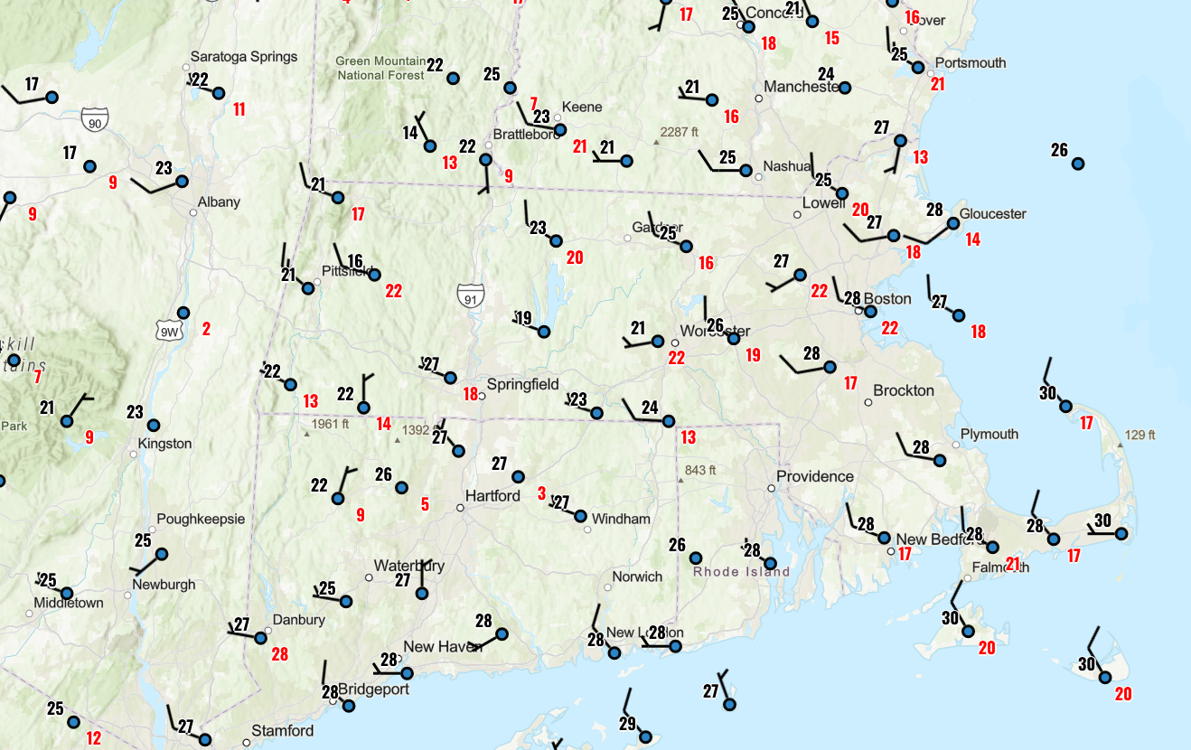
Warm fronts do this ... WPC evaluates and it seems they maybe just pick a mean position, because there's like these multiple gradient axis ... One extends along the Pike up here... It's 30s and low 40s N of that, and 50s below with more regions S obs in the wind field. Fine... but go down into the Mid Atl and there's another one, where it bounces into the mid 60s. It's like there's multiple warm boundaries in a diffused tapestry and WPC just has a snake there in the midst of it all.
-
yeah, perhaps but ... the convection in S CT seemed coincident.