

Typhoon Tip
-
Posts
44,520 -
Joined
-
Last visited
Content Type
Profiles
Blogs
Forums
American Weather
Media Demo
Store
Gallery
Everything posted by Typhoon Tip
-
looks like sun for an hour along the Pike
-
By standard non-relative ONI convention, the strength index denotes 1.5 as the cut off for "strong" As I said, the modeling ( per CPC ) presently shows a cluster mean < than 1.5 (... granted, it's rising when the graph cuts off at the end of OND, only slowly). The problem is, RONI is a very necessary method for assessing how the ENSO modes might integrate/couple with the surrounding dispersion into the mid latitude pattern. It is less integrating, due to CC, for the purpose of discussion. But it's also not absolute... it's just an assessment tool. Those ENSO modes back before ~20 years ago took place in enough of a different global environment that a more linear approach was a better predictor. This is why the Relative ONI was constructed, because as the climate change accelerates ( frankly ) all these indices are either going to get suss or are already so. Anyway, CPC model mean rises to +1.3 or +1.4 but unfortunately the outlook cuts off before we know if mid winter rises beyond 1.5 ( probably so, just based on the trajectory of the graphical mean). However, laboring to 1.5, doing so during the Relative ONI methodology arm of a very coherent CC acceleration, doesn't smack as strong or super in the end hemispheric coherence. I think there's some excitement seeking - like another crowd emergent motif. Sometimes it just hits at the right timing, and it's vastly over popularized. It may in fact go on to rise to 2.8 ...becoming something special, but I wanna know what are the mathematical/analytic reasons.
-
The modeling looks like the key 3.4 region rises to just under +1.5 toward this next Xmas. Makes sense I suppose ... El Nino is Spanish for "Christ child" and is given to the name of the phenomenon for a reason; the canonical time of year for it to occur. Anyway, 1.5 is not super this or even very strong that. Where is this extremeness coming from ?
-
could be worse ... 44 years ago today, NYC-BOS were in the later stages of an April blizzard.
-
The (not so) sci-fi version of this El Nino... It will rise to historic proportions, but ... no one saw the bigger issue coming - though in retrospect, really should have. Why? because it already happened once, in 2023. The whole planet surged, by almost .4 C spanning a 2.5 month period that spring, brining the planet perilously close to the theorized threshold of +1.5 C over the IR. Only this time ... by a whole degree C Such that not only are we at 2.5 over the Industrial Revolution entry mean, it is so crazy warm that relative ONI renders almost meaningless outside of the immediate tropical atmosphere. Vaguely coupling to the mid latitude pattern ( meaning weakly correlating) It's going to be the first panic year of this ongoing CC explosion, which just moves slower than human perception - geologically? It's detonating. 0 summer ice in 5 years. Roth slides into the ocean... Global tsunamis claims a billion lives
-
OH yeah, that's an excellent point. I keep having to also remind myself that we are not running around naked at 3:29 a.m. when it's supposedly a warm cloth Asian massage out there. Seriously... there's probably a pretty significant sensible/exposure bias involved - there has to be... we're human "animals". Completely enslaved to what we see, hear, smell, touch or taste in our defining the nature of our surrounding. It's also as least partial in why CC is so easy to collectively deny ... it just doesn't readily appeal. Not readily enough.
-
I noticed that too... Might be the last snow in air we see outside alpine regions until the mandatory, season ruining Halloween 3.7"
-
Occasional Thoughts on Climate Change
Typhoon Tip replied to donsutherland1's topic in Climate Change
These bold' are all of it. Two aspects zooming past one another in humanity's race toward the cliff. The first one is a complete and utter misconception about climate change, one that I feel pretty strongly is the fault of the origianl science PR vision. When it became clear in the atmospheric geophysical mathematics decades ago, their campaign felt like an attack on civility traditions... functional heritages ... generational ingrained ways and means. When in reality, global warming, per se, isn't the problem. Whaaaaaa ! It's not, not per se. The problem is, adaptation capacity. That's always been it, and as far as I can hear or read, very few seem to really know this. The world could warm 100 points - if all species can adapt, in time, the conversation is rendered moot. Whenever we hear these less than adequately educated self-appointed spoke persons of denial attempt to invoke the argument, "the earth has been warmer before", or "climate change is part of the Earth's history" ... we cringe. Once one understands that derivatives and partial derivatives in the integration of the whole system ( i.e., change with respect other factors ( DX/ DY) ) is what creates the nature of all and nature itself, they then know that the former talking points are just labels and scalars. Meaningless in the definition of what the problem really is. Those that continue to rely on the scalars and won't bother to get with the program, to paraphrase Brian Cox, 'you should be largely ignored ... even chastised'. Because your opinion is uncoupled from objective causality. The 2nd one is 'virtue signaling' ... At least the deniers are honest about their feelings - gotta give 'em that. Take the entire en masse acceptance demographic... of them, a scant % are actually doing anything to really curb their ways and means - they may as well be denying. I've been raging about the 5 senses evolutionary limitation on perceived threats for years. We are a species really only just on the cusp of escaping our primitive state - for the sake of discussion... call primal state any animal that is not modifying their own genetics, sending meat wagons to the moon, and on the verge of Quantum Computing ... We are smart enough to innovate these, which means ... we are also intrinsically capable of predicting how what we do will both effect and affect. Yet, we are still slaved to only believing what these intellectual gifts are telling us when we can see, hear, smell, touch, or taste the threat. I really think at a very fundamental, most discrete level ...that's it. You tell a person to step off the train track, 'a train is coming,' they pier up and down the rail in either direction - they must not believe it unless it is seen or heard. If they had, you never would have had to tell them in the first place. So, humanity is standing around on the track, arguing about the color shoes they are wearing to the engagement when it comes to this global warm stuff. Which is kind of funny, because what the hell else are the tracks for. Climate change doesn't really have a real-time observation-advocate that immediately appeals to the senses - this is a problem when attempting to convey any sense of urgency. -
I'll tell ya... the GIS montly/NASA temperature anomaly product for March might be interesting. My hunch is, like every month since October it willl have a relative min situated over mid latitude eastern continent, while it is comparatively warmer to much warmer most everywhere else. I've been posting this product on or around the 10th of the months since, showing this repeating leitmotif to hide CC from Winterwolf hahaha
-
I prefer to remain non-confrontational... heh Having said that, he did say, "March finished +4 " I'm not sure where he was looking - I could see that happening though because a theme I've been playing with in my posts is that we get modestly warmer than normal monthly means out of colder looking synoptic constructs. It's one of those obfuscating charms of CC. It makes sense. If the d(T) is always positive, that means we're on a slope, so the same synoptic conditions should register at least decimals warmer than the last incarnation. It may be a straw man argument at this point, but I do sense that people rely a bit too much on the old adage, "CC doesn't make it warm today" .... noooo, buuuut, it does mean one should expect it to be warmer than the last time. It's just another subversion thing people that know better than to deny, but can't stand the truth.
-
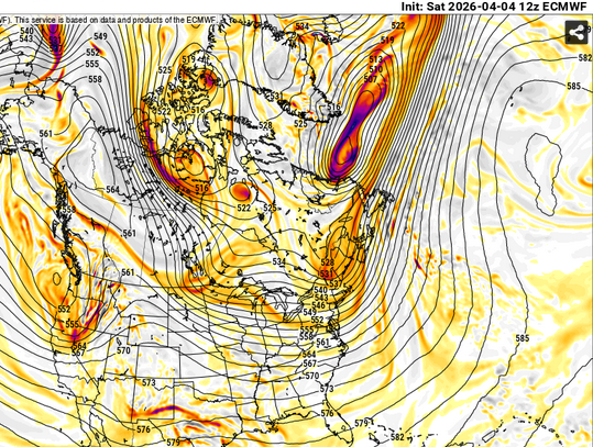
huh... Ironic. The PV's showing signs of finally shifting away from 90/60 in these ensemble means toward mid month.
-
To jbenedet's point ... the operational runs are coherently weaving a warmer tapestry out there beyond this thing. Thursday through the weekend... The cold air intrusion now thru Wednesday alleviates during Thursday. It's not going to wildly surge the other way, but 540 to 552dm hydrostats in a return WSW continental flow and ample post equinoxian sun ... will likely present modestly above normal. The next cold front after doesn't carry nearly the same bite/post cold weight as depicted.
-
I makes me wonder what the world is capable of delivering around here, if/when the pattern foot actually did flip warm.
-
Yeah, I'm just open speculating/making conjecture on the BD frequency aspect in that morning joe From a "personal" anecdotal perspective, I've observed more than is normal even for here? Relative to date that is. If we were to do the last 10 days the rest of the way, we'll have clocked 3 to 4 times the normal seasonal loading by June 1. That's a lot ha! I don't disagree about the March numbers though. I snuck in a few edits into that post ... one of which was the jest that (CC + the increasing solar)/2 is skewing matters. These latter factors are creating tension in perspectives over the years, because the patterns are cold typology but we still get nuisance warm anomalies. interesting.
-
We've had decent springs once in a while over the decades but those are more the exception to the rule. As climate and data empirically show, we more typically suffer these ~ 6-week purgatories between the end of March and early May ... give or take. Some are cold and "that one last chance to snow", along with a bit of questionable perspectives on reality hold outs ... heh, notwithstanding. For those that long for warmth and covet those visions, this year seems particularly annoying so far. What is happening(ed) is a very persistent PV, wobbling around 80..90W/60N up in Canada. So long as that is the case there is going to be an anomalous polar jet around the southern periphery. Having jet streams fixated across S and SE Canada in the means are going to create problems for us to ever warm up prior to June 15 really ... for a much longer discussion of reasons. Just in the past 6 days ...we've observed like 3 different species of BD fronts. N doors, E doors, quasi BDs whose identity lost in a normal door... We may be carrying a positive anomaly in BD even for our spring lorn region, but it's because we have a multi-month ridiculously resonant pattern more typically observed in an average January. If you took the typical January pattern foot, and mapped (CC+ SOLAR seasonal change)/2 over top, you get what we are getting.
-
I keep having to remind myself it's just the first week of April... It's just a slog, this time of year.
-
Occasional Thoughts on Climate Change
Typhoon Tip replied to donsutherland1's topic in Climate Change
Yeah, I kind of typed ahead of my thoughts there There was a “surge” between the end of February and sometime in May … most of which occurred in March, but in total it was between .3 to .4°C this may vary by source. I’ve seen the range. But yeah, that took us right to the doorway we do not know we do not want to go thru, apparently The 1.5 critical threshold. At least we’re not respecting it as a species. And that was not supposed to happen so soon. The surge of that spring close the gap at an alarming rate…outpacing predictions by global modeling and scientists by decades; at the time, it was believed it was temporary. So what’s troubling further, or should be… it has yet to go back really. We are as of right now still just about right there - but it’s obviously varies by tenths of a single degree weekly. There was conjecture in the ambit back in 2023 that it probably would settle back after a while. that has not happened. I don’t recall exactly who said it and where it came from but I do recall. Anyway, the details aren’t really that important… my objection is directed at people like that guy making declaratives, particularly ones that are preposterous like that because they don’t fit the mathematics of what’s actually happening in objective reality. -
here comes summer ...
-
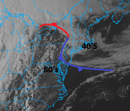
Today was much more likened to a BD than the other day... If you loop the hi res vis imagery, you can see this frontal fist punching into the upper M/A and this also jammed through here this morning,
-
Occasional Thoughts on Climate Change
Typhoon Tip replied to donsutherland1's topic in Climate Change
No confidence ... . How in the fuck could anyone take that position when the entire planetary system, all metrics, air to sea and back, UNpredictably rose a whole degree C in the spring of 2023, 0 forewarning ?! And it was not predicted by any agency, man or machine If what you are saying of his, or any other's attitudes akin to it, is true, they're all full of shit frankly. Sorry. I'm not directing this at you ...I've grown tired of hearing these idiots with a veritable podium making declarations that are so clearly arithmetically wrong, if they are frustrating they are embarrassing. NO, until something or some one comes forward as not only having predicted the 2023, "instantaneous Earth detonation degree event" would occur, but precisely and incontrovertibly how and why, logic calls their bluff. They are highly suspect if not unequivocally false. -
2026-2027 Super El Nino
Typhoon Tip replied to Stormchaserchuck1's topic in Weather Forecasting and Discussion
I guess experimentation is over... CPC adopts Relative Oceanic Niño Index (RONI) for reliable, responsive monitoring and tracking of ENSO (11 Feb 2026) -
yeah, 35 and drizzle at 7:30... now 66 here with that vague summer's aroma to the air. I'm wondering if this burst might event make the 7 - 0 It's not just diurnal. It's a warm sector that caught up to the sun by just enough time.
-
Yeah, we're likely getting east doored big time tomorrow.
-
oh, shit ... you're still hosed. sorry bro
-
64 Mostly sun but a few patches of mackerel fractals or whatever those are called here and there. Feels like deep spring. Close enough ... this completes the temp swing absurdity ... 73 the day before yesterday, 34 during the IP yesterday, now probably 67 or so today...


