Typhoon Tip
-
Posts
44,520 -
Joined
-
Last visited
Content Type
Profiles
Blogs
Forums
American Weather
Media Demo
Store
Gallery
Everything posted by Typhoon Tip
-
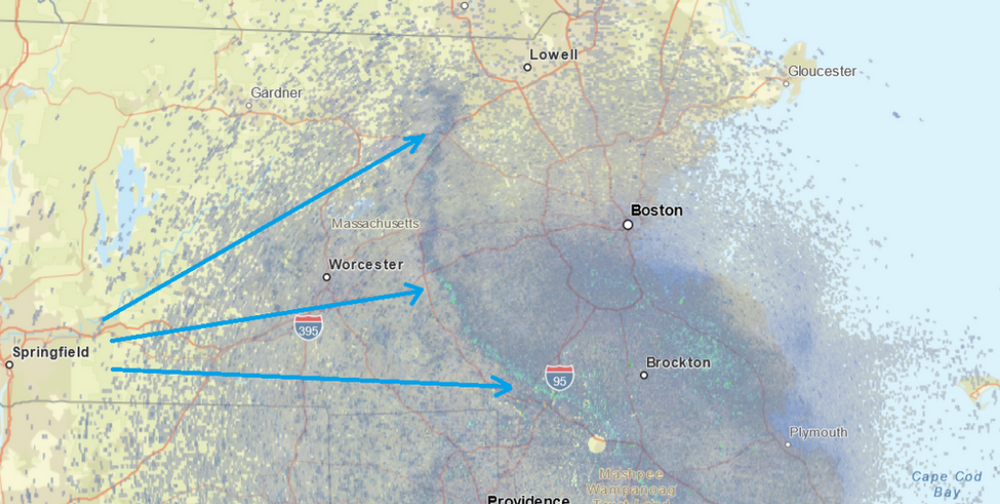
It's impressive watching the hi res visible sat loop at how fast the cloud field is moving W-E ...even the CU field, and then to have this BD thing be so wildly decouple from that blithely wobbling west through the state like that.
-
Hey Scott ...check this out. Remember we were talking about this... Same phenomenon is notable here, where the negatives are nominally compared to the positives, which have this tendency to go out of control. This is HFD on the Prelim at NWS Boston DY MAX MIN AVG DEP HDD CDD WTR SNW DPTH SPD SPD DIR MIN PSBL S-S WX SPD DR ================================================================================ 1 77 45 61 18 4 0 0.12 0.0 0 8.9 18 20 M M 9 27 340 2 45 37 41 -3 24 0 0.70 0.0 0 9.3 13 20 M M 10 1 M M 3 67 37 52 8 13 0 0.02 M 0 8.1 22 200 M M 8 1 27 190 4 70 41 56 11 9 0 0.00 0.0 0 9.6 23 100 M M 8 29 110 5 54 39 47 2 18 0 0.12 0.0 0 7.0 21 320 M M 10 1 29 340 6 51 32 42 - 3 23 0 0.00 0.0 0 11.9 25 290 M M 6 37 300 7 52 29 41 -5 24 0 T T 0 10.1 25 310 M M 6 5 36 310 8 51 24 38 -8 27 0 0.00 0.0 0 7.4 16 190 M M 1 22 200 9 57 28 43 -4 22 0 0.00 0.0 0 10.5 23 190 M M 3 33 190 10 69 36 53 6 12 0 0.00 0.0 0 11.8 23 180 M M 5 32 200 11 59 42 51 3 14 0 T 0.0 0 13.6 25 300 M M 4 35 310 12 59 31 45 -3 20 0 T 0.0 0 10.0 22 190 M M 5 30 200 13 80 45 63 15 2 0 T 0.0 0 10.9 24 240 M M 8 33 260 14 86 52 69 20 0 4 0.23 0.0 0 9.5 25 170 M M 7 13 36 180
-
Not that anyone cares but this backing boundary is through Ayer now... So far, it's been a 5-7 F knock back but it doesn't appear to be aggressive. Seeing a lot of 72's persisting E of here. Won't matter on the day's numbers. We tend to get our high for the day about now anyway. It was 82. Nothing like a +22F climo smash
-
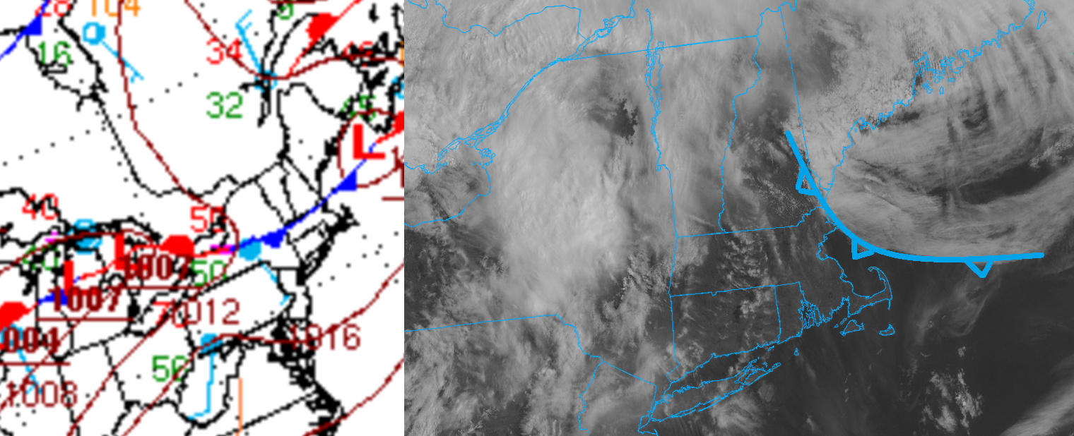
Standard meteorology misses the BD boundary types in the atmospheric spectrum of phenomenon. We just don't have a physical recognition for them. They at least say "Outflow Boundary" on the current surface synoptic charts from linear MCS' and stuff. They should at least do something about being oblivious to a monster 20 pt temp correction from something like this... Instead...they only have us safely in a warm sector, no worries... I mean, that's not trivial. It's hugely miss-informing what's actually happening to give us this,
-
Shorts and short-sleeves in full effect now... 76, almost no wind under a searing sun winning thru a smear of thinning cirrostrata and mare's tales. Even tho there is a blue balled Labradorian cold plume lurking up near Ray back porch it ooks and feels like straight up summer. I'm sure the door arrives here at some point over the next couple hours... Brain and Scott, your beloved Norways absolutely exploded overnight in town here. Since 2 days ago ...they went from vaguely discerned bud swell to full flower and even infant tiny leafs hidden inside the bouquets. Red maples are clearly flowering, too. Doesn't look so nuclear anymore. Forsythias obviously fully out. Lawns are greened and/or greening with some lengthening of grass stalk. Just saw a bumble bee hovering around in wonder - like a silent homage to a confusingly early air mass. CC does have it's moments in guilty dividends, huh ( hopefully that triggers Winterwolf and Ginxy into an entertaining back draft - )
-
PSM Apr 15, 10:55 am 54 51 92 ENE 8 0.75 Mist OVC003 1013.80 29.82 29.93 Apr 15, 9:55 am 53 51 93 E 7 1.00 Mist OVC003 1013.50 29.81 29.92 Apr 15, 8:55 am 60 59 96 N 3 2.00 Mist FEW004 BKN200 1012.10 29.77 29.88 Apr 15, 8:31 am 59 57 94 W 3 2.00 Mist FEW001 BKN200 1012.10 29.77 29.88 Apr 15, 8:14 am 59 57 94 N 0 0.50 Fog FEW001 BKN200 1011.70 29.76 29.87 You can see the BD, or whatever this backed in cold nuts shit is, in those top two rows... Temp fell back 7 F and the wind into the E. Thing is, the wind is only 8 kts after a half hour inside. Also, the sat loop shows the leading edge of the strata arc has slowed while attempting to move into Essex. These are either false indicators, or, they mean this thing isn't going to get very far SW over the mid day here. Have to now-cast which ...
-
OH f yeah. I lived in Rockport ( cold north Atlantic hiny cockport ) for year back in the day. You pretty much just assume there is no other reality but the stench of kelp and the distant wine of gull fly-bys, when there isn't the ghostly howl of hypothermic wind gust through telegraph lines. There's a couple of coffee breaks where something vaguely similar to continental summer merriment shows up from late June to early August ...along with droves of tourism... otherwise, that's a different climate driven salt culture out there, period. Ipswitch? mm... perhaps a hybrid of that but enough genetics to still look just as ugly. I guess tho - in fairness - once your stuck out there and accept it ? It kinda does have a charm. Then aspects like ocean fury and tidal challenges/Nor'easters can be fun.
-
Oh ...I see... that thrust thru the lower GOM waters nearing Essex appears to be around the backside of a weak meso-beta scale low scooting E along the stationary front. WPC at least analyzes that low below-left. Were they also analyze a standard boundary as a cfront along the VT/NH border as is illustrated. As usual, they don't acknowledge really the BD mechanics going on below-right. If the low moves east more that might terminate the momentum with that plume/BD aspect there but ... not sure how that all entangles with the main boundary. Plus the convective sewage coming out of NY is there, too

-
70 fwi temporarily w
-
really? heh. that sat image I posted looks pretty ominous... okay, we'll bide time
-
Oh yeah...that's coming ... It looks like it in this vantage https://weather.cod.edu/satrad/?parms=local-Rhode_Island-02-24-0-100-1&checked=map&colorbar=undefined
-
If that's the case we're probably doomed. Make it to noon, ... 1pm tops here in Ayer. Could be one of those days where it's 74 and dewy with sun, and then 2 hours later, jacket and slate misty sky weather. It's hard to say. Well, sore anus April climate tells us it's likely, but sometimes tho rarely ...fronts will dangle there.
-
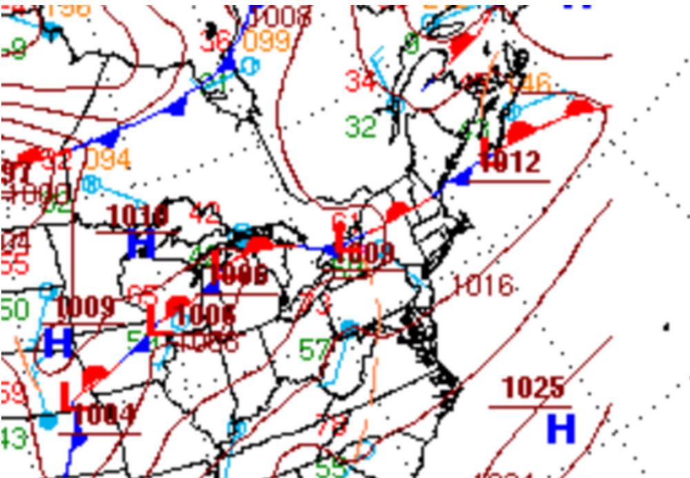
I'd like to assess where the main boundary is toward evening. We may also distill the present status quo with new convection during the daylight today ? seems humid and warming fast, with a residual plumb/outflow propagating through NYS poised to move into this warming environment. Not sure if that holds together as a trigger or continues to fan out and ultimately disappears like sometimes happens as the sun fixes the atmosphere in the morning. Anyway, right now some of those NAM solution with BD from two days ago are proven false. WPC's analysis doesn't look anything like that... not that they do a very good job charting BD fronts, but given to the regional obs layout with wind and temperatures, the fronts not moving and is situated central NE with no observable evidence of its kinking/collapsing along the Maine coast - so far. Watch that... soon as PSM goes NE at 16kts and crashes to 52 ...we're doomed. Otherwise, if we do erupt, rain cooling will probably "team up" and the whole thing repositions south. Guidance et al not likely picking up on those kind of meso nuances. If things reposition south ...elevated rise over a make-shift boundary makes elevated instability more "enlightening"
-
Occasional Thoughts on Climate Change
Typhoon Tip replied to donsutherland1's topic in Climate Change
-
Starting to wonder if this 10 days ends in a green up snow event for fuck sake
-
you went thru an interesting hour. I love that... Breeze boundary got close here and I watched as it attempted but lost against his SW breeze we got up here. Rare win ... But that boundary yo-yoed you
-
85
-
83
-
Lot of convective rains too.... Could be thundery warmth
-
Look at the ass hammerin' abuse the NAM afflicts Boston with on this 12z grid for Thur, compared to Albany and New York City... The highlight are the T1 temperature... actual SFC is typically 3 or so warmer than these. Luckily for warm enthusiasts, the wind field at Logan on Thursday is only 8kts so it's not likely moving west of the city... but jeez! OUTPUT FROM NAM 12Z APR 14 26 TTPTTR1R2R3 VVVLI PSDDFF HHT1T3T5 TTPTTR1R2R3 VVVLI PSDDFF HHT1T3T5 ALB//864549 -1800 162203 59151207 BTV//944846 00505 160304 55090706 06000576954 -2996 091917 63241608 06000798766 11400 071510 60161307 12013654356 03797 082814 64231607 12025944631 00999 073110 61151205 18000853022 -3003 122912 62161509 18002973223 -3006 143307 56050708 24000974357 01701 142402 61131509 24000964160 00006 141504 57061207 30001798361 -0196 112111 64201610 30022989263 15800 111708 59111207 36005749067 -2697 102108 66221609 36008959169 03800 102011 60161306 42119999367 03199 090701 65181509 42002997344 -0103 093304 60131007 48052926953 -1701 103106 64161409 48000986339 -1703 110103 59090907 54000717153 -0899 091502 65211408 54000907850 -1004 101503 60131006 60000627337 15997 042119 67241809 60018989567 27599 041111 63151307 BOS//742946 -0203 152811 60171308 LGA//774047 00700 163104 62191709 06000616339 -2501 121410 61211508 06000545045 -1698 132011 64241710 12000725866 02597 082123 66191811 12000535544 -1696 112418 67251911 18005762735 -3499 092718 64191510 18000716556 -0398 122911 65221811 24000802325 -2206 133607 62151610 24000764830 -1297 142408 65201710 30000727561 -2002 141211 63141408 30000596752 -2796 131910 67251811 36002897366 -3098 121612 65131710 36000505148 -3697 112216 70262013 42031989070 24698 091002 66111810 42000685853 04497 102316 69222113 48058989169 -1099 123508 64071410 48000685952 00200 112615 68211713 54001897248 -0402 120408 64081310 54000523744 -1799 092210 70261814 60000985249 03998 111008 65051611 60000422654 -2501 072218 69251913
-
73 ... might be able to add a tick or even two before the 10:05 "10 after 10" is mid 80s. The old standard ...ha.
-
yeah, why? Just curious. Trees/forestry science isn't my bag. Like at all. Complete dolt. I'm just curious what their 'pernicious' quotient is. Threatening native diversity? it seems to me they are a new members, so that increased the diversity. Unless you mean something else ...
-
I was wondering about those... Don't have any around here in town, but they should be open with those maple flowers that give off that pleasant background aroma. I love that. Norway Maples are denoted an "invasive species" but they are kind of a welcome army in book.
-
Not "right", just asking the question. But yeah, ... need to keep in mind 80 F is ahead of climo by a considerable margin. I've seen several of these since the big one, Mar 29/30/31 1998. We hovered around 90 those three days of lore. Jaw drop early heat. Prior to that... never. I never had experienced, in my life, temperatures exceeding 80F prior to May 1sts. I've lived in two regions of the country in my time: SW lower Michigan; SNE. The climate of these two regions are quite similar. Prior to the last 20 years.. cold winters, then continental sub-tropical summers, with wildly variant transition seasons in between. Both are getting "climate traumatized" in the last couple of decades...but excluding that for a moment, there are subtle differences... Namely, winters tend to be drier out there, and perhaps a modestly colder but not sensibly or even geo-physically significantly different. SNE tends to more proficient snow fall when it is actually snowing. Then of course, Michigan deals with Lake Effect activity in the winters. I left the Michigan climate behind in 1984 as an early teenager. So obviously the ballast of my climate experiences in life are SNE at this point. That said, neither region did I experience or observe 80F in Mar or Apr, prior to 1998. Since than, I've seen 80 to even 90F become "occasional" to Mar and Apr's. SO, tho it is way early ( still, with a light cough), it's happened enough for there to be some expectation to "get on with summer once winter ends". It's like we're in climate interpretive limbo
-
Occasional Thoughts on Climate Change
Typhoon Tip replied to donsutherland1's topic in Climate Change
His linear, arithmetic approach to the question is not how nature works. He doesn't appear even aware of "synergy" in the system, emergent properties of complex systems that are wholly dependent upon the interactions of products, that cannot be very coherently pre- assessed or predicted because they do not exist until they are manufactured by the system. A+B --> A' C+D --> C' ; A' + C' --> A'' where A'' is the synergistic bi-product. If we really wanna roll sleeves in how nature works, A, B, C, and D, are all partial derivatives occurring in time - it's really more like d(A)+d(B) --> A' d(C)+d(D) --> C' ; d(A') + d(C') --> A'' We've been talking about this for years at this point in here. The increased frequency of 'extra special' heat waves, Globally, surpassing all predictive tools ( sometimes by very large margins ), have already been denoted as "synergistic heat waves" in various climate publications/among the compendium of accredited sources. There's probably going to need some discrete reanalytic study, but it's much more likely that the heat in the SW U.S. during March was a phenomenon of this ilk.