Typhoon Tip
-
Posts
44,835 -
Joined
-
Last visited
Content Type
Profiles
Blogs
Forums
American Weather
Media Demo
Store
Gallery
Everything posted by Typhoon Tip
-
Yeah, but unfortunately, today’s synoptics and what’s going on next week are unrelated. there’s a collateral index exchange going on all over the hemisphere, concurrently -whatever led to today and what’s going on today is prior to any of that taking place. The impending change appears to be harmonic. The result is a Rwave nadir situated around California and that’s sending a signal over Eastern North America, which is then being augmented further by a very positive NAO -
-
Rest my case … in my own inimitable way I was describing that bold as the potential is increasing here for the dreaded “ synergistic feedback” response and this thing being a bigger deal than these 2 m temperatures. It could be one of these scenarios where if anything the GFS 2-m are behind the ball meanwhile, we’re trying to argue why the others are too hot. But this being outside of model climatology …that’s another way of suggesting a situation that transcends/the same thing as the synergistic event. Interesting test Big story for next week continues to be likelihood of dangerous heat and humidity starting Tue and peaking Wed-Fri. Ensembles are in very good agreement on building strong upper ridge over eastern U.S. through most of next week which lends increasing confidence. In fact, 500 mb heights nearing 600 dm is something rarely seen in the Northeast and is a very strong signal for record heat. This aligns with EPS and NAEFS Situational Awareness Tables which show several parameters outside of model climatology relating to temperature, signaling potential for a highly unusual event.
-
I'll have to catch up on their reasoning but this appears axial too far NW aligned to me from what I've been seeing in the guidance, as well ... a-priori with how heat of this type will tend to effect the I-95 corridor given the total manifold of synoptics. Otherwise, I think this is experimental not ready for use. But I did have a conversation with an NWS director at the conference last June, whence I brought the synergistic heat phenomenon needs to be recognized as specific risk to civility..etc. She was in complete agreement and said that heat was an aspect they were working on improving. I think this product below is a great step (example).
-
Setting up training along the western end of the Pike ?
-
Occasional Thoughts on Climate Change
Typhoon Tip replied to donsutherland1's topic in Climate Change
https://phys.org/news/2024-06-antarctic-cold-shatter-global-late.html -
I did back down in the total list or synoptic metrics, though. The GFS did too. Could be a beginning of the 'deamplification' game when extended gets into mid range. Have to watch for that.
-
so much for severe... ha! gentle garden watering rain here - run for your lives. yeah, I know there's some heavier cells embedded but there's no warnings anywhere
-
Looks like the 12z GFS peaks on Wednesday ... and then opts for a considerably different look Thursday and Friday - the consensus heretofore was maxing on the Thurs/Fri, so this run is a continuity break. We'll see... but this would a more 'seasonal heat wave'
-
We're getting onto the N side of the ridge in the GGEM ( 12z ...). This run looks prone for a MCS activity beyond D6
-
OH I see... heh, it looked like it says, 'ECMWF IFS HRES ( 10 DAYS ) from 07/29/2022 12z' and I interpreted that to be the outlook. But it was Aug 5
-
It's probably a 747 toilet bomb
-
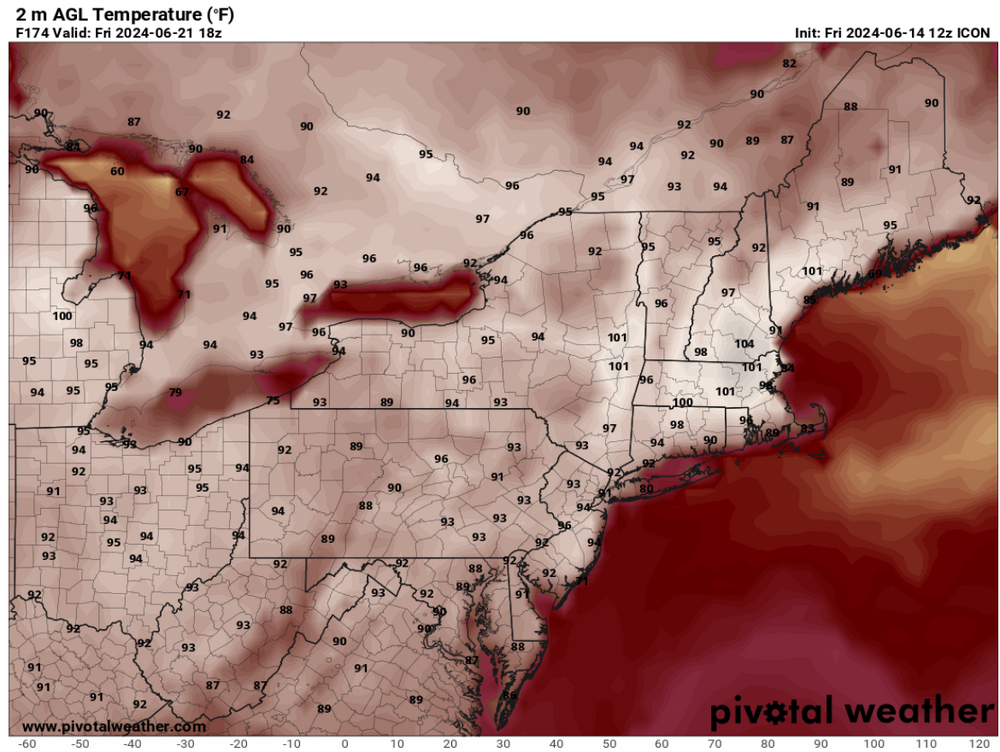
wow, this ICON run is nuts! 95 pervasive Tuesday is a cool bargain for what's in the mail the rest of the week. 99, maxing 102 on Friday... The model only runs out to 180 hours, but at 174 (18z this next Friday) there is no evidence of any kind of synoptic mechanism to diminish the heat heading into the weekend.
-
Mm ..this isn't ten days away, though. Just sayn' I get what you mean and agree in principle, but we're also getting multi guidance support now for 101's out of a D6 lead. Of course, you said "WELL into the 100s" which qualifying that remark ...hovering around 99.5 falls a bit short. heh
-
it's interesting that the highest heat lags the 500mb amplitude in the Euro. The 596+ dm is gone and it keeps getting hotter for the mid Atlantic. It relieves SNE (NE of HFD) but then again, this thing is long enough that the front of it is high confidence and the end of it is beyond the confidence horizon.
-
GFS: I was shocked to see 4 consecutive 20Z afternoon readings between Tuesday and Friday, in the 98 and 102 range between PWM to NYC. Whether we set daily records or not ... just off the top of the head I believe that would be a record in aggregation. Euro: While similar in length, it only has two days of triple digit heat, Thurs and Friday. The absolutely sick/'synergistic' heat explosion takes place in the mid Atlantic next weekend, two days, back to back with historic highs - a period of time when the GFS is attempting to dismantle the pattern. GGEM: was 91 to 95 (seasonal) heat wave implication. Similar to the GFS, it snaps the heat rather abruptly with a N-door type front. I just would advise ...the onset of this heat excursion is higher confidence wrt the pattern orientation, while just middling confidence as to actual high temperatures within... this latter aspect is too prone to nuance to be certain in best of times. A high cloud patch is the difference by 6 F when it comes to a pattern's cap temperatures being actually achieved or not. The end game is less clear. We are out there beyond 180 hours and that's the unmanned fire hose range. The GFS/GGEM could be right or wrong...
-
I’m not sure we get 97/71 without an assist in the 850 mill bar Only the euro has been willing to cast a plume exceeding 22°C… I’d like to see other models join in. Heights are high ( in fact, that may be historic in and of itself) , but we need to see the lower tropospheric parameters more convincing. That may yet be the destination … we’ll have a better handle probably starting tomorrow - 95/71 is a HI if 103 anyway. it should be noted that with heights approaching 600 dam … the the ceiling is exceptionally high. The concern should the ‘unknown length’ of the correction vector … which is pointed higher
-
Every time I check in on the next model iteration the signaled heat gets more extreme. It’s interesting that this 18z operational GFS is both increased the ridge vertical and horizontal amplitude but is actually less height (vertically) than the GEFS mean, which for the first time is closing off five 596 dam between NJ and Boston.
-
Correct … and correct.
-
I'm late on everything ( had to actually go into the office today which sucks up all my model time for traffic - ) ... but from what I saw over lunch re the last 18 hours-worth of guidance, this was still trending straight through to what I've seen so far of this 12z run cycle. The 00z EPS was just damn mean looking. The Euro operational likely has company among it's various members. The mean is over 597 ... I did get a statement in earlier re the 00z Euro's 850 mb layer being more evidenced of an actual SW Heat Release injecting into the ridge - that's the red flag for taking a seasonal heat wave and sending it... how far? There's still time to back off, but I suspect the baseline is just that... at minimum a seasonal heat wave ( 91 ... 93 )/70 ... I suspect the DPs are not handled entirely right, particularly in the Euro - unless there's been some improvement, the model tends to over mix. What's also interesting about the overmix aspect is that it doesn't really calculate a 2-meter temperature - if one looks at the sounding as it terminates into the boundary layer, it clearly stops the extrapolations at 1000mb ( or equiv sigma ) level. So one has to juggle a bit... Assume 3 F than 102 at Beford Ma become 105, which is a better match for 850 mb/23.5C, but then inject more DP... and we get 98/72 or so... Which is dangerous if things ceiling that high in this thing.
-
There it is ... in the 00z operational Euro, coherent SW heat release - not just a ballooning eastern continental height anomaly, the inject of SW expulsion in the critical 925 to 800 mb layer was absent in previous runs, but it is there now. You're looking at a 22+ C and the model even "feels" the expansion exertion by briefly closing off 600 dm heights over PA at D7. Not to be too alarmist but synoptic 101: this is not a sudden inclusion into a recent trend with the model(s). This has been a solid trend to increase the importance of this, which in the operational Euro is clearly into a dangerous heat category and is a candidate for synergistic feed-back/extending results beyond the model projections - Haven't seen the GFS yet ( LOL ) for all I know, it has a 57 F BD front up Kevin's bungus -
-
That would be hilarious though… BD at the last minute
-
The GFS is actually weaker overall in totality too with the ridge node Wouldn’t buy this run verbatim, as it’s just out of any of the models’ wheelhouse. The ens means are hemisphere anchored at this point … have been steadfast and also trending more significant up to but not including this 18 Z GEFs mean … which for some reason is late. Kinda makes me suspicious of the whole run package.
-
I'd like to see a more robust 850 mb expulsion out of the deep S/W before going too crazy. That said... the non hydrostatic layout/evolution through that period is already on par with historic events - that's got me a little spooked. This could deliver with shorter warning ... pushing a seasonal expectation for heat into that synergistic territory. It would catch civility off-guard, particularly in that .. I don't honestly believe that phenotype of heat explosion has happened here since the attribution science ( recent evolution out of necessity - ) codified them as a particular interest area. It's not tested or knowable to well over the 90th percentile population density, what over 106 would be like. We built a similar scaffold in the models in 2018 prior to the July 4 heat -that also avoided the SW/Sonoran inject. Contrasting, the July 2010 one day big heat event was not appreciably soaring non -hydrostats but the 850 layer was a Sonoran released pass through and it was 104. Are we ever going to colocate these metrics? The problem with synergistic heat is that the models will inherently (likely) fail to project them, because they are based on the super position of emergent properties. I have pretty strong conceptualization in mind that at least for us, big time stratospheric heights super-imposed by 25C Sonoran dragon fart might be a good place to start. To equate the standard deviation 2-meter T would have to be 114 at D.C. and 110 at Boston to be like London's 108 last year.
-
still a few days to go though