

Typhoon Tip
-
Posts
43,368 -
Joined
-
Last visited
Content Type
Profiles
Blogs
Forums
American Weather
Media Demo
Store
Gallery
Everything posted by Typhoon Tip
-
Occasional Thoughts on Climate Change
Typhoon Tip replied to donsutherland1's topic in Climate Change
You mean like Hansen? Not just him ... there are a lot. Many, many scientists waving their proverbial arms on street corners of the great media-sphere, warning of Armageddon. The problem isn't the scientists. The problem is whether society treats them now the same way as those disregarded raving religious loons doing the same. There's a lot of counter-cultural bias against science in general that has evolved over the last 20 years. Remember back to the early years of the "fake news" ? That was actually originally, "alternative facts" It was literally called that if anyone can recall. As though 'facts' can be in two places at once, I guess. There was (and still is) an unnervingly large number of population that actually believe(d) that made(kes) it okay to deny a given message, out of hand, if/when the message does not agree with their group or individual narratives. What they want actually becomes the truth, a fate that is sealed when they run out and find others that jive with their personal mind space - "so it must be true". I heard this phenomenon once referred to as "etho-chambers" - love that expression. Polish enough absurdities by rubbing them off enough kindred minded folk, and you can make just about anything seem real. I call it 'populist folie à deux' (folie à deux means shared psychosis). , and starts transmitting around an enable population ... enabled by industrial powered alternatives - people don't suffer consequences for their mistakes because the former advantages supply too many recourses. So any truth is now negotiable. And not all of this is like walking coolly around these messengers of science. There are those that risk being met with actual vitriol if not violent threats - in a "reality" where violence acts without restraint has become relatively common place, no less. Considering scientists by trade: it's not hard to imagine their apprehension in that realm. The idea of leaping out in front with any kind of message that doesn't jive with the zeitgeist. Most of them are not hailing from a realm of patent wealth and are yet to make their big splash...etc...etc, with lives they're trying to support. No need to elaborate further. But despite this...there are those up on the stage behind the chicken wire. -
guys... don't fight it - this is a chilly week in the large synoptic sense of it. Let it happen and go by .. Beyond D5 the whole tapestry for the hemisphere is milder to warm at times. The only thing will be an enhanced BD risk, a bit higher than climo given to all that curved flow type between here in Greenland. We really need a more zonal flow through the Maritime of Canada. Cross those bridges but D6 to 10 may have a couple days of AN over night times that are notably milder.
-
one the more impressive forsythia bloom years I can recall in quite a long time. Dense displays with vivid pop. And it's not just one or two yards... it's everywhere between Ayer and Auburn in Middlesex arguing for something 'pheno-responsive'
-
Is it my mistake ( Tam' ? ) or isn't it early for even Norways? Obviously they're the most eager every spring but I think they are also more variable of all big stem species and can be triggered by a season's 'climate personality.' My sister was telling me that Norways are actually invasive to N/A. Either way, their florets give off a subtle sweet aroma that for me sparks a lot of nostalgia for some reason - ... I just can't remember her name or if she ever existed. LOL.
-
Norway maples exploding open all over town. It actually first started two days ago… Mark on the calendar, April 18.
-
yeah this too... Although, I do recall a fair number of mornings with car top frost. Lot of them actually, so who knows. I mean then we gotta get into valleys vs highlands. Some of these dead still mornings with car top frost are like 35 F here in the Nashoba Valley ( to use my location for example - ) but ORH was 40 at the time. In fact, while we're at it... I have a pet peeve about all the SNE "climate" sites. The only one that I use really is HFD... because for 90% of us or more it is the only physical-geographically relevant location there is out of all 3. ORH is 1,000" high. BOS is out on a island in N. f'um Atlantic's Labrador devil's blood head waters. While PVD is too prone to ocean taint as well... Any kind of climate feed coming from these sites is dubious and I also feel skew records if/when incorporating them into ongoing effort and assessment. This is probably arguable among other sites across N/A and the world... but we have 3 annoyingly dubious ones in our own AFD back yard.
-
Every time I read these drive by statements about an AN month, during a month that clearly "feels" cool I wonder about CC acclimation skewing perceptions. Not being above that myself, this month simply feels like a cold p.o.s. to me - which based on what I just said, may and probably is not entirely fair. LOL. I think I have a personal bullshit bias I'm stuck with that we're supposed to be getting these Mar/Apr crazy warm episodes now, based in no small part on the fact that 7 out of the last 10 years have hosted early bud pushin' orchard killin' false expectation inducin' warm bursts. Perhaps this year we are getting to the same AN result, just doing so along a more aggregated, yet tamer SD dailies ? Some of those years that had the weird 80 days really early, also put down a cold week with heavy snow later on, too. More spiky perhaps...
-
yeah... GFS and Euro even more divorced re the D6-10 range
-
Occasional Thoughts on Climate Change
Typhoon Tip replied to donsutherland1's topic in Climate Change
I see that. Yeah, it'd be difficult to parse that out given that part of the world. This is their 'hot season,' under near upright sun angle. Like in the Pacific Northwest in June 2021 ... comparing model output to verification/climatology is an easier distinction. But it was historically hot in the Sahel nonetheless. -
00z Euro (operational) threw out the bathwater on the cold p.o.s. useless pattern. heh The GGEM also tossed. These models are both parting company with the GFS, which is holding onto the idea of plunking a -2.5 SD micro nuke at 500 mb down over NE at D6/7... It's doing it over a seasonally neutered baroclinic ambient lower troposphere, though ...so all we get from that is a paltry 1002 mb surface response and bunch of grapply/pea hail low top convection below the summit snows up N. The GFS has cold/amplitude bias beyond D 5..6..7 -ish. All troughs, closed or open, are consummately deeper than every other guidance in and beyond that time range in every run of the GFS, always () . There are certainly times when deeper verified(s) better, and the GFS looks pretty good. But every time? I doubt it. It's one aspect about the GFS I noticed around 2013 or so and has persisted since. It tends to accumulate colder heights over the polar side of the best perceived latitude of the main jet. Such that by the time a D10 roles around - when it doesn't matter LOL - it looks like the PV/arctic domain is in a state of regressing global warming... (sarcasm). It's actually relatively subtle, and not the same amount. But some 6 to 10 dm deeper in the nadirs of 500 mb across the hemisphere, relative to all other guidance, is too commonly observed for comfort. That subtle deeper depth concomitantly increases the ambient gradient, which leads to increased basal flow rate of the polar jet. I suspect this is why we get so many top heavy ridges in spring in the GFS, where it looks at 500 mb like a big warm up is coming, but the GFS ends up with a 1045 mb high over western Ontario, directing an E wind everywhere. The faster consequential flow velocity meant that confluence ended up too strong --> bigger high. Warmth excludes from the surface. The GFS has trouble getting SW lower troposphere flows under raising 500 mb to concurrently happen out in time. The model is uniquely adept at hiding warm up potentials, right at time of year when that it preferential to do so - nice!
-
I was also wondering about the ejecta heights in that question of his, too. 70 K feet is really barely punching through the tropopause over the equatorial latitudes. The altitude being ~ 60K ... but the termination into the stratosphere is obviously more the 10 K. That might matter. S02 in the troposphere where turbulent mixing and H20 interaction/reactions ..etc, disperses a local volcanic event to where it probably barely shows up as a blip in the total global PP(unit-v) within short months. Get an inject into the stratosphere though - different ball game.
-
Occasional Thoughts on Climate Change
Typhoon Tip replied to donsutherland1's topic in Climate Change
Ha, ... was just reading about that. Also ( imho ) likely an example of the 'synergistic heat wave,' a type of heat burst phenomenon that exceeds leading indicators - but I did not admittedly read that stated. If the so-called Weather Attribution Group's study contains that verbiage then credit - I've haven't read the entire report. Anyway, synergistic heat bursts are increasing in frequency, and they are a different animal than merely recognizing a ridge of warm air in the models out in time and assessing three days 90+. -
actually ... 3 or 4 days may be spinning that, too. The ensembles, all three sources, really don't lift that formulating cold pattern out of the eastern continent until after D10! We'll just have to hope the models are - as usual - shorting the solar/seasonal forcing, whereby they end up over amplified out in time. There is some possibility this corrects toward something less extreme.
-
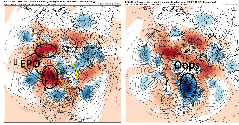
It's a race... Folks are unaware/don't care/... tired of looking and don't wanna consider, pick a negligence, but the -EPO taking place this week was a strong telecon signal dating back some 10 days. We aren't likely getting out of that without some sort of cold profiled synoptic torment - how much so/amplitude TBD. Could mean anything from a mere 3 or 4 days of glancing BL air with frosty mornings, to setting the table for a snow event event whether the dailies of the runs even show that at this time.
-
Spring won't be complete until we've significantly muted the orchard crop for a 3rd straight year ...
-
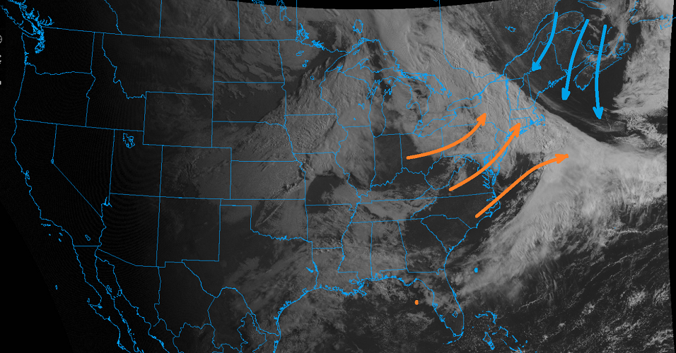
Knew this was going to happen when looking at those charts a couple of days ago. Three days of sun just has to mean three days of fecal skies and cold air. There's a convergence axis in the larger circulation medium, the axis of which is stalled right over New England. You gotta loop your hi res larger scale imagery to get a feel for how this ain't goin' nowhere quickly It's not well enough that we get to just have a fair time of it - there's apparently a butt -bang budget that afflicts this region. Any sunny day in April is not allowed to just be a sunny day ... there has to be this misery 100% tax in the other direction. Lol. Remarkable how accurately and precisely the models all were in depicting this circumstance above from week out in time - go wonder!
-
It'll go 7 games because of the two 0Ts the B's lost to make that happen ...after giving up the tying goal with 30 sec left in regulation, too -
-
This is very interesting https://phys.org/news/2024-04-scientists-paradox-extreme-cold-events.html I've mused a possible sci fi novel idea in the past where "Gaia," it turns out, has an an ethereal consciousness; it's just so vast it eludes what we think of as awareness - ... perhaps 'godlike'. And, it is well-aware of CC, more importantly, how to "cure" the disease. I like the analogy of the Clean setting on an oven - you know... raise the temperature to kiln degrees and converts the organics to ash. The impetus here is of course to clean the disease causing agent. But that's kind of hard to do if the pathogen is aware of the temperature rise. Uh... humans are the intended ash to complete this metaphor. By sending cold cloaks into the continents ... think of the frog in the pan experiment: plunk a frog into a pan of boiling water and it immediately jumps out ( or tries to...). But turn the heat up slowly and the frog, continuously adapting, will do so until it is cooked alive. That's all tongue-in-cheek, but it's an eerie negative feedback loop whence the primary inducing differential CC agent only responds immediately to that which is directly perceivable through the five senses ... which is precisely needed, and is being offset.
-
Nice ... much milder 12z GFS run. Much more in line with the ensemble mean's mass field distribution out in time so perhaps giving this type of solution some credence. It has a flat ridge in a -PNAP continental flow structure, with a wavy boundary from roughly IA to ME in the extended -
-
It's an annoying look for spring/warmth enthusiasts. We'll have to keep scraping by with 'fake' warm days at best, and may have some chilly ones mixed in ... until 7 to 10 days from now. I doubt any of those cold profiled events the GFS' native bias to disregard seasonal forcing and run back to February it always does at this time of year, have much of any hope of actually materializing. Rarely so, the April 1987 and May 1977's can happen. But given the stochastic nature of spring modeling season in general ...those are more typically last minute detected. In a cooler hemisphere in spring, the GFS will be the first in line to offer up 6:2 snow at 20" fantasies.
-
Wrong ... Kevin already proclaimed spring 2023 was warm and dewy everywhere - ...I think he should know. god
-
Look at this incredible warm up on the 12z Euro ..
-
All we have to do is reverse the last 3 decades of accelerated global warming ...thus, returning the total manifold of base circulation tendencies to the previous paradigm ... The "Japan marine heat wave" will go ahead and disperse should be easy to do
-
we'll be fretting around with nape -like days ... some mild, but a few cooler than normal through D7 but we really need to get on the other side of this, which is pretty well agreed upon by every modeling convention there is, telecon to operational version. After 6 or 7 days from now, this has rapidly moderated to a general nominal dispersion of neg and pos anomalies ... by then being late April/sun it's like the final escape out of this abysmal cold season at that time - that's probably be modestly AN. In fact, there's even to modest suggestion emerging that a mirror departure may formulate very late this month - but heh ...extended range in April is about as dependable as a lotto ticket so we'll see.
-
Temps approaching the mid 80s on the 29th no less... ha


