

Typhoon Tip
-
Posts
43,368 -
Joined
-
Last visited
Content Type
Profiles
Blogs
Forums
American Weather
Media Demo
Store
Gallery
Everything posted by Typhoon Tip
-
I only remember once in my life forecasted back door front never showed up. I was amazed.
-
Every year one of these BDs on the charts gets successfully beatin back from all these plausible philosophies and interpretations and then what happens? it ends up in southern NJ remarkable correlation exists between those two results … General rule: if the models hint at a back door cold front at all, it will be misery beyond NYC some 90% of times. maybe this will be the one in 10 time it doesn’t
-
-
In fact, that has a BD boundary into NE massivetwoshits.
-
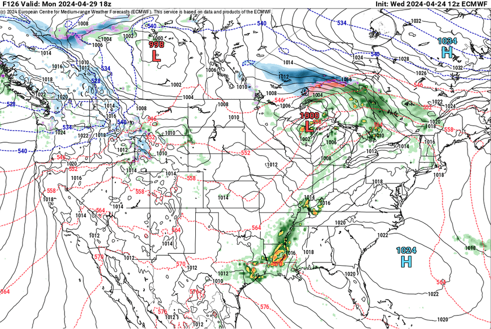
"Less likely" isn't an entirely responsible statement for our climatology in late April, when then also considering it against the actual modeled tapestry for that period of time - not sure you are fully aware of either of these two facets. lol j/k but we've seen BDs materialize out of less leading indicators a thousand times. Wiz' is right - there's already something in that look that is hard to pin point what's going with that. Here's the Euro's 12z ... not willing to bet against a BD with that giant polar high up there like that. It may work out. hope it does... just saying, "be leery".
-
just had a non-severe micro burst here. Dark skies and sprinkles and out of nowhere... wild whipping around pine trees and loud white nose. Sun back out and much less
-
Some of the other guidance have been on and off with a pretty significant BD early Monday so... just be leery, tis the time of year - The flow over eastern Canada/Maritime isn't ideal for heat here - as is modeled... It's tending to curved field orientation. We want that zonal or we risk the NE fisting
-
That might make sense ...both locations are a bit displaced from the equatorial regions where the tropopause heights are naturally lower.
-
Occasional Thoughts on Climate Change
Typhoon Tip replied to donsutherland1's topic in Climate Change
imagine the power that could be generated if turbines were forced by tides... wouldn't have to worry about whether the wind is blowing or the sun is shining... celestial mechanics --> tide cycle is always on, period. -
Occasional Thoughts on Climate Change
Typhoon Tip replied to donsutherland1's topic in Climate Change
moderate shower here... -
early warm air seldom occurs with elevated ("summery") DPs. That's not only statistically true, the reasons are academic -
-
Winter 2023-2024
Typhoon Tip replied to Stormchaserchuck1's topic in Weather Forecasting and Discussion
Every month next winter is likelier than not to be above normal across mid latitude N/A - it's a matter of how much or little. -
GFS up to it's usual unique talent to wall off warmth from getting N next week... That huge ridge at mid and upper levels .. yet it somehow engineers the means to keep a cool E flow from ORD to Boston
-
We should also also qualify the contest. Ha! I mean this is the 'solar forcing' contest. Yeah, I've witnessed more. I actually saw a 54 F spread in January 1994. It was a +9 F at dawn; 63 F that evening at 9pm with southerly whole gales leanin' tree tops and plumes of steam rollin' off of snow banks. Different beast. These spring diurnal wars between Earth and sun are interesting for a excruciating dweeb like myself; the Earth's will to keep it miserably cold at this time of year, gets its ass thoroughly tanned by a boarding school nun sun.
-
Prohibitive favorite for top diurnal spread today... Bottomed out at 29 around 5:50 am just before the dimmer switch started elevating the light. It is onw 56 already. A 27 F correction thru 9:40 am. 850 mb Ts mature to +3 by 21z ... I doubt the mixing hgt gets that tall but we'll see. The sun is pretty ferocious now and sat and sky truth are both diamond clear with 0 inclusions. So the super adiabatic layer at the bottom will be violently bouncing against the ceiling. It may be a late high ... between 4 and 5 pm. Was visualizing about 67 at BDL and FIT and I'll be damned if MAV machine numbers are right there. But assuming so ... 38 or 39 spread at a time of year where a 1 to 2 pt machine cool bias is not unheard of ...we could cap out at 40 degree spread. wow Sneaky pick of the week day. I mentioned that today had a chance to be a gem but I think we're all too captivated by the size of the seasonal dong we're about to take Thursday to at least enjoy a swell day in the foreground ?
-
It's because Dandruff isn't soluble in water -
-
Okay put it this way... whatever version of winter one is suffering or celebrating, notwithstanding ... that season persists. Lol But again ...I suspect there's a pretty clear switch sweeping across the continent later this week. Friday transitions. Saturday big high moves ESE of the area ... and heights rise modestly positive while 850 deeper cold rapidly retreats into higher latitude Canada. Sunday and Monday solidly AN with overnight lows this time also staying above average. Either a proper front or a BD perhaps after that doesn't have the same annoying shade temps
-
half the days in an average January, if you placed April 22 sun over head would also be 54 F - it's winter still. sorry... Like I said this morning, we're not out of the gravity well yet
-
Occasional Thoughts on Climate Change
Typhoon Tip replied to donsutherland1's topic in Climate Change
Guys ...there's a pollution thread -
https://www.cnn.com/interactive/2024/04/climate/plastic-pollution-ocean-cnnphotos/
-
Anyone west of a I95 tomorrow ( Tues ) may have a sneaky run at 70. 850s pop to +3 C between 18z and 00z, with general ceiling level RH < 50% not three weeks before entry into solar max time of year ... the MOS and man expectations will definitely hold the temperatures down too much - how much so, notwithstanding. But +3 at 850, if the mixing depth gets that high, is 64 at the sfc - then the "tree height" slope at the bottom of the sounding is easily 70. Unfortunately ... from Scott to PVD to metrowest to N. Shore probably get caressed by Labrador urine
-
Changes coming. The modeling horizon glows with the distant twilight. ...Having just said that about 32, a real shot at this week being the last of that crap given to the multi-sourced modeled tapestry beyond this Friday. No promises of course, but that's a definitive complexion shift over the whole hemisphere. Happens every year going in either direction ... the levee of the old finally caves into seasonal forcing and there's a series of days when the modeling represent that by flushing the system
-
Thick frost here ... 32 on the button. Haven't truly escape the gravity of this last winter until this shit stops. I don't care where the temperatures have been thus far -
-
Occasional Thoughts on Climate Change
Typhoon Tip replied to donsutherland1's topic in Climate Change
Imho, the large paradox is that human evolution is evolving it's de-evolution. -
12z Euro got the memo... ... what a blue bird special both weekend days. 2-meter Ts on the raw model are about 7 to 10 cooler than what they'll likely really be given those total synoptic metrics. Figure near 70 Sat and in the 70s on Sunday, with light wind and 90+ % of possible sun.


