

Typhoon Tip
-
Posts
41,643 -
Joined
-
Last visited
Content Type
Profiles
Blogs
Forums
American Weather
Media Demo
Store
Gallery
Everything posted by Typhoon Tip
-
It'll be disappointing ... that's the forecast for winter. this overall social media's real purpose is to serve as a support group for folks that have a weird kind of emotional regulation issue vs being "dosed" by big model depictions. annnnd like the last 10 years of pounding lessons yet zero apparent retention ... next winter will succeed in giving plenty of reasons to make the aa meetings on time. haha, stick to forecasting the dosage amplitude - you'll all be seasonal heroes
-
I could see this becoming an anvil/mammata late afternoon from southern VT/W CT, with distant ominous thunder that devolves to just occasional orange lightning and a period of moderate decay rains. Nasty mosquito evoking weather where it's warm and sultry with lighter rain might be the biggest disaster that befalls western zones out of this when that claims the late day for them. You should probably plan to chase to see that yay
-
On the contrary... it's typical to dawn murky high dps with a patchwork of fog and low strata on severe days. This is in fact expected behavior. There are sunny/skylights stationary E of the topography; this is keyed into high DP air mingling with shallow nocturnal inversion resulting basically in very low level 'steam'. It's not even 8 am and no sooner the sun tips over treetops and there's rapid evap ongoing. Not just typical, it's physically obvious why this is the case, too. Our biggest limitation on the day most likely will be timing. This may evolve more across central NY/PA along that axis, with a few descrete/dangerous cells then organizing into linear segments. The better instability will be there extending down into the M/A. There's not a lot of CIN in these areas. Oriographic assisted cu features will probably take off without restraint and quickly. This does not include areas E of Albany initially. The whole synopsis doesn't bring the front through here until 2+am overnight so that E NE may not be in the party at all. May get some activity into western zones as the typical accelerating outflows organize/pool and propagates down wind and triggers/cyclic development. There may also be a prefrontal trough ... there's so little inhibition in this whole set up, that could trigger and rob down in the eastern PA/PHL/NJ area. SPC's got it pretty well covered.
-
Occasional Thoughts on Climate Change
Typhoon Tip replied to donsutherland1's topic in Climate Change
https://phys.org/news/2025-06-climate-bright-red-scientists.html -
southern Lakes/SNE teleconnector in full effect for tomorrow... 24 lag on the button as that one goes. Always look to Kalamazoo - in principle. I mean there's a monster squall/linear complex in the area with a smattering of super cells out ahead of it.
-
Well ... ha, they'll miss whether the damn things 'll form. They tend to turn right of the environmental steering, because they are in fact drawn toward the better CAPE, and that's likelier S, where the cold pooling off the ongoing convection has organized into a meso or meso-beta scaled convectively induced cold front. This lifts the environment, and the static stable layer over the top is forced to ascend to where it is no longer static, and that kicks off the redevelopment cycles there ..hence the propagation. The model physics handle that in principle. The GFS is in fact turning right ... the Euro and GGEM are driving it E through Maine. At this range, either is possible. The amount of turning right probably has some other factorization.
-
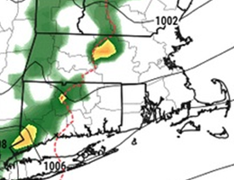
if you look at this loop, literally over just the last 1/2 hour or so, all of NE PA/E NY, W MA and W CT just went more sun than clouds. My guess is the warm front is mixing out. It's 76/70 here up from 73/66 and hour ago, and though we're in the clouds its noticeably jumped.
-
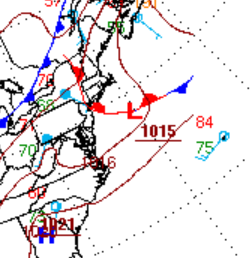
you actually beat us ... Why you sumna bish ... Yeah, judging by this cut out of WPC's "always" trustworthy never odd looking computer generated frontal tapestry ... ( haha) that we're getting the old end-around warm frontal passage - it's likely through you guys up there and we're getting quasi nut pinched down here.
-
Well ... what do you mean by that - the models are tracking where they see it. How do we know where that axis will be at this time. In principle, that's true. They'll pac-man along the elevated thermodynamic gradient.
-
All the models have the MCS now... interesting. Euro most aggressive
-
Actually... the GFS/Euro offer opportunities to roll bigger heat right back in - I think these 12z runs above all else underscore the need to NOT take operational runs very seriously outside of 6 days. This whole heat thing begins On Monday... but the end half of it is way the hell out there in that region of changeability - fwiw, monster derecho on the Euro through upstate NY and NNE mid weekend. This may need to be watched imho. If it's there, it's just as liable to turn right and end up here in verification. *if* it's there. The model's even got a convective lamphoony low up there with that sucker
-
12z operationals appeared to inch back hotter at least in the Mon-Tue aspect... Just going by the 500 mb cinemas. altho I did see the GGEM; waits until Thursday mid day to BD and it's not a very strong signal either.
-
Yeah, all that ...and, I'm personally suspect that these global model '2-meter temp' depictions are not in fact the actual 2-meter temperatures, but are really just stopping the adiabats at 1000 mb level and taking whatever it calculates at that sigma level. Pretty sure they lack the resolution in that lowest 20 someodd mb of the floor ... where the 2-meter slope temperature really is. It can be 95 at the top of downtown church steeples and 101 on the sidewalk going by.... Although, in the winter, they do better ... but then in the winter the sounding is pretty uniform ( typically..) in the lower 100mb
-
"Worse"ter yet ... he'll be standing out there glaring enviously at a brightly lit bum side of the CB tower as though the cool kids are mooning him. lol
-
The ensemble means all look better than these operational versions regarding the pattern/favorable delivery The operational versions have been subtly increasing a polar jet curving through SE Canada/N Ontario... cutting it real close. It's tough to bring big numbers into NE with that synoptic construct - invariably we run into +PP genesis over Ontario itself and that's the ball game. we'll see
-
12z NAM buckin' for a 1953 redux - even gotta hook there
-
heh.. never was aware that was a requirement - i'll take a look
-
Why am I getting this "1 file would exceed the total allowed size of 21,xxx KB" notification when others are posting images that clearly exceed this number ??
-
Yeah... I'm kind of Doctor J vs Mr Hyde when comes to heat. I'm utterly fascinated by the "big heat" synoptics, just like I am for big winter events. I don't like to live in them. SO ...admittedly. That said, it is not like rooting them on, tho. I believe I'm morally okay with it, because as a science curiosity, that's where my interest in them is. I'm not like Kevin, who roots on the dystopian horror of people cooking in the streets from the confines of his well-A.C.ed, model interpretive "boudoir". They have particular identities. Especially in these recent eras of the ongoing CC/attribution stuff, when they are occurring with greater frequency all over the world, and are dangerous ... ( more deaths than all other weather event types combined), there's definitely value in learning how to use the guidance. etc etc.
-
Perhaps you are unclear on the concept of "not based upon all present indicators ... "
-
This is not a correct assessment based upon all present indicators ... it's okay bro. It's only mid June. We'll have other shots at this over the next 6 to 8 weeks ( before the GFS routines begins snowing at D10 in mid August LOL )
-
Yeah so others are onto it ... no heat wave next week. Pattern is sputtering to 2 days on, 2 days off... and no confidence there after for next weekend. The 2 days off could end up being dramatic too... We've gone from 101's in guidance to 68s over eastern NE.. The problem is up over eastern Canada. From what I can tell, whether or not heat can expand and amplify for something more than merely pedestrian AN is sensitive to what is happening up there. The flow has been sneakily correcting deeper and deeper with that anachronistic SPV SW of the D-Straight... The Euro at this point has a strong polar jet now curving around underneath - heat in New England seldom succeeds with polar jets in that position. The idea of a +PP emerging and crushing the fragile heat S is really academic at this point. The only way to reverse all that is to have that SPV substantially weaken in the guidance. So, this may have been just another extended red herring ... no harm no foul. We've spoken about the confidence risks already. Plenty of time and this is all acceptable adjusting at this range. I will say, the ensemble means are still flatter with the flow up there, however - so ...it's not impossible that the operational versions are a bit too amplified with that circulation structuring up there. We'll have to see.
-
I still would watch for a mid weekend MCS it seems there’s a noncommittal warm frontogenesis on the leading edge of the arriving torch synoptics. An eruption along then turning SE out of lower Ontario is climo favored and the operational models already can’t seem to resist - could be a severe risk for derecho followed by a heat burst pattern. Somewhat rare sequence for our region.
-
Getting the crud’s mid week like this is a switch. Perhaps this is related to the larger changes in the hemisphere that will also roast next week … It may also signify breaking the cycle of timing Saturdays for shits
-
what's the trigger tomorrow? it's CAPEy no doubt but I thought the wfront shifts N of the region and we're just sort of neutral in the pigs bum


