Harry Perry
-
Posts
1,173 -
Joined
-
Last visited
Content Type
Profiles
Blogs
Forums
American Weather
Media Demo
Store
Gallery
Everything posted by Harry Perry
-

Pre-Christmas (Dec 21-23rd) Winter Storm
Harry Perry replied to Chicago Storm's topic in Lakes/Ohio Valley
Bonus on the GFS, shows a decent clipper on the heals of the departing system. Starts Sunday evening and drops a few more inches across southern Minnesota, most of Iowa, northern Illinois, Indiana. Brings more moisture and lift into the DGZ for the LES belts - even with the disturbance passing south of the lakes, enough to squeeze another 1-3” for western lower Michigan, maybe more. Still a long way off. -
Pre-Christmas (Dec 21-23rd) Winter Storm
Harry Perry replied to Chicago Storm's topic in Lakes/Ohio Valley
Yeah, should make a thick crust of ice/slush beneath. Travel will be a nightmare. Nice hearing from you, been a minute. -
Pre-Christmas (Dec 21-23rd) Winter Storm
Harry Perry replied to Chicago Storm's topic in Lakes/Ohio Valley
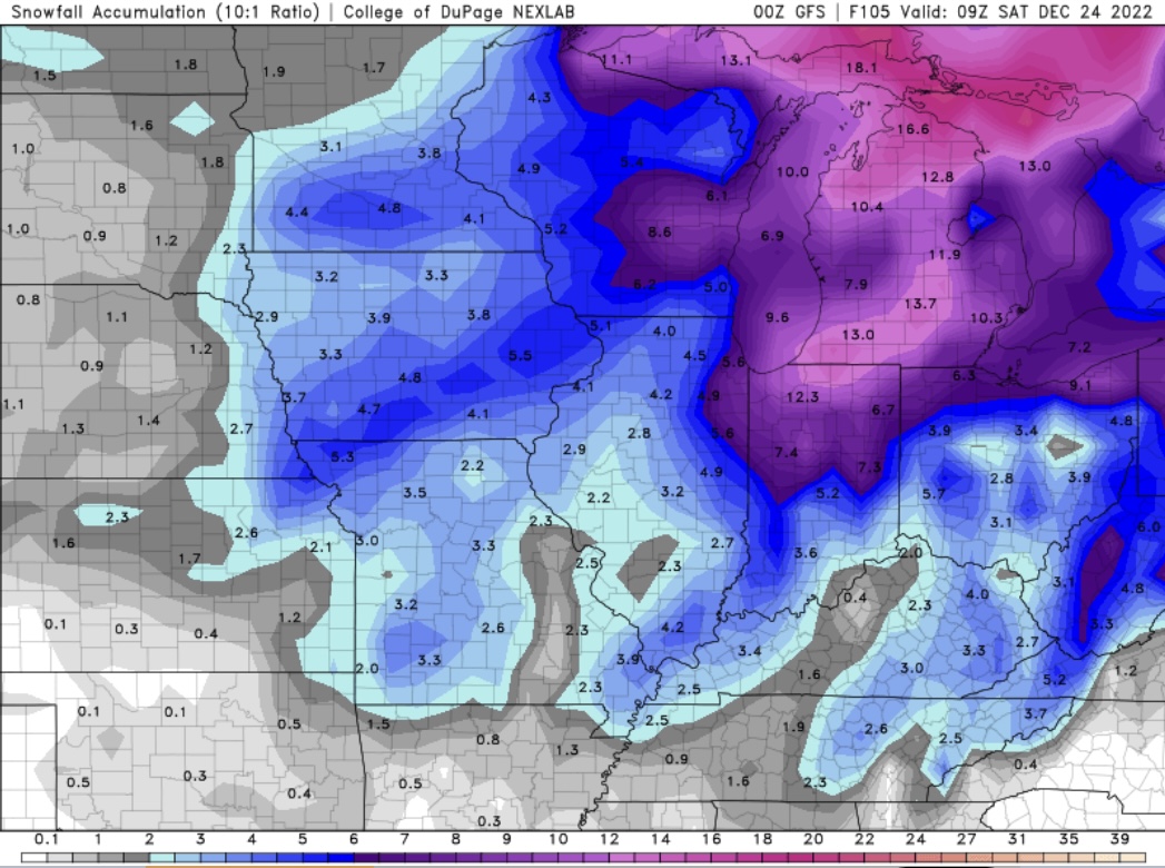
More realistic, though ratios are cut due to high winds shredding the flakes.. 10:1 still snowing.
-
Pre-Christmas (Dec 21-23rd) Winter Storm
Harry Perry replied to Chicago Storm's topic in Lakes/Ohio Valley
For the weenies…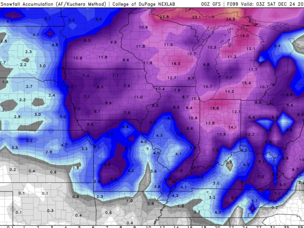
-
Pre-Christmas (Dec 21-23rd) Winter Storm
Harry Perry replied to Chicago Storm's topic in Lakes/Ohio Valley

-
Pre-Christmas (Dec 21-23rd) Winter Storm
Harry Perry replied to Chicago Storm's topic in Lakes/Ohio Valley
Definitely a wound up storm but getting weaker on QPF every run. -
Pre-Christmas (Dec 21-23rd) Winter Storm
Harry Perry replied to Chicago Storm's topic in Lakes/Ohio Valley
With storms of this magnitude, we’re going to see wild fluctuations 96+ hours out. You don’t want to be in the bullseye at the moment. One thing is pretty certain, it’s going to be a massive system. -
Pre-Christmas (Dec 21-23rd) Winter Storm
Harry Perry replied to Chicago Storm's topic in Lakes/Ohio Valley
Wagons west. -
2022 Short/Medium Range Severe Weather Discussion
Harry Perry replied to Chicago Storm's topic in Lakes/Ohio Valley
Really need to get some instability over here.. still socked in with thick low-level clouds. 14z HRRR out to lunch on current convection. 15z has it but doesn’t look to handle it all. -
Didn’t rain here last night, but with strong southerly flow the modified air has settled in here. Dew points were briefly in the upper 50’s this morning, but have only slightly increased to 63° imby at the moment with a stern 15-20mph southerly wind. 18z guidance not handling the surface moisture at all. Plumes all showing 70-74° surface dpoints at the current hour. SB instability obviously not materializing as expected across southern lower Michigan so that’s probably why the slight makes that turn SE, betting that the strongest storms ride that gradient further south and most convection will weaken quickly this side of the lake tonight.
-
Had nothing to 45kft tops develop overhead and drop about 10-15 close CG’s.. moved south now we’re getting no rain, but a constant loud rumble and lots of intracloud lightning. Didn’t expect that to materialize, wondering if more will develop and ride the gradient SE. Seeing some development mid lake at the moment.
-
2022 Short/Medium Range Severe Weather Discussion
Harry Perry replied to Chicago Storm's topic in Lakes/Ohio Valley
Same. Had one rumbler about a month ago. Outside of that, nothing. -
2022 Short/Medium Range Severe Weather Discussion
Harry Perry replied to Chicago Storm's topic in Lakes/Ohio Valley
Yes, thanks OHweather for the discussion and analysis. Great information. Will definitely be interesting to watch everything evolve tonight/tomorrow. -
2022 Short/Medium Range Severe Weather Discussion
Harry Perry replied to Chicago Storm's topic in Lakes/Ohio Valley
00z HRRR backed off on the squall threat locally. Shows one round of isolated storms around 8pm and another round firing up along the warm front riding southeast (training) around midnight. -
2022 Short/Medium Range Severe Weather Discussion
Harry Perry replied to Chicago Storm's topic in Lakes/Ohio Valley
This kinda smells of 5/29/2011.. nasty derecho followed by 90’s with no power. -
2022 Short/Medium Range Severe Weather Discussion
Harry Perry replied to Chicago Storm's topic in Lakes/Ohio Valley
Should make for an interesting afternoon. -
2022 Short/Medium Range Severe Weather Discussion
Harry Perry replied to Chicago Storm's topic in Lakes/Ohio Valley
Tomorrow afternoon/evening trying to sneak up on us. RAP/NAM show some intriguing soundings with storms firing along the warm front near I-65 northeast to roughly the MI/IN border. -
Mid range/long range solutions backing off on the cooling trend for next week. Was looking like a week or so of 60’s but Euro/GFS has trended toward more 70’s and only one day of 60’s.
-
Spring 2022 Medium/Long Range Discussion
Harry Perry replied to Chicago Storm's topic in Lakes/Ohio Valley
Just got to Sarasota Florida yesterday and we head back next Wednesday.. safe to say that we’re bringing summer with us. Not seeing much in the long range showing a pattern flip back to cold either. Very nice signal, and as I kind of figured - we’ll go from 50’s right to 80’s with a flip of a switch. -
Spring 2022 Medium/Long Range Discussion
Harry Perry replied to Chicago Storm's topic in Lakes/Ohio Valley
True. One good caveat to this prolonged cool spell. The switch to summer will likely be overnight (or seem to be) this year. We’ll be saying “remember last Monday when it was snowing and 34°?” While it’s 85° under full sun and dew points in the 60’s the following Monday. One can wonder anyway. -
Spring/Summer 2022 Complaint/Banter Hangout
Harry Perry replied to IWXwx's topic in Lakes/Ohio Valley
Funny you should mention that…
-
Spring/Summer 2022 Complaint/Banter Hangout
Harry Perry replied to IWXwx's topic in Lakes/Ohio Valley
I can tolerate bouts of colder weather, but one day (maybe 2, if we’re lucky) of average temperatures followed by 5-7 days of 20-30° below average temps is just brutal. -
Spring/Summer 2022 Complaint/Banter Hangout
Harry Perry replied to IWXwx's topic in Lakes/Ohio Valley
GFS showing 30’s for highs throughout the beginning of May. Old habits die hard. -
Ended up with 3” of pixie dust here. Some drifting close to a foot in spots. Nice little system.
-
Two perfect names for future forecast models… 06z POS and PUNT coming in hot.