Harry Perry
-
Posts
1,173 -
Joined
-
Last visited
Content Type
Profiles
Blogs
Forums
American Weather
Media Demo
Store
Gallery
Everything posted by Harry Perry
-
Was looking like a bust 12 hours ago, but this mornings runs and full sunshine here are telling otherwise.
-

Winter '23-'24 Piss and Moan/Banter Thread
Harry Perry replied to IWXwx's topic in Lakes/Ohio Valley
Don’t want to talk about it. -
Winter '23-'24 Piss and Moan/Banter Thread
Harry Perry replied to IWXwx's topic in Lakes/Ohio Valley
There’s something about 30°/40°’s and rain for days in January that just pisses me off. Looking ahead, February looks like more hot mess. I’d say bring on spring but we all know that spring this year will probably end up being significantly colder than average with more rain and 40s probably all the way through May.. just out of spite to piss us all off. I need a drink. -
Yeah, this isn’t a BIG system but I feel like it’s creeping up to be something from run to run. The problem up here is with the sub-arctic snow-pack, ground temps in the teens, combined with a warm nose aloft AND all of this happening in the overnight hours - I could see some impacts for a lot of the area.
-
Yeah, kinda had a feeling this was going to be that kind of storm. Tons of convection to the south too. But hey, we finally got some snow. GFS and EURO nailed the overall track for nearly 10 days lead time which is pretty impressive. The specifics though were terrible. I don’t know that there was even one model close to the outcome, maybe last nights 00z HRRR? I’d have to check.
-
Dry air at the onset of the event and now the massive dry slotting didn’t help either. 5” here as well. Local Mets trying to sell the idea that the deformation snow is coming by 1am and will be intense through tomorrow lol, I just don’t see that happening. The main event is over for areas south of I-96.. time to turn our attention to the lake-effect for tomorrow into Sunday. Not expecting much around here, but you should do very well in GR.
-
4” here so far with back end approaching quick from the SW.
-
That was just for you brother. Can’t see it any other way.
-
Snow has begun here.
-
Been under moderate/heavy returns for going on 3 hours now with not a single snow flake at the surface and a hellacious east wind. Feels like an impending bust, especially if the rain/snow line makes it here before we finally get anything at the surface.
-
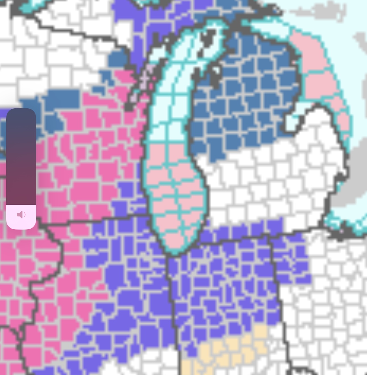
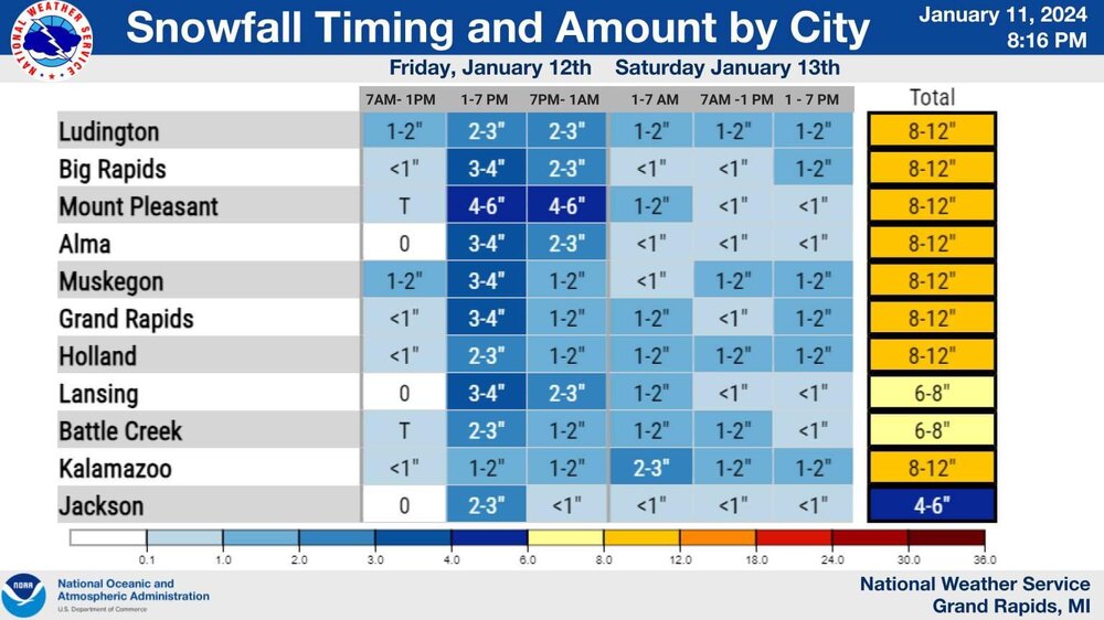
GRR just put out this graphic. Very reasonable and in-check totals it would appear. Differs entirely from the point and click forecasts and everyone on Facebook is having a meltdown over it. Love to see it.
-
The differences among the models this close to the event is downright ridiculous. Some of the short range guidance is still over-doing the warm tongue aloft, while others don’t have it at all creating massive differences in snowfall. It would make the most sense considering the strength of the slp to draw in warmer air at the surface (33-35°) while the low passes nearly overhead here and to the east, with that, there will be rapidly dropping temps on the backside of the low drawing in much colder air at the mid levels and the surface as it moves northeast. If this thing suppresses a little quicker, colder air will be realized sooner thus more snow. At the end of the day it’s really a crapshoot but around here I’d expect the snow to mix with rain for at least a few hours tomorrow late afternoon and to pinpoint any accumulation depends on how much rain actually does occur.
-
Gotta love it. Nice having you in here!
-
You and I both. There’s such a wide range of possibilities with this it’s ridiculous. GFS has been very consistent with this system, but wouldn’t mind a bump southeast. HRRR and other short range guidance giving us another cold Eurythmics special.
-
In house model? Or is it the GRAF model?
-
Winter '23-'24 Piss and Moan/Banter Thread
Harry Perry replied to IWXwx's topic in Lakes/Ohio Valley
Crazy how there’s over a week of consistency followed by a 200+ mile NW trend inside of 48 hours. Twice. -

-
That map gives me flashbacks of a few days ago for today.
-
Excellent consistency. This solution screams mixing/dry-slotting issues for pretty much all the areas that got shafted today as well. Will be sampled tomorrow, should give us a better picture on what’s going to transpire, LOTS of moving pieces with this. One thing for certain, GRR will issue an advisory regardless of the outcome.
-
Kinda has that look to it honestly.
-
Similar to today, but a little closer/better than 10:1
-
Winter '23-'24 Piss and Moan/Banter Thread
Harry Perry replied to IWXwx's topic in Lakes/Ohio Valley
Ironically enough mine just set off the “low sensor battery” about an hour ago as well. -
I agree, end of the week looks impressive for us. My point was - in typical GRR fashion, we will be last to jump on the bandwagon for headlines until the event is damn near underway or nearly over - for the first appreciable snowfall of the season.
-
Already am. Old trends die hard.

-
Makes sense considering the spread. Chances of an outlier verifying are relatively low.