Kevin Reilly
-
Posts
3,401 -
Joined
-
Last visited
Content Type
Profiles
Blogs
Forums
American Weather
Media Demo
Store
Gallery
Everything posted by Kevin Reilly
-

1/6 snowstorm - nuisance event or something bigger?
Kevin Reilly replied to LVblizzard's topic in Philadelphia Region
Only problem it's on an island by itself for now. -
E PA/NJ/DE Winter 2024/25 Obs/Discussion
Kevin Reilly replied to JTA66's topic in Philadelphia Region
Currently 31f Cloudy with snow flurries flying: Looks like a pretty good snow shower moving rapidly southeast on the back side of our blocking low pressure that needs to leave like now in order to get out of the way for Monday if we want appreciable snow. Total Snowfall in Media This snow season: 1.88" -
1/6 snowstorm - nuisance event or something bigger?
Kevin Reilly replied to LVblizzard's topic in Philadelphia Region
I mean this thing is just getting crushed south. Hope this confluence helps us with the big one later!! -
1/6 snowstorm - nuisance event or something bigger?
Kevin Reilly replied to LVblizzard's topic in Philadelphia Region

-
January 3, 2025 Light Snow Event Observations
Kevin Reilly replied to ChescoWx's topic in Philadelphia Region
That's what happens when you train a great network of trained NWS spotters. -
To me isn’t this what the gfs and other models showing lobe up north moving further away. I really have a tough time trusting 18z runs there not called off runs for nothing. I’ll be patient until 0z to see real lasting changes or trends as I wave good bye to this little pesky storm stage right and get outta the way of the more important storm on Monday.
-
January 3, 2025 Light Snow Event Observations
Kevin Reilly replied to ChescoWx's topic in Philadelphia Region
30f currently dew point 21f wind NNE 7 mph Total Snow: Coating 0.35" or so underwhelming You can see the low developing to our SE rapidly moving ENE and away....>>>>> That's it leave get out of the way get outta here for and out of the way for our Monday storm. -
You forgot one where the best snow ratios set up in the coldest air on the northern side of the precipitation field.
-
1/6 snowstorm - nuisance event or something bigger?
Kevin Reilly replied to LVblizzard's topic in Philadelphia Region
Actually, those higher amounts in DCA Baltimore and across Delaware into South Jersey very well could be that warm nose aloft causing sleet. -
1/6 snowstorm - nuisance event or something bigger?
Kevin Reilly replied to LVblizzard's topic in Philadelphia Region
https://x.com/chris_fukudawx/status/1875285611466363212?s=46 Ok fun -
January 3, 2025 Light Snow Event Observations
Kevin Reilly replied to ChescoWx's topic in Philadelphia Region
We are the real weenies!!! Holding out hope to the final round, but it feels right to do. pixe dust flurries here 36f so victory! -
January 3, 2025 Light Snow Event Observations
Kevin Reilly replied to ChescoWx's topic in Philadelphia Region
Ralph further north maybe! Not one flake here in Media skies brightening from the southwest. 36f -
January 3, 2025 Light Snow Event Observations
Kevin Reilly replied to ChescoWx's topic in Philadelphia Region
100% Ralph exactly my thoughts. Note the movement straight east it would not take much to bend the overall flow behind this system a bit more southwesterly aloft. Also as modeled 24 hours ago this little system doesn’t appear nearly as dynamic or strong from my eyes. -
1/6 snowstorm - nuisance event or something bigger?
Kevin Reilly replied to LVblizzard's topic in Philadelphia Region
See if the gfs moving lobe over Maine out makes a difference starting at 18z look closely there’s a nudge northeast.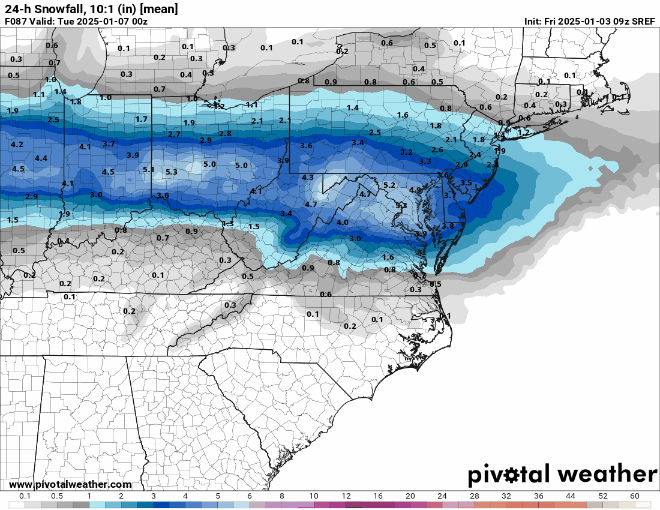
-
1/6 snowstorm - nuisance event or something bigger?
Kevin Reilly replied to LVblizzard's topic in Philadelphia Region
Looks like a band setting up just south of the Turnpike in Chester County so there is that heading due east. Also, I am still willing to bet( not too much money though) that models tick northbound tonight when our system today leaves stage right. -
We know the drill they will either come back together again or they will cave to each other one of the two.
-
All 0z runs tonight is your best bet to start trying to understand the final outcome. We are not quite there yet in my opinion and past experience following models and past set ups including this potential set up.
-
That piece is key for northern parts of precipitation field because less qpf and higher ratios obviously means more accumulations.
-
Looks like it opens the door at the last minute for a climb northeast classic look
-
1/6 snowstorm - nuisance event or something bigger?
Kevin Reilly replied to LVblizzard's topic in Philadelphia Region
The orientation is completely changed on this model from 3 pm yesterday a NW to SE flow is very apparent on this map now can this NW flow move out quick enough for Monday think this set up holds the keys and what’s going on up north -
1/6 snowstorm - nuisance event or something bigger?
Kevin Reilly replied to LVblizzard's topic in Philadelphia Region
My thinking this is where south trend halts and Euro perhaps the gfs begins the bounce back towards final northern solution bringing warning level snow to Southern Pa and SE Pa Jersey south of Trenton -
1/6 snowstorm - nuisance event or something bigger?
Kevin Reilly replied to LVblizzard's topic in Philadelphia Region
Totally based off 0z and lesser extent 6z runs call it forecasting model run to model run but it’s a first call I’m assuming I don’t have a problem with it but it’s perhaps becoming clear adjustments are incoming? -
1/6 snowstorm - nuisance event or something bigger?
Kevin Reilly replied to LVblizzard's topic in Philadelphia Region
lol the band keeps shrinking clearly the NAM is only worried about frontogenetic forcing -
1/6 snowstorm - nuisance event or something bigger?
Kevin Reilly replied to LVblizzard's topic in Philadelphia Region
lol Nam band looks much tighter smaller if you would -
1/6 snowstorm - nuisance event or something bigger?
Kevin Reilly replied to LVblizzard's topic in Philadelphia Region
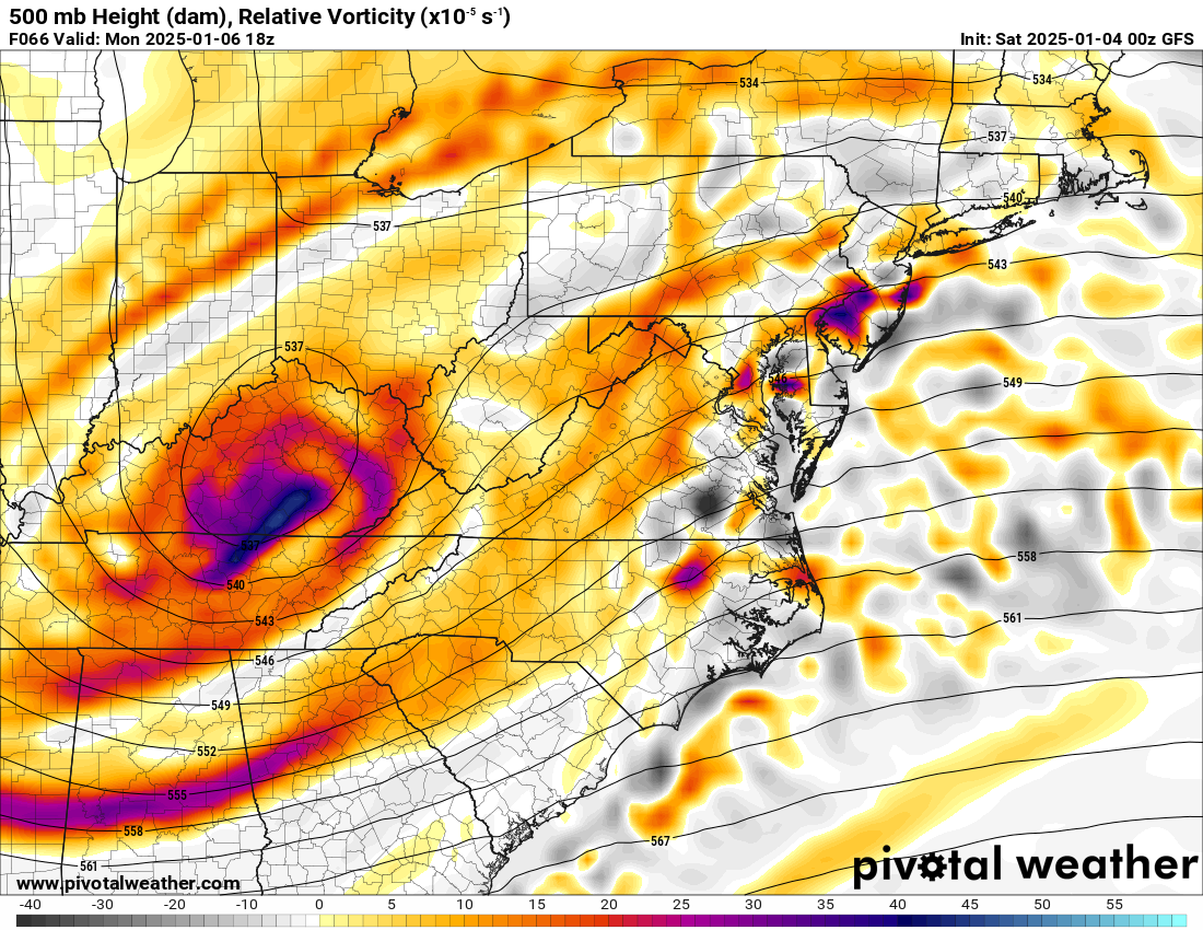
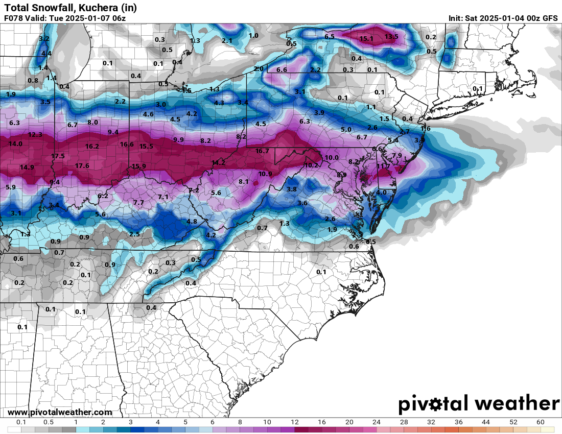
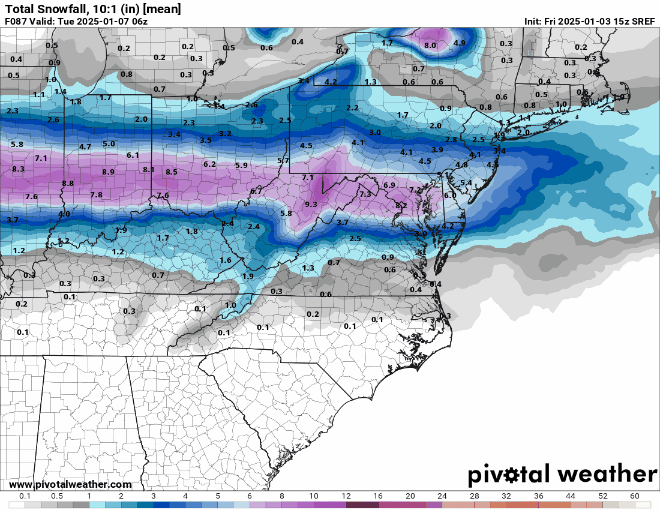
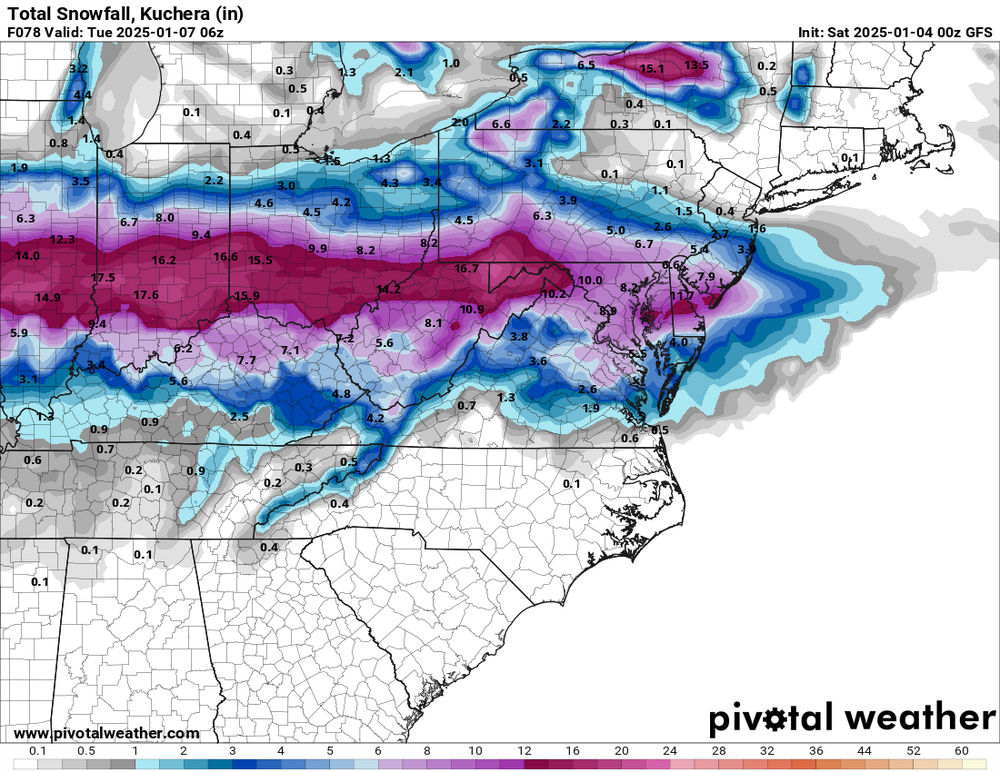
Monday, January 6th First Call and Thoughts: The south trend on the models is undeniable but I am willing to wait and see how this works out over the next 24 hours. While the models have taken the storm center further south a bit. It looks like the models are trying to figure out how much liquid is involved for the storm. South through DCA and Baltimore across Delaware to South Jersey for instance looks like more liquid is available but temps are a bit higher in the 30-32f range. Once you get to other side of the PA / MD border to about the PA Turnpike it looks to be much colder with 0.40-.60" liquid with temps 23-26f so the results are the same on the other side of the PA / MD border relatively with less liquid so snow ratio as we move forward will be the talk for sure. I don't think even right now that the storm track is set in stone even now and we will not know for sure until at the earliest 0z runs tonight. Today's storm as someone said yesterday will leave the crumbs behind the railroad tracks if you will for the Monday storm to travel east northeast where that baroclinic zone / tracks sets up will determine the final outcome. Also does the storm hand off energy to develop a coastal quick enough and close enough to give bonus snow as the coastal takes over. At this point I think we still have more questions than answers from the model runs over night and first thing this morning. I think we iron all this out one way or another in the next 24 hours for more model consistency. In Question: 1. Storm Track (I am not sure the storm is done shifting north or south at this time this is significant part of what will happen with the storm) 2. Does the coastal storm develop close enough and strong enough to give bonus snow (this is the one I am very less confident about) 3. How expansive is the precipitation field 4. snow ratio vs liquid available to create more snow accumulations with less liquid due to colder temperatures (this may by the biggest ingredient in PA and Central NJ points northbound. My first Call: (Subject to Change but as I see it now) Through Central and Southern Lancaster County, Through Central and Southern Chester County straight east through much of Delaware County, over to just north of Atlantic City 6-8" of snow. north of the turnpike 76 / 276 4-6" Allentown, Leigh Valley over to Trenton 3-5" Poconos Tunnel north 1-3" NYC coating to 1"