

wasnow215
-
Posts
2,078 -
Joined
-
Last visited
Content Type
Profiles
Blogs
Forums
American Weather
Media Demo
Store
Gallery
Posts posted by wasnow215
-
-
18 minutes ago, Maestrobjwa said:
Bruh that thing can't even get 48 seconds right!
Exactly-as dependable as CJ Stroud
-
 2
2
-
-
31 minutes ago, RVASnowLover said:
GFS continues to be all over the place
I really think the European model had to have a little discussion with the GFS if you know what I mean. So now it came into line this time it needs to continue to come into line with King euro lol
-
 2
2
-
-
Just now, stormtracker said:
I'm good my 6 to 10 goal is still in range. What's next?
Euro snow maps? Haha
-
They gotta be panicking on the main thread lol. I don't trust the GFS at all at this far out and it's not just that I'm just making this up. If you go back and look at the last couple weeks I've been saying it. This winter season and last season, the European model has just absolutely crushed every other model and until that changes I will absolutely ride Euro-no matter what it does as we get towards the weekend.
-
17 minutes ago, RVASnowLover said:
It is the ICON so there is that. However, we do not want to see it phase more and try to become a coastal. Will be a snow to sleet event for sure if that happens.
GFS 12z definitely coming in south...it looks like a couple runs ago
-
I remember the 2016 storm-I was working that evening the day it started in Hopewell. Started as all snow, then it went to sleet for several hours and then back to all snow and like another 8" where I lived in Glen Allen.
Could happen this way again
-
4 minutes ago, SoCoWx said:
Figures the folks to our north are talking about the Canadian a lot, given it seems to pull the storm so far north that the heaviest snows are around DC, with Richmond getting several inches of sleet.
I guess we’ll see, huh?
.0z Euro is over a foot everywhere haha!! Let's do this!
-
1
-
-
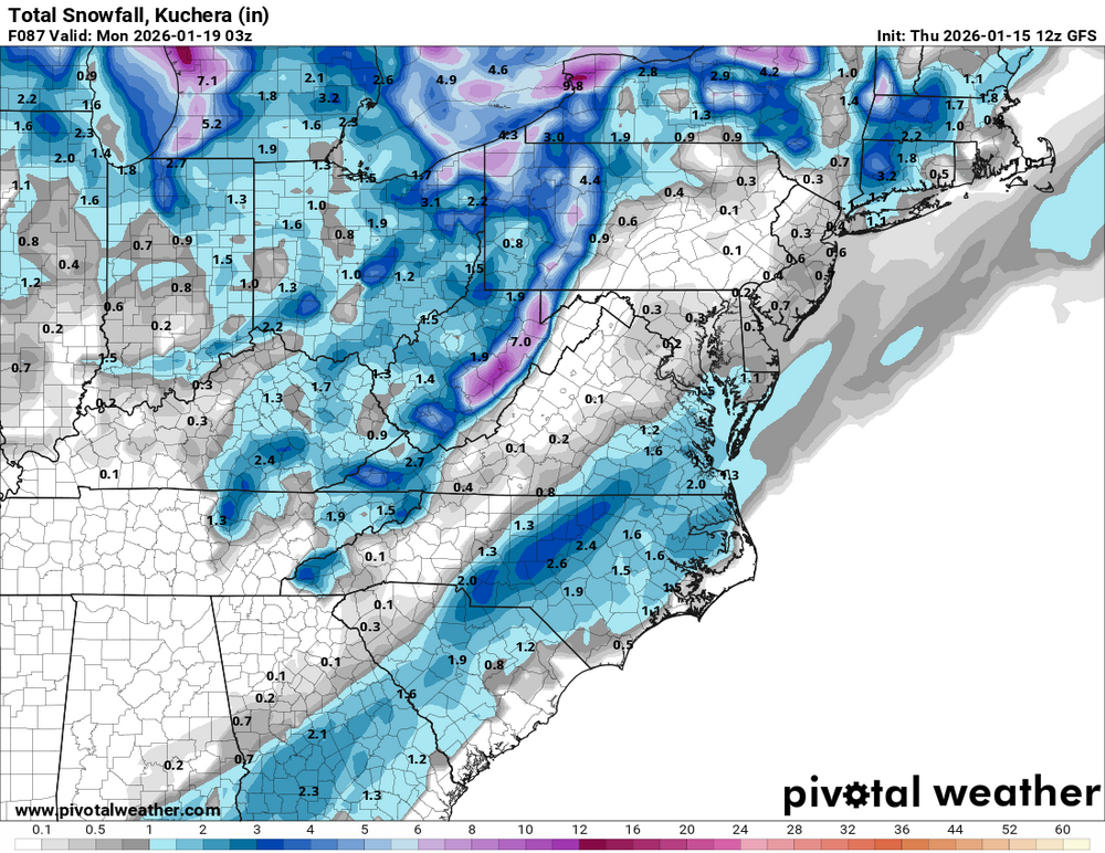
0z GFS bows down to Daddy Euro!
-
33 minutes ago, NorthArlington101 said:
If you like weenie ratios we’ve hit it already.
Would be a nice storm.
Maybe I missed someone posting this but since it's 18z run tonight, still a few hours of snow to go past 18z Sunday.
-
1
-
-
14 minutes ago, DDweatherman said:
Charlottesville has 26-32” on the app between SAT & SUN. Let the hysteria begin.
I never even realized it did it until last year. My teenage son has it and he would show me that it would go from 3 to 6 inches of snow something like that if that's what the European model was showing for where we live. And then the next day if it went up to 8 to 12 it would show that on the next model. And then if even the next model it went to one to 2 inches it would show that it's completely ridiculous
-
5 minutes ago, WxUSAF said:
If/when the GFS shows a MECS, that's when it will really break out because I think that's what the Apple weather app uses predominately?
It uses the Euro
-
11 minutes ago, TowsonWeather said:
Yes, we are all very jealous of Richmond. That's why it rarely gets mentioned, because of how much people are thinking about it and wishing they lived there. Keen analysis.
I said it was tongue in cheek. Lol-I don't know you so I didn't know you were this easily offended. Have a good day -I will be more careful with your feelings from now on.
-
13 minutes ago, TowsonWeather said:
He probably counted on your ability to extrapolate between 10-14 and 15-20.
You're right-Or there's jealousy (and this is totally tongue and cheek because I don't have your kind of sarcasm built-in ha ha), over the fact that where I live had as much or maybe more snow than you guys did last year hahahaha. And had significant snow 10 days after Thanksgiving this year.
-
Just now, LeesburgWx said:
It snows there?
Lol-I live southwest a little bit of Richmond, in Moseley, Virginia. We had a few good hits last year and the Monday, 10 days after Thanksgiving or whatever had about 5 or 6 inches. It's been a good run down here.
-
5
-
-
11 minutes ago, bncho said:
VA/NC border probably 15-20"
DC probably around 10-14"
Baltimore probably around 8-10"
Lol -you skip RVA on purpose???
-
2
-
-
There is a lot of noise on the other main thread because the Canadian that just came out is showing mainly sleet in our area. I will continue to lean at least 70% towards the European model throughout this week. It just keeps winning. And if it goes the way of the warm nose and getting sleet then that's probably what's going to happen. But I'm certainly not putting any eggs in any basket because of the Canadian model lol.
-
1
-
-
18 minutes ago, Terpeast said:
Still thinking gfs/gefs may be overdoing the cold dome, its a known bias a week out. Not every day we get 1050 highs rolling in south from canada
Yes-and also the European model has had this GFS model for lunch for going on to winter seasons now it hasn't even been close. GFS has been woefully bad, especially outside of 72 hours.
-
1
-
-
Snow covering grass and car tops here in Moseley/Magnolia Green. According to radar should end fairly soon.
-
Euro about to win again-big time. Even with the changeover happening now, the precip will be out of the region very soon. And man oh man it sure has a pretty snow storm on 12z for our region for next weekend!
-
5 hours ago, high risk said:
One thing to watch for later today: The NAM and RGEM end the event by mid or late morning for everyone west of the Bay, while the GFS and some HRRR cycles have precip ending by late morning but then bring another round of snow for DC and points east later in the afternoon.
If it's been talked about I'm sorry. But it seems we are back to Euro clearly being GFS's "daddy" again, for more than a year now. Here we are at 6z runs and Euro continues to show very little snow for Central Va and mostly rain, while GFS brings 1-2" of snow later this afternoon/evening.. I'm thinking Euro will hold again but we shall see.
-
1
-
-
Late next weekend into the beginning of the week, which starts January 26, looks like a terrific pattern for at least an MECS, which could give us at least several inches of snow.
-
1
-
-
6 hours ago, ldub23 said:
0Z GFS says dont punt, go for it on 4th down
0z Euro says "TFL on 4th down....downs".
-
41 minutes ago, chris624wx said:
Definitely backed off from 00z last night, though still a small event down this way and NE NC.
I think 6z was next to nothing sorry. I have a feeling that by the time we get to 48 hours from now the GFS will be aligned with the European model no matter what that is
-
From a fellow weather buddy of mine ...
"Gfs's pattern of inventing massive snow storms and then backing off as we approach is impressively consistent. It's like the Cleveland Browns of weather models."
Hahahahahaha!!
-
1
-

Richmond Metro/Hampton Roads Area Discussion
in Mid Atlantic
Posted
Someone sent me a text that GFS AI was huge for RVA-20"