

wasnow215
-
Posts
875 -
Joined
-
Last visited
Content Type
Profiles
Blogs
Forums
American Weather
Media Demo
Store
Gallery
Posts posted by wasnow215
-
-
7 hours ago, RVASnowLover said:
Considering how awful this winter has been, I will take 1-3" and run with it.
He’s a troll man.
-
Gfs is dry. 0z Euro has a bit more now. But less than an inch total.
-
4 minutes ago, Siberian-Snowcover-Myth said:
Not sure if this has been mentioned, but the NAM is the model that sniffed out the snowstorm we had in Richmond on Dec10 2018. It was head and shoulders above the others. Even I was weary at the time, but the NAM nailed it. We received 13” just east of RIC. Not saying it’s correct, but worth noting.
100%. Cept it was Dec 9th
-
 1
1
-
-
3 minutes ago, eaglesin2011 said:
A few nice north trends tonight on the models even the Ukie.. Richmond even now right on the cusp of a decent snowfall
For this winter it’s more than the cusp lol. The 0z NAM is like 12/9/18. Just that model tho.
-
Just now, wawarriors4 said:
I was casually interested, now I’m a bit more than casually interested, but with the way this winter has gone, I won’t feel great about it til it melts Saturday, lol. Been some good North bumps so far, Here’s hoping they continue.
Yes it’s been awful, but not a “now you see a storm, now you don’t” awful. It’s just been nothingness. Here is something at least.
-
 1
1
-
-
32 minutes ago, psuhoffman said:
Yea...I assumed it was meant to be a parody
Haha. Unfortunately it’s not. Jaded emotionalism lol. But not parody. FWIW 0z NAM is north btw.
-
18 minutes ago, psuhoffman said:
Wait that post was supposed to make sense?
You mean his?
-
5 minutes ago, CentralVaNATS said:
Yep it is a big if pattern for any trackable threats just like January and February have been but at this point we should let it go. Sun angle at work
But hope something materializes for even a 6 hr event come March
Sent from my SM-N960U using Tapatalk
Meh. When tracking it doesn’t matter what has happened earlier in the season. And as far as sun angle? It’s generally an overused cliche and definitely doesn’t matter when it’s dark. Plenty of late winter/early spring events the past several years.
-
Actually 18z has something. Which is better than the nothing we’ve had all winter so far lol.

-
-
3 minutes ago, NovaTarHeel said:
Holy crap, quite the storm just rolled through Midlothian, VA. Incredible wind gusts and hail.
I’ve been trying to tell everyone on the RVA thread all day Nova lol
-
1
-
-
39 minutes ago, yoda said:
3km NAM had more of a line sweeping in from the west... HRRR had more of a "discrete storm" picture IMO
04z HRRR lookin like 3k Nam. Not good.
-
Tornado watch issued just now! Wake up RVA!
-
7 minutes ago, yoda said:
3km NAM had more of a line sweeping in from the west... HRRR had more of a "discrete storm" picture IMO
I’m no expert but to me current radar looks a lot more like 3k Nam at 0z than the latest HRRR.
-
1 minute ago, southmdwatcher said:
Ugh, the bands coming out of NC are looking to set up a train. Along with the significant parameters for severe. We get a taste of Dixie Alley tonight, hopefully without any pain.
So Md may have a rough go
-
1 minute ago, yoda said:
So looks like HRRR wins over 3km NAM
How so? You think more spotty and mainly east of 95?
-
1 minute ago, southmdwatcher said:
Well, it is certainly a good thing that we did not have any further elevated levels of instability earlier to aid these storms. The line across the Appalachians is breaking up somewhat into segments and discrete storms and segments are dominant east of the Blue Ridge from here south to the Carolina's.
So you think short term weather models are wrong showing redevelopment?
-
Am I the only one paying attention to this severe wx threat late tonight?
-
-
Not enough lol
-
Any thoughts on tomorrow night’s/overnight into Monday severe threat?
-
Any thoughts on severe for tonight in RVA by anyone?
-
6 hours ago, high risk said:
I had been "way out" on this event, but the 12z NAM3 is making me reconsider, with some impressive signatures much further north than in previous runs along with greater instability and a shear profile that is lacking in low-level shear but would have decent deep-layer shear with a modest increase in sfc winds. This solution is an outlier for now, but I'll be curious to see whether the HRRR trends in its direction.
18z NAM 3k looks bullish for tonight also for RVA. Around dark looks like biggest risk time no?
-
1 hour ago, whetherphl said:
Do you guys think this is going to affect flights into PHL late Wed night? Have to get back into Philly by then at the latest and want to know if I should change my flight....
Many weather models have surface temps at or below freezing in Philly as late as 8-9pm. Yes there will be travel disruptions. Hope all goes well!
Richmond Metro/Hampton Roads Discussion
in Mid Atlantic
Posted
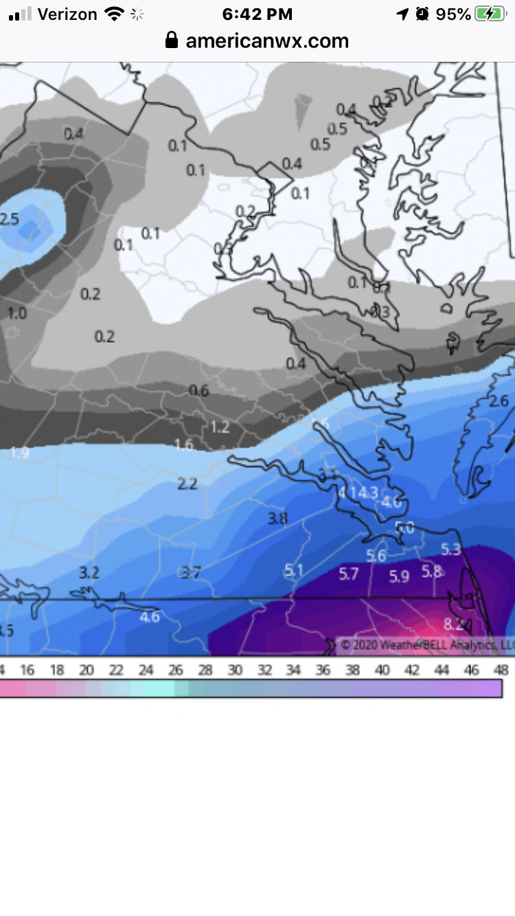
1-3” for RVA. least NW areas. Most SE areas. Possible 4” snow lolli.