

wasnow215
-
Posts
875 -
Joined
-
Last visited
Content Type
Profiles
Blogs
Forums
American Weather
Media Demo
Store
Gallery
Posts posted by wasnow215
-
-
Expect WWA’s to be posted late tomorrow in RVA, with an outside chance of a WSW (watch) because of poss freezing rain on top of a couple of inches of snow Wed morning. Today’s model runs will help NWS decide.
No matter what, Wed morning commute is going to be rough, until the CAD is eventually scoured out of the region, later that afternoon.
-
19 minutes ago, RedSky said:
The soon to be retired old GFS the only model with a clue last storm
Don’t think it does well sniffing out CAD at this range. We will know in about 60 hours or so.
-
Just now, ers-wxman1 said:
Click to animate
Really?? You got me. Totally thought the water was gonna turn to ice!! Lol!
-
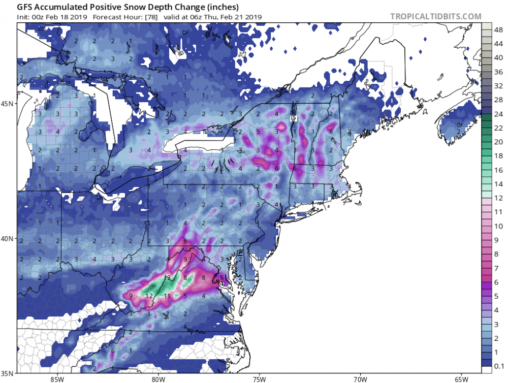
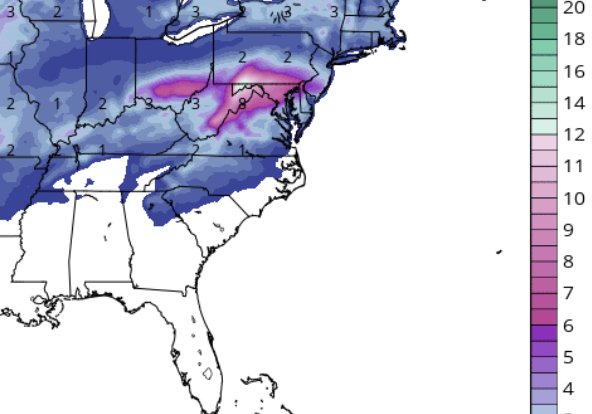
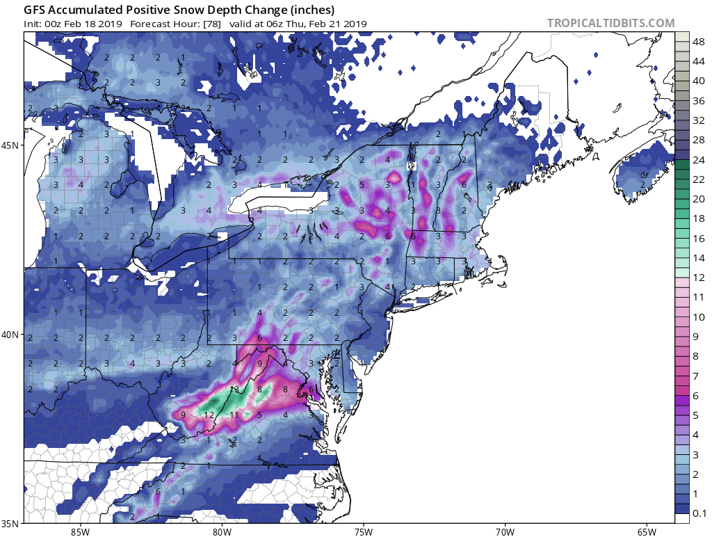
This is 0z NAM “snow depth” not 10:1. At storm’s end.
-
No idea what thread to post this looking at the sub forum but ummm did any of you look at the 0z NAM? I have family in SJ. This could be a pretty big deal. Do you have a Feb 20 thread? I didn’t see it.
-
What is going on with the Feb 19-21 storm threat thread and the Mystical Feb medium to long range threads? Lol. The Feb 19 to 21 one is talking about nino rains in Cali amongst other things, and the other one is talking about global warming.
-
 1
1
-
-
Is Chill still “holding out” (meaning like football haha) for this storm?? Are there at least ‘contract talks’ ongoing???
-
18 minutes ago, NorthArlington101 said:

Very meh
-
 1
1
-
-
1 hour ago, Snow88 said:
Check out the gfs after the 25th
Wow
Nothin special there
-
Heavy wet snow here at my job in Mechanicsville. Big giant flakes, maybe the biggest I’ve ever seen.
-
9 hours ago, C.A.P.E. said:
Has Richmond had snow since the early Dec event? He mad.
A few inches just NW of Richmond for me, along with sleet. I’m somewhere around 18-19” total for the season so far.
-
8 minutes ago, KamuSnow said:
I didn't realize we were ignoring it. Personally I like what it shows, but a blend is meaningful, especially with mesos at this point (for the next 48 hours). We're not against it, lol.
I’m only going by what I’m reading, And I am seeing more of the American models then the Euro. I have family all over SJ, and they count on me to help w forecasting lol. It’s such a close call, especially with part two. Even tho the NAM just “blinked” I still like part two potential. It’s a wait and see game now.
-
I still don’t understand why you all in Philly are ignoring the Euro.
-
1 minute ago, wasnow215 said:
Someone posted the euro? Meaning snowfall amounts? I see the Nam right above your post but not the euro.
I see it above me now (The post I made) but it was not here today before, only other snow outputs for other models.
-
4 hours ago, penndotguy said:
I believe that is Monday thru Tuesday event according to the time stamp
Someone posted the euro? Meaning snowfall amounts? I see the Nam right above your post but not the euro.
-
So are you folks discounting the Euro or are you just talking about round one?
-
56 minutes ago, ChasingFlakes said:
Are models such as the NAM and GFS-FV3 overinflating snow totals for our area due to modeling the sleet as 10:1 as opposed to something more realistic like 3:1? Is the GFS doing the same, as in my mind that is showing a much more realistic forecast in regards to snow totals.
Euro is even more bullish than those models. Shows at least 6” for Philly metro area.
-
Could be a nice tracking week leading up to next weekend. GFS and FV3 showing SECS for our region.
I’ll be hitting the links on Tue as it will be close to 70° here, and then focus in more on tracking that evening lol.
-
2 hours ago, Ralph Wiggum said:
0z NAM went North last minute with light snow tomorrow heaviest band right across the M/D line into Northern DE and across into S NJ. Some light accumulations even up here if the shift N is to be believed. Fluffy powder good ratio stuff.
I have family and friends who live in the 3 southernmost counties of NJ. I send out forecasts to a bunch of people and have for years w snow and big events. My call for Fri was 1-3” when I made it yesterday for those counties. I feel pretty good about it still.
-
1
-
-
3 minutes ago, I Like Snow said:
Umm, it’s cold outside and this winter sucks.
Riveting analysis
-
7 minutes ago, NovaTarHeel said:
I had a forecasted high of 51 today, but only reached 48. Starting to drop now that the rain has started. Here's to hoping we get to see at least a little bit of snow before it all ends.
45° here in Glen Allen. Forecasted high was 49°
-
Just now, RVASnowLover said:
Less than 1 inch on 18Z NAM and 3K
Like I said earlier, it’s GFS n FV3 against the rest lol. I will say I’ve never known the 3k NAM handle these types of scenarios well. Consistently too warm. Euro was kinda weak also tho. I’m riding the FV3!! Lol #weeniealert
-
34 minutes ago, Ji said:
where is the heat wave?/

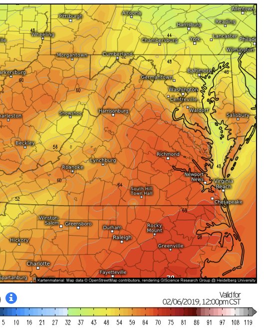
This is 12z Euro Wednesday 2/4 at noon. Pretty warm.
-
1
-
-
Just now, RVASnowLover said:
Will gladly take it. Friday might be interesting too.
Short term models are very warm so interesting to see how this plays out for tomorrow evening AND what 12z Euro looks like. CMC warm also. Haven’t looked at Fri much. Will do so later on.
E PA/NJ/DE Winter 2018-19 OBS Thread
in Philadelphia Region
Posted
Driving will be very hazardous during morning rush for you folks in the Delaware Valley and probably evening rush. At least a couple inches of snow will then change to sleet and/or freezing rain. You will not see much “regular” rain at all.
Thursday will be warmer but it will take a while.