

wasnow215
-
Posts
875 -
Joined
-
Last visited
Content Type
Profiles
Blogs
Forums
American Weather
Media Demo
Store
Gallery
Posts posted by wasnow215
-
-
18 minutes ago, RVASnowLover said:
EURO goes North. Not looking good here.
Oz Euro was north. Not the 12z that just came in
-
7 minutes ago, yoda said:
Lol GGEM... it cut back from 12z... but it probably makes more sense now
GGEM latched on to 12/9 here in RVA pretty far out. FV3 also, and the EURO followed ar 72 FWIW.
-
 1
1
-
-
What did 18z euro show for RVA? I don’t have it.
-
3 minutes ago, Hyphnx said:
From LWX: Forecast Discussion

An upper-level trough will eject out of the southwest overnight
Friday night into Saturday. An area of surface low pressure will
form over Texas in response to this upper-level feature, and
move into the southeastern U.S by Saturday night. Ahead of the
main surface low pressure system moving across the southeast,
another weak area of upper-level energy will be moving across
our area Saturday afternoon into Saturday night, which will
provide some extra lift ahead of the main system. At the same
time, a strong surface high will funnel cold air in from the
north, while southwesterly flow above the surface overruns the
wedge of cold air. This combination of moisture and enhanced
lift will result in a period of snow starting late Saturday
morning, continuing into Saturday night. Snow associated with
the main surface low looks to move in early Sunday morning and
continue throughout the day on Sunday.

On Sunday, the primary surface low pressure system will slide
by to our south through the Carolinas. The precipitation from
this system will stretch northward and affect areas as far north
Pennsylvania. Temperatures will be plenty cold enough for snow
for the entire duration of this system, so precipitation types
will not be an issue. Latest runs of the operational Euro and NAM
are in fairly good agreement that the low will move off the
coast around Cape Hatteras, while the operational GFS took a
slightly more southern track. However, GEFS and EPS ensembles
seem to be in fairly good agreement that more closely resembles
that of the operational Euro and NAM. While some uncertainty
remains in terms of the exact track, it seems as though most
guidance is in decent agreement.
Ty! Almost seems like two parts right?
-
47 minutes ago, Hyphnx said:
I'll take it, hope the temp warrants all snow and not this stupid mixing
It looks like the timing is a little later-well after dark on Saturday or even Sunday morning. Yes?
-
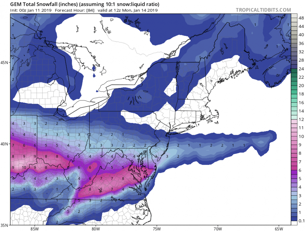
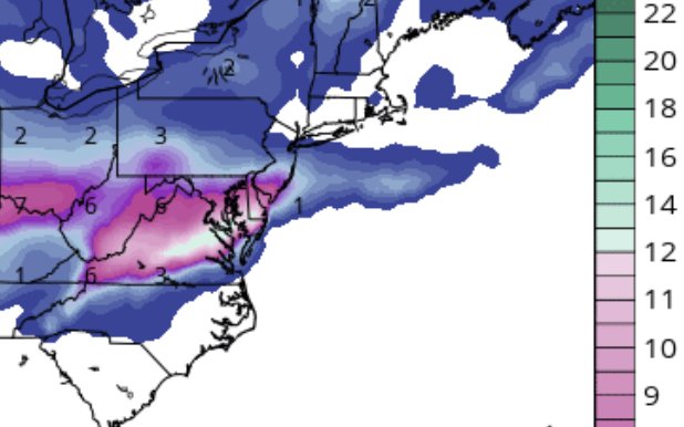
12z 1/10/19 Euro “snow depth change”.
-
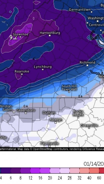
In order: Gfs, FV3, Canadian. All 10:1
-
2 minutes ago, rmcwahoo said:
I'm an amateur of course but so far midday models appear to be trending a little colder
Yes. Gfs is the weakest. Only a couple inches at 12z. FV3 4-6”, and OH Canada!! Double digits or close. At 10:1 anyway.
-
21 minutes ago, rmcwahoo said:
Can't really figure this storm out. And if you look at the local TV forecasts they can't either. I love NBC 12 right now: 4-6 inches, but maybe just an inch or hey 9-10 inches! That's called covering all your bases!
True! Better than ignoring the possibilities like they did heading into December 9. Not just NBC but many.
-
Just now, eaglesin2011 said:
It has gone dead silent in here.. Kinda surprised even if we don't receive allot of snow it still could turn into a major ice storm in parts of the area... Surprised more of you aren't chiming in... I personality believe out here in the West End we will get a 3-6 storm with maybe a little sleet/frz rain... Error margin could be high both ways of course...
I think it’s because there hasn’t been a lot of changes since we talked yesterday. The euro has been the most consistent but it seems like every run it takes off a little bit more QPF. Last time the FV3 did really well and it’s pretty weak. GFS is good but it busted 12/9. CMC also. I agree with how you see it.
-
4 minutes ago, Hyphnx said:
FV3 is running now. Barely. Might get the 18z GFS before the 12z FV3
Why has the FV3 been running so slow last few days? Govt shutdown?
-
Just now, CavalierHoo said:
Eh. Maybe I just don't want to believe it. The models will bounce around a few more times before the final result is in. Seems the models are handling the system in different ways. Who knows which one is correct.
Euro has been consistent and was also for 12/9 but not til 72 hours out for that one. FV3 and then the short range models handled 12/9 well also. Once short range came into range.
-
Just now, Hyphnx said:
Does that include sleet?
Not sure but that definitely will not be all rain now. It did shift more north and west however.
-
Just now, wasnow215 said:
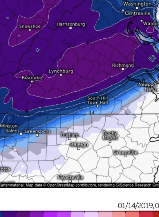
Not entirely. For those just west and north of 95 that’s still 4 to 8 inches.
-
3 minutes ago, Hyphnx said:
Euro has RIC getting rain
Not entirely. For those just west and north of 95 that’s still 4 to 8 inches.
-
12 minutes ago, Bob Chill said:
Both are pretty good analogs. Southern wave running a boundary and enough confluence to abate temp issues and also keep it from running the coast. Cold powder like both of the ones your thinking.
Some of these 30 hours of snow outputs seem unlikely. Very unlikely... pattern is still progressive and h5 doesnt close off. That eliminates long drawn out solutions in my brain but the models show it so we hug
12/9/2018 FTW
-
12/9 Redux!!
-
Where ya’ll at?? Lol. Maybe some snow/ice coming this weekend
-
2
-
-
4 minutes ago, cbmclean said:
Well, from what I have seen written:
1. Not all SSWEs propagate to the surface.
2. Not all SSWEs which propagate will impact here (instead of say Eurasia).
3. Even if it does impact us here there can be a sizable lag (2 weeks to a month).
Once we see positive impacts inside day 10, I am sure that many will be more excited.
Of course if we do see blocking, I am not sure if there is any way to know if it came from the SSWE or not
Yes good points. He said effects possibly in about two weeks but I have much respect for the “Bob’s and PSU’s etc” on here so I’m not banking at all on this. Heck coming back from 80’s and beautiful in Central Fla, so the 50’s etc in RVA is gonna feel “polar” haha.
-
Ok very good. Thank you!
-
Just checking in to see if anyone was excited about the Cohen post on Twitter earlier about the PV split. He’s pretty bullish about it. Doesn’t look like from glancing at the last few pages that anyone is buyin though lol. Thinks EC effects could poss start in two weeks or so.
-
15 hours ago, PrinceFrederickWx said:
Thanks. I added it to the tornado outbreaks option (since no one's voted for that anyway).
@wasnow215 can you move your vote to that choice now? Thanks!
Ok will do!
-
16 hours ago, PrinceFrederickWx said:
What day was that and where? I can add it.
Sorry just came back in and saw this. Large portions of RVA. Chesterfield hit hardest and one died. 9-17-2018
-
54 minutes ago, Wonderdog said:
If you look at the 500's just going back a day and a half, it's like night and day for the 22nd storm. How can their be any confidence in long range depictions from the models going out 15 or so days?
There isn’t.


Richmond Metro/Hampton Roads Discussion
in Mid Atlantic
Posted
On Euro??