

wasnow215
-
Posts
1,557 -
Joined
-
Last visited
Content Type
Profiles
Blogs
Forums
American Weather
Media Demo
Store
Gallery
Posts posted by wasnow215
-
-
3 hours ago, psuhoffman said:
I envy you this... as an Eagles fan, they've reached this spot where expectations are so high every year that there is almost no joy in the journey anymore and unless they win the SB its not a successful season. And yea I know how ridiculous that is, and I am not nearly as stupid about it as most...there are a LOT of Eagles fans that legit wanted to fire their coach when they started 2-2 this year. My father was one of them lol. I was like, ya'll full on crazy, but its just hard to get that excited by just making the playoffs when it happens almost every year. I kind of miss when I was younger and just having a winning season was seen as an accomplishment. It's less fun now.
This is so true! I took my son to the Tampa Bay game when literally they were without Brown, D Smith and Lane Johnson!
Most of the shows on WIP barely touched on those injuries the days after.
I told my son as we were walking out of the stadium, with the talent they have if those guys come back healthy and stay that way, they would be in the NFCCG.
Here we are.
-
5 minutes ago, osfan24 said:
If Ji and Jebman ever met, I think the world would explode. Most optimistic poster ever and the most pessimistic ever.
Hahahahaha like the worst of severe storms forming.
-
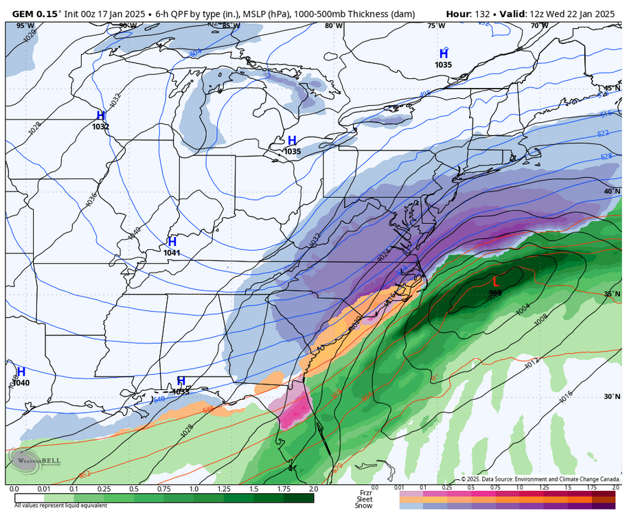
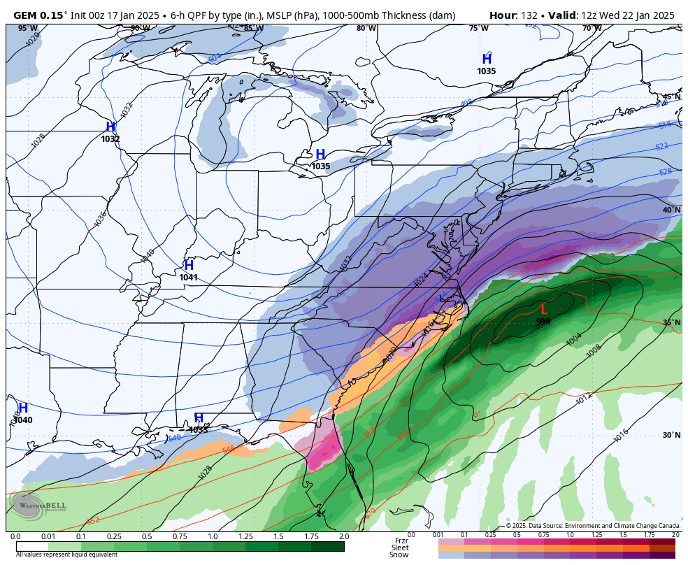
18z Euro an inch to an inch and a half snow depth area wide from south to north for Sunday evening.
-
-
I think the entire Richmond Metro area will definitely get a half inch to an inch based on the trend for Sunday evening
-
17 minutes ago, psuhoffman said:
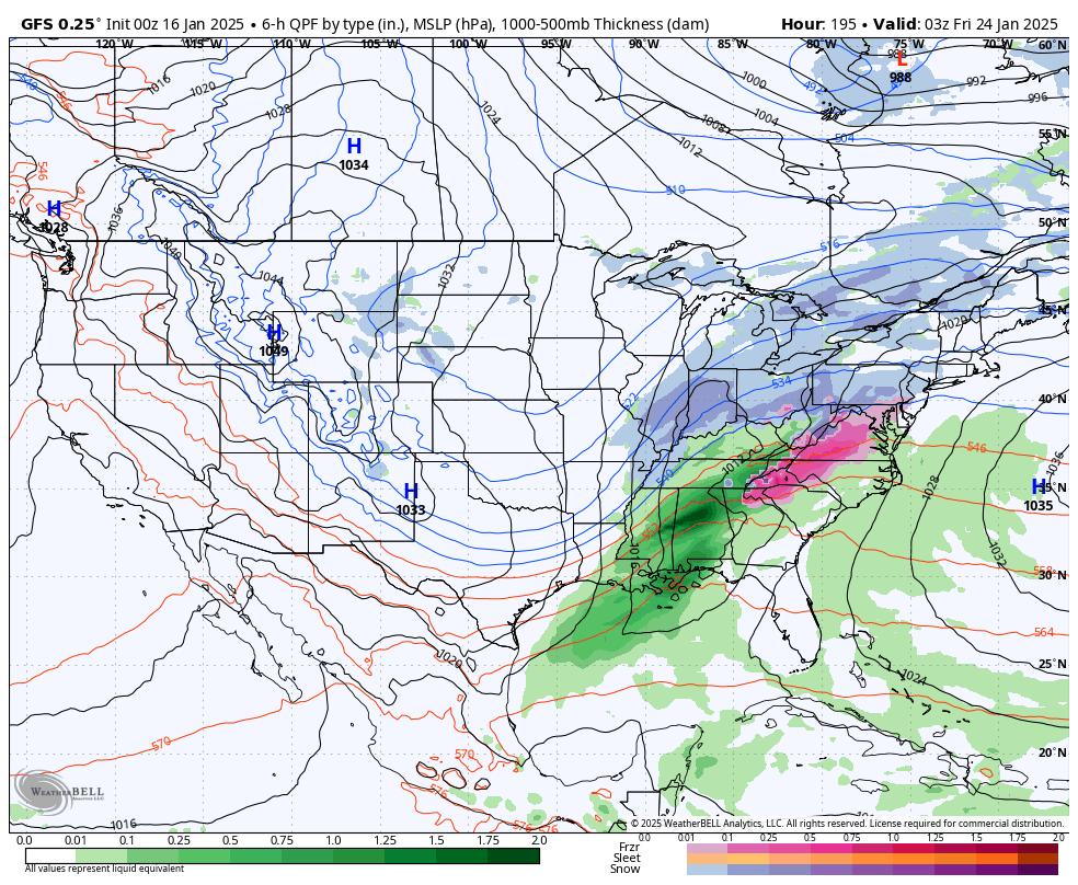
It's REALLY close with a setup around the 25th-26th but ends up splitting the energy between two closely spaced waves and both just barely miss south...but if it were to have consolidated better (not had that frontrunner) it would have been a hit. Besides the difference between a hit and a close miss at that range is noise. The potential is there in that window. I think that period is our best chance. Before that it's probably the deep south's once a decade shot at something.
Looking like it's still possible Richmond south and east could still get some snow Tuesday night into Wednesday. Interesting to see how it trends.
-
35 minutes ago, rjvanals said:
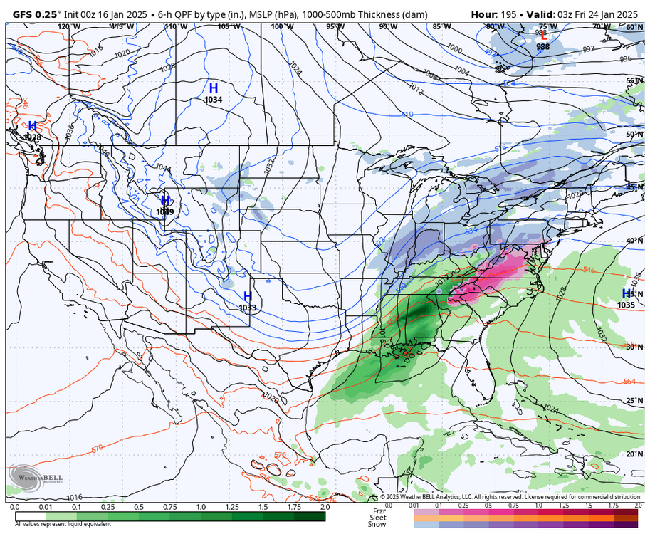
Judging by snow maps Euro doesn't have anything for us through next weekend after Sunday's storm outerbanks looks snowy though
It's actually trending more north and west every run or two. And Euro AI lookin even more NW
-
 2
2
-
-
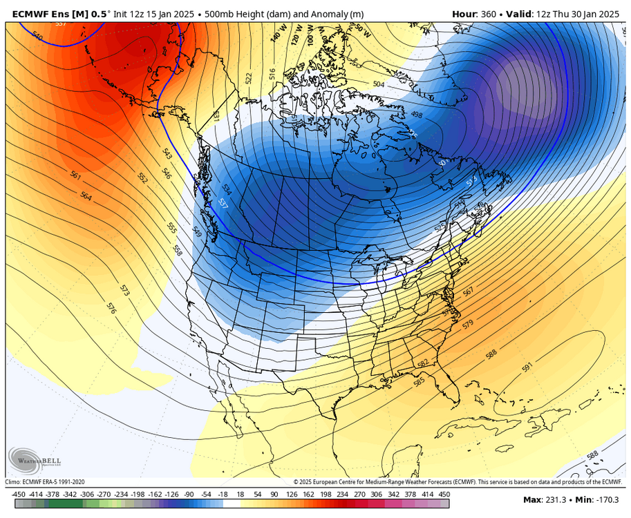
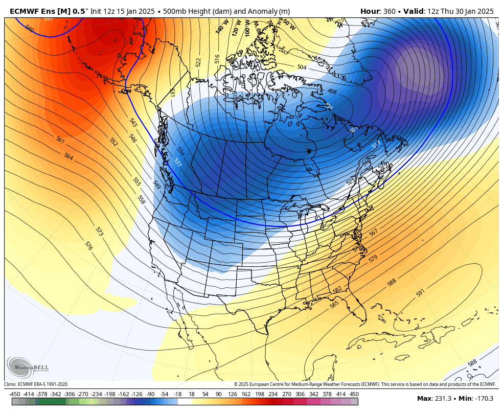
It's gonna be run to run fun until the possible pattern change as MJO goes to at least 3 after 1/30.
-
 1
1
-
-
5 minutes ago, stormtracker said:
Somebody do the euro pbp. I’m on a train heading home because apparently the water valve on my washing machine is leaking. “Badly”.

Who is "QB2"? Lol
-
 1
1
-
-
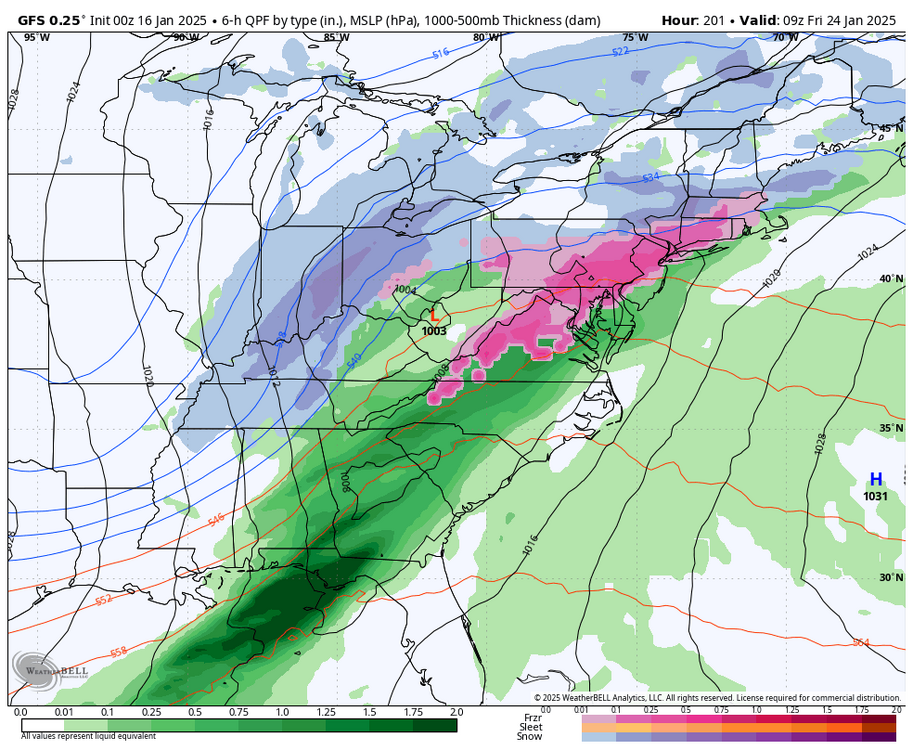
Does anyone have the ensembles for the Tuesday Wednesday Thursday possible event next week
-
1
-
1
-
-
30 minutes ago, Stormpc said:
EURO still scraping the coast and gone. It'd be nice to see some movement inland there. Otherwise I'm not buying anything. Great potential though. Like nothing I've seen in the 7 years I've been down here. There's an actual chance of a bonafide snow storm through Dixie and into the carolinas. Hopefully the EURO starts creeping back Northwest.
We do have the GFS and Canadian
-
CMC and GFS combined is a nice hit for Tue/Wed!
-
1 minute ago, RIC Airport said:
Will this model finally beat the Euro and GFS?
Oh Canada!!
-
2
-
-
4 minutes ago, RIC Airport said:
It's only slightly better than 18z, but not nearly as good as the 12z or even the 6z run from this morning. But, could be a trend back in the right direction. Looks to me for the Richmond metro area, looking at this run only, the best time for accumulating snows is between 3pm and 7pm. We will be fighting boundary layer issues and surface temps above freezing up until ~3pm. Taking this run verbatim.


Yes was comparing with 18z bc seemed like 6z was a one off. Seems qpf quite a bit higher this run vs 18z.
-
1
-
-
00Z GFS much better for Sun
-
1
-
-
2 minutes ago, NorthArlington101 said:
kuchera just for you @Ji

Eagles/Rams would be quite the snow game Sunday.
-
3
-
 1
1
-
-
NAM will handle it fine the 18z Sunday model run.
-
1
-
-
8 minutes ago, chris624wx said:
Slight NW creep on the 18z GFS for the mid-week storm. Closer than it's been in a while
Since 6z this morning when it was still a little too far west a tad haha. Not gonna really have an idea until after the Sunday thing gets out of the way.
-
Still time
-
1
-
-
Anyone have 6z Euro snow map for sun?
-
2 minutes ago, Bob Chill said:
There's been an underlying trend for nearly a month now for mid/long range models to underestimate the pushback of confluence or suppressive flow. This weekend looked more like rain than snow out in time but the speed/depth of the acrtic front trended favorably. Atmosphere seems to want to buck the trend of the much more typical "north trend" or "slow cold".
The way I look at things, the atmosphere has spoken and typical model trends that we expect aren't happening as expected. Each event is unique but until I see anything other than what has been repeating, I'll continue to hedge colder/snowier on all threats mid range or longer until I'm told to stop doing that... lolol
Dies RIC end up with more snow than DC? It might just do that. Fun winter!
This is great thank you!!
-
Better for the next one too
-
4 minutes ago, RIC Airport said:
00z GFS is either going to be a carbon copy of 18z or actually cut well west of us.
Heard it hasn't scored well this season -a week out for sure
-
1 minute ago, RIC Airport said:
I hope so as well. Favorable patterns don't last and eventually break down, so we have to score when we can. But, when they do, do the patterns return? The end of the EPS showed a SE ridge forming.
Phase 3 of MJO would be ok. Phase 4 we torch.


January Medium/Long Range: A snowy January ahead?
in Mid Atlantic
Posted
What the outlook for January when they released the previous three month period?