

wasnow215
-
Posts
875 -
Joined
-
Last visited
Content Type
Profiles
Blogs
Forums
American Weather
Media Demo
Store
Gallery
Posts posted by wasnow215
-
-
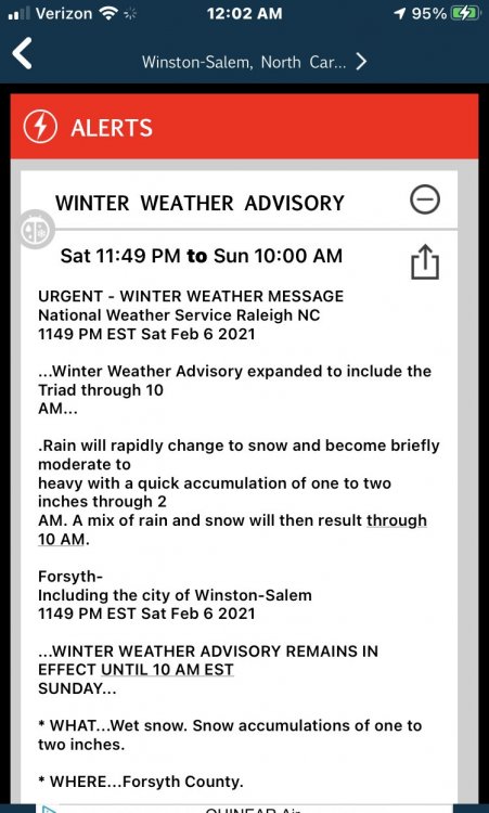
We obviously are concerned about temperatures and should be. But a few interesting notes regarding what’s happening in places that weren’t supposed to get frozen precip. Here’s one from the triad in North Carolina. Notice it says they are “expanding the winter weather advisory”.
-
 3
3
-
-
Interesting trends on the short term models. It wasn’t until recently that we were seeing the models show rain to snow to rain back to snow again. Nam is showing that and so is the HRRR. And they hang onto the snow a little longer. Could help.
-
1
-
-
30 minutes ago, RVASnowLover said:
Yeah bad time for the radar to be down
Weather bug is still working.
-
1 hour ago, T. August said:
12z GFS completely dropped the frigid temps in the MA. It does however have a big dog lurking at like 216-270.
Not completely. Still right around 0° next Monday morning 2-15 with windchills well below that.
-
1 hour ago, feb11th1983 said:
51 degrees in Powhatan right now. That doesn't mean it won't snow but it doesn't have me optimistic.
It was relatively warm last Saturday also
-
2
-
-
2 minutes ago, losetoa6 said:
Montgomery/Howard jackpot on Euro 6z . Back to normal

Anyone have 6z Euro maps?
-
Exactly-and seems like even the best of them are clinging to any random model that supports bigger snow.
-
 1
1
-
-
It’s funny to see the regional threads and everybody getting all excited when really it’s a 2 to 4 spread everywhere LOL.. maybe a little more north of DC and into interior southern New Jersey etc.
-
1
-
-
 18z Euro is solid again
-
1
-
-
Gfs warm also. Not a good 18z trend
-
1 minute ago, RVASnowLover said:
12K was a little better but not much
NAM models didn’t handle last Sunday on Friday either did they? Just wondering.
-
1 hour ago, Rhino16 said:
Don’t waste your time sending it to Henrico, they won’t care to give anyone a snow day. Everyone is still upset from last time.
@wasnow215, I like the writeup! Amounts sound realistic, and overall it’s very professional sounding to read!
Thank you Rhino!
-
1
-
-
1 minute ago, RVASnowLover said:
Good write up. 2-4 seems like a good range right now.
Thanks man! Much respect for you so I appreciate it! For last Sunday I told the region that the snow should change to a mix or rain by 11 AM and then taper off rather quickly, and I was getting nervous around 9am. But sure enough it came through haha.
-
 1
1
-
-
I’ve been sending this to my different Richmond area workplaces- we have multiple locations all over RVA. And think I know you guys well enough now to share so I would like your thoughts if you care to give them LOL. I sent this out this morning at 6 AM.
This is a special weather bulletin:
What: Snow will most likely be blanketing our region again THIS Saturday night (tomorrow night) into Sunday morning. 2-4” of snow is expected at this time.
When: Precip will begin sometime between 7 PM n 10 PM Saturday evening most likely as light rain n will transition fairly quickly to snow. Temps will be above freezing to start and really won’t fall below freezing, but could settle in right around 32° during the heaviest of the snow overnight Saturday into Sunday. For us it could be very similar to last Sunday morning-however the storm is not as large.
The relatively moderate temperatures will help with roads, but the fact that it will be dark when the heaviest snow is falling will hurt with roads.
Sorry this is so late -the snow chance pretty much disappeared as a possibility this past Monday and really didn’t start showing up again on the models until yesterday. Plus with the day job I’ve been behind watching Criminal Minds. Lol-
2
-
-
26 minutes ago, JB Fins said:
Maybe the Euro will deliver the goods. Will check back at 1:20.
12Z Canadian was nice.
Ratios are going to be tough because I think we could be looking at six or 7 to 1 ratios.
-
1
-
-
00z Euro excellent. Temps are dicey but the 850’s hold.
-
1
-
-
Solid 00z runs. For Sunday and beyond.
-
2
-
-
34 minutes ago, MillvilleWx said:
The frame work for the cold spell is there, but just has to evolve. We were several days out from any cold a week ago, but now it's inside 5 days for the polar plunge to begin taking shape. There's a lot of consistency on guidance with the result of cold but 5 days ago was not. There was a lot of scenarios for positioning of the PV and the lobes of vorticity rotating down out of Canada. Now we have less variation for the evolution within a 5 day envelope. The teleconnection pattern screams major cold as well with increasing heights over the pole to open the door for cross-polar flow into NA. Once the cold comes in, there's nothing really going to stop it from spilling. It's all about timing the flood gates at this point.
Thank you! Great explanation.
-
1
-
-
18z Euro
-
11 minutes ago, MillvilleWx said:
I know everyone here is very interested in mainly the snow chances for the extended, but I cannot understate how insane this cold signature is for the entire CONUS on guidance right now. This would rival some of the top cold outbreaks of all time. Even the ensembles are hinting at some historic level cold over the country. There will be lots of squall potential in this setup too with that Valentines Day period that @Eskimo Joe brought up above my post as the most aggressive time frame for it. Globals will not see that squall potential until it's within short range either. Bundle up
Thoughts on the fact that GFS this past Sunday showed temps around zero for Central Va on 2/8 and Euro did for 2/9 but starting Tue drastically changed that to overnight lows around freezing for those nights. Why do you feel this will be different for 10-14 day?
-
18 minutes ago, RVASnowLover said:
12z euro with the bullseye right over Richmond. We’ve seen this before so as always being cautiously optimistic
Let’s gooooo!!
-
2
-
-
25 minutes ago, RVASnowLover said:
12z gfs is interesting for Sunday. Of course temps are an issue as always but it’s trending better
Looks like almost like late Sat night start timing wise so that’s good for accumulations.
-
1
-
-
5 hours ago, RVASnowLover said:
Euro is also not as cold next week as it was yesterday
Saw that
-
I thought GFS had something day 10 tho


Richmond Metro/Hampton Roads Discussion
in Mid Atlantic
Posted
Manson, North Carolina is showing 39° on their current weather temperature as far as forecasted hour by hour. It is 32° there now currently.