

wasnow215
-
Posts
875 -
Joined
-
Last visited
Content Type
Profiles
Blogs
Forums
American Weather
Media Demo
Store
Gallery
Posts posted by wasnow215
-
-
Roads don’t seem to be an issue from reports I’m getting. Is anyone else hearing anything different. I’ve heard from people in Ashland who had to drive and Mechanicsville.
-
4 minutes ago, Inudaw said:

3k ~ .6 to .7Ty-the trends are concerning
-
10 minutes ago, Inudaw said:
6z nam and 6z rgem give metro area between 0.7 and 0.8 inches of ice.
Was just going to say 6z mesos were looking worse with more precip. 3k NAM looked like close to an inch if I’m reading correctly.
-
14 minutes ago, chris21 said:
18z euro continues to depict a nasty ice storm with no sleet and .38 inch of freezing rain in dc, essentially the same solution as 12z.
Can you post a state map or just give me RVA plz? I only have 12z.
-
17 minutes ago, cyclogenesis said:
February 12, 2021
this Friday afternoon
510 PM EST
Quite an interesting event coming up!! Here's what the latest forecast models from Friday show:
Both of the higher definition forecast models indicate this SHOULD remain mostly a FREEZING RAIN event, in their hour-by-hour indications.
This morning's NAM MOS vs. GFS MOS had a discrepancy in their Saturday afternoon temperatures, whereby Nam kept FREEZING TEMPS at 32°, and GFS MOS went ABOVE freezing to 33° at 1 PM onward in Richmond.
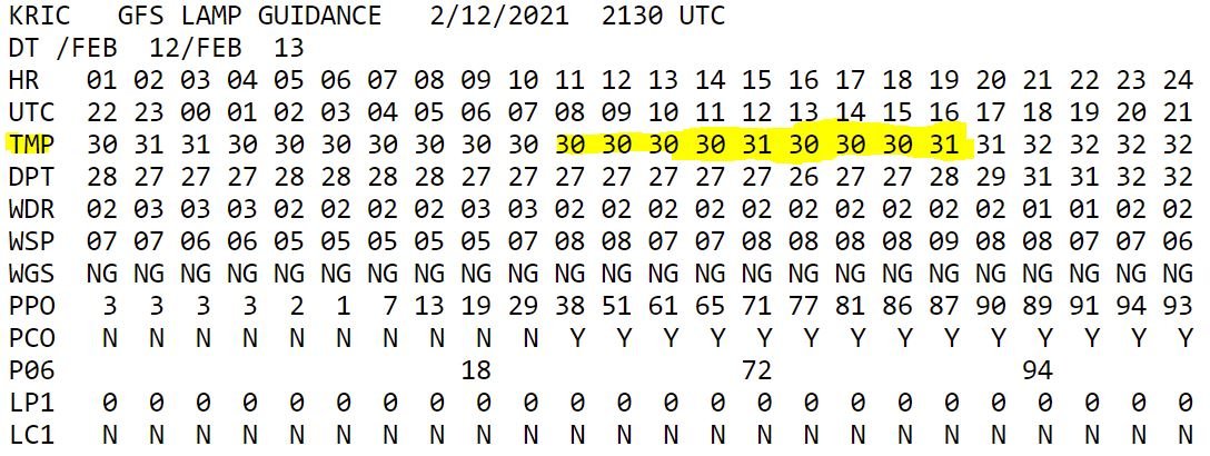
HOWEVER.... newest GFS LAMP guidance from 21Z this afternoon is REVISING these hour-by-hour Saturday AFTERNOON temperatures DOWNWARD, indicating a temperature between 30° - 32° from 7 AM to 4 PM Saturday, through the afternoon.
Looking at the forecast precipitation TYPE.... All models I reviewed are unanimous at pointing towards freezing rain, and ICING for the Richmond area. I do think there will be some periods of SLEET or ice pellets mixed in, and in any outlying areas, where temperatures hover at 33°, then that will yield a cold rain, at a surface temp of 33°, and above.
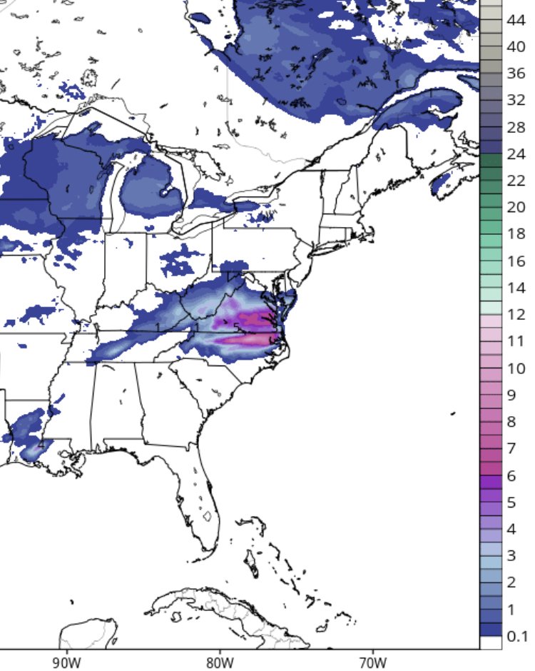
The amounts rendered are the following:
FREEZING RAIN / ICE amounts for Richmond --
HRRR -- 18Z Fri fcst iteration -->> 0.31" of ice, (freezing rain). TIMING 3 AM Saturday -- 7 PM Saturday night
GFS -- 12Z Fri. fcst -->> 0.46" of ice; freezing rain ; Timing 3 AM Saturday thru 10 PM Saturday night
GFS -- 18Z Fri. fcst -->> 0.26" of ice; freezing rain
WRF -- 12Z Fri. fcst -->> 0.56" of ice; freezing rain ; TIMING 4 AM Saturday -- 9 PM Saturday night.
NAM -- 12z Fri. fcst -->> 0.37" of ice; freezing rain; TIMING 1 AM Saturday -- 7 AM Sunday. (That's stretching it!)
NAM -- 18z Fri. fcst -->> 0.44" of ice, freezing rain
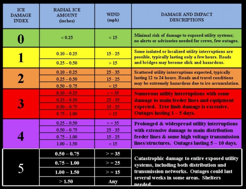
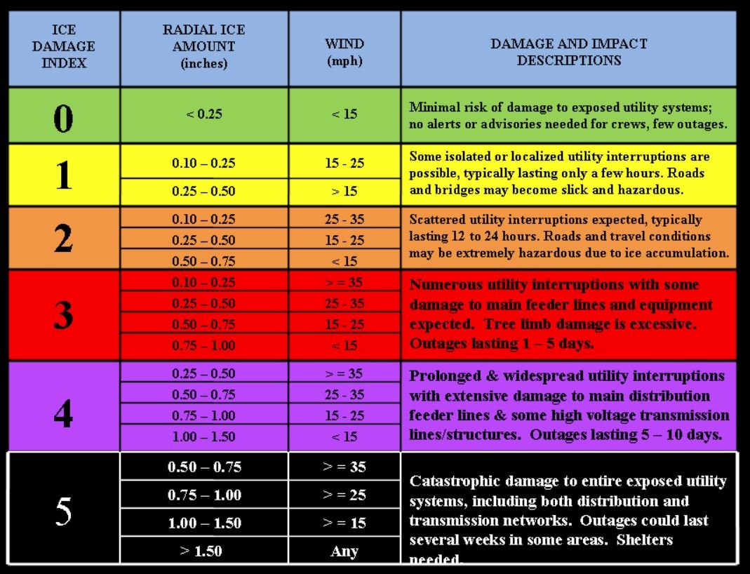
This yields an AVERAGE consensus of: 0.4" (4/10"). That is significant icing which will topple trees & tree branches, and cause power lines to sag. It is also enough significant ICING to completely CRIPPLE & DISABLE the entire road infrastructure, both secondary roads and primary roads. I can't emphasize enough to STAY OFF the MOTORWAYS, and avoid driving, starting late tonight, through all of Saturday, Saturday night & Sunday morning.
The fortunate GOOD news out of this is that WIND SPEED forecasts are expected to REMAIN BELOW 15 mph.
On the ice damage index, very damaging ice storms occur when WIND SPEEDS GET OVER 15 mph, and winds are forecast to stay below that.
Not to let your guard down, though, because lessons learned from the Dallas interstate 75 -100 car pile-up occurred in only light icing. When I checked back at all the observations at the 3 airports in Dallas - Ft. Worth, Dallas Love Field's ICE ACCRETION sensor ONLY RECORDED just 0.08" of ice accumulation ; LESS than 1/10", but still tragedy of lost control of vehicles occurred so early in the morning on a bridge pitched at a slight decline was enough to send chaos through the air. Also, yesterday, storm reports in Central Texas near Austin, during their ice storm showed surrounding communities of 40,000 left with NO POWER, when icing of 1/4" to 1/2" was encountered yesterday there.
So now, just think about the STEEP & ARCHED curvature to the infrastructure INSIDE the Richmond city limits on Interstates 64 and 95. Everyone should AVOID travelling on the roads, period. Just think of that infamous "stay-at-home" order you'd seen issued a little less than a year ago, and let this ICING event from yesterday in Dallas, be a reminder for tomorrow, in Richmond & surround areas, to STAY OFF THE ROADS altogether, from EARLY Saturday morning, all day Saturday, Saturday night & Sunday morning.
Bridges, hills & curves on the roads are especially dangerous, and Richmond's got plenty of them. Just stay at home and don't drive, from Saturday morning through Sunday morning.
How to inspect the icing?? Go look at THIN tree branches, and feel for the icing. It should be SLICK. The tree branches will SQUEAK in the wind or as you pull on them. Also, chain link fences & antennas on vehicles are other good places to inspect icing. Many vehicles on their undersides, and on SIDE MIRRORS will often show hanging icicles.
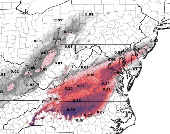
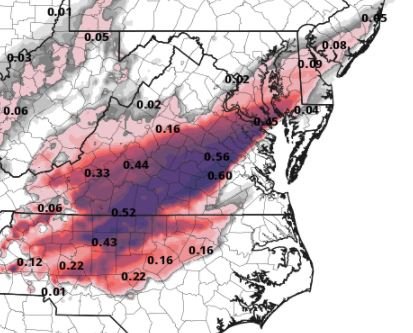
Here are the corresponding attachments that supplement this writing, supporting the ICING AMOUNT TOTALS....
-- cyclogenesis

I remember living in NYC I believe it was 1994 and even tho temps rose above 32° it took awhile for the freezing rain to become “rain” on the actual surfaces because it was landing on ice that had already accumulated. So I think it may take a little while on Sunday to get back to normal even if temps go 33° or 34°.
-
1 minute ago, mikeeng92 said:
Agreed. And Wakefield is all in.
Yes. They handled this really well IMO- I’m glad they did not wait.
-
 1
1
-
-
Looks like the winds should stay below 10 mph which is important that happens
-
Also 18z gfs colder during freezing rain than 12z. That’s the thing also. Some of the places north and west of Richmond proper could get a little less QPF but could be two or 3° colder than those south and east even though they are still freezing. This is going to be a problem
-
1 hour ago, RVASnowLover said:
I read that too and it confused me. Not sure what data he’s looking at. Almost all the short range models are showing at least .25 of ice
The guy ends up being like some weird mad scientist or something sometimes. He feels like he got burned by the European and other models in Europe the last couple weeks so now he just thinks everything is a nonevent. It’s very strange.
-
Here in Glen Allen never really stopped but lightened. Now picking up again. And if your look at latest HRRR it shows the dry slot but also shows it filling back in quickly.
-
4
-
-
Snow 32° in Glen Allen. The backfill is occurring especially the northern part of the “dry slot”.
-
2
-
-
2 minutes ago, Hyphnx said:
Hold up, what happens to all the road treatment they put down the other day? Are they going have to treat during the snow?
There will be the brine down already they use to treat this the roads for tonight and tomorrow.
-
10 minutes ago, eaglesin2011 said:
Mostly all sleet here Glen Allen/295
Same
-
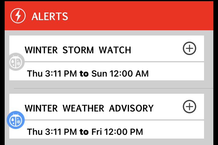
We could reach winter storm warning criteria in the Richmond area later tonight. Which means we could have a winter storm warning going on at the same time we are in a winter storm watch for Saturday lol. Haven’t seen anything like this since I lived in Northern Virginia in 2010.
-
1
-
-
9 minutes ago, RVASnowLover said:
3K nam with more snow than it had at 12z
So did 12k -18z NAM 10:1 as shown.
Now… I tend to look at "positive snow depth change" because it's more conservative and generally more accurate. It has 3" to maybe 4". However if you look at 18 Z NAM run from last night It had South Jersey at 3" on positive depth also but 4-6" on 10:1. I have family there and they were measuring 5 to 6 inches in Atlantic County and Cape May County this morning. Just an observation.

-
1
-
 1
1
-
-
3-6” final call. Obviously the lowest amounts south/SE of Richmond proper where more mixing could occur. I think 4 to 5 inches in the city north and west is very possible w lollies of 6”.
-
1
-
-
26 minutes ago, RVASnowLover said:
Be careful in that thread. They mainly talk about weather up in the DMV area. Yes the NAM has almost no ice for them. Still has ice for our area Saturday night
100% correct.
-
2 minutes ago, jayyy said:
The HRRR and what else? It looks far less impressive than it did even 2 days ago. That’s why the dropped the watches for 5+ and didn’t issue warnings for anywhere outside of the WV mountains. Advisories for Max 2” snow and a ton of slop isn’t exactly something to get giddy about, but I digress. Here’s the forecast for Richmond proper. Models outside of the HRRR don’t scream 5-10” of snow to me
This AfternoonRain. High near 39. Northeast wind around 9 mph. Chance of precipitation is 100%. New precipitation amounts between a tenth and quarter of an inch possible.TonightRain and snow, possibly mixed with freezing rain before 3am, then freezing rain, possibly mixed with snow between 3am and 4am, then freezing rain after 4am. Low around 29. Northeast wind around 8 mph. Chance of precipitation is 100%. New ice accumulation of less than a 0.1 of an inch possible. New snow accumulation of 1 to 3 inches possible.FridayFreezing rain, mainly before 10am. High near 32. North wind around 8 mph. Chance of precipitation is 80%. Little or no ice accumulation expected.Friday NightA chance of freezing rain before 3am, then a chance of freezing rain and sleet. Cloudy, with a low around 28. Northeast wind around 6 mph. Chance of precipitation is 50%. Little or no sleet accumulation expected.SaturdayFreezing rain and sleet before 8am, then freezing rain between 8am and 9am, then freezing rain and sleet after 9am. High near 31. Northeast wind around 8 mph. Chance of precipitation is 80%. New sleet accumulation of less than a half inch possible.For pretty much every midday model run snow totals have increased compared to the last few runs before 12z. Again it won’t approach 10 inches but where he had the “bull’s-eye” it will be 3 to 6 probably.
-
4
-
-
3 minutes ago, jayyy said:
“Wave 2” is dying a slow death on models. Wonder how DT is feeling looking at guidance this AM. He get rid of his 10” in Richmond idea yet

Actually wave 2 from 12Z on pretty much every model is better in the area he had 10” than it was last night and 6z today. Not 10” and it never was, but 3-5” possibly after going all the way down to 1-2” in that “bullseye”.
-
1
-
-
Just now, RVASnowLover said:
Oh haha he’s a meteorologist with CBS6 in Richmond
What was his original call?
-
30 minutes ago, RVASnowLover said:
Zach just said he’s looking to tweak his forecast for tonight based on the models. Trending better at the last minute
Lol-Who is this Zach and where is his forecast? haha
-
9 minutes ago, Wentzadelphia said:
12z icon looks much farther SE. I can’t tell if it’s doing a NAM/CMc progression though, don’t have H5 yet just slp/precip
Looks like Saturday we will have major icing according to 12z ICON in a lot of places. Looks like surface temps stay below freezing no?
-
16 minutes ago, wasnow215 said:
With mixing at times and temps an issue at the beginning I think looking at the models that have “total positive snow depth“ is smarter to look at rather than 10:1. So I think to two MAYBE 4 inches (northwest of 95) is possible.
Here is an interesting note however regarding the different models.
The NAM, the RGEM And a few other short term models handled the snow that fell in SNJ n E PA well last night into today with 10:1 ratios. Showed 3-6” and they got 3-6”. However they had pure snow and not mixing or sleet etc. So maybe 4 inches is possible here with what the short term models are showing this morning.
-
5 minutes ago, eaglesin2011 said:
Change over on the modles still showing about sunset /5pm timeframe?
Yes-Sorry I answered you without attaching LOL
Richmond Metro/Hampton Roads Discussion
in Mid Atlantic
Posted
Agreed… I’m also in Glen Allen, near Staples Mill Rd., and the 295 entrance.Agreed… I’m also in Glen Allen, near Staples Mill Rd., and the 295 entrance/exits.