

wasnow215
-
Posts
875 -
Joined
-
Last visited
Content Type
Profiles
Blogs
Forums
American Weather
Media Demo
Store
Gallery
Posts posted by wasnow215
-
-
11 minutes ago, RVASnowLover said:
Agree. I can see us squeezing out an inch or so. Temps will not be an issue.
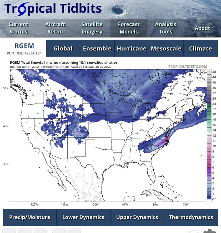
12Z RGEM is on board
-
8 minutes ago, Terrapinwx said:
For those hoping for flakes to make it north of the Potomac, keep an eye on Dewpoint trends today. Model runs that get snow into the area, such as the FV3, don’t really have a stronger or more NW low. They have less of a dry air push which allows the precip shield to expand to the north. The metros are out of the game for accumulating snow, but there could definitely be mood flakes this evening
.And here in Richmond Metro area my 1.5” I got yesterday evening could be duplicated.
-
 1
1
-
-
I’m sure there this is a wonderful banter topic now lol
-
12z NAM and 3k NAM throw a little more moisture back this way into RVA. Wouldn’t shock me to see an inch or 2 tomorrow night. It’s a tad west AND. tad stronger.
-
1 hour ago, tigersaint11 said:
First time poster, long time lurker - very appreciative of all the great posts on this thread. Lawns covered and roads starting to get a crust here in Hanover, Can't add a ton of insight but can offer tons of obs when needed!
Welcome TigerSaint!!
-
And next weekends snowicane from 12z GFS goes poof on 18z haha. Still a time period to keep an eye on though.
-
Temps dropping now-if snow doesn’t end will start accumulating soon
-
1 hour ago, psuhoffman said:
I accidentally posted this in banter but it’s relevant to our future analysis.
The Gfs love has been a bit exaggerated. It did get the Jan 3 storm right first but only by about 12 hours. The other guidance started trending north also just one cycle later. And the GFS way over compensated. 24-36 hours out it showed 6” for me and had 2-3” way up onto central PA. I didn’t see a single flake.
The Gfs was awful with the next wave. It was consistently showing .4-.6 qpf along 95. We had 15-1 ratios. That would have been 6-8” if it was right. The NAM and Euro were much much better with that storm.
It wasn’t very good with the amplified inside runner either. Actually the ggem probably did best with locking on to the extreme solution early and sticking with it. Gfs teased with a couple runs of big snow then went too far west for a couple runs then back too far east. And it looks to have been awful today. It’s been better then the joke it used to be and it’s been better than the euro but it’s not been killing it every time like some seem to think
The Euro criticism has been valid though. It’s really mishandled several NS SS interactions lately, which to be fair was a known weakness but not making excuses it’s been bad and anecdotally it seems more jumpy and prone to tangents in the medium range since the last major resolution upgrade years ago. It does do an impressive job for a global with meso scale features now but maybe it’s now got some of the high resolution CAMs issues that can become problematic with Synoptics at range. Not sure that was really a good trade. Maybe, and just speculation, having a short range euro at high resolution and a longer range lower resolution focused on Synoptics past 72 hours would be better.
So basically none of them are great. GFS is probably a “.500 ball club” this winter season so far and Euro is “10 games under .500”. (In baseball terms not football haha)
-
19 minutes ago, RVASnowLover said:
Latest HRRR has about an inch for RIC which seems more realistic unless this amps up some and we get some heavy rates
NAM seemed like moderate to heavy snow here from 3-5?
-
1 hour ago, ldub23 said:
06 gfs big improvement
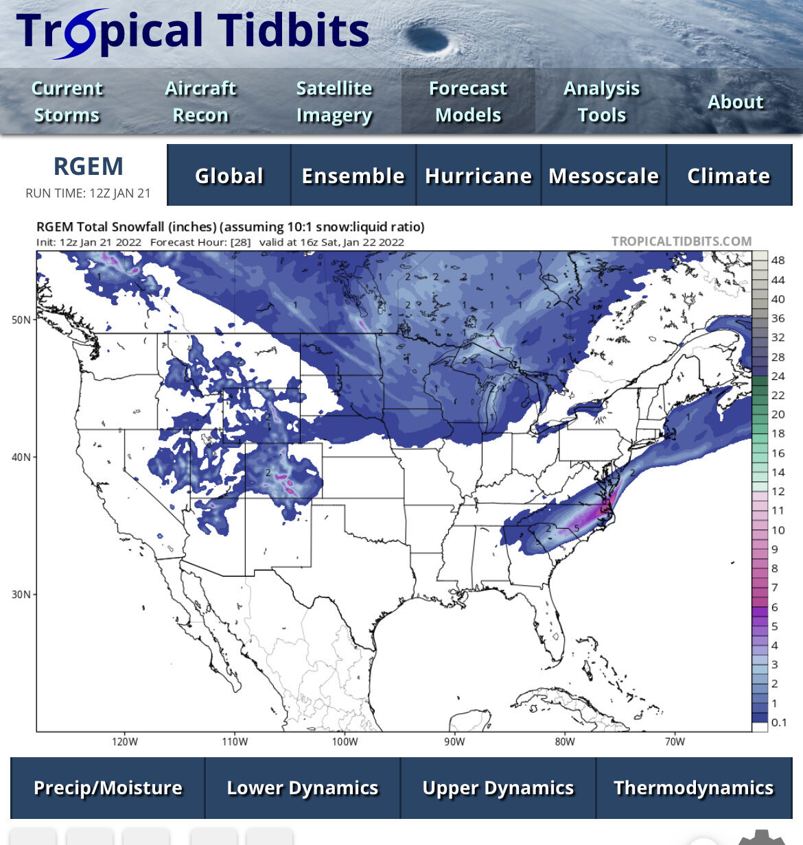
RGEM
Can’t see pictures. Unless it’s a WHITEOUT! Lol
-
1
-
 1
1
-
-
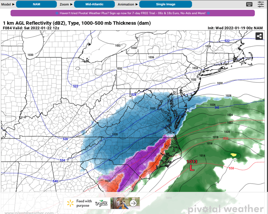
GFS better for tomorrow
-
1 minute ago, Sernest14 said:
Are these 2 storms close enough that there could be some phasing on the back end as the new low forms on the front coming through that would increase chance for prolonged snow or better opportunity Friday? Curious with the way the models are prolonging precip more new for tomorrow and if that has any bearing on the 2nd system coming in
It’s possible but no models really showing anything NW of Williamsburg now.
-
OZ NAM snow depth is maybe 1.5”.
-
1 minute ago, Sernest14 said:
Tomorrow /night
3-5??
-
Euro basically no snow. Even tomorrow just about nothing on snow depth map. Crazy
-
36 minutes ago, psuhoffman said:
Just looked…I’d be a little nervous relying all on the NS wave like that. BUT…did you see how close that was to timing up the NS and SS there. It was barely off and so it delayed the phase and was too late for us but it was super close. Even closer than the Gfs. I wouldn’t give up on the adjustment we need there at all from this range.
Around which time? 1/27 ish?
-
So much weak sauce compared to just 48 hours ago on the models.
-
6 minutes ago, RVASnowLover said:
The snow maps didn’t look like much an improvement but overhead there was an improvement on the gfs
About an inch more for RVA compared to 18z by snow depth US weather maps. Blend with models across the pond and I think good chance plowable snow. 50/50 at this point.
-
9 minutes ago, RVASnowLover said:
00z gfs is an improvement as well. Good trends so far
I think we see 2-4” min
-
Just now, RVASnowLover said:
I would absolutely take this. Looks like a crush
14:1 ratios Kuchera also
-
 1
1
-
-
Just now, WinterWxLuvr said:
We get that line to vertical .. maybe 6 hours earlier and 50-75 miles farther west … game on
I like it where it is. Here in Central Va haha
-
1
-
-
-
9 minutes ago, Inudaw said:
0z nam loves weekend....
Year it does. 6” at 84 and still snowing.
-
1
-
-
0z NAM decent for Thursday
Jan 21 - 22 Weekend SE VA and Eastern Shore Snow
in Mid Atlantic
Posted
Can we please switch the US map disco to banter? It’s ran it’s course anyway lol.