

wasnow215
-
Posts
875 -
Joined
-
Last visited
Content Type
Profiles
Blogs
Forums
American Weather
Media Demo
Store
Gallery
Posts posted by wasnow215
-
-
4 minutes ago, KAOS said:
In less than 15 minutes this is already turning into a sh*tshow.
Exactly-More than half of these comments so far hopefully get moved to banter. Garbage. And yes this one should be also but it had to be said.
-
 1
1
-
-
17 minutes ago, WxWatcher007 said:
Thread started. It’s over.
 There’s really no jinx when more than half the comments so far are people whining about frozen precip type off of one Euro run. Reading the comments instantly thought of this guy. Hopefully storm mode soon so can be they can be moved to banter haha.
-
 1
1
-
-
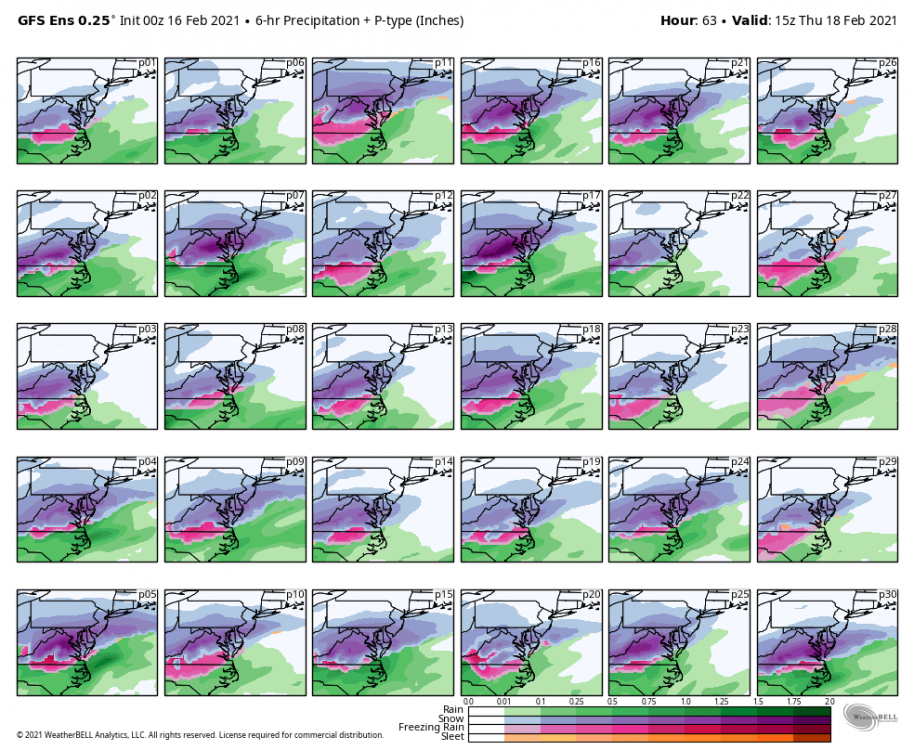
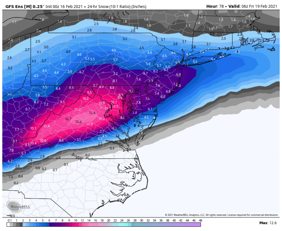
GFS ensembles are more snowy than sleety or icy. So that’s good. And not one of those is rain. From what I see anyway. Not one.
-
1
-
-
Yeah..sleet or snow. No ice. I’ll be tracking, while playing golf in Myrtle Beach lol.
-
1
-
-
4 minutes ago, Inudaw said:
Regular gfs

Para GFS
My gosh
-
Anyone have GFS ice?
-
14 minutes ago, eaglesin2011 said:
I cant stand that DT guy either.. He makes people believe that he is seeing things weeks ahead but obviously its the models.. Then blames it on them when his forecast bust...
Anyways... I think he has saying the ice wont be as bad here because he believes we will have snow and or sleet that cuts down the ice...
Well said! I think he’s more interested in being “contra-wise” more so than making the best call. So he can crap on other forecasts and forecasters.
-
2 minutes ago, Snowmadness said:
0z NAM is trending icer for RVA. Much different from 18z. Deja Vu
So now EVERY model trending colder
-
1 hour ago, Hyphnx said:
I stopped looking at his posts
Same
-
1 hour ago, Sernest14 said:
And DT back with the “no models/data show anything significant for Richmond area”- ukie, cmc, gfs all show something fairly significant along with the rdps. NAM is basically on its own island at this point
The guy has “WMPTSD” (wm is weather model lol). He got burnt in his mind so now he just quit. He sucked for the ice storm and took his ball and went home while half the region lost power and thousands of businesses closed. Big baby.
-
1
-
-
28 minutes ago, eaglesin2011 said:
Looks to me we are going to get a major ice event here or almost a carbon copy of the last storm with snow then ice to maybe rain.. definitely trending more to a ice and or snow event..
Will see how much it warms up tomorrow, still a little snow pack hanging on here
Yeah man. It’s the trends that are concerning for the ice. Hopefully this time WILL go to rain..or just be all snow! Lol
-
1
-
-
Just now, wasnow215 said:
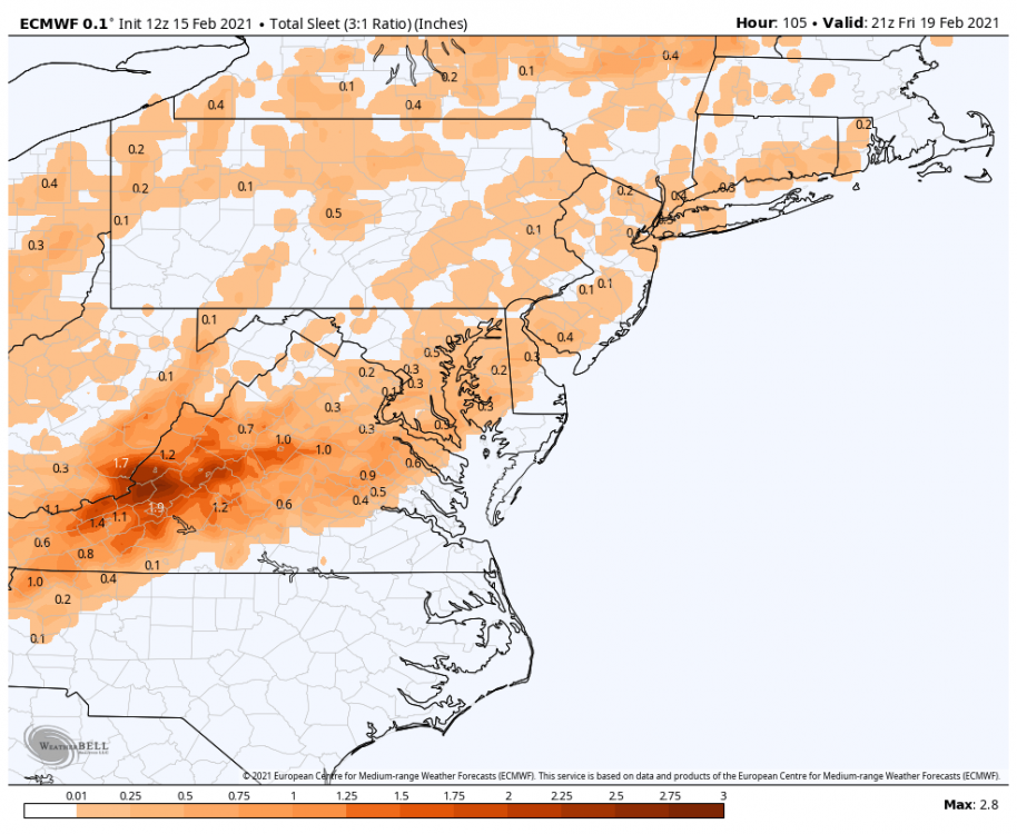
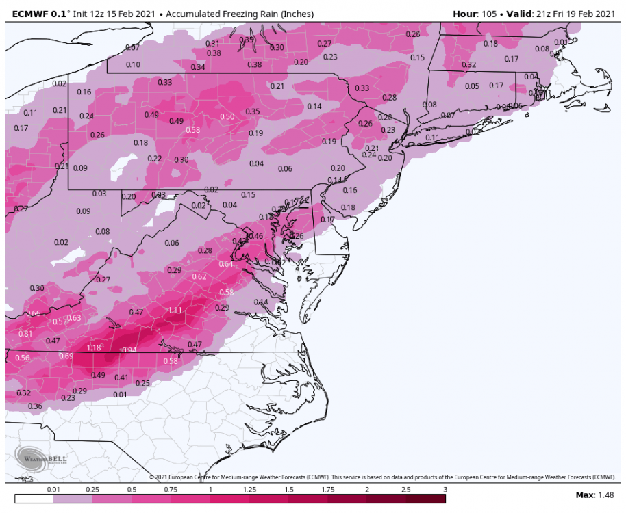
Yep. 1-2” of snow then sleet then freezing rain. 12z Euro. Wow.
-
Yep. 1-2” of snow then sleet then freezing rain. 12z Euro. Wow.
-
I don’t have exact numbers but what I can tell from US Weather is Euro is colder 12z. Snow to freezing rain. And still cold at 5pm as far as I can tell. If someone has some maps that would be great.
-
1 hour ago, Sernest14 said:
UKMET with the continued trend more south - at least in terms of expansion
RDPS (end of run so hard take with a grain of salt) shows what the GFS does - at least .5" of freezing rain
Yep that’s what’s happening. The CAD is stronger seemingly each run most of the models.
-
1 hour ago, Sernest14 said:
What model is this? Ukie?
-
Been here since 2012, live in RVA now but have so much respect for all of you. Is it safe to say the models have continued to trend colder the past 48 hours for Thursday and folks in Richmond should really start being concerned about a repeat form Sat/Sun on Thursday for an ice storm?
-
Models continue to trend colder for Thursday. Again it’s what I mentioned yesterday. 2 days ago it was mostly rain w a bit of frozen to start on models. Now? It’s a least a 50/50 split for RVA. At least
-
1
-
-
7 hours ago, ldub23 said:
If the low is more SE then you would have a long duration ice or even snow storm. But after this the low is too far west and it warms up and rains in central VA

2 problems with that and yes they are problems if it’s freezing rain:
1-Half the ensembles are major hits for Central Va
2-The pattern for the past several weeks has been one of suppressed systems as the model runs near the event.
-
1 minute ago, Steve25 said:
What? It's 3-5 days away. Literally all you can do is talk about the model outcomes right now. I understand if your bitter that model snow has not turned into real snow in multiple cases, but you're going to get annoyed with people for posting model results in a thread that is made for doing just that?
Exactly!! As I said if people aren’t here to ‘listen’ to good weather people and see what’s happening with the models then go watch ‘Netflix and chill’.
-
2
-
-
1 minute ago, ForestHillbilly said:
Yup, that's what it's about. A beat down on a model run. Who cares about the actual snow.
Lol if it doesn’t matter why even look? You could just wait and be surprised.
-
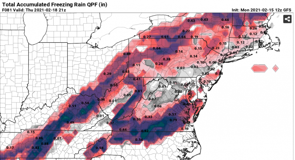
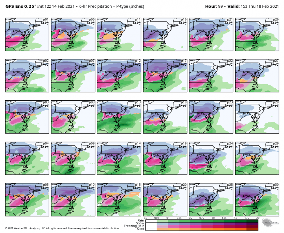
12z GFS Ensembles NOT GOOD. Half of them show another ice storm for Central Va this coming Thursday 2/18.
-
1
-
 1
1
-
-
Trees obviously an issue but just as an observation travel isn’t “nearly impossible” as a foot of snow is. Needed it to be 3-4° colder to be an extreme issue especially w roads. Again certainly not complaining, just observing.
-
1
-
-
29° in Glen Allen


February 18/19th Storm Potential
in Mid Atlantic
Posted
I GUARANTEE you it won’t be 50° in NY State. The TRENDS continue to be colder. Anything else is just nonsensical speculation at this point. Can the trends change? Of course. There are no signs that they are. @Bob Chill talked about it last week-In this hobby as long as I’m not hugging one model that has the most snow etc but look at what the major models are showing and then the mesos within 48 hours or so of an event, most of the time we will have a general idea of what will occur, using the TOOLS at our disposal.