

wasnow215
-
Posts
2,078 -
Joined
-
Last visited
Content Type
Profiles
Blogs
Forums
American Weather
Media Demo
Store
Gallery
Posts posted by wasnow215
-
-
0z GFS has the goods! Fri into Sat, 3/27 into 3/28. Eye on the ball people lol
-
 3
3
-
 1
1
-
-
5 hours ago, wxdude64 said:
Will those pass thru TSA???

No one at TSA-just walk on through lol
-
Tornado in Henrico/Goochalnd. Roof blown off. That last line was bad.
-
 2
2
-
-
18 minutes ago, Eskimo Joe said:
Impossible! It's a "bust"! Must be AI...lol. Folks are funny
-
44 minutes ago, DDweatherman said:
That’s just your opinion. Everyone can have one. I don’t think it was that hard to see this evolution even if you waited until the 6am alarm and did our classic now casting obs. This wasn’t going to be a high end severe day…
It's funny as you're saying that there's pictures of tornadoes being put on here lol. Receipts
-
2 minutes ago, jon_snow said:
99 out of 100 times any weather event in this area busts.
Silly-exaggeration
-
 2
2
-
-
1 minute ago, weatherwiz said:
The dirty warm sector stuff really did a number on the lapse rates...might be difficult to really re-destabilize sufficiently. Also wondering if the better forcing started lagging behind a bit. A lot of this activity really struggled to become mature and develop strong updrafts. Instability didn't appear to be too terrible but maybe was just too weak given the magnitude of the shear so updrafts were being toppled over before they could sufficiently grow vertically.
This probably isn't going to pan out to how it once looked but this is far from over. Window from say 3-8 PM could be interesting from central Virginia into North Carolina.
Yeah NAM 3k had that 8 PM line
-
Man I hope all of you who have "canceled" this are correct, or else there is gonna be a lot of receipts lol
-
23 minutes ago, AmericanWxFreak said:
 22 minutes ago, TSSN+ said:
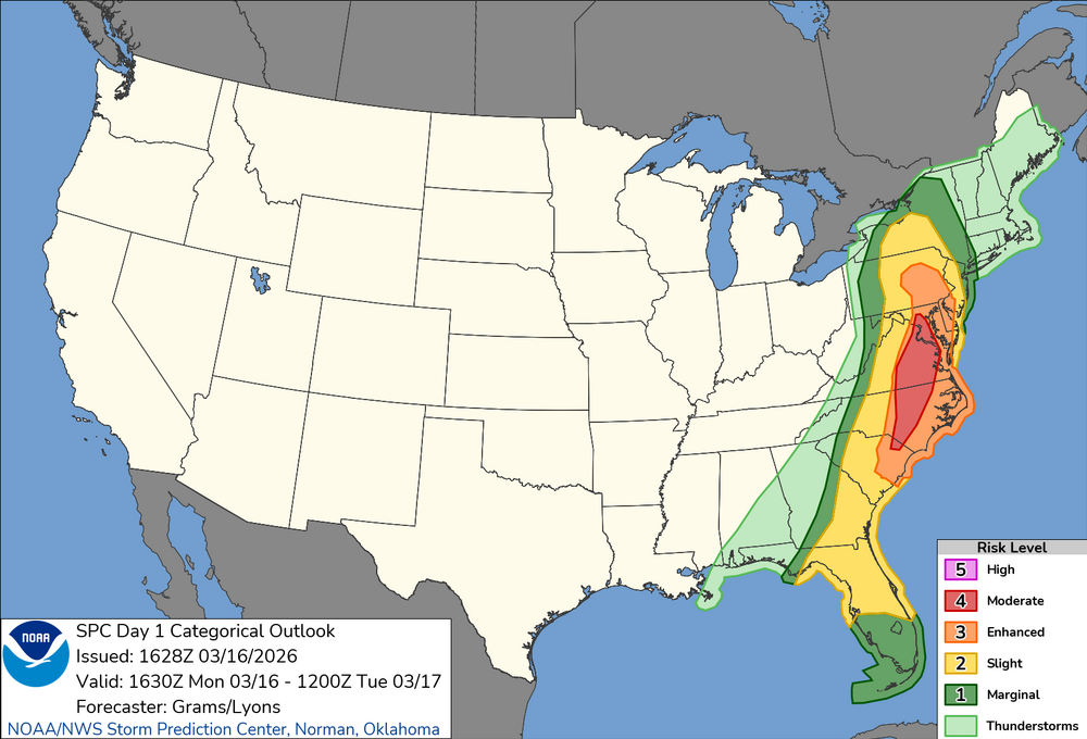
They cut back the risk a good bit. I went from moderate to slight at my work lol.
No changes in a lot of places including Richmond,. It's good though that you don't have to deal with that at your work.
-
1
-
-
1 hour ago, Rhino16 said:
There’s so many rain showers down in NC that it seems like it would be really hard to gain any instability here. Out west had some gaps in the clouds. Maybe some heavier puffs of wind can be brought from aloft in the showers but I don’t see much else for now. I’m interested to see how much steam the line near Lynchburg will have by the time it gets here.
The line of storms in the evening keep showing up on the mesos.. the line around 8 PM for Richmond,… What are your thoughts about that
-
I understand but the national weather service has not backed down one bit
-
Well I guess no one is concerned in this once every five year warning lol. Be safe!
The tornado watch just popped for us
-
Not much juice on here about severe today. People need to really pay attention it could be pretty darn bad.
-
There are injuries, sadly sometimes deaths, and lots of property damage in all kinds of extreme weather. Including winter storms. Snowcrete had THOUSANDS of slip injuries enough to go to ER, just in RVA alone. Nobody "wants" any of that. So let's stop with the halo stuff and just talk about possible scenarios.
-
1 minute ago, MDphotog said:
Pretty big difference in the big models (NAM, Euro) and the HRRR. HRRR has it much earlier in the afternoon for the main line of storms. 2 - 5pm for most of the area.
Not a big HRRR "fan" haha. Not sure of exact verification scores but I know they're not real good
-
 2
2
-
-
22 minutes ago, TSSN+ said:
Lwx said any clearing won’t be till after 12
Considering line doesn't come through til close to 8 that's plenty of time for more destabilization. The 9-10am thing is an opinion only.
-
6 hours ago, high risk said:
It’s still a go in terms of the categories and percentages that they’re rolling with, but the actual text mentions multiple ways this could bust.
So it could, or it couldn't. Solid forecast
-
1
-
-
I think main thread is forgetting mesos at this range can give general idea with details of severe storms but that's about it. It's go time now.
-
15 minutes ago, mattie g said:
Drove by the closest gas station to my house today. A gallon of gas has gone up exactly $1.00 in the past 10 days.
That sucks.
Mid June 2022 gas prices hit $5.00 in Northern Virginia. For much dumber reasons. THAT sucked.
-
3 minutes ago, mattie g said:
Let me ask you a question. If you’re an administrator in a local school district, would you keep the kids in school or would you send them home early? Think long and hard about what the outcomes of these decisions could be and the risk in making one decision or the other, as well as the benefits and drawbacks of both.
Cancel-one day is meaningless even if ONE life is saved. Missed multiple days for cold weather and the obvious long term virtual "learning" in years past. So many young adults STILL struggling bc of that.
-
Kids will be fine -they've missed plenty of time in years past for much dumber reasons. Sounds like a lot of you are thinking you drop back to enhanced.
-
42 minutes ago, TSSN+ said:
Arw/Arw2 0z runs pretty much duds. Would be a marginal risk at best with those looks. Welp guess we will see what the morning brings.
Never even heard of those models
-
41 minutes ago, SomeguyfromTakomaPark said:
Looks like a lotta tornado warnings in the Midwest right now.
And they were just "enhanced"
-
1 hour ago, Eskimo Joe said:
Yea that makes no sense. I don't understand these early dismissals.
Simple-Erring on the side of caution.

March Banter 2026
in Mid Atlantic
Posted
Does anybody have any information regarding tropical tidbits European model being stuck from 12Z yesterday? Hasn't been any runs since then on TT